After finishing the Goat Trail section of California State Route 35 I took California State Route 17 back to the north terminus of California State Route 9 in Los Gatos. My next route of travel was on the entirety of California State Route 9 southwest to Santa Cruz.

California State Route 9 ("CA 9") is an approximately 39 mile State Highway in the Santa Cruz Mountains. CA 9 has a north terminus at CA 17 in Los Gatos of Santa Clara County. The south terminus of CA 9 can be found at at CA 1 in Santa Cruz of Santa Cruz County. CA 9 is generally considered to be one of the more scenic state highways given the terrain it covers in the Redwood strewn Santa Cruz Mountains. The alignment of CA 9 has shifted numerous times over the years but largely has been the same since 1964.

Part 1; a drive on California State Route 9
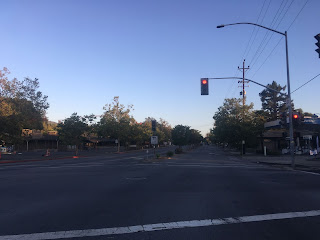
CA 9 southbound beings at CA 17 Exit 200 at Los Gatos-Saratoga Road in the town of Los Gatos.

CA 9 southbound actually backtracks northwest on Los Gatos-Saratoga Road. Los Gatos-Saratoga Road from CA 17 is four-lanes but quickly dips down to a two-lane highway in Monte Sereno. CA 9 at the City Limit of Monte Sereno is signed as a Scenic Route.

CA 9 lternates between a two-lane to four-lane highway between Monte Sereno and Saratoga.


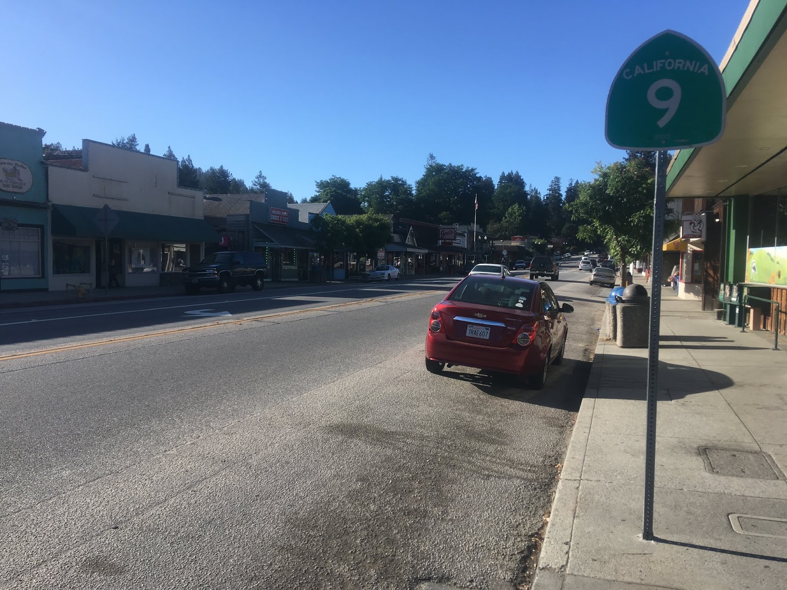
In downtown Saratoga CA 9 swings westward on Big Basin Highway at Postmile SLC R7.397. The original alignment CA 9 used to continue north from Saratoga on Saratoga-Sunnyvale Road straight through the intersection in the below photos.


CA 9 southbound traverses through downtown Saratoga. Saratoga was founded in 1851 and was heavily influenced by the logging industry in the Santa Cruz Range. Saratoga was initially named McCarthysville but received it's modern name in 1865 due to a near by spring a resembling one Saratoga Springs in New York.


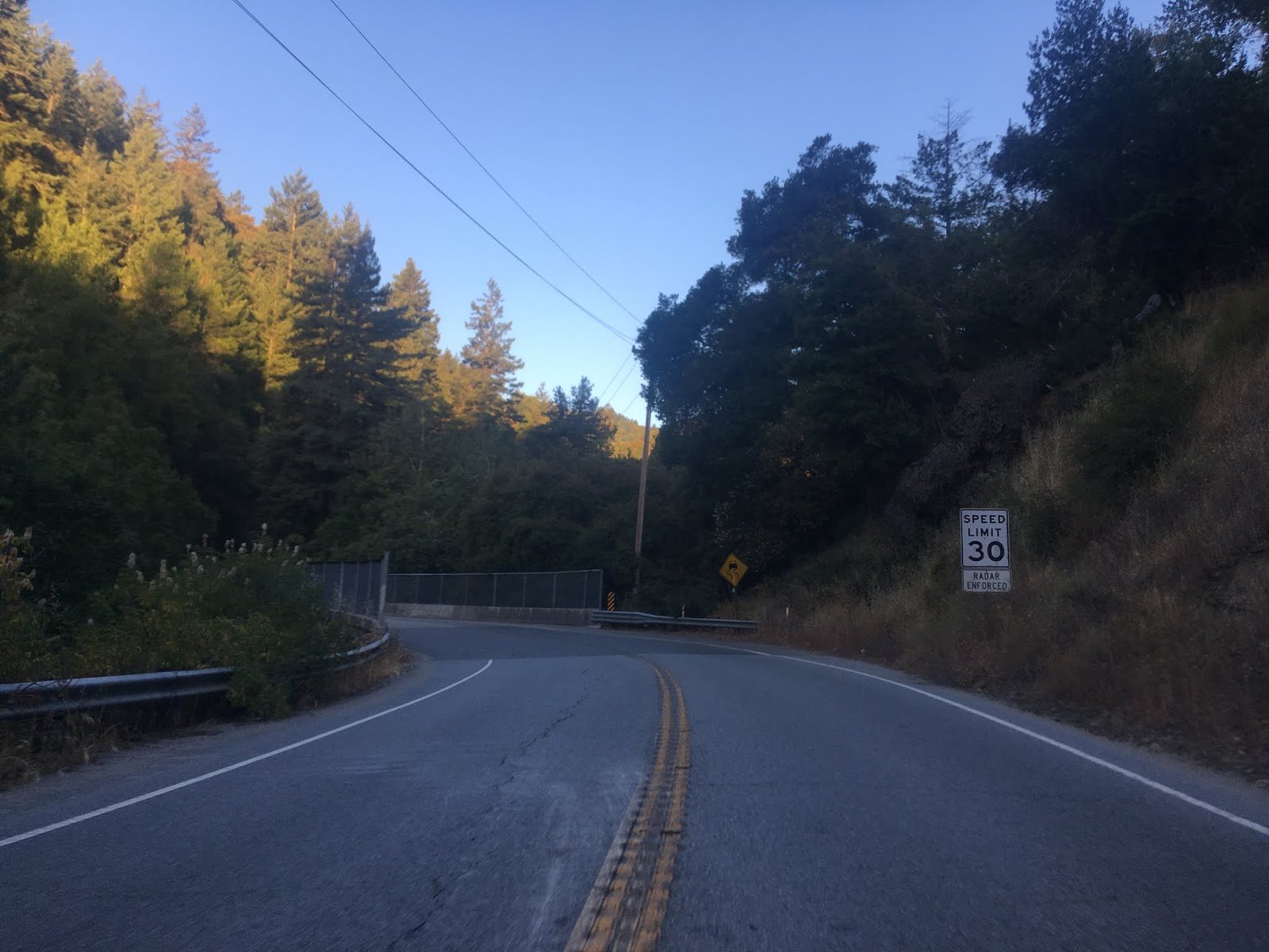
CA 9/Big Basin Way begins to ascend the Santa Cruz Range to Saratoga Gap roughly following the course of Saratoga Creek. The speed limits of CA 9 are slow with several hairpin turns approaching Saratoga Gap but generally has shallow grades.


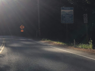
Saratoga Gap is the high point on the routing of CA 9. CA 9 has a junction with CA 35/Skyline Boulevard at the Saratoga Gap. Saratoga Gap serves the Santa Cruz County Line and Boulder Creek is signed as 15 miles ahead on CA 9 south. Santa Cruz is signed as 28 miles away from Saratoga Gap via CA 9 south.


West of the Saratoga Gap CA 9/Big Basin Way a vista at Sempervirens Point at Postmile SCR 25.247. There is an access point to the Summit Meadow Trail from Sempervirens Point.


CA 9/Big Basin Way takes a southwest turn towards the Waterman Gap.


CA 9/Big Basin Way meets the north terminus of CA 236 at the Waterman Gap at Postmile SCR 17.67. Big Basin Way continues on CA 236 as a one-lane state highway to Big Basin Redwoods State Park before reemerging as a two-lane highway backtracking to CA 9 in Boulder Creek. CA 236 and is the original alignment of CA 9. Our previously article on CA 236 and Big Basin Redwoods State Park can be found here.


From the Waterman Gap CA 9 south transitions to the San Lorenzo River southward to Santa Cruz.
From Waterman Gap CA 9 is signed as 8 miles from Boulder Creek whereas Santa Cruz is signed as 21 miles away.


The Waterman Gap cut of CA 9 is fairly gentle but there is one large dead man's curve as the highway drops to the San Lorenzo River.

CA 9 crosses the San Lorenzo River and follows the east bank to almost all the way to Boulder Creek where it crosses back to the west bank. CA 9 has a major junction with Bear Creek Road near the outskirts of Boulder Creek which continues east to CA 17.


CA 9 intersects the southern terminus of CA 236/Big Basin Way in Boulder Creek at Postmile SCR 13.030. From CA 236 Santa Cruz is signed 14 miles to the south on CA 9.

Boulder Creek was settled in the mid-1870s when it was built to service the terminus of the San Lorenzo Logging Flume. The San Lorenzo Logging Flume was supplemented by the Santa Cruz & Felton Railroad which also terminated in Boulder Creek. Boulder Creek still largely resembles a 1870s Californian logging town and generally acts as something of a suburb to Santa Cruz today.

Immediately south of Boulder Creek the community of Brookdale is located 1 mile to the south on CA 9 whereas Ben Lomond can be found 3 miles away.

There was an active bridge repair project ongoing between Brookdale and Ben Lomond when I passed through.


Ben Lomond is actually named after a nearby mountain of the same name which apparently means "Beacon Peak" in Gaelic. Apparently the community became officially known as "Ben Lomond" at some point in 1887. I'm fairly certain that CA 9 originally ran on Mill Street when it was originally signed as it is very clearly central point of the community.


From Ben Lomond the community of Felton is signed 3 miles to the south on CA 9 whereas Santa Cruz is shown as 10 miles away.

CA 9 crosses the San Lorenzo River a couple times entering the community of Felton.


The Felton Covered Bridge is located just off of CA 9 on Graham Hill Road at Postmile 6.457. The Felton Covered Bridge was completed in 1892 and has a 80 foot long span over the San Lorenzo River. Graham Hill Road along with Mount Hermon Road serves a shortcut to northbound CA 17.


Felton was the southern terminus of the San Lorenzo Valley Logging Flume and much like Boulder Creek still resembles a Californian logging town.

CA 9 south of Felton to Santa Cruz is lightly used and is fairly curvy. Henry Cowell Redwoods State Park is located on CA 9 south of Felton.


The weather on CA 9 started to change towards gloomy and foggy approaching Santa Cruz.

CA 9 crosses part of the old rail alignment of the Santa Cruz & Felton Railroad.

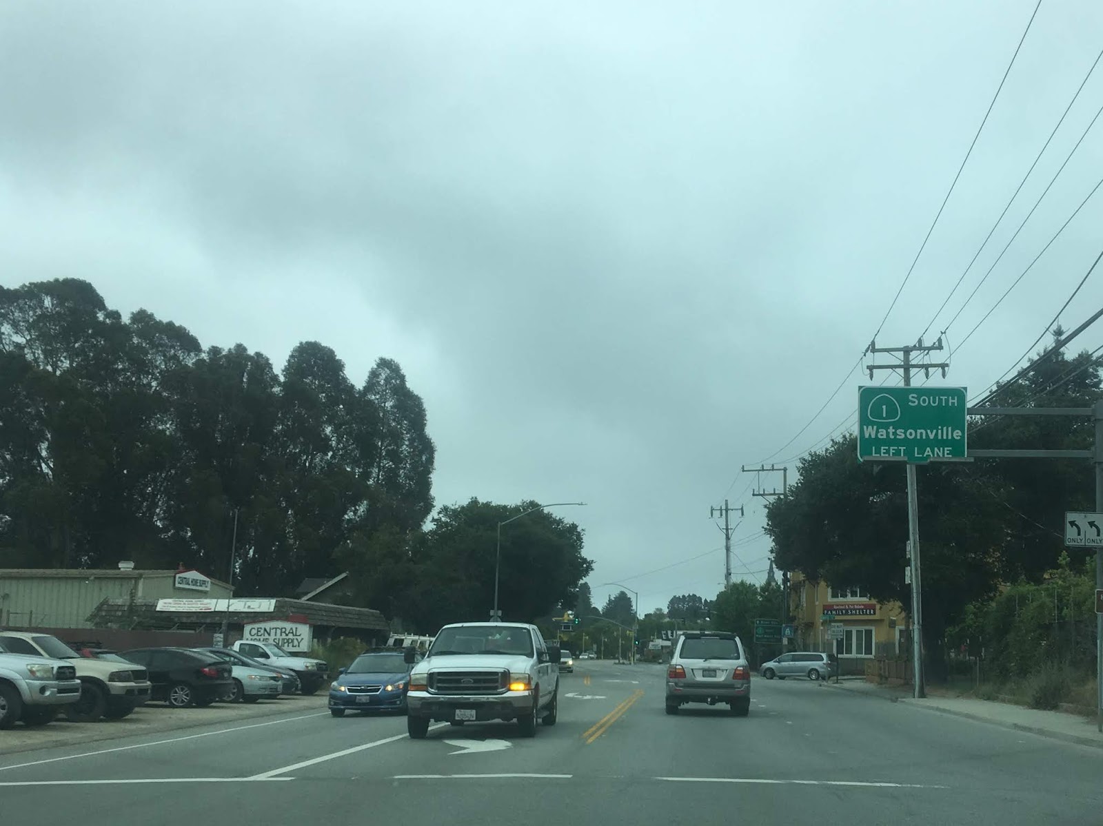
CA 9 emerges out of the Santa Cruz Range into the City of Santa Cruz where it terminates at CA 1.


Part 2; the history of California State Route 9
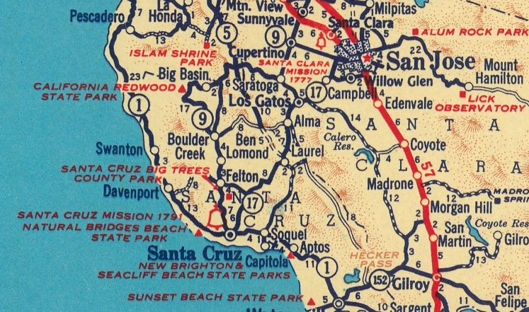
CA 9 was substantially longer when first signed in 1934. CA 9 and the rest of the initial run of Sign State Routes were announced in the August 1934 California Highways & Public Works. California State Route 9 is shown as a highway originating from Santa Cruz north to Milpitas via Redwood Park (Big Basin).


CA 9 in it's original form appears on the 1935 Goshua Highway Map of California.

From CA 17 (originally CA 13) the routing of CA 9 would have used the following Legislative Routes:
CA 9 traveled west from Milpatas on CA 17 along Legislative Route 113 ("LRN 113") via; Alviso-Milpatas Road and 1st Street to Alviso. From Alviso LRN 113 continued south on Gold Street and west to Mathilda Avenue. The original alignment of LRN 113 is largely buried under the CA 237 freeway but it can be seen here on this 1935 California Division of Highways Map of Santa Clara County.

LRN 113 was realigned out of Alviso by 1958 as can be seen on the Division of Highways State Map from said year.

LRN 113 was created in 1933 according to CAhighways.org and became CA 237 during the 1964 State Highway Renumbering.
CAhighways.org on LRN 113
CA 9 traveled south on LRN 114 via Mathilda Avenue to the El Camino Real/US 101 in Sunnyvale. CA 9 on LRN 114 took an eastern jog on El Camino Real/US 101 before turning south on Sunnyvale-Saratoga Road. CA 9 continued south LRN 114 via Sunnyvale-Saratoga Road to Big Basin Way in downtown Saratoga. This early alignment can be seen on the 1935 Division of Highways Map of Santa Clara County.

LRN 114 became the original alignment of CA 85 during the 1964 California Highway Renumbering. LRN 114 was adopted in 1933 according to CAhighways.org.
CAhighways.org on LRN 114
CA 9 traveled west from Saratoga on LRN 42 to Big Basin State Park. According to CAhighways.org the history of State Highway access to Big Basin began in 1913 when the Legislative Chapter 398 approved Legislative Route 42 ("LRN 42.") The original definition of LRN 42 was as follows:
"The survey and construction of a state highway from the point known as Saratoga Gap on the line between the counties of Santa Clara and Santa Cruz, extending thence by the practicable route in a generally SW-ly direction along the ridge between the San Lorenzo and Pescadero creeks to the present boundary of the California State Redwoods Park, thence into the California State Redwoods Park in Santa Cruz County to Governor's Camp, and thence through said park to the boundary thereof at Bloom's Mill."
State Highway access to Big Basin was enhanced further in 1917 when Legislative Chapter 703 created Legislative Route 44. The original definition of LRN 44 was as follows:
"That certain road situated in Boulder Creek township, county of Santa Cruz... Beginning at the intersection of Main and Lorenzo Streets in the town of Boulder Creek, thence running in a NW-ly direction over the present traveled road to the Sequoia schoolhouse, thence running over the road known as the Boulder Creek and state park road to the E-ly boundary of the California Redwood Park..."
The routes of what would become Big Basin Highway via LRN 42 and LRN 44 can be seen passing through California Redwoods State Park on the 1917 California State Automobile Association Map. LRN 42 and LRN 44 were developed off of preexisting logging roads.

LRN 42 and LRN 44 can be seen on the 1918 Division of Highways State Map. LRN 42 is shown as a special appropriations road whereas as LRN 44 is shown as a proposed highway.


As noted above the concrete arch bridges over Boulder Creek on what was LRN 44 were completed by 1921. The completion of LRN 44 is noted on the 1922 Division of Highways State Map which shows the entire Big Basin Highway under state maintenance.


CA 9 used LRN 116 to reach CA 1 in southward in Santa Cruz. LRN 116 was adopted in 1933 according to CAhighways.org.
CAhighways.org on LRN 116
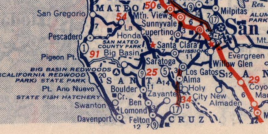
CA 9 through Big Basin Redwoods State Park appears clearly on the 1937 Goshua Highway Map of California.

Whereas the first commercial map to show CA 9 on LRN 116 from Boulder Creek to Waterman Gap that I could find was the 1940 Rand McNally Map of California.

The first Division of Highways document that I could find which shows CA 9 on LRN 116 between Boulder Creek and Waterman Gap is the November/December 1951 California Highways & Public Works. CA 9 between Boulder Creek to Waterman Gap on LRN 116 appears on a list of approved projects for the 1952-53 fiscal year. It remains unclear why CA 9 was pushed off of Big Basin Highway but it can likely be assumed that it was intended to aid travel continuity across the Santa Cruz Mountains. LRN 42 and LRN 44 would become CA 236 during the 1964 State Highway Renumbering.

The changes described above to CA 9 during the 1964 California Highway Renumbering can be observed by comparing the 1963 Division of Highways State Map to the 1964 Edition:
1963 Division of Highways State Map


1964 Division of Highways Map


The initial definition of CA 9 after the 1964 State Highway Renumbering had it looping from CA 17 in Los Gatos to CA 17 in Santa Cruz. This definition implies CA 9 multiplexed CA 1 east briefly in Santa Cruz to reach CA 17. According to CAhighways.org 1981 Legislative Chapter 292 truncated the south terminus of CA 9 back to CA 1 in Santa Cruz.

As an additional reference the 1935 California Division of Highways Map of Santa Cruz County can be used to observe early LRN 42, LRN 44, and LRN 116.


California State Route 9 ("CA 9") is an approximately 39 mile State Highway in the Santa Cruz Mountains. CA 9 has a north terminus at CA 17 in Los Gatos of Santa Clara County. The south terminus of CA 9 can be found at at CA 1 in Santa Cruz of Santa Cruz County. CA 9 is generally considered to be one of the more scenic state highways given the terrain it covers in the Redwood strewn Santa Cruz Mountains. The alignment of CA 9 has shifted numerous times over the years but largely has been the same since 1964.

Part 1; a drive on California State Route 9
CA 9 southbound beings at CA 17 Exit 200 at Los Gatos-Saratoga Road in the town of Los Gatos.

CA 9 southbound actually backtracks northwest on Los Gatos-Saratoga Road. Los Gatos-Saratoga Road from CA 17 is four-lanes but quickly dips down to a two-lane highway in Monte Sereno. CA 9 at the City Limit of Monte Sereno is signed as a Scenic Route.


CA 9 lternates between a two-lane to four-lane highway between Monte Sereno and Saratoga.


In downtown Saratoga CA 9 swings westward on Big Basin Highway at Postmile SLC R7.397. The original alignment CA 9 used to continue north from Saratoga on Saratoga-Sunnyvale Road straight through the intersection in the below photos.


CA 9 southbound traverses through downtown Saratoga. Saratoga was founded in 1851 and was heavily influenced by the logging industry in the Santa Cruz Range. Saratoga was initially named McCarthysville but received it's modern name in 1865 due to a near by spring a resembling one Saratoga Springs in New York.


CA 9/Big Basin Way begins to ascend the Santa Cruz Range to Saratoga Gap roughly following the course of Saratoga Creek. The speed limits of CA 9 are slow with several hairpin turns approaching Saratoga Gap but generally has shallow grades.


Saratoga Gap is the high point on the routing of CA 9. CA 9 has a junction with CA 35/Skyline Boulevard at the Saratoga Gap. Saratoga Gap serves the Santa Cruz County Line and Boulder Creek is signed as 15 miles ahead on CA 9 south. Santa Cruz is signed as 28 miles away from Saratoga Gap via CA 9 south.


West of the Saratoga Gap CA 9/Big Basin Way a vista at Sempervirens Point at Postmile SCR 25.247. There is an access point to the Summit Meadow Trail from Sempervirens Point.


CA 9/Big Basin Way takes a southwest turn towards the Waterman Gap.


CA 9/Big Basin Way meets the north terminus of CA 236 at the Waterman Gap at Postmile SCR 17.67. Big Basin Way continues on CA 236 as a one-lane state highway to Big Basin Redwoods State Park before reemerging as a two-lane highway backtracking to CA 9 in Boulder Creek. CA 236 and is the original alignment of CA 9. Our previously article on CA 236 and Big Basin Redwoods State Park can be found here.


From the Waterman Gap CA 9 south transitions to the San Lorenzo River southward to Santa Cruz.

From Waterman Gap CA 9 is signed as 8 miles from Boulder Creek whereas Santa Cruz is signed as 21 miles away.


The Waterman Gap cut of CA 9 is fairly gentle but there is one large dead man's curve as the highway drops to the San Lorenzo River.

CA 9 crosses the San Lorenzo River and follows the east bank to almost all the way to Boulder Creek where it crosses back to the west bank. CA 9 has a major junction with Bear Creek Road near the outskirts of Boulder Creek which continues east to CA 17.


CA 9 intersects the southern terminus of CA 236/Big Basin Way in Boulder Creek at Postmile SCR 13.030. From CA 236 Santa Cruz is signed 14 miles to the south on CA 9.

Boulder Creek was settled in the mid-1870s when it was built to service the terminus of the San Lorenzo Logging Flume. The San Lorenzo Logging Flume was supplemented by the Santa Cruz & Felton Railroad which also terminated in Boulder Creek. Boulder Creek still largely resembles a 1870s Californian logging town and generally acts as something of a suburb to Santa Cruz today.

Immediately south of Boulder Creek the community of Brookdale is located 1 mile to the south on CA 9 whereas Ben Lomond can be found 3 miles away.

There was an active bridge repair project ongoing between Brookdale and Ben Lomond when I passed through.


Ben Lomond is actually named after a nearby mountain of the same name which apparently means "Beacon Peak" in Gaelic. Apparently the community became officially known as "Ben Lomond" at some point in 1887. I'm fairly certain that CA 9 originally ran on Mill Street when it was originally signed as it is very clearly central point of the community.


From Ben Lomond the community of Felton is signed 3 miles to the south on CA 9 whereas Santa Cruz is shown as 10 miles away.

CA 9 crosses the San Lorenzo River a couple times entering the community of Felton.


The Felton Covered Bridge is located just off of CA 9 on Graham Hill Road at Postmile 6.457. The Felton Covered Bridge was completed in 1892 and has a 80 foot long span over the San Lorenzo River. Graham Hill Road along with Mount Hermon Road serves a shortcut to northbound CA 17.


Felton was the southern terminus of the San Lorenzo Valley Logging Flume and much like Boulder Creek still resembles a Californian logging town.

CA 9 south of Felton to Santa Cruz is lightly used and is fairly curvy. Henry Cowell Redwoods State Park is located on CA 9 south of Felton.


The weather on CA 9 started to change towards gloomy and foggy approaching Santa Cruz.

CA 9 crosses part of the old rail alignment of the Santa Cruz & Felton Railroad.

CA 9 emerges out of the Santa Cruz Range into the City of Santa Cruz where it terminates at CA 1.


Part 2; the history of California State Route 9
CA 9 was substantially longer when first signed in 1934. CA 9 and the rest of the initial run of Sign State Routes were announced in the August 1934 California Highways & Public Works. California State Route 9 is shown as a highway originating from Santa Cruz north to Milpitas via Redwood Park (Big Basin).

CA 9 in it's original form appears on the 1935 Goshua Highway Map of California.

From CA 17 (originally CA 13) the routing of CA 9 would have used the following Legislative Routes:
CA 9 traveled west from Milpatas on CA 17 along Legislative Route 113 ("LRN 113") via; Alviso-Milpatas Road and 1st Street to Alviso. From Alviso LRN 113 continued south on Gold Street and west to Mathilda Avenue. The original alignment of LRN 113 is largely buried under the CA 237 freeway but it can be seen here on this 1935 California Division of Highways Map of Santa Clara County.

LRN 113 was realigned out of Alviso by 1958 as can be seen on the Division of Highways State Map from said year.

LRN 113 was created in 1933 according to CAhighways.org and became CA 237 during the 1964 State Highway Renumbering.
CAhighways.org on LRN 113
CA 9 traveled south on LRN 114 via Mathilda Avenue to the El Camino Real/US 101 in Sunnyvale. CA 9 on LRN 114 took an eastern jog on El Camino Real/US 101 before turning south on Sunnyvale-Saratoga Road. CA 9 continued south LRN 114 via Sunnyvale-Saratoga Road to Big Basin Way in downtown Saratoga. This early alignment can be seen on the 1935 Division of Highways Map of Santa Clara County.

LRN 114 became the original alignment of CA 85 during the 1964 California Highway Renumbering. LRN 114 was adopted in 1933 according to CAhighways.org.
CAhighways.org on LRN 114
CA 9 traveled west from Saratoga on LRN 42 to Big Basin State Park. According to CAhighways.org the history of State Highway access to Big Basin began in 1913 when the Legislative Chapter 398 approved Legislative Route 42 ("LRN 42.") The original definition of LRN 42 was as follows:
"The survey and construction of a state highway from the point known as Saratoga Gap on the line between the counties of Santa Clara and Santa Cruz, extending thence by the practicable route in a generally SW-ly direction along the ridge between the San Lorenzo and Pescadero creeks to the present boundary of the California State Redwoods Park, thence into the California State Redwoods Park in Santa Cruz County to Governor's Camp, and thence through said park to the boundary thereof at Bloom's Mill."
State Highway access to Big Basin was enhanced further in 1917 when Legislative Chapter 703 created Legislative Route 44. The original definition of LRN 44 was as follows:
"That certain road situated in Boulder Creek township, county of Santa Cruz... Beginning at the intersection of Main and Lorenzo Streets in the town of Boulder Creek, thence running in a NW-ly direction over the present traveled road to the Sequoia schoolhouse, thence running over the road known as the Boulder Creek and state park road to the E-ly boundary of the California Redwood Park..."
The routes of what would become Big Basin Highway via LRN 42 and LRN 44 can be seen passing through California Redwoods State Park on the 1917 California State Automobile Association Map. LRN 42 and LRN 44 were developed off of preexisting logging roads.

LRN 42 and LRN 44 can be seen on the 1918 Division of Highways State Map. LRN 42 is shown as a special appropriations road whereas as LRN 44 is shown as a proposed highway.


As noted above the concrete arch bridges over Boulder Creek on what was LRN 44 were completed by 1921. The completion of LRN 44 is noted on the 1922 Division of Highways State Map which shows the entire Big Basin Highway under state maintenance.

CA 9 used LRN 116 to reach CA 1 in southward in Santa Cruz. LRN 116 was adopted in 1933 according to CAhighways.org.
CAhighways.org on LRN 116
CA 9 through Big Basin Redwoods State Park appears clearly on the 1937 Goshua Highway Map of California.
Whereas the first commercial map to show CA 9 on LRN 116 from Boulder Creek to Waterman Gap that I could find was the 1940 Rand McNally Map of California.
The first Division of Highways document that I could find which shows CA 9 on LRN 116 between Boulder Creek and Waterman Gap is the November/December 1951 California Highways & Public Works. CA 9 between Boulder Creek to Waterman Gap on LRN 116 appears on a list of approved projects for the 1952-53 fiscal year. It remains unclear why CA 9 was pushed off of Big Basin Highway but it can likely be assumed that it was intended to aid travel continuity across the Santa Cruz Mountains. LRN 42 and LRN 44 would become CA 236 during the 1964 State Highway Renumbering.

The changes described above to CA 9 during the 1964 California Highway Renumbering can be observed by comparing the 1963 Division of Highways State Map to the 1964 Edition:
1963 Division of Highways State Map


1964 Division of Highways Map


The initial definition of CA 9 after the 1964 State Highway Renumbering had it looping from CA 17 in Los Gatos to CA 17 in Santa Cruz. This definition implies CA 9 multiplexed CA 1 east briefly in Santa Cruz to reach CA 17. According to CAhighways.org 1981 Legislative Chapter 292 truncated the south terminus of CA 9 back to CA 1 in Santa Cruz.
As an additional reference the 1935 California Division of Highways Map of Santa Cruz County can be used to observe early LRN 42, LRN 44, and LRN 116.


Comments