
Chowchilla Mountain Road of Mariposa County is one of the
oldest roadways servicing Yosemite National Park. As presently configured this fourteen-mile highway
begins at California State Route 49 near Elliot Corner and terminates at the
Wawona Road in Yosemite National Park.
Chowchilla Mountain Road was constructed as a franchise toll
road over Battalion Pass circa 1869-1870.
The highway was built at behest of Galen Clark to connect the town of
Mariposa to his property near the South Fork Merced River at what is now Wawona. In late
1874 the highway along with Clark’s Station would be purchased by the Washburn
Brothers.
The Washburn Brothers would continue to toll Chowchilla
Mountain Road as part of their Yosemite Stage Route lines. The highway would ultimately become a Mariposa
County public highway in 1917. Mariposa would
later be more directly linked with Yosemite Valley in 1926 following the
completion of the Yosemite All-Year Highway (now California State Route 140).
Chowchilla Mountain Road in modern times remains a largely primitive
Mariposa County owned rural highway with incline grades up to 16%. The
corridor over Battalion Pass requires high clearance in dry conditions and is subject
to winter closures due to snow. Mariposa
County posts several warning placards which attempt to deter tourists from
blindly attempting to following Chowchilla Mountain Road into Wawona. The Wawona side of the highway is often gated
off the by the National Park Service for the winter.

Part 1; the history of Chowchilla Mountain Road
What is now Chowchilla Mountain Road began as a foot trail connecting Mariposa to Galen Clark's property at the South Fork Merced River via Battalion Pass. From Clark's Station travelers could continue north on foot to the floor of Yosemite Valley.
The original trail north from the future site of Wawona over the South Fork Merced River was plotted out by the Mann Brothers in 1855. The initial toll crossing of the South Fork Merced River was simply a large log which was replaced by a primitive bridge known as "Clark's Crossing" soon after Galen Clark arrived in the area. The Mann Trail to Yosemite Valley was approved as a franchise toll facility by Mariposa County on August 4, 1856.
Galen Clark settled near the South Fork Merced River hoping to cure his tuberculosis. In 1857 Clark along with Milton Mann were the first Europeans to locate the nearby Mariposa Grove of Redwood Sequoias. Clark spent the ensuing years attempting to bolster tourism to the South Fork Merced River and the Mariposa Grove. Clark would construct lodging accommodations at the so-called Clark's Station. The 1855-era bridge over the South Fork Merced River was frequently washed out and often repaired. On August 11, 1860, Mariposa County declared the Mann Trail from the South Fork Merced River to Yosemite Valley a public highway.
Galen Clark can be seen below in undated Public Domain photograph.
In 1862 the South Fork Merced River Bridge was washed out again and the crossing was replaced by felled trees. In 1864 President Lincoln signed law which led to the protection of Yosemite Valley and the Mariposa Grove. During early 1868 Galen Clark would petition Mariposa County for funds to construct a new bridge at the South Fork Merced River and widen the existing trail to Mariposa. Clark's new bridge would be completed during the year.
The original Mariposa-Yosemite Trail can be seen on the
1868 California Geological Survey map of Yosemite Valley. The Yosemite Road can be seen beginning south of Mariposa at Mormon Bar. From Mormon Bar the road continued east to the Chowchilla River Canyon (shown as Chowchilla Crack). From the river canyon the Mariposa-Yosemite Trail east to Clark's Station via what is now Battalion Pass.
Construction of the expanded Chowchilla Mountain Road broke ground during 1869 and would be completed by 1870 as a franchise toll road. During 1870 Galen Clark would partner with Edwin Moore to expanding lodging accommodations at the rebranded Clark & Moore's Station.
Chowchilla Mountain Road can be seen for the first time on the
1870 California Geological Survey map of Yosemite Valley. The then new corridor (shown as Wagon Road to Clark's) is shown be mostly north of the Mariposa-Yosemite Trail (shown as Old Trail). Chowchilla Mountain Road crossed over the namesake mountain at Battalion Pass which lies at 5,557 feet above sea level.
The high elevation of Battalion Pass rendered it being subject to issues with winter snow. This undated photo from the Yosemite Digital Archives shows women attempting to push a wagon up a snowy Chowchilla Mountain Road (
courtesy Sierra News Online).
The 1870 California Geological Survey map also displays Galen Clark's proposed Wawona Road to Yosemite Valley. The planned Wawona Road is shown mostly to the west of the existing Mann Trail. Clark fell under financial hardship after expanding Clark & Moore's Station and attempting to build the Wawona Road. This hardship would lead to Clark selling his interests to the Washburn Brothers during December 1874.
After the Washburn Brothers took over Galen Clark's holdings they would place a cover on the South Fork Merced River Bridge. The structure would become more popularly known as the Wawona Covered Bridge and still stands (see Part 3).
The first structure in the Wawona Hotel complex built by the Washburn Brothers complex dates back to 1876. The name "Wawona" is claimed to originate from a similar Mono Tribal word describing a Redwood Sequoia Tree. The Washburn Brothers completed the Wawona Road from their new hotel to Yosemite Valley by 1879. When new the Wawona Road and hotel complex were only served by Chowchilla Mountain Road.
Despite only being less than thirty miles south of Yosemite Valley the Wawona Hotel was several days away by foot through the wilderness. The Wawona Hotel was becoming popular and interest in a stage service to Yosemite Valley was becoming a viable concept. Thus, the Yosemite Stage & Turnpike Company was founded in 1882 to facilitate stage route travel to the Wawona Hotel and Yosemite Valley. Washburn stage lines were pressed into service along existing Chowchilla Mountain Road.
A Yosemite Stage & Turnpike wagon train can be seen on Chowchilla Mountain Road in an
undated photo (courtesy yosemite.ca.us).
Chowchilla Mountain Road was supplemented by the Yosemite Stage Road in 1882. The Yosemite Stage Road can be seen connecting the Fresno Big Trees (Mariposa Grove) to Madera on the
1882 Bancroft's Map of California. The original Yosemite Stage Road passed through Fresno Flats and Coarsegold as it descended through the Sierra Nevada foothills following much of the eastern bank of the Fresno River towards Madera.
Chowchilla Mountain Road is also prominently displayed on the 1882 Bancroft's map.
The Yosemite Stage Road became popular enough that it drew attention of the Southern Pacific Railroad for the development of a spur line out of Berenda. Raymond was founded as Wild Cat Station and was the north terminus of the San Joaquin Valley & Yosemite Railroad which was opened by the Southern Pacific Railroad in February 1886. The San Joaquin Valley & Yosemite Railroad received its first passengers by March of 1886, and the community of Wild Cat Station became a popular trailhead for stages heading to the Wawona Hotel and Yosemite National Park. Post Office was established in July of 1886 and the community's name was changed to Raymond. Following the establishment of Raymond the Yosemite Stage Road would be realigned via Grub Gulch and Miami Mountain to reach it.
Despite the declining popularity of Chowchilla Mountain Road, it would remain tolled until made a public in 1917. The decline would be further accentuated when the Yosemite-All Year Highway (California State Route 140 by August 1934) was open from Mariposa to El Portal on July 31, 1926. During August 1932 the Federal Government would purchase the Wawona Hotel complex and adjacent properties from the Washburn family. This purchase was made in advance of the modern Wawona Road opening in 1933 following the completion of the Wawona Tunnel.
This early 1926 National Automobile Club Motor Guide map of the Yosemite area (courtesy Nick Cuccia) displays Chowchilla Mountain Road from Cold Springs to Battalion Pass as having a 16% incline grade.
This late 1920s Automobile Club of Southern California strip map (courtesy Nick Cuccia) displays Chowchilla Mountain Road still as the primary highway from Mariposa to Wawona.
Chowchilla Mountain Road from Elliott Corner to Cold Springs can be seen in detail on the 1947 United States Geological Survey map of Stumpfield Mountain.
Chowchilla Mountain Road east from Cold Springs to the Chowchilla River Canyon be seen on the 1953 United States Geological Survey map of Bass Lake.
The 1956 United States Geological Survey map displays Chowchilla Mountain Road in the vicinity of Battalion Pass east to the Wawona Hotel in Yosemite National Park. The Summit Campground is shown to have been originally located west of the pass.
Despite no longer being a primary highway in Yosemite National Park the entirety of Chowchilla Mountain Road remains maintained by Mariposa County. Almost the entire roadway remains unsurfaced and is subject to winter closures. The portion a short distance east of Cold Springs is impassable to low clearance vehicles.
Chowchilla Mountain Road no longer appears on the Yosemite National Park brochure map. The roadway does appear as a four-wheel drive road on the
standard map on nps.gov. From Wawona traffic heading west on Chowchilla Mountain Road crosses the former Wawona Golf Course towards the Wawona Loop Trail. The National Park Service does close a gate blocking Chowchilla Mountain Road during adverse weather.
Chowchilla Mountain Road in modern times has been the subject of many GPS related horror stories. I found this particular story from the San Francisco Gate about a Thanksgiving 2003 Yosemite run courtesy of MapQuest to be the most interesting of the lot. I think it speaks to what happens when you go into uncharted territory blindly and don't have a good grasp on when to stop what you're doing.
Part 2; a drive on Chowchilla Mountain Road to Battalion Pass
Eastbound Chowchilla Mountain Road begins at California State Route 49 near the site of Elliott Corner.
As eastbound Chowchilla Mountain Road begins traffic can find a historic plaque regarding the history of Elliott Corner. Said property was a 320-acre ranch owned by Charles Elliott. Elliott Corner is where travels to Yosemite had to decide whether to continue east on the fourteen-mile Chowchilla Road or the much longer detour via Cedarbrook to the Yosemite Stage Road at Miami Mountain. The detour towards Miami Mountain was ten miles longer but had far less hellacious grades compared to the climb towards Battalion Pass. Elliott Corner was bypassed by the modern alignment of California State Route 49 which opened south to the Madera County line during May 1969.
The paved portion of eastbound Chowchilla Mountain Road turns right at East Westfall Road.
Chowchilla Mountain Road makes a left-hand turn at the beginning of Harris Cutoff Road. Traffic is warned that the first segment of Chowchilla Mountain Road is "not maintained during winter November through May."
Eastbound Chowchilla Mountain Road enters Sierra National Forest.
Chowchilla Mountain Road intersects Forest Road 05S03 (Standard Mill Road).
Chowchilla Mountain Road crests a small ridge located at 3,445 feet above sea leave and drops down to Cold Springs Creek. The creek is located at about 3,100 feet above sea level.
Chowchilla Mountain Road passes through Cold Springs Meadow which still has several private residences. Cold Springs was a major waypoint on the road to Wawona and had Post Office Service until 1883. The small community of Miami was also once located nearby.
A short second segment of pavement begins as Chowchilla Mountain Road approaches the opposite end of Harris Cutoff Road.
As the pavement gives way a second time on Chowchilla Mountain Road traffic is advised via a placard that there is no access to Yosemite. These placards appear to be in place as a deterrent to tourists blindly following GPS directions which don't factor for the haggard conditions ahead.
Chowchilla Mountain Road begins to ascend towards Battalion Pass. The roadway gains just over 2,000 feet in elevation east of from Harris Cutoff Road towards the pass with incline grades peaking at 16%. The graded portion of the roadway ends just past the last private residences. Traffic is warned the ascent ahead is not "impassable and not maintained during November to May.
The grade along Chowchilla Mountain Road rapidly degrades approaching Forest Road 05S09T (Six Forks Road).


Chowchilla Mountain Road continues to ascend through several
haggard and rutted sections to a small creek.
This creek becomes the East Fork Chowchilla River as it flows downhill.
Chowchilla Mountain Road makes one final eastbound climb to Battalion Pass. Forest Road 04S04 (Ten Mile Grade) crosses over Chowchilla Mountain Roat at the pass.
The path on the left carries eastbound Chowchilla Mountain Road ahead approximately five miles to Wawona. At times there is a closure gate at the intersection with Summit Road near the Summit Campground. Chowchilla Mountain Road crosses the Big Creek Bridge (constructed in 1940) approaching Wawona.
This view faces south from Battalion Pass towards the Chowchilla
River Canyon.
Part 3; the Wawona Hotel and Covered Bridge
The Wawona Hotel and Wawona Covered Bridge are located just east of the terminus of Chowchilla Mountain Road. Both structures are located at about 4,000 feet above sea level at the South Fork Merced River. These photos of the hotel were taken when it was closed for the season in 2019.
The Wawona Hotel is the location of the only gas station on Wawona Road. The price of gas tends to be at least a dollar higher than found in Oakhurst.
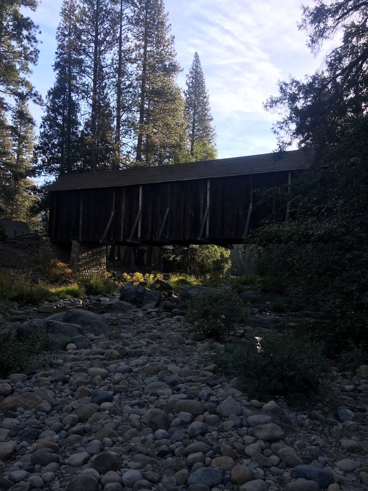
The modern Wawona Road crosses the South Fork Merced River via a bridge constructed in 1937. The Wawona Covered Bridge is located upstream to the right of this photo and has been restored several times.
The Wawona Covered Bridge can be accessed via Forest Drive at the Pioneer Yosemite History Center.
One of the Yosemite Stage & Turnpike Company wagons is on display in the barn next to the Wawona Covered Bridge.
The Wawona Covered Bridge as stated above was part of the Wawona Road until 1937. The Wawona Covered Bridge was damaged by flooding on the South Fork Merced River in 1955 but was reconstructed as a center piece of the Pioneer Yosemite History Center. The covered span is one of twelve remaining in California.
The Pioneer Yosemite History Center has various other buildings from various periods of tourism within Yosemite National Park.


Comments
I found the gate opening date on a Yosemite forum as I was writing the blog. Apparently the Yosemite side opened on April 21st. I’ll be back out in the Wawona area after the reservation period ends on 8/15, hopefully I’ll have my mountain bike.