
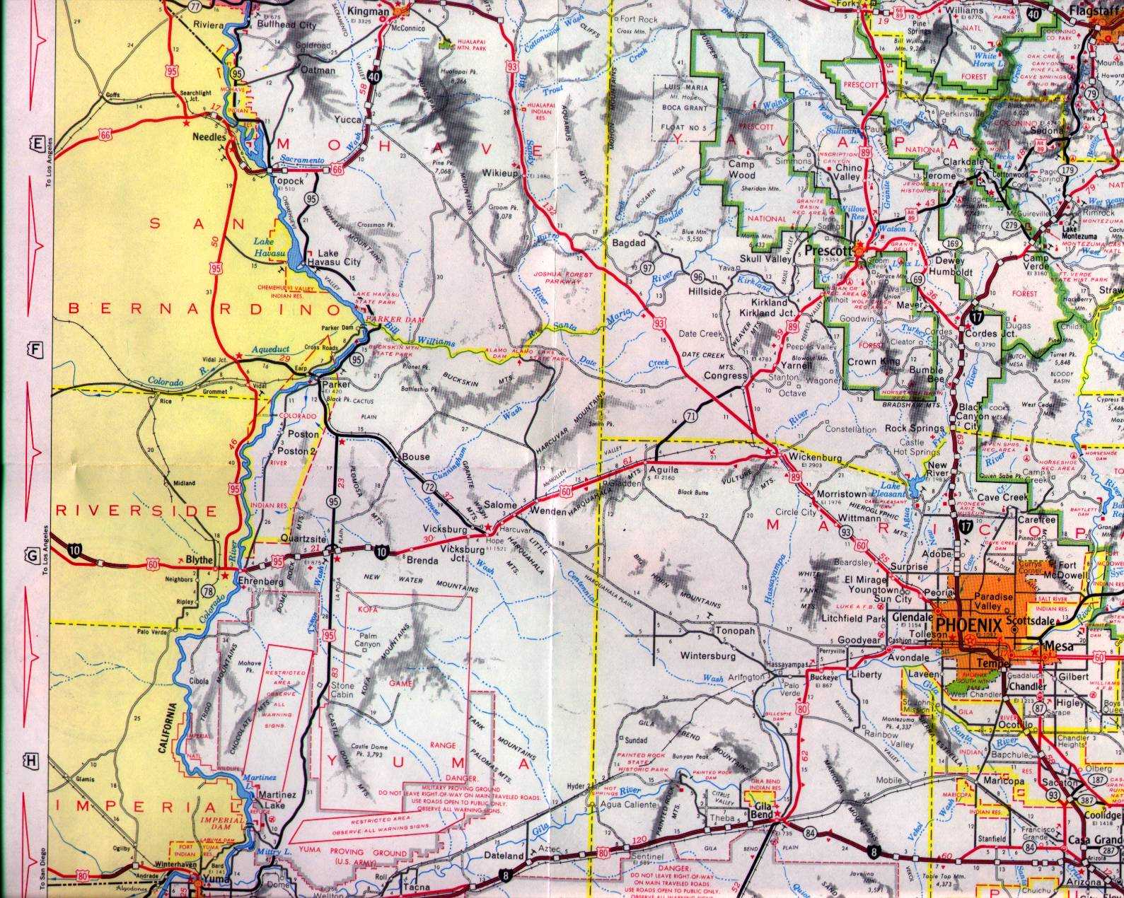
Wickenburg is one of the oldest towns in the state of Arizona and is located on the Hassayampa in Maricopa County. Wickenburg historically has served as the crossroads of numerous US Routes from the inception of the US Route System during November 1926. This blog will explore the history of US Route designations in the town of Wickenburg. Pictured as the blog cover is the then new Hassayampa River Bridge facing east carrying US Route 60, US Route 70 and US Route 89 during 1937. Wickenburg can be seen centered around US Route 60, US Route 70, US Route 89 and Arizona State Route 93 on the 1951 Gousha Highway Map of Arizona.

Part 1; the history of the US Routes through Wickenburg
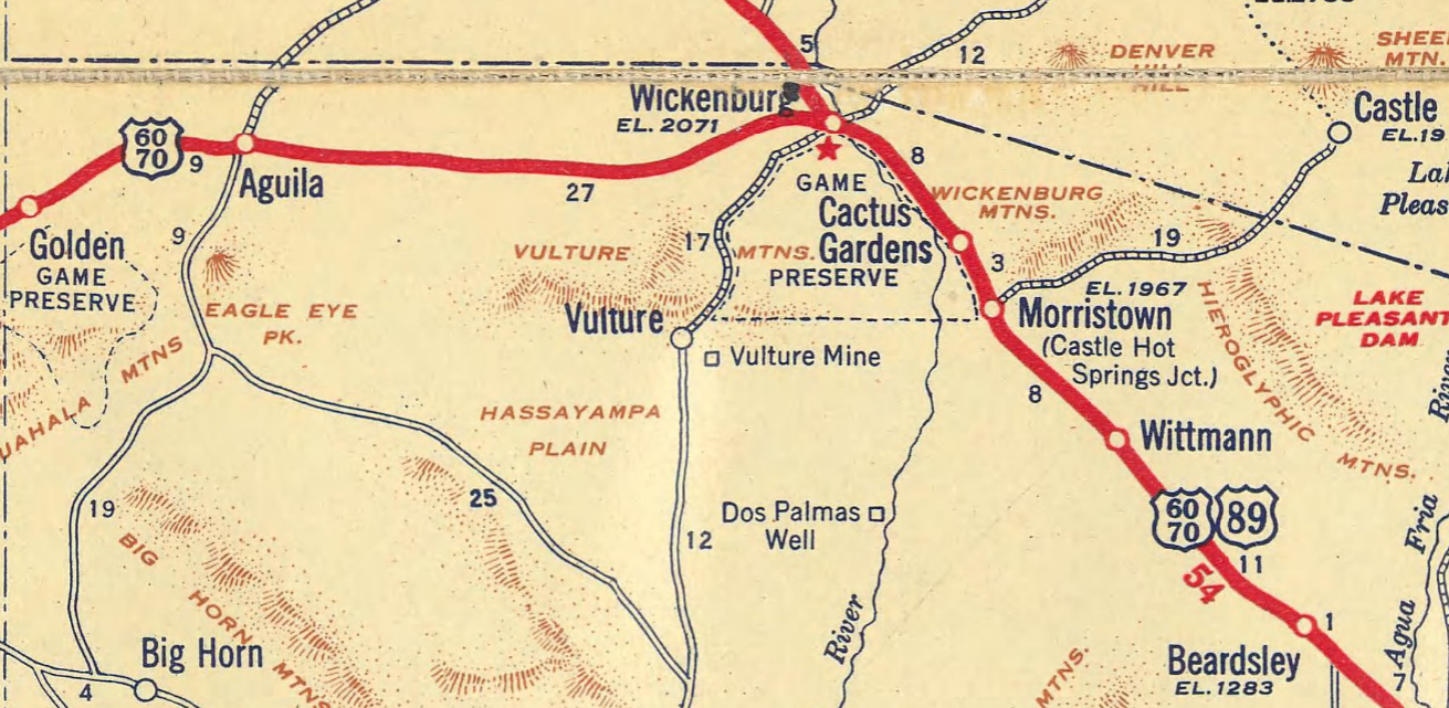
The founding of Wickenburg is tied to the Vulture Mine. Henry Wickenburg had arrived in the vicinity of the Vulture Mountains following the mining claims of the La Paz Mining District being struck during 1862. The Vulture Mine was discovered by Henry Wickenburg in 1863 which led to town bearing his name being plotted. The location of the town of Wickenburg was ideal as it was located along the Ehrenburg-Prescott Highway near the Hassayampa River. Wickenburg can be seen along the Ehrenburg-Prescott Highway located in what was Yavapai County on 1865 Gensoul Map of Arizona Territory.

During 1866 Wickenburg barely lost a vote to be assigned the Arizona Territory capital. During 1895 the Atchison, Topeka & Santa Fe Railway (ATSF) reached Wickenburg and constructed a depot on Frontier Street. Wickenburg would formally incorporate as a town during 1909.
In the early drafts of the US Route System, in Arizona US Route 89 didn't extend south of Flagstaff. US Route 280 was planned to be aligned from US Route 60 (which became US Route 66) from Ashfork south to US Route 80 in Phoenix by way of Wickenburg. Planned US Route 280 can be seen passing through Wickenburg along Tegner Street and Wickenburg Way southbound towards Phoenix on the 1927 Rand McNally Highway Map of Arizona.

The US Route System was finalized by the American Association of State Highway Officials (AASHO) on November 11, 1926. What was planned as US Route 280 became an extension of US Route 89 when the US Route System was finalized. US Route 89 inherited the routing through Wickenburg planned for US Route 280. The descriptions of the initial US Routes in Arizona defined by AASHO can be seen below.


The Ehrenburg-Prescott Highway was eventually renamed as the "Sunkist Highway." The Sunkist Highway from Wickenburg west to the Colorado River near Ehrenburg was added to the State Highway System by the Arizona State Highway Commission as part of the original Arizona State Route 74 on September 9, 1927. The original Arizona State Route 74 can be seen passing through Wickenburg on Wickenburg Way west of Tegner Street on the 1927 Arizona State Highway Commission Map.

US Route 60 would rapidly be extended after the US Route System was created and would come into play in California and Arizona during the early 1930s. A letter from the AASHO Executive Secretary to the California State Highway Engineer dated Marth 30, 1931, noted US Route 60 had been tentatively approved to be extended to California during the AASHO Executive Committee on May 26, 1930. The approval of US Route 60 being extended to California carried the stipulation that the Colorado River Bridge in Blythe be purchased by the California Division of Highways and Arizona State Highway Commission. The letter noted California and Arizona had taken steps through their respective legislatures to purchase the Colorado River Bridge and the terminus of US Route 60 to be at an undisclosed location in Los Angeles.


A letter from the California State Highway Engineer to the AASHO Executive Secretary on April 13, 1931, noted legislation to purchase the Colorado River Bridge had been passed in California. The purchase of the Colorado River Bridge effectively made the extension of US Route 60 into California through Arizona active. Legislative Route Number 64 was extended from Blythe to the Arizona state line by way of 1931 Legislative Chapter 82. Within Arizona, US Route 60 multiplexed US Route 89 west of Phoenix to Wickenburg. West of Wickenburg US Route 60 replaced the entirety of Arizona State Route 74.

US Route 60 and Arizona State Route 74 can be seen running concurrently from Wickenburg west to the Colorado River Bridge on the 1933 Midwest Map Company Arizona Highway Map. US Route 60 can be seen passing through Wickenburg via Wickenburg Way.

A September 1934 exchange of letters between the California State Highway Engineer and AASHO acknowledged US Route 70 had been extended into California with an endpoint following US Route 60 into downtown Los Angeles. Within Arizona, US Route 70 would multiplex US Route 60 from Globe west to the California state line. Within Wickenburg, US Route 70 multiplexed US Route 60 on Wickenburg Way.


US Route 60 and US Route 70 can be seen multiplexing through Wickenburg on the 1937 Gousha Map of Arizona.
The May 1937 Arizona Highways featured the numerous highway improvements then new in Wickenburg. US Roure 60/US Route 70/US Route 89 can be seen multiplexing over a new bridge over the Hassayampa River. US Route 60 and US Route 70 are featured passing through downtown Wickenburg via a new railroad underpass on Wickenburg Way. The new Hassayampa River Bridge and ATSF Railway underpass were opened to traffic on April 26, 1937. The article references Arizona State Route 79 being concurrent with US Route 89 from Prescott southbound into Wickenburg.


During September 1935 US Route 93 had been extended into Arizona to a terminus concurrent with US Route 466 to Kingman. The State Legislature had adopted proposed extension of US Route 93 on March 13, 1937. The proposed extension of US Route 93 was planned to be aligned to Aguila via Wikieup, Signal and Alamo.

On May 26, 1937, the Arizona State Highway engineer submitted a proposal to extend US Route 93 from Kingman to Nogales. The proposal included a temporary routing for US Route 93 which would be concurrent with US Route 89 from Ashfork south to Wickenburg via Prescott. The permanent routing of US Route 93 was similar as what had been adopted by the State Legislature during the previous March.

Construction of the extension of US Route 93 from Kingman to Wickenburg was approved on August 8, 1942.

The 1951 Gousha Highway Map of Arizona depicts numerous highways passing through Wickenburg. US Route 89 and Arizona State Route 93 are shown entering Wickenburg via Tegner Street from Congress Junction. US Route 60 and US Route 70 are shown passing through Wickenburg via Wickenburg Way. East of Tegner Street US Route 60, US Route 70 and US Route 89 are shown multiplexing towards Phoenix. Arizona State Route 71 is displayed as having inherited the initial planned routing of US Route 93 to Aguila.
During the early 1950s Arizona State Route 93 was extended to the Mexican border in Nogales. Arizona State Route 93 was extended through Wickenburg via a multiplex of US Route 60, US Route 70 and US Route 89 east of Tegner Street on Wickenburg Way. The extended Arizona State Route 93 can be seen on the 1956 Gousha Map of Arizona.

On January 15, 1958, the Arizona Highway Department submitted an application to AASHO to extend US Route 93 to Wickenburg. The AASHO Executive Committee rejected the application on June 26, 1958, due to the permanent alignment Arizona State Route 93 not having been constructed south of Arizona State Route 71.


The new routing of Arizona State Route 93 south of Arizona State Route 71 was formally adopted on November 6, 1961. The entirety of Arizona State Route 93 between Kingman and Wickenburg would be designated as the Joshua Tree Parkway during 1963.

During 1962 the Hassayampa River Bridge was twinned. The existing span was moved carrying westbound US Route 60/US Route 70 traffic in addition to northbound US Route 89 and Arizona State 93. The ATSF Railway underpass on Wickenburg Way was also expanded during 1962.
The Arizona Highway Department submitted a request to extend US Route 93 to Nogales on April 28, 1965. The AASHO Executive Committee only granted an extension of US Route 93 to US Route 89 north of Wickenburg. The rejection of US Route 93 being extended to Nogales was due to the routing being completely concurrent with US Route 89 south of Wickenburg.


On June 24, 1969, AASHO approved an Arizona Highway Department request to truncate US Route 70 from the California State Line to Globe. The truncation of US Route 70 removed it from the Wickenburg area.


The 1971 Arizona Highway Department map depicts the removal of US Route 70 from the Wickenburg area. US Route 93 is shown terminating at US Route 89 north of Wickenburg. Arizona State Route 93 can be seen acting as a continuation of US Route 93 south of Wickenburg multiplexed on US Route 60 and US Route 89.

On August 16, 1991, Arizona State Route 93 was formally deleted.

The Arizona Department of Transportation submitted a request to AASHTO to truncate US Route 89 between from Nogales to Flagstaff in April 1992. The request was made in concert with a submission to extend US Route 93 to US Route 60 in downtown Wickenburg. Both requests were granted by the AASHTO Executive Committee. What had been US Route 89 north of Wickenburg to Ashfork was reassigned as Arizona State Route 89.


During October 2009 US Route 93 was realigned east of Tegner Street to a new roundabout terminus with US Route 60. US Route 60 was relocated onto a new bridge over the Hassayampa River. The 1962 Hassayampa River Bridge was converted into the pedestrian Hassayampa River Walk whereas the 1937 structure was demolished.
The relocation of US Route 93 led to the previous alignment on Tegner Street being designated as US Route 93X. US Route 93X is listed in Arizona Department of Transportation logs as being 1.31. miles.

Part 2; a drive on US Route 60 through Wickenburg
Modern US Route 60 eastbound through downtown Wickenburg still follows Wickenburg Way through the ATSF Railway (now Burlington North, Santa Fe) Underpass.


Modern US Route 60 eastbound still aligns with the 1962 Hassayampa River Bridge which now carries the Hassayampa River Walk.

Eastbound US Route 60 now intersects the northbound beginning of US Route 93 at a roundabout next to the 2009 Hassayampa River Bridge.

Comments