
Historical Road Database Available Online


A recent post in the aaroads.com forum shared information that AASHTO (Association of American State Highway and Transportation Officials) have begun digitizing all of their records from 1920s to modern day. This includes not only applications but correspondences and other materials. There's a lot of good information - and I am sure over the upcoming months - there will be updates to websites like Mike Roberson's NC,VA,WV, and SC pages or in posts in groups like Freeway Jim on some of the new information. There's a lot and appears more to be added.

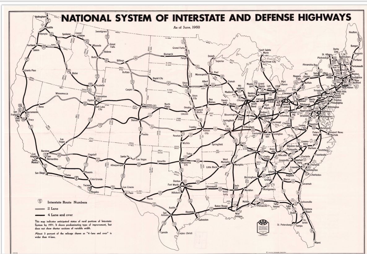
One of the more interesting finds so far is this map by the American Automobile Association (AAA) that shows the planned lane configurations of the original Interstate system. I was amazed by the amount of two lane interstates planned for 1971. 

Interstate 95 in Maine, I-70 in Utah are well known. And over the years I have learned about I-25 in New Mexico and I-91 in North East Vermont but I-81 in South Central PA or I-26 in South Carolina is surprising. Granted, I am looking at it in a modern era, but it is pretty interesting to see.

The AASHTO Route Numbering Archive can be found here.

Comments

Popular posts from this blog

Dillon Road

Dillon Road is a 34.2-mile highway located in northern Coachella Valley of Riverside County, California.  Dillon Road begins at Avenue 48 on the outskirts of Indio and ends to the west at California State Route 62 near San Gorgonio Pass.  Dillon Road was developed the 1930s as a construction road for the Colorado River Aqueduct.  Dillon Road serves as a northern bypass to much of the development of Coachella Valley.  Dillon Road is known for it's frequent dips and spectacular views of San Gorgonio Pass.   Part 1; the history of Dillon Road Dillon Road was constructed as a haul road for the Colorado River Aqueduct through Coachella Valley.  The Colorado River Aqueduct spans 242 miles from Parker Dam on the Colorado River west to Lake Mathews near Corona.  Construction of the Colorado River Aqueduct began during January 1933 near Thousand Palms and was made functional on January 7, 1939.  West of Berdoo Canyon Road the alignment of Dillon Road is largely concurrent with the Colorado

Tehachapi-Willow Springs Road

Tehachapi-Willow Springs Road is an approximately 21-mile highway located in southeast Kern County.  Tehachapi-Willow Springs Road begins at Tehachapi Boulevard (former US Route 466) in Tehachapi and crosses the Tehachapi Mountains via the 4,820-foot-high Oak Creek Pass.  Tehachapi-Willow Springs Road enters Antelope Valley of the wider Mojave Desert and passes by the historic stage station of Willow Springs to a southern terminus at Rosamond Boulevard.  Tehachapi-Willow Springs Road has historic ties to the Havilah-Los Angeles Road and Stockton-Los Angeles Road due to the once reliable presence of water at Willow Springs. Part 1; the history of Tehachapi-Willow Springs Road Oak Creek Pass and Willow Springs were known to the local tribes of the Tehachapi Mountains for generations.  The first documented European crossing of Oak Creek Pass was during 1776 as part of an expedition by Francisco Garces.  Oak Creek Pass is as used again by John C. Fremont during an 1844-1845 expedition to e

The 1928 Iowa Hill Road Bridge

The 1928 Iowa Hill Road Bridge is a derelict structure located in the Sierra Nevada Mountains of Placer County, California.  The 1928 Iowa Hill Road Bridge can be found between the communities of Colfax and Iowa Hill.  The 1928 Iowa Hill Road Bridge is a wire suspension structure which spans the North Fork American River.  The 1928 Iowa Hill Road Bridge was replaced by a modern span and converted to pedestrian use following floods during 1963.   Part 1; the history of the 1928 Iowa Hill Road Bridge During 1853 gold was discovered at what to become Iowa Hill.  The gold mining claims soon led to a small community known as Iowa City being established.   By 1854, Post Office Service began at the mines of Iowa City.  By 1856 gold production at Iowa City was estimated to be around $100,000.  Iowa City was burned in fires during 1857 and 1862 but the community was rebuilt with more modernized structures.   The location of Iowa City can be seen as "Iowa Hill" on the 1873 Bancroft