This past Labor Weekend while returning to the Redding Area from Lassen Volcanic National Park I made a detour onto California State Route 151.

California State Route 151 ("CA 151") is a 7 mile State Highway aligned on Shasta Dam Boulevard in Shasta County. CA 151 connects Interstate 5 in the City of Shasta Lake west to Shasta Dam.

Part 1; the history of California State Route 151
According to CAhighways.org 1939 Legislative Chapter 794 defined a State Highway between from Legislative Route 3/US Route 99 in Shasta City to Shasta Summit. This highway was added to accommodate heavy truck traffic to Shasta Dam. This new highway was not initially given a Legislative Route Number but does appear as Legislative Route 209 ("LRN 209") on the 1940 Division of Highways Map. LRN 209 would not be formalized as a Legislative Route until 1943 Legislative Chapter 964. Note; the 1940 Division of Highways Map shows the LRN 209 ending at the site of Shasta Dam but the road continuing to the site of Kennett on the Sacramento River.


Sacramento Valley and the Sacramento River through much of the 19th Century and early 20th Century was prone to heavy winter floods. A potential solution came in 1919 in the form of the Marshall Plan which was drafted by Robert Marshall and the United States Geological Survey ("USGS"). Marshall and the USGS proposed a proposed a dam near the town of Kennett at a site located downstream from the confluence of the Sacramento River and Pit River. This new dam would serve as a flood control measure and as water storage for irrigation during dry summer months.
The Marshall Plan was proposed in Congress in 1921 but was ultimately rejected as legislation due to the high costs. A less costly variation of the Marshall Plan was drafted by State Engineer Edward Hyatt in 1931 which was known as the State Water Plan. The State Water Plan was essentially the genesis of the Central Valley Project ("CVP") and California State Water Project ("CSWP"). The State of California intended to finance the CVP and CSWP sale of revenue bonds. The State authorized bonds for the CVP (which included Shasta Dam as a key piece) in 1933 but fell short of the funding required due to the Great Depression. The CVP was subsequently authorized in 1935 as one of the many New Deal public works projects.
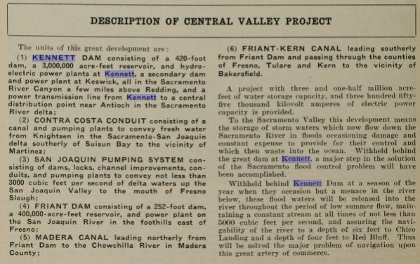
Funding for the Central Valley Project along with it's potential benefits are outlined in the January 1932 California Highways & Public Works.


The March 1932 California Highways & Public Works makes reference to "Kennett Reservoir" as the modern name of "Shasta Lake" had not been yet adopted.


Kennett Dam and Reservoir appear as a conceptual illustration on the September 1933 California Highways & Public Works.


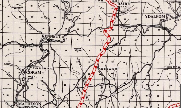
Coram and Kennett can be seen along the Sacramento River on the 1935 Division of Highways Map of Shasta County. In just a couple years the landscape around the confluence of the Sacramento River and Pit River would change forever.
Kennett Dam first appears as Shasta Dam in the October 1937 California Highways & Public Works.

In November 1938 construction of a diversion tunnel at Shasta Dam began so that the foundations could be built. Construction of said foundations at Shasta Dam began in July 1940. Construction of the middle section of Shasta Dam and the spillway began during 1943. Shasta Dam began to impound water into it's reservoir in February 1944 and the last layer of concrete was laid in January 1945. At the time of it's completion Shasta Dam was the second highest in the world only behind Hoover Dam.
Shasta Dam under construction during June of 1942.
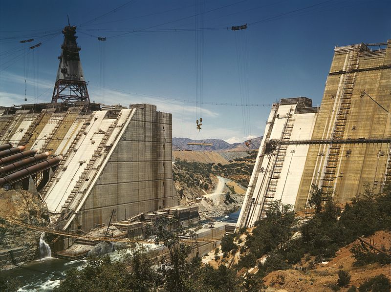
Shasta Dam under construction in March 1943.

Below the town of Kennett can be seen being flooded by the rising waters of Shasta Lake during 1944.

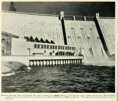
The newly completed Shasta Dam can be seen on the cover of the January/February 1946 California Highways & Public Works.

The same California Highways & Public Works issue details flood control measures at Shasta Dam.


During the 1964 State Highway Renumbering LRN 209 was reassigned as CA 151. CA 151's initial route definition was; from Shasta Dam to Route 5 near Project City. CA 151 first appears on the 1964 Division of Highways State Map.


In 1964 Toyon disbanded and was turned over to the Job Corps. In 1993 the communities of Central Valley, Pine Grove, Project City, and Summit City consolidated into the incorporated City of Shasta Lake. The route definition of CA 151 would change in 2010 to denote that it ended at I-5 in the City of Shasta Lake.
Part 2; a drive on California State Route 151
CA 151 is accessible from I-5 Exit 685.


CA 151 begins with a westward jog from the ramps of I-5. At Postmile SHA 6.802 CA 151 intersects former US 99 at Cascade Boulevard.


CA 151 travels westbound through the Project City neighborhood of Shasta Lake on Shasta Dam Boulevard. Shasta Dam Boulevard splits into a dual one-way configuration from Hardenbrook Avenue west to Ashby Road. From Cascade Boulevard CA 151 is signed as 6 miles from the Shasta Lake Reservoir and is signed as a scenic highway.


At Postmile SHA 5.509 CA 151 crosses under a Union Pacific Railroad underpass.

At Postmile SHA 3.784 CA 151 intersects Sign County Route A18 at Lake Boulevard in the Summit City neighborhood of Shasta Lake.

CA 151 west of Lake Boulevard has a truck length advisory and is signed as 4 miles from Shasta Dam.


CA 151 begins a north/northwest climb to the Shasta Dam Overlook at Postmile SHA 1.287.


CA 151 continues north and terminates at the parking lot for the Shasta Dam Visitor Center.


Comments