
Early in September, Maggie and I took a weekend getaway to Great Smoky Mountain National Park. Neither of us have ever been there and we both wanted to have a getaway weekend before really getting ready for the arrival of Colton in January.
For the entire set on flickr head here.
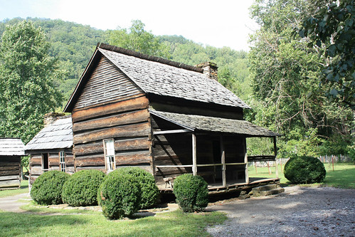
We arrived at the park mid-to-late morning on Saturday, and our first stop was the Ocanuluftee Visitors Center on US 441 at the main North Carolina Entrance to the park. At the visitors center, there is the Mountain Farm Museum which is pretty much a living example of how rural farm life in the Smokies was like in the late 1800 - early 1900s.
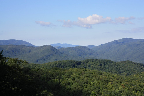
From there, it was the long and winding - yet very scenic drive up Newfound Gap Road (US 441) to Clingman's Dome.
At Clingman's Dome, we registered our first hike in our Hiking the Smokies log book. The log book can be purchased for only $1.00 at any of the park's Visitors Centers - and is worth it. After 100, 250, 500 miles logged. Take your log to a visitor center, and you receive a mileage pin. They also have a Hiking the Smokies for Families log book that reward families at 10, 25, 40 and 50 miles. We were both very excited that we will be able to do this with Colton in later years! For the record our Hiking the Smokies log is at just over five miles from the time we spent at the park. A long way to go to get to the 100 mile pin!
Clingman's Dome is the highest point in Tennessee. The funny thing is you have to park in North Carolina to reach it. The 1/2 mile or so path - because of its popularity - is paved, but it is extremely steep! At the top of the trail, you meet the Appalachian, and also on the North Carolina side Mountains to Sea, Trail.
So technically, Maggie and I added about 1/10th of a mile to our overall Appalachian Trail total of just about zero. But this was Maggie's first time on the Appalachian Trail which she was very excited about!
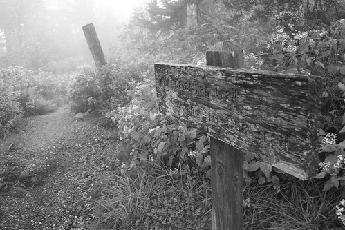
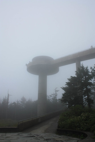
You never know what the weather will be at the top of Clingman's Dome - and at this point it was extremely foggy! The observation tower in the photo below you could make out one minute but the next moment it would be shrouded in a very thick blanket of fog.
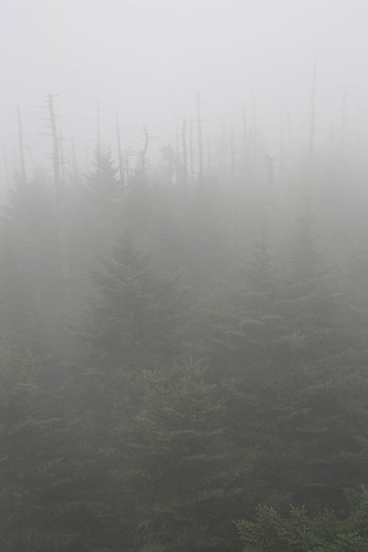
This gives you an example of how foggy it was!
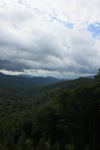
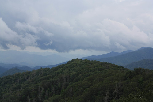
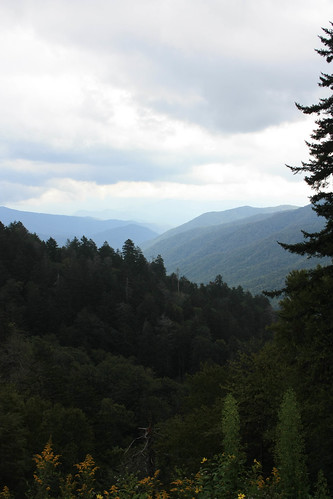
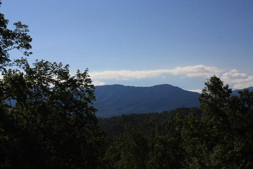
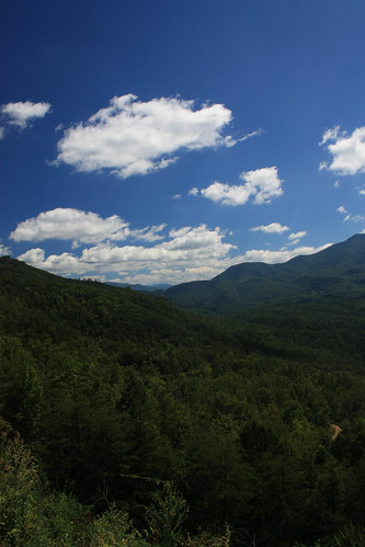
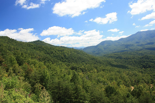
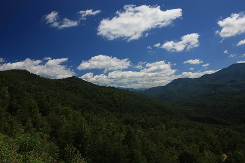
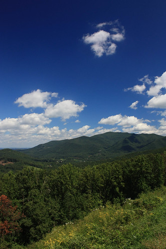
Newfound Gap - our next stop - it was nowhere near as foggy. And we took in some great views as well.

The AT also crosses at Newfound Gap. I don't think these folks are "Thru Hikers" but I'm sure they'd love to make it all the way to Maine.
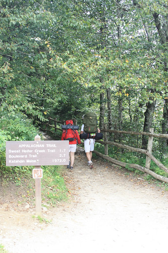
Only 1972.0 miles to go!
From there, it was a picnic lunch and then over to Cades Cove. It was then when the rain joined us for the rest of the day. A steady shower/drizzle was part our two - three hour time at Cades Cove but it still didn't disappoint.
Cades Cove might be the most popular area of the park. The expansive valley surrounded by the Smoky Mountains can be explored by an eleven mile one-way loop that open up to endless possibilites whether it is expansive views, wildlife photography or hiking. From May through September, Cades Cove Loop is only open to bicycles and foot traffic every Wednesday and Saturday morning from sunrise to 10 am. Bike riding the loop is on our to do list.
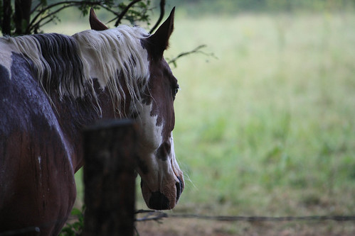
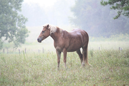
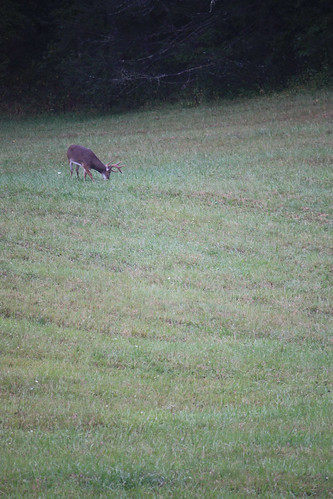
When you travel to and visit the Smokies, everyone seems to ask "Did you see any black bears?" And on this rainy Saturday, we didn't expect to see much. (We were already surprised to see the horses and buck earlier). But just after exiting the Cades Cove Visitor Center, traffic came to a sudden halt and moved slowly. Lo and behold, high up in the tree in the steady rain was a black bear cub. And everyone was stopping to take a look. Including us!
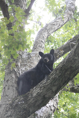
Unfortunately, the rain does not make for the greatest of photographs. But we did see what the park is famous for, and we were asked if we saw any at our lodging that night and elsewhere. This would not be the only time we were fortunate enough to see the wildlife a National Park is famous for this year.
But possibly the best part of our trip was our lodging for the evening. Maggie and I stayed at a lovely Bed & Breakfast - The Quail Ridge Inn. Owned and operated by George and Anita Brewer, the quaint log cabin inn is just amazing. Located outside of the hustle and bustle of Gatlinburg, the ridge top inn offers outstanding views, yet still is close enough to head into Gatlinburg for dinner or to spend the day at the park.
The inn has only three rooms and the hospitality of George and Anita is just top notch! They really make you feel welcome and part of the family. We wish we could have stayed longer!
The rain cleared to clear blue skies on Sunday morning.
After a hearty breakfast at the inn, we headed back to the park to take a ride on the Roaring Fork Motor Nature Trail. The drive of course offered the now-standard stunning views as we headed to the Grotto Falls Trailhead.
We also learned that the earlier that you reach your desire destination the more likely you'll find a parking space and less traffic along the hiking trail.
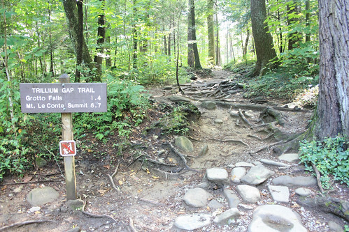
On day, we'll head to LeConte Summit.
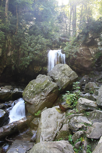
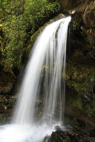
Grotto Falls.
We exited the park and headed home via the Foothills Parkway. The short stretch of the unfinished scenic highway from Cosby to Interstate 40 - only 5.6 miles in length - affords great views similar to that of the Blue Ridge Parkway.
We both really enjoyed our weekend in the Smokies, and we can't wait to go back again. There are so many things to do and a list of outdoor pursuits long enough to cover at least five or six return trips. Rainbow Falls, Mount LeConte, Hiking the AT, Abrams Falls and more are just part of our 'must see and do' list!
For the entire set on flickr head here.
We arrived at the park mid-to-late morning on Saturday, and our first stop was the Ocanuluftee Visitors Center on US 441 at the main North Carolina Entrance to the park. At the visitors center, there is the Mountain Farm Museum which is pretty much a living example of how rural farm life in the Smokies was like in the late 1800 - early 1900s.
From there, it was the long and winding - yet very scenic drive up Newfound Gap Road (US 441) to Clingman's Dome.
At Clingman's Dome, we registered our first hike in our Hiking the Smokies log book. The log book can be purchased for only $1.00 at any of the park's Visitors Centers - and is worth it. After 100, 250, 500 miles logged. Take your log to a visitor center, and you receive a mileage pin. They also have a Hiking the Smokies for Families log book that reward families at 10, 25, 40 and 50 miles. We were both very excited that we will be able to do this with Colton in later years! For the record our Hiking the Smokies log is at just over five miles from the time we spent at the park. A long way to go to get to the 100 mile pin!
Clingman's Dome is the highest point in Tennessee. The funny thing is you have to park in North Carolina to reach it. The 1/2 mile or so path - because of its popularity - is paved, but it is extremely steep! At the top of the trail, you meet the Appalachian, and also on the North Carolina side Mountains to Sea, Trail.
So technically, Maggie and I added about 1/10th of a mile to our overall Appalachian Trail total of just about zero. But this was Maggie's first time on the Appalachian Trail which she was very excited about!
You never know what the weather will be at the top of Clingman's Dome - and at this point it was extremely foggy! The observation tower in the photo below you could make out one minute but the next moment it would be shrouded in a very thick blanket of fog.
This gives you an example of how foggy it was!
Newfound Gap - our next stop - it was nowhere near as foggy. And we took in some great views as well.
The AT also crosses at Newfound Gap. I don't think these folks are "Thru Hikers" but I'm sure they'd love to make it all the way to Maine.
Only 1972.0 miles to go!
From there, it was a picnic lunch and then over to Cades Cove. It was then when the rain joined us for the rest of the day. A steady shower/drizzle was part our two - three hour time at Cades Cove but it still didn't disappoint.
Cades Cove might be the most popular area of the park. The expansive valley surrounded by the Smoky Mountains can be explored by an eleven mile one-way loop that open up to endless possibilites whether it is expansive views, wildlife photography or hiking. From May through September, Cades Cove Loop is only open to bicycles and foot traffic every Wednesday and Saturday morning from sunrise to 10 am. Bike riding the loop is on our to do list.
When you travel to and visit the Smokies, everyone seems to ask "Did you see any black bears?" And on this rainy Saturday, we didn't expect to see much. (We were already surprised to see the horses and buck earlier). But just after exiting the Cades Cove Visitor Center, traffic came to a sudden halt and moved slowly. Lo and behold, high up in the tree in the steady rain was a black bear cub. And everyone was stopping to take a look. Including us!
Unfortunately, the rain does not make for the greatest of photographs. But we did see what the park is famous for, and we were asked if we saw any at our lodging that night and elsewhere. This would not be the only time we were fortunate enough to see the wildlife a National Park is famous for this year.
But possibly the best part of our trip was our lodging for the evening. Maggie and I stayed at a lovely Bed & Breakfast - The Quail Ridge Inn. Owned and operated by George and Anita Brewer, the quaint log cabin inn is just amazing. Located outside of the hustle and bustle of Gatlinburg, the ridge top inn offers outstanding views, yet still is close enough to head into Gatlinburg for dinner or to spend the day at the park.
The inn has only three rooms and the hospitality of George and Anita is just top notch! They really make you feel welcome and part of the family. We wish we could have stayed longer!
The rain cleared to clear blue skies on Sunday morning.
After a hearty breakfast at the inn, we headed back to the park to take a ride on the Roaring Fork Motor Nature Trail. The drive of course offered the now-standard stunning views as we headed to the Grotto Falls Trailhead.
We also learned that the earlier that you reach your desire destination the more likely you'll find a parking space and less traffic along the hiking trail.
On day, we'll head to LeConte Summit.
Grotto Falls.
We exited the park and headed home via the Foothills Parkway. The short stretch of the unfinished scenic highway from Cosby to Interstate 40 - only 5.6 miles in length - affords great views similar to that of the Blue Ridge Parkway.
We both really enjoyed our weekend in the Smokies, and we can't wait to go back again. There are so many things to do and a list of outdoor pursuits long enough to cover at least five or six return trips. Rainbow Falls, Mount LeConte, Hiking the AT, Abrams Falls and more are just part of our 'must see and do' list!

Comments