
MD 33: Easton to Tilghman Island

Maryland 33 Begins

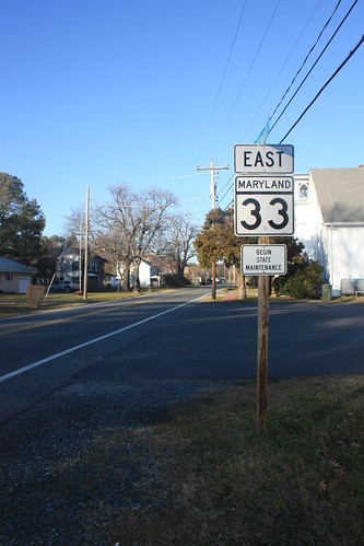
The weekend after I was in Waldorf, Maryland.  The following weekend, I returned to Maryland.  This time to the Eastern Shore and for a Curling Bonspiel at the Chesapeake Curling Club in Easton.  During some downtime between matches, I took a ride out on MD 33 and also MD 579 to check out some of the islands and peninsulas that reach into the Chesapeake.

For the entire Flickr Set - head here.

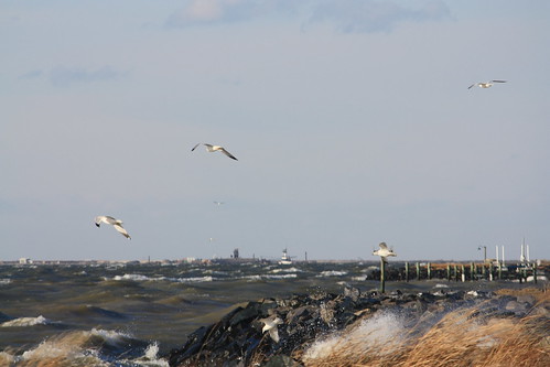
It was an amazingly blustery day - and with the passage of a cold front the night before - it made for some chilly conditions especially when you are trying to take photos from an exposed position on the Chesapeake Bay!

The wind was strong enough that the sea gulls had trouble flying into the headwind!

035

If there was one thing I will remember about Maryland 33 - and Maryland 579 as well - were all of the small rural Methodist chapels.  A lot of the chapels only have service a few times a year - with many of them still advertising their Christmas service - three weeks later.

053

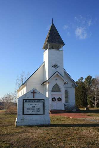
A lot of these rural chapels only have services a few times a year - many of these churches will share one pastor - limiting their ability to have a weekly service.

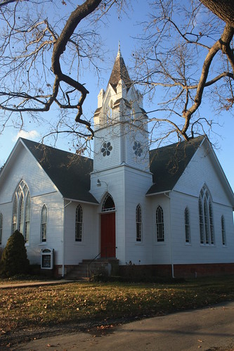
A great example is this church in the town of Sherwood - which is located on an oxbow section of old MD 33.

058

Sherwood United Methodist Church - built in 1912.  The church's next service isn't until March 11th.  The last service was a Christmas Eve Vigil.

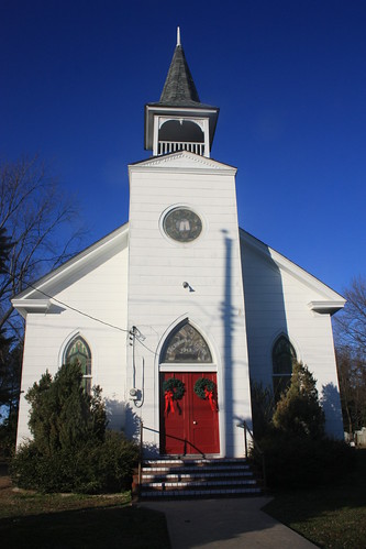
Finally, a trip down MD 579 and in Bozman - a beautiful Methodist Church.

Bozman United Methodist Church

As you can see, the theme of this roadtrip ended up being churches.  Unfortunately, I didn't have time to walk around the charming towns of St. Michael's or Easton.  However, this is just another example of there's plenty to find and discover when your off the main highways and interstates.


Comments

Popular posts from this blog

Abandoned US Route 40 in the Truckee River Canyon

Within the Truckee River Canyon in the Sierra Nevada range numerous abandoned portions of US Route 40 can be found alongside modern Interstate 80.   This segment of highway was opened during 1926 as a bypass of the Dog Valley Grade which carried the early North Lincoln Highway and Victory Highway. The corridor of the Truckee River Canyon State Highway would be assigned as US Route 40 when the US Route System was commissioned during November 1926. During 1958 the segment of Interstate 80 between Boca, California and the Nevada state line was complete. When Interstate 80 opened east of Boca numerous obsolete portions of US Route 40 were abandoned. Some of these abandoned segments have been incorporated into the Tahoe-Pyramid Trail.  Part 1; the history of US Route 40 in the Truckee River Canyon The Truckee River Canyon for centuries has been an established corridor of travel known to native tribes crossing the Sierra Nevada range.  The first documented wagon crossi...

Former US Route 50 and the Pioneer Route Lincoln Highway on Johnson's Pass Road

Johnson's Pass Road is one of the oldest highway corridors in California.  Johnson's Pass was part of the Lake Tahoe Wagon Road as it was completed during 1856 over the Sierra Nevada.  The pass would later be incorporated into the Pioneer Branch of the Lincoln Highway in 1913 and US Route 50 in 1926.  Johnson's Pass Road would be bypassed by a new alignment of US Route 50 over Echo Summit in 1938.  A replacement of the Meyers Grade east of Johnson's Pass would be opened to traffic in 1947.   Johnson's Pass Road remains accessible to traffic and is still signed by the Lincoln Highway Association.  Pictured as the blog cover is the view from the top of Johnson's Pass Road overlooking modern US Route 50 and Lake Tahoe.   Part 1; the history of Johnson's Pass Much of the history of what become the Lake Tahoe Wagon Road is discussed in the  September 1950 California Highways & Public Works  during its Centennial Edition.  The or...

Former California State Route 41 past Bates Station

When California State Route 41 was commissioned during August 1934 it was aligned along the then existing Fresno-Yosemite Road north of the San Joaquin River.  Within the Sierra Nevada foothills of Madera County, the original highway alignment ran past Bates Station via what is now Madera County Road 209, part of eastern Road 406 and Road 207.   Bates Station was a stage station plotted during the early 1880s at what was the intersection of the Coarsegold Road and Stockton-Los Angeles Road.   The modern alignment bypassing Bates Station to the east would be reopened to traffic during late 1939.   Part 1; the history of California State Route 41 past Bates Station Bates Station was featured as one of the many 1875-1899 Madera County era towns in the May 21, 1968, Madera Tribune .  Post Office Service at Bates Station is noted to have been established on November 23, 1883 and ran continuously until October 31, 1903.  The postal name was sourced...