The Bayshore Freeway is a 56.4-mile component of US Route 101 located in the San Francisco Bay Area. The Bayshore Freeway connects the southern extent of San Jose to the Central Freeway in the city of San Francisco. The corridor was originally developed as the Bayshore Highway between 1923 and 1937. The Bayshore Highway would serve briefly as mainline US Route 101 before being reassigned as US Route 101 Bypass in 1938. Conceptually the designs for the Bayshore Freeway originated in 1940 but construction would be delayed until 1947. The Bayshore Freeway was completed by 1962 and became mainline US Route 101 during June 1963.
Part 1; the history of the Bayshore Freeway
Prior the creation of the Bayshore Highway corridor the most commonly used highway between San Jose and San Francisco was El Camino Real (alternatively known as Peninsula Highway). The American El Camino Real began as an early example of a signed as an Auto Trail starting in 1906. The era of State Highway Maintenance on El Camino Real between San Jose and San Francisco would ultimately begin with the 1909 First State Highway Bond Act which was approved by voters in 1910. One of the highways approved through the 1909 First State Highway Bond Act was a 481.8-mile highway originating at the city limits of San Francisco which terminated in San Diego. This highway would ultimately come to be known in time as Legislative Route Number 2 (LRN 2).
Early LRN 2 on El Camino Real between San Jose and San Francisco can be observed on the 1917 California State Automobile Association Map. State maintenance of LRN 2 is shown not exist in the city of San Francisco as the state could not maintain mileage in incorporated cities until 1933.
The origin of the Bayshore Highway would come with 1923 Legislative Chapter 181 which defined LRN 68. The initial definition of LRN 68 directed the California Highway Commission to do the following:
"To layout and construct a highway or highways from the county line separating the city and county of San Francisco in, to, and through the county of San Mateo, as such location or locations as the said California Highway Commission may select."
LRN 68 appears as "San Francisco to Redwood City" on the 1924 California Highway Commission Map. LRN 68 is displayed as a proposed Legislative Act Road which would connect to LRN 2/El Camino Real in Redwood City.
The concept of an extended "Bayshore Highway" (LRN 68) appears in a letter penned by the Palo Alto Times which was published in the
October 1924 California Highways & Public Works. The article speaks of a conference where the proposed extension of the Bayshore Highway was to avoid the city limits of Palo Alto to the east. The article references an early plan which would have had Bayshore Highway connect with Middlefield Road.
1925 Legislative Chapter 471 would extend LRN 68 to San Jose with the following directive for the California Highway Commission:
"To lay out or construct a highway or highways from a point at or near the intersection of Army Street and San Bruno Avenue in the city and county of San Francisco, thence through the county of San Mateo to a point in the city of San Jose in the county of Santa Clara to be selected by the California Highway Commission."
Language was also attached to the extension of LRN 68 which noted the city of San Francisco must pay for their share of the new highway in their jurisdiction.
The December 1925 California Highways & Public Works announced numerous coastal segments of the Bayshore Highway had bridges and tide gates in place as flood control measures.
LRN 68/Bayshore Highway appears on the 1926 California Highway Commission map as a planned highway between San Francisco and San Jose.
During November 1926 the American Association of State Highway Officials (AASHO) would formalize the creation of the US Route System. US Route 101 was overlaid onto LRN 2 along El Camino Real between San Francisco and San Jose. Early US Route 101 can be seen following LRN 2 between San Francisco and San Jose on the 1927 National Map Company Sectional Map.
The December 1927 California Highways & Public Works announced several updates to the Bayshore Highway. The section of Bayshore Highway within San Francisco was slated to be resurfaced with asphalt. A contract had been awarded to surface the existing roadway between South San Francisco and Broadway Station. The opening of a grading contract from Broadway Station to 5th Avenue in San Mateo was about to be advertised by the state.
The April 1928 California Highways & Public Works announced the first unit the state's portion of Bayshore Highway was advertised for contract. The section consisted of a 4.36-mile segment of new highway between San Francisco and South San Francisco. The South San Francisco-Burlingame section of the Bayshore Highway is noted to have been completed without a surface in 1926.
The May/June 1928 California Highways & Public Works announced the Bayshore Highway as complete from South Francisco to San Francisco Airport. A contract to construct the segment between Broadway Station and 5th Avenue in San Mateo is noted to have been awarded.
The July/August 1928 California Highways & Public Works announced surfacing on the Bayshore Highway from South San Francisco to Burlingame. The segment south to 5th Avenue in San Mateo is noted to have a target opening on August 1st.
The September/October 1928 California Highways & Public Works announced construction of remaining 3.5 miles of Bayshore Highway from San Francisco to South San Francisco was underway. The section from Burlingame to San Mateo is noted to have been recently completed.
A letter from the California State Highway Engineer to the AASHO Executive Committee dated April 16, 1929, submitted the split US Route 101W and US Route 101E in the San Francisco Bay area. US Route 101W was to land from Marin County in San Francisco and followed LRN 2/El Camino Real to San Jose. US Route 101E was to land in Oakland and follow LRN 5 south to San Jose. The request planned to consumed part of US Route 48 between Hayward-San Jose. Likewise, a portion of US Route 48 from Mossdale-French Camp was submitted to be repurposed as US Route 99W.
The AASHO Executive Secretary informed the California State Highway Engineer of the approval for the creation of US Route 101W and US Route 101E on April 20, 1929.
The
November 1929 California Highways & Public Works featured the dedication of the completed Bayshore Highway from San Francisco south to San Mateo on October 20, 1929. The article notes that an 11-mile segment of coastal road which predated Bayshore Highway existed along San Francisco Bay as an alternate to El Camino Real. This bay shore road was heavily altered by the construction of a Southern Pacific Railroad cutoff in 1906.
The
same volume also referenced a 7.3-mile contract being advertised to construct the Bayshore Highway from 5th Avenue in San Mateo to Redwood City.
The
March 1931 California Highways & Public Works featured the opening dedication of the Bayshore Highway between San Mateo and Redwood City. The segment is noted to have been dedicated by Governor Rolph on May 14, 1931. The new segment is noted to permit easier access to the Dumbarton Bridge and for traffic to bypass much of the urbanized areas of El Camino Real. An extension of the Bayshore Highway to San Francisquito Creek is noted to be underway.
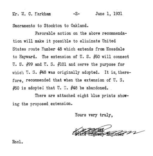
A letter dated June 2, 1931, from the California State Highway Engineer contained an application to the AASHO Executive Commitee to extend US Route 50 to the San Francisco Bay area (via Oakland) and eliminate US Route 48. While not directly stated the request implied the deletion of the East/West branches of US Route 101 in the Bay Area and US Route 99 south of Stockton.
The California State Highway Engineer was informed via telegram on June 12, 1931, that the extension of US Route 50 and elimination of US Route 48 were approved by the Executive Commitee. US Route 101W by proxy reverted to being the singular mainline of US Route 101 in the Bay Area.
The
May 1932 California Highways & Public Works announced the Bayshore Highway had been completed near Sunnyvale Air Base (now Moffett Field). A parade along the new segment was hosted by the Division of Highways to welcome the Naval Dirigible Akron. The article refences coming paving contracts which would see the highway completed from Palo Alto to Lawarence Station Road in Santa Clara County.
Another article in the same volume featured a photo of the complete Bayshore Highway in South San Francisco.
The
July/August 1933 California Highways & Public Works announced the completion of the Bayshore Highway from Oregon Avenue in Palo Alto to Lawarence Station Road in Sunnyvale. The completed corridor was accepted by the state on June 12, 1933. The completed Bayshore Highway is noted to be 35 miles in length and consisted of 40-foot-wide concrete surfacing.
In 1933 the legislative barriers preventing the state from maintaining mileage in incorporated cities was removed. This brought the entirety of Bayshore Boulevard in San Francisco and the routing of US Route 101 under state ownership. LRN 68 was codified in 1935 with the following definition:
1. The Bay Shore Highway from San Francisco to San Jose.
2. The route includes the San Francisco-Oakland Bay Bridge and approaches thereto on the San Francisco End, as those approaches are described in Section 1 of Chapter 9, Statutes of 1933.
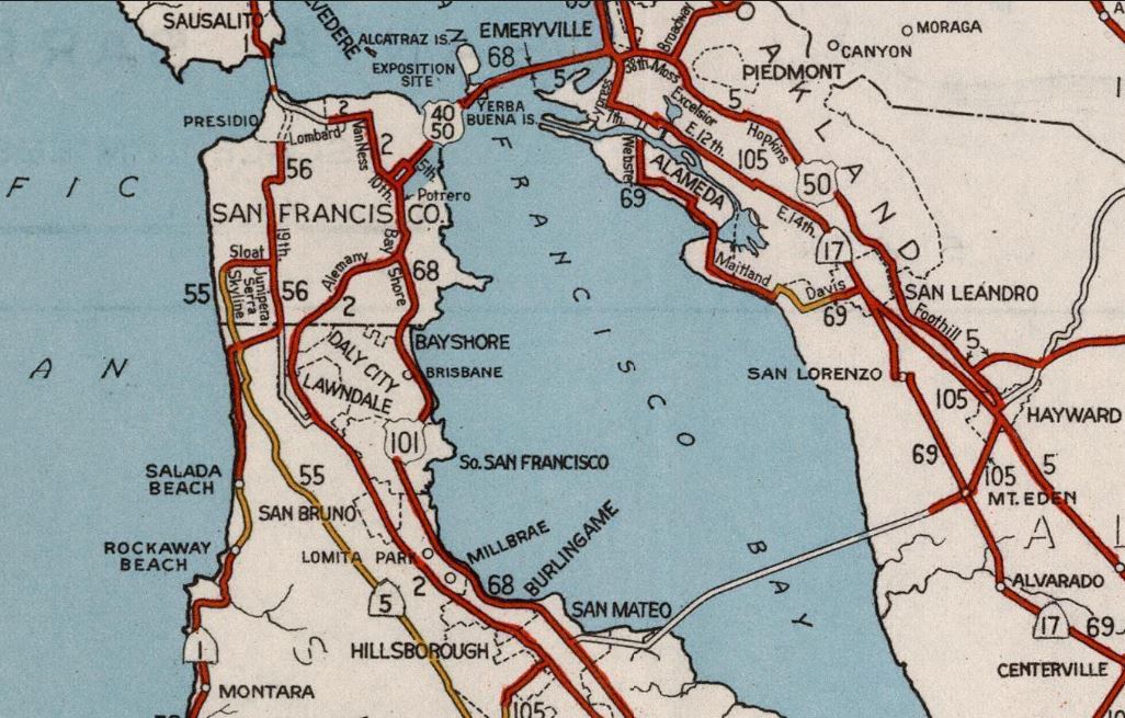
The 1935 Division of Highways Maps of
San Francisco, San Mateo County and Santa Clara County all depict in detail the location of the Bayshore Highway. Within San Francisco, Bayshore Boulevard is shown beginning south of Army Street and branching from US Route 101/LRN 2 at Alemany Boulevard. Bayshore Boulevard is displayed continuing south to the San Mateo County line.
Within
San Mateo County the Bayshore Highway is shown bypassing the urban centers of South San Francisco, Burlingame, San Mateo and Redwood City.
Within
Santa Clara County the Bayshore Highway is shown complete to Lawarence Station Road near Sunnyvale.
The
May 1935 California Highways & Public Works featured the upcoming widening of the Southern Pacific Railroad underpass on the Bayshore Highway in South San Francico. The original underpass was completed in 1927 but was designed in a way that the structure could be widened. A contract to expand the underpass was under bid consideration and the project was expected to be complete during 1936.
A letter dated February 18, 1937, from the California Mission Trails Association to the AASHO Executive Secretary expressed dismay at the recent removal of mainline US Route 101 from El Camino to Bayshore Highway. The view of the association was that the removing mainline US Route 101 from El Camino Real would have a negative impact on the businesses located on LRN 2. The letter requested mainline US Route 101 be restored to El Camino Real and Bayshore Highway instead be assigned as US Route 101 Alternate.
The AASHO Executive Secretary responded to the California Mission Trails Association on March 2, 1937. In the letter the Executive Secretary explained the US Route System was intended to facilitate Interstate travel and that suffixed routes tended to confuse travelers.
A lettered dated July 14, 1937, from the San Jose Clerk of the Council to the AASHO Executive Secretary requested an explanation as to why 4th Street could not be signed as US Route 101 Alternate.
A letter from the AASHO Executive Secretary dated October 28, 1937, acknowledged the intent of the Division of Highways to sign El Camino Real as US Route 101 Alternate. The concept of moving mainline US Route 101 to Bayshore Highway was first proposed by the Division of Highways during August 1935.
The completed Bayshore Highway is depicted as part of mainline US Route 101 on the
1938 Division of Highways Map. LRN 2/El Camino Real is displayed as US Route 101 Alternate. Within San Jose mainline US Route 101 is shown to be concurrent with California State Route 17 on Oakland Road, 13th Street, Santa Clara Street and The Alameda to LRN 2 at Market Street.
A letter from the California State Highway Engineer to the AASHO Executive Secretary dated January 10, 1938, explains the local resistance to mainline US Route being removed from El Camino Real. The letter included a publication from Palo Alto which was critical to the shift of mainline US Route 101 to Bayshore Highway.
The El Camino Real Association sent a letter to the AASHO Executive Secretary dated May 20, 1938, suggesting the restoration of mainline US Route 101 to LRN 2. The letter also suggested signing Bayshore Highway as US Route 101 Bypass. Numerous cities along the routings of El Camino Real and Bayshore Highway were noted to be in concurrence with the El Camino Real Association.
The California State Highway Engineer requested an update to the May 28, 1938, AASHO Executive Committee meeting where the restoration of US Route 101 to El Camino Real and proposed US Route 101 Bypass on Bayshore Highway were discussed.
A letter from the AASHO Executive Secretary dated July 27, 1938, acknowledged US Route 101 had been restored to El Camino Real and the establishment of US Route 101 Bypass.
The city insert of the 1940 map reveals US Route 101 Bypass had been relocated from 13th Street onto the city-maintained 4th Street in San Jose.
The
August 1940 California Highways & Public Works featured the proposed conversion of Bayshore Highway to freeway standards. The freeway conversion was proposed in a California Highway Commission meeting on July 26, 1940. The conversion of Bayshore Highway is cited to be borne out of the explosive population growth patterns in the San Francisco Bay area.
A secondary article in the
same volume details the engineering standards of the proposed Bayshore Freeway.
The
October 1944 California Highways & Public Works announced the California Highway Commission had entered into an agreement with the city of San Francisco to relocate Bayshore Highway at San Francisco Municipal Airport. The agreement signed on September 21, 1944, was part of a postwar program. The new alignment of Bayshore Highway was to be relocated outside the grounds of the expanding airport.
The
January/February 1946 California Highways & Public Works noted three freeway projects along Bayshore Highway were scheduled. The first project consisted of surveys, plans and right of way acquisition from the Bay Bridge ramp at 5th Street in San Francisco to the south city limit. The second project was widening the highway to six lanes from the north city limit of South San Francisco south to the Southern Pacific Railroad underpass. The third project was from the South San Francisco underpass 6.6 miles south to the Peninsula underpass in San Mateo. A fourth unit is noted to be under construction as a new four lane alignment south of Santa Clara Street in San Jose to Ford Road 8.1 miles south.
The
July/August 1947 California Highways & Public Works featured the opening of the Santa Clara Street-Ford Road segment of the Bayshore Freeway. The new freeway segment opened to traffic on June 19, 1947, and connected to mainline US Route 101/LRN 2 at Monterey Highway.
The
same volume featured an update on the Burlingame-San Mateo freeway expansion. In the article the segment is noted to have a new anticipated opening during 1948.
1947 Legislative Chapter 1233 changed the southern end of LRN 68 to "LRN 2 near Ford Road south of San Jose." The paragraph relating to the Bay Bridge was also deleted.
The
1948 Division of Highways Map features the Bayshore Freeway segment between Santa Clara Street and Ford Road. US Route 101 Bypass is shown to be realigned onto 30th Street in San Jose to reach the new freeway segment.
The
May/June 1949 California Highways & Public Works referenced the California Highway Commission authorizing surveys to widen Bayshore Highway to freeway standards on December 30, 1949. The same article features the completed segment (opened on June 28, 1949) of the Bayshore Freeway from near Peninsular Avenue in San Mateo north to the vicinity of Butler Avenue in South San Francisco. The end of the completed segment of freeway north of Butler Avenue tied into Bayshore Highway.
The
May/June 1950 California Highways & Public Works features construction of the first unit of the Bayshore Freeway in San Francisco. The first unit is shown to be in the process of construction from Augusta Street north to 25th Street. The project is noted to include an interchange with mainline US Route 101/LRN 2 at Alemany Boulevard and was expected to be complete by December.
The
1954 Division of Highways Map depicts the newly completed segment of the Bayshore Freeway to Bryant Street in San Francisco. Mainline US Route 101 is shown relocated from Potrero Avenue onto the new freeway segment to Bryant Street. US Route 101 was carried to 10th Street via the Bryant Street ramp.
The completed Bayshore Freeway, Central Freeway and San Francisco Skyline interchange was featured on the cover of the
March/April 1955 California Highways & Public Works. US Route 101 transitioned from the northern of the Bayshore Freeway onto the Central Freeway towards Mission Street. The beginning of the San Francisco Skyline carried US Route 40 and US Route 50 towards the Bay Bridge.
The J
uly/August 1955 California Highways & Public Works noted the Central Freeway opened from the Bayshore Freeway to Mission Street on March 1, 1955. The Bayshore Freeway is noted to have been opened from Alemany Boulevard to 3rd Street on March 30, 1955. The San Francisco Skyway from the Bayshore Freeway to the Bay Bridge is noted to have opened on June 14, 1955.
The
1956 Division of Highways Map displayed the completed Bayshore Freeway, Central Freeway and San Francisco Skyway interchange. US Route 101 is shown to be realigned from the end of the Bayshore Freeway onto the Central Freeway and Mission Street towards Van Ness Avenue.
The
March/April 1956 California Highways & Public Works featured numerous illuminated gantry signs from the Bayshore Freeway.
The
July/August 1957 California Highways & Public Works featured the completed segment of the Bayshore Freeway from 3rd Street in San Francisco over water to Sierra Point. The segment is noted to have opened on Jull 11, 1957. Following the over water segment opening the Bayshore Freeway was completed from San Franisco to southern San Mateo County.
The
May/June 1959 California Highways & Public Works featured the opening of the second segment of the Central Freeway in San Francisco. The 1.4-mile-long segment opened April 22, 1959, between Mission Street to the one-way couplets at Turk Street and Golden Gate Avenue. US Route 101 was realigned onto the extended Central Freeway and connected from the end of the segment to Van Ness Avenue.
The
March/April 1960 California Highways & Public Works announced the Bayshore Freeway/Nimitz Freeway (California State Route 17) Interchange in San Jose was recently completed. The completed portion of the Bayshore Freeway is shown spanning from near Alviso Road to Mabury Road.
The completed Bayshore Freeway/Nimitz Freeway Interchange appears in a Division of Highways travel document dated to September/October 1960. The northbound Nimitz Freeway is shown to be co-signed as California State Route 17 and Interstate 680. The Bayshore Freeway is shown displaying US Route 101 Bypass signage.
1961 Legislative Chapter 1146 changed the north terminus of LRN 68 to "LRN 5 near Oakland" which extended it over the Bay Bridge.
The
March/April 1962 California Highways & Public Works announced the Bayshore Freeway was complete between San Francisco and San Jose. The final traffic light was removed on January 24, 1962, when the Fair Oaks Avenue Overcrossing opened to traffic. The final divided freeway segment opened to traffic February 2, 1962.
On May 1, 1963, the Division of Highways submitted an application to AASHO to eliminate US Route 101 Bypass and relocate the mainline highway onto the Bayshore Freeway. The request was approved by the AASHO Executive Committee on June 19, 1963. El Camino Real was reassigned as
California State Route 82 in the lead up to the 1964 State Highway Renumbering. The 1964 State Highway Renumbering also saw the elimination of the Legislative Route Numbers.
The Bayshore Freeway appears as Mainline US Route 101 whereas El Camino Real is shown as California State Route 82 on the
1964 Division of Highways Map.
In 1982 the southern end of the Bayshore Freeway was realigned when US Route 101 was completed to freeway standards to Gilroy. Originally the Bayshore Freeway ended via a Y-Interchange at Monterey Highway where US Route 101 would continue south. California State Route 82 was realigned from Monterey Highway to Blossom Hill Road where it terminated at US Route 101. The original southern end of the Bayshore Freeway has been since repurposed as part of the Monterey Plaza Shopping Center. The realigned southern end of the Bayshore Freeway can be seen on the 1986 Caltrans Map.
Part 2; a drive on the Bayshore Freeway
The northbound Bayshore Freeway begins in San Jose as US Route 101 approaches California State Route 85 at Exit 377A. Exit 377B accesses Bernal Road, Exit 378 accesses Blossom Hill Road, Exit 380 accesses Hellyer Road, Exit 381 accesses Yerba Buena Road and Exit 382 accesses Capitol Expressway. Our photo tour begins approaching Exit 383 which permits access to Tully Road.
Northbound Exit 384 accesses the modern alignments of Interstate 280 and Interstate 680 whereas Exit 385 accesses Story Road.
Northbound Exit 386A accesses Santa Clara Street and former California State Route 130 at Alum Rock Avenue. Exit 386B accesses McNee Road and Julian Street.
Northbound Exit 388A accesses former California State Route 17/US Route 48 at 13th Street/Oakland Road. Exit 388B and 388C access Interstate 880/Nimitz Freeway.
Northbound Exit 389A accesses Old Bayshore Highway whereas Exit 389B accesses Brokaw Road and 1st Street.
The northbound Bayshore Freeway passes under California State Route 87 and approaches Exit 391. Exit 391 accesses Trimble Road and De La Cruz Boulevard.
The Bayshore Freeway enters the city of Santa Clara. Exit 392 accesses the San Tomas Expressway and Montague Expressway.
Northbound Exit 393 accesses Bowers Avenue and Great American Parkway.
The Bayshore Freeway enters the city of Sunnyvale. Exit 394 accesses the Lawrence Expressway.
Northbound Exit 395 accesses Fair Oaks Avenue.
Northbound Exits 396A and C access California State Route 237.
The Bayshore Freeway enters Mountain View. Exit 397 accesses Ellis Street.
Northbound Exit 398 accesses Moffett Boulevard and NASA Parkway.
Northbound Exit 399A accesses Shoreline Boulevard whereas Exit 399B accesses Old Middlefield Way.
Northbound Exit 400A accesses Amphitheater Parkway. Exit 400B accesses Rengstorff Avenue whereas Exit 400C accesses San Antonio Road.
The Bayshore Freeway enters Palo Alto. Exit 402 accesses Embarcadero Road and Oregon Expressway.
The Bayshore Freeway enters San Mateo County and East Palo Alto. Exit 403 accesses the unsigned California State Route 109 on University Avenue.
Northbound Exit 404 accesses unsigned California State Route 114 on Willow Road.
The Bayshore Freeway enters Menlo Park and picks up westbound California State Route 84 at Exit 406 (Marsh Road).
The Bayshore Freeway enters Redwood City. Westbound California State Route 84 departs from northbound US Route 101 via Exit 408 to Woodside Road.
Northbound Exit 409 accesses Whipple Avenue.
The Bayshore Freeway enters San Carlos. Exit 411 accesses Holly Street and Redwood Shores Parkway.
The Bayshore Freeway enters Belmont. Exit 412 accesses Raiston Avenue and Marine Parkway.
The Bayshore Freeway enters San Mateo. Exit 414A accesses Hillsdale Boulevard whereas Exit 414B accesses California State Route 92 and the San Mateo-Hayward Bridge.
Northbound Exit 415 accesses Kehoe Avenue.
Northbound Exit 416 accesses 3rd Avenue.
Northbound Exit 417A accesses Dore Avenue whereas Exit 417B accesses Peninsular Avenue.
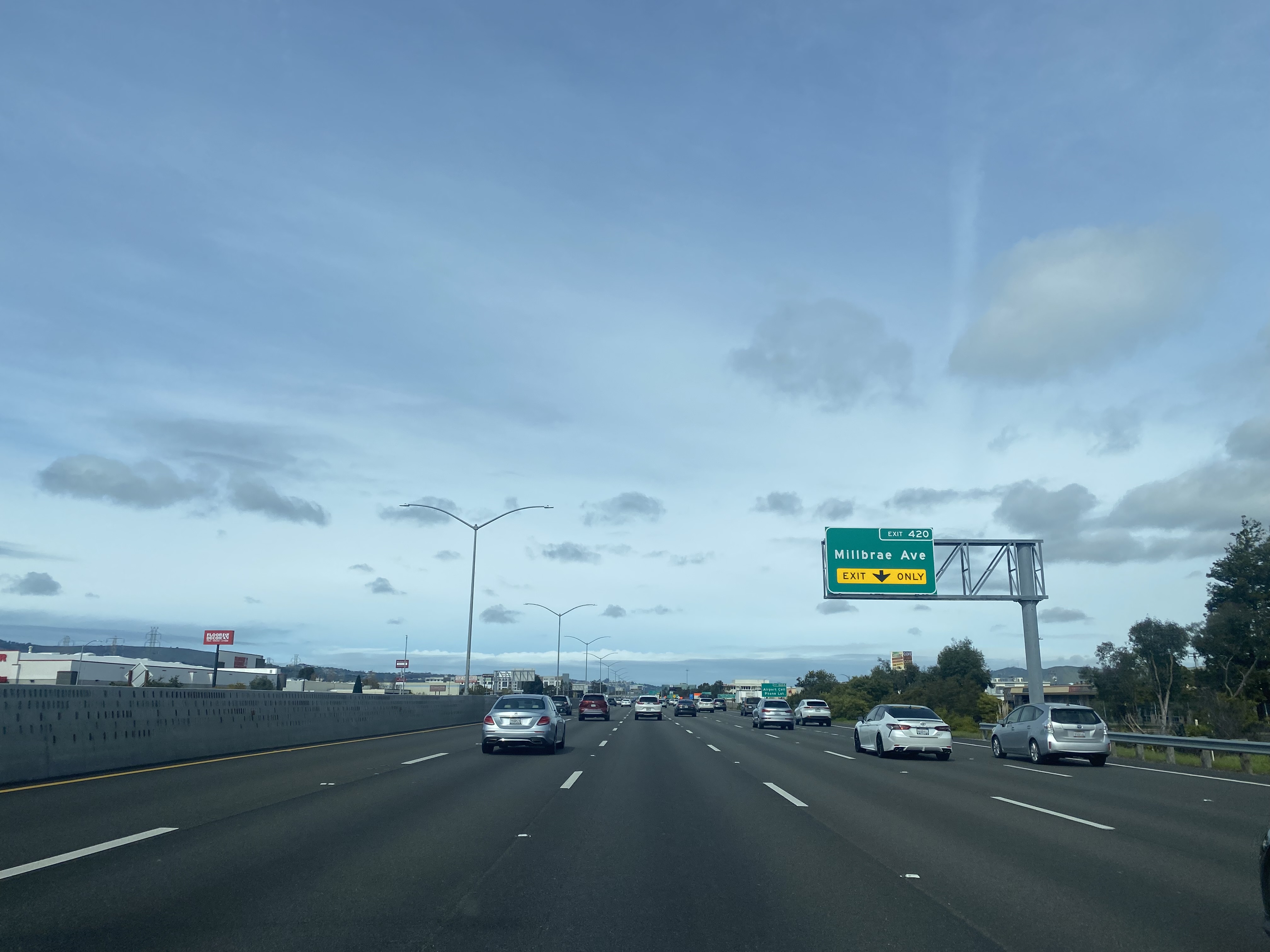
The Bayshore Freeway enters Burlingame. Exit 419A accesses Anza Boulevard whereas Exit 419B accesses Broadway.
Northbound Exit 420 accesses Milbrae Avenue. Approaching the Exit 420 overpass the Bayshore Freeway briefly dips into Milbrae.
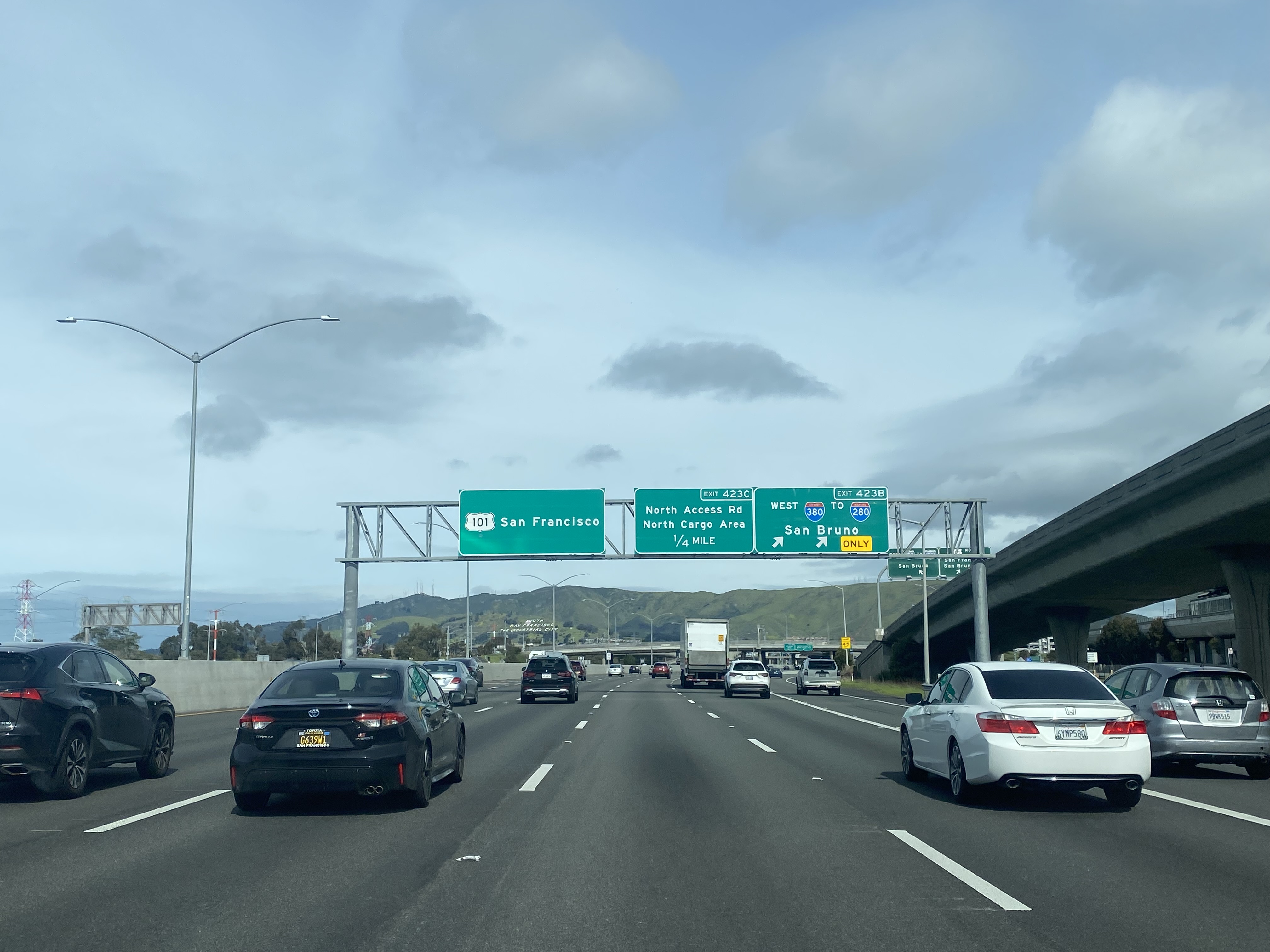
Northbound Exit 422 accesses San Francisco International Airport.
Northbound Exit 423B accesses Interstate 380 whereas Exit 423C accesses North Access Road in the limits of South San Francisco.
Northbound Exit 424 accesses South Airport Boulevard.
Northbound Exit 425A accesses Grand Avenue whereas Exit 425B accesses Oyster Point Boulevard.
Northbound Exit 426A accesses Bayshore Highway and Cow Place. Exit 426B accesses Sierra Point Parkway.
The Bayshore Freeway enters Brisbane and crosses the filled waters of San Francisco Bay from Sierra Point to Candlestick Point. Exit 429A accesses Candlestick Park.
The Bayshore Freeway enters the city and county of San Francisco. As noted in Part 1 the segment in San Francisco is officially designated the James Lick Freeway. Exit 429B accesses 3rd Street whereas Exit 429C accesses Paul Avenue.
Northbound Exit 430A accesses Interstate 280 whereas Exit 430B accesses Silver Avenue.
Northbound Exit 431 accesses Alemany Boulevard and Bayshore Boulevard.
Northbound Exit 432 accesses Cesar Chavez Street (formerly Army Street) and Potrero Avenue.
Northbound Exit 433A accesses Vermont Street.
Northbound Exit 433B accesses the start of eastbound Interstate 80 and the San Francisco Skyway. Exit 433C accesses 9th Street and the San Francisco Civic Center. The Bayshore Freeway terminates as US Route 101 continues north into downtown San Francico via the Central Freeway.


Comments