Eshom Valley Road and Stagecoach Drive are located in the Badger area of the Sierra Nevada Mountains. Both highway corridors are dated to the logging heyday of the Badger area during the nineteenth century. Eshom Valley Road and Stagecoach Drive service traffic accessing Eshom Valley and Hartland Christian Camp. Eshom Valley Road forms an approximately ten-mile loop of Whittaker Forest Road and is designated as Tulare County Mountain Route 469. Stagecoach Drive is a two-mile connector from Dry Creek Road (County Route J21) to Eshom Valley Road. Stagecoach Drive is designated as Tulare County Mountain Route 453.
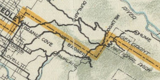
Pictured as the blog cover is Eshom Valley Road entering the grounds of Hartland Christian Camp. Pictured below Eshom Valley Road and Stagecoach Drive can be seen branching east from Badger to Eshom Valley on the
1917 California State Automobile Association Map.
Part 1; the history of Eshom Valley Road and Stagecoach Drive
Prior to the American period the area around what is now Eshom Valley was inhabited largely by the Wukscahe. The Wuksache names for Eshom Valley are reported to include
"Chetatu" and "Clover Place."
The modern name for Eshom Valley is derived from Gold Rush settler John Perry Eshom. John Perry Eshom was from North Carolina and arrived in San Francisco during December 1849. John Perry Eshom worked the mines of Mariposa County and would eventually homestead in the valley which now bears his name. Following the establishment of Post Office service at Badger during 1870 there was numerous encroachments onto the Eshom property. John Perry Eshom would sell his property in Eshom Valley during the 1870s and move to Big Bear area.
Following his departure of John Perry Eshom much of Eshom Valley would be subdivided into numerous parcels. At some point during the late nineteenth century Eshom Valley Road would be constructed from Whittaker Forest Road to connect Eshom Valley to the Badger area. Eshom Valley Road east of Badger (then Camp Badger) can be seen on the
1892 T.H. Thompson Atlas of Tulare County in Township 15S, Range 27E and
T15S, Range 28E. Eshom Valley Road can be seen ending at the Moore property in Eshom Valley immediately east of the Dry Creek Schoolhouse.
Bill Hart's property can be seen along Eshom Creek north of Eshom Valley on 1892 Thompson Atlas in Township 15S, Range 28E.
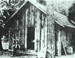
Bill Hart established his sawmill along Eshom Creek at Clipper Flat during the logging boom of the Badger area. Bill Hart owned 320 acres of land north of Eshom Valley and would eventually relocate his mill to Dark Canyon. Below Bill Hart's logging cabin can be seen in an undated photo from the late nineteenth century on Welcome to Eshom Valley.
Stagecoach Drive appears on the 1905 United States Geological Survey Map of the Tehipite area. The map also depicts what is now Cemetery Drive connecting from Eshom Valley Road north to Hart's Sawmill. Cemetery Drive no longer is passable north of Eshom Valley.
Eshom Valley Road and Stagecoach Drive can be seen branching east from the Badger area to Eshom Valley on the 1917 California State Automobile Association Map.
By 1920 Bill Hart began to subdivide his property and began survey a connecting road from Eshom Valley. The first lots at Hart's property at Clipper Flat sold during 1921. Eshom Valley Road can be seen extended from Eshom Valley northeast to what is now Pierce Valley Drive on the 1935 Division of Highways Map of Tulare County. No road directly connecting Pierce Valley Drive north to Whittaker Forest Road along Eshom Creek is displayed as being present.
During October 1945 the Millwood Christian Association purchased 80 acres of Bill Hart's property at Clipper Flat. The association had originally intended to develop a camp around the former logging grounds of Millwood but could not find a suitable property. The association changed board changed their name to the "Hartland Christian Association" in reference to the new camp being located on what was Bill Hart's property.
Eshom Valley Road was extended from Pierce Valley Road to Whittaker Forest Road following the establishment of Hartland Christian Camp. The connection from Hartland Christian Camp to Whittaker Forest Road was critical due to the once proposed reservoir which would have flooded Eshom Valley. The proposed reservoir at Eshom Valley was planned to be filled with water diverted from the North Fork Kaweah River. The Eshom Valley Reservoir was planned as part of the outgrowth of the Terminus Dam project by the Army Corps of Engineers.
Modern Eshom Valley Road appears as a loop of Whittaker Forest Road on the 1956 United States Geological Survey Map of the Giant Forest. Cemetery Road north of Eshom Valley Cemetery is shown to be abandoned. Eshom Valley itself is also shown as a proposed reservoir.
Part 2; a drive on Stagecoach DriveStagecoach Drive eastbound begins from a fork in the road along Tulare County Route J21 (Dry Creek Road). As Stagecoach Drive begins it is signed as 9 miles from Hartland Christian Camp (Hartland).
Stagecoach Drive eastbound descends into Dry Valley and crosses a bridge over Dry Creek.
Stagecoach Drive eastbound passes through Dry Valley and the small community of Sierra Lakes. Stagecoach Drive terminates at Eshom Valley Road.
Part 3A; a drive on Eshom Valley Road from Stagecoach Drive to Hartland Christian Camp
From the eastern terminus of Stagecoach Road traffic continuing onto eastbound Eshom Valley Road is advised that Hartland is 7 miles away.
Eshom Valley Road east of Stagecoach Drive climbs from Dry Valley to Eshom Valley. Eshom Valley Road upon entering Eshom Valley intersects Cemetery Road. Eshom Valley lies at an approximate elevation of 3,300 feet above sea level.
Pictured is the view northward along Cemetery Road towards Eshom Valley Cemetary. As noted in Part 1 Cemetery Road once continued north of Eshom Valley to Bill Hart's Sawmill at Clipper Flat.
Eshom Valley Road climbs from Eshom Valley and turns northward. Eshom Valley Road ascends through a series of hairpins and switchbacks to the Eshom OHV Staging Area at Pierce Valley Drive.
Eshom Valley Road is signed as being 1 mile from Hartland at Pierce Valley Drive.
Eshom Valley Road enters the grounds of Hartland Christian Camp which is located at approximately 4,700 feet above sea level along Eshom Creek.
Eshom Valley Road passes through the grounds of Hardland Christian Camp and terminates at Whittaker Forest Road (Tulare County Mountain Route 465). The last two miles of Eshom Valley Road beyond Hartland Christian Camp were damaged during the winter of 2023.
Part 3B; a drive on Eshom Valley Road from Stagecoach Road to Whittaker Forest Road
Traffic approaching Stagecoach Road from westbound Eshom Valley Road is notified that Badger can accessing by staying on the latter.
Eshom Valley Road passes though Dry Valley and crosses over Dry Creek.
Eshom Valley Road climbs from Dry Valley and passes through the small community of Sierra Glen before terminating at Whittaker Forest Road approximately 1 mile from Badger.


Comments