
The original California State Route 14 was one of the initial Sign State Routes defined during August 1934 and was located in the Los Angeles Metropolitan area. The original California State Route 14 began at California State Route 3 (later US Route 101A) near Hermosa Beach and ended at California State Route 18 at Santa Ana Canyon. The early freeway segments of California State Route 14 east of Anaheim would be multiplexed with US Route 91 and California State Route 18 during the 1950s. California State Route 14 would ultimately be replaced by California State Route 91 in 1964. The original California State Route 14 is associated with the history of the Gardena Freeway, Artesia Freeway and Riverside Freeway. California State Route 14 can be seen on Artesia Boulevard approaching California State Route 19 at Lakewood Boulevard during 1953 as the blog cover photo. California State Route 14 can be seen below as a partially completed Legislative Route Number 175 on the 1938 Division of Highways Map.

The history of the original California State Route 14
What was to become the original California State Route 14 was defined as Legislative Route Number 175 (LRN 175) by way of 1933 Legislative Chapter 767. LRN 175 was originally defined as follows:
"LRN 60 near Hermosa Beach to LRN 43 in Santa Ana Canyon via Artesia Ave."
LRN 175 can be seen for the first time on the 1934 Division of Highways Map.

The August 1934 California Highways & Public Works announced the initial run of Sign State Routes. Said volume announced the entirety of LRN 175 was assigned as California State Route 14.

California State Route 14/LRN 175 appears in detail on the 1935 Division of Highways Maps of Los Angeles County and Orange County. The highway is shown to begin eastbound at California State Route 3/LRN 60 near Hermosa Beach via Aviation Boulevard, Redondo Beach Boulevard and 174th Street. A gap in the highway is shown beginning at Normandie Avenue near the Los Angeles city limit to the Pacific Electric Railway south of Compton. From the Pacific Electric Railway, the highway is displayed following Artesia Boulevard east to the Orange County line.

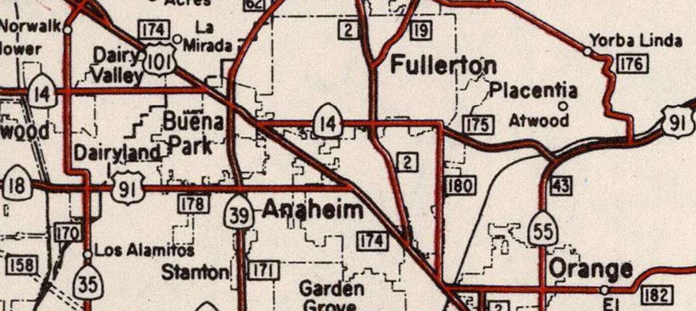
Within Orange County eastbound California State Route 14/LRN 175 is shown following Artesia Boulevard, California State Route 39/LRN 62 on Grand Avenue, Orangethorpe Avenue and the Yorba Bridge over the Santa Ana River to California State Route 18/LRN 43.

The 1936-37 Division of Highways Map displays the western terminus of California State Route 14/LRN 175 being realigned onto Redondo Beach Boulevard.

The May 1937 California Highways & Public Works discusses the opening the final segment of the "Manchester Boulevard Extension" which was dedicated on April 30, 1937. The Manchester Boulevard Extension provided a direct link between Downey and Anaheim which followed the Southern Pacific Railroad. The Manchester Boulevard Extension bypassed downtown Anaheim and tied into existing alignment of California State Route 10/LRN 174 on southern Manchester Boulevard at Miraflores near the outskirts of Santa Ana. The Manchester Boulevard Extension is stated to have been conceptualized during 1924 by the Greater Manchester Avenue Improvement Association. The Manchester Boulevard Extension concept was taken over by the Division of Highways when LRN 174 was added as a State Highway circa 1933. California State Route 14 was realigned onto a multiplex of California State Route 10 on the Manchester Boulevard Extension between Artesia Boulevard and Orangethorpe Avenue.


The February 1939 California Highways & Public Works announced 5 miles of California State Route 14/LRN 175 east of Normandie Avenue was budgeted for construction during the 91st/92nd Fiscal Year.

California State Route 14/LRN 175 appears complete for several miles in both directions of Avalon Boulevard along a new segment of Artesia Boulevard on the 1940 Division of Highways Map.

On July 1, 1947, the AASHO Executive Secretary notified the California State Highway Engineer that California's request to extend US Route 91 from Barstow to Long Beach had been approved. The extension of US Route 91 to Long Beach initially brought it through Anaheim along Center Street via a multiplex of California State Route 18/LRN 178.


The July/August 1953 California Highways & Public Works announced the standardization of California State Route 14/LRN 175 along Artesia Boulevard over a 6.25-mile corridor. The improvements to Artesia Boulevard were completed over three contracts which widened the highway to four lane standards and incorporated the existing Los Angeles River Bridge. California State Route 14 west of Alameda Street is shown to be under construction. The segment of highway between Alameda Street to Central Avenue was to include three bridges over the Pacific Electric Railway.


The September/October 1954 California Highways & Public Works provided an update to the ongoing conversion of California State Route 14/LRN 175 on Artesia Boulevard to four lane standards. The article is one of the first overt references to Redondo Beach Boulevard and 174th Street as part of the greater Artesia Boulevard corridor. The article notes two new contracts had been let to construct the gap in Artesia Boulevard east of the Redondo Beach area which were expected to be complete by 1955. The article features numerous photos of the newly widened California State Route 14 around Redondo Beach.


The January/February 1955 California Highways & Public Works announced the entirety of California State Route 14/LRN 175 from Normandie Avenue had been adopted by the California Highway Commission as the planned "Artesia Freeway."


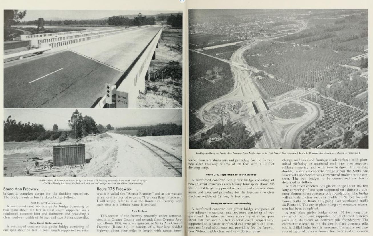
The July/August 1955 California Highways & Public Works featured construction of US Route 101 along the Santa Aana Freeway south of Anaheim and the Route 175 Freeway (California State Route 14) east of LRN 180 to LRN 43. The Santa Ana Freeway between 1st Street and Browning Avenue near Santa Ana/Tustin is cited to be 70% complete. The Route 175 Freeway is noted to referenced locally as the "Orangethorpe Freeway" and approximately 50% complete. The planned Route 175 Freeway west of US Route 101 is referenced as the "Artesia Freeway" and "Hermosa Beach Freeway."


US Route 91 and California State Route 18 appear realigned onto California State Route 14/LRN 175 on the 1956 Division of Highways Map north of downtown Anaheim. The interim routing of US Route 91/California State Route 18 from Lincoln Avenue followed US Route 101/Manchester Boulevard, Orangethorpe Avenue, Cypress Avenue (now State College Boulevard) and a completed segment of the Orangethorpe Freeway (east of LRN 180).

The gap on California State Route 14/LRN 175 east of Normandie Avenue is shown complete on the 1956 Division of Highways Map.

The March/April 1956 California Highways & Public Works announced the Artesia Freeway of California State Route 14/LRN 175 had been recently complete from Normandie Avenue east to Main Street. A second segment from Central Avenue to Santa Fe Avenue was expected to complete during Spring.


The July/August 1956 California Highways & Public Works featured the opening of the Houston Expressway (California State Route 14/US Route 91/California State Route 18/LRN 175) east of LRN 180/Cypress Avenue to Santa Ana Canyon. An opening ceremony was held in Anaheim, but the article does not specify a date.

The 1957 Division of Highways Map displays California State Route 18 and US Route 91 realigned onto the Stanton Avenue Extension along California State Route 39/LRN 171 in Buena Park. Both highways briefly multiplexed US Route 101 towards California State Route 14/LRN 175 on Orangethorpe Boulevard.
The January/February 1958 California Highways & Public Works announced the Houston Expressway had been renamed the "Riverside Freeway" by the California Highway Commission on October 25, 1957. The Riverside Freeway corridor was defined as from the Santa Ana Freeway was to Riverside. The article is one of the first overt references to both US Route 91 and California State Route 18 both being present on the completed portions of the Riverside Freeway. The article notes a segment of the Riverside Freeway from the Santa Ana Freeway east to LRN 2 at Spadra Avenue was under construction.


The January/February 1959 California Highways & Public Works references the Santa Ana Freeway being completed through Buena Park during the previous year. The same volume references the Riverside Freeway from the Santa Ana Freeway east to LRN 2/Spadra Avenue as also being completed during 1958. An extension of the Riverside Freeway to Placentia Avenue is cited to be underway.


The 1959 Division of Highways Map displays the gap on the Riverside Freeway between LRN 2/Spadra Avenue and Placentia Avenue.

The January/February 1960 California Highways & Public Works announced the Riverside Freeway between LRN 2/Spadra Avenue in Fullerton to Placentia Avenue in Anaheim opened on November 18, 1959.


The January/February 1960 California Highways & Public Works announced that the alignment of the Artesia Freeway between Alameda Street and Palo Verde Avenue had been adopted by the California Highway Commission on February 18, 1959.


The Riverside Freeway east of the Santa Ana Freeway to Santa Ana Canyon appears complete on the 1960 Division of Highways Map.

The 1962 Division of Highways Map displays California State Route 18 truncated from Long Beach to San Bernardino. The truncation of California State Route 18 removed it from US Route 91/California State Route 14/LRN 175 on the Riverside Freeway north of downtown Anaheim.

US Route 91 was requested by the Division of Highways to be truncated to Barstow during 1963. The truncation of US Route 91 to Barstow appears in a letter written by the State Highway Engineer to the AASHO Executive Secretary dated August 26, 1963.


As part of the 1964 State Highway Renumbering the corridor of the Riverside Freeway and Artesia Freeway was consolidated into the newly designated California State Route 91. The California State Route 14 designation was recycled into a new routing which comprised what was US Route 6 from Newhall Pass-US Route 395 and the planned Reseda Freeway. The initial definition of California State Route 91 was as follows:
"Route 1 near Hermosa Beach to Route 395 via Santa Ana Canyon."
California State Route 91 appears on the 1964 Division of Highways Map following Artesia Avenue, the completed segments of the Artesia Freeway and Riverside Freeway.


The 1964 Highway Renumbering also defined the segment of former US Route 91 and California Route 18 from California State Route 19 to Interstate 5 as "California State Route 214." 1965 Legislative Chapter 1372 added a stipulation to the definition of California State Route 214:
"This route shall cease to be a state highway when Route 91 freeway is completed from Route 19 to Route 5 and the commission relinquishes that portion of present Route 91 from Route 19 to Route 5."
The March/April 1964 California Highways & Public Works announced that construction on the Artesia Freeway east from Alameda Street to the Santa Ana Freeway was to be constructed in five segments beginning in the 1965-66 Fiscal Year. Completion of the Artesia Freeway east of Alameda Street is noted to have an expected completion during 1970. The existing portion of the Artesia Freeway between Normandie Avenue and Alameda Street is noted to be expressway grade which was expected to be completed to full freeway standards within six/seven years. The existing expressway grades of the Riverside Freeway near Anaheim and Placentia are noted to have planned freeway conversions. The Riverside Freeway was expected to reach Riverside County by 1970.


The California Highways & Public Works publication ended in 1967. The 1967 Division of Highways Map displays the unconstructed adopted segments of the Artesia Freeway west of the Santa Ana Freeway.

The 1969 Division of Highways Map displays the Artesia Freeway completed between California State Route 19 east to Cerritos.

The 1970 Division of Highways Map displays the Artesia Freeway complete from Cerritos to the Santa Ana Freeway. The Artesia Freeway is shown to be under construction from California State Route 19 west to California State Route 7 (the Long Beach Freeway). The Riverside Freeway is shown to under construction in the Yorba Linda area.

1970 Assembly Concurrent Resolution, Chapter 148 officially named California State Route 91 the "Artesia Freeway" between California State Route 7 east to the Santa Ana Freeway (Interstate 5). It isn't clear but the same legislative act may have also renamed the segment of California State Route 91 west of California State Route 7 as the "Redondo Beach Freeway."
The 1975 Caltrans Map displays the Artesia Freeway was complete between California State Route 19 and California State Route 7. The Riverside Freeway is shown as complete in the Yorba Linda area. The Redondo Beach Freeway would be completed to Wilmington Avenue along with the Long Beach Freeway interchange by 1974. The unadopted extension of the Redondo Beach Freeway through Torrance and Hermosa Beach was cancelled by Caltrans also during 1974. This cancellation came after the Torrence city council voted on a resolution against the Redondo Beach Freeway and Torrance Freeway.

The 1977 Caltrans Map displays the Redondo Beach Freeway complete aside from the existing expressway segment between Normandie Avenue and Alameda Street which intersected the Harbor Freeway (California State Route 11). The Riverside Freeway is shown complete to the city of Riverside. 1977 Legislative Chapter 919 changed the eastern terminus of California State Route 91 to California State Route 194 (the secret legislative designation of Interstate 15E).

The stipulation set by 1965 Legislative Chapter 1372 was acted upon as part of 1981 Legislative Chapter 292 which deleted California State Route 214 from the State Highway System. 1982 Legislative Chapter 681 would change the eastern terminus of California State Route 91 to "Route 215" to reflect Interstate 15E being renumbered to Interstate 215.
Work on the Redondo Beach Freeway/Harbor Freeway interchange had been halted in 1975 due to budget shortfalls. Work would resume during the early 1980s and the interchange would be complete during June 1985. The Redondo Beach Freeway is displayed as ending at the Harbor Freeway (now Interstate 110) on the 1986 Caltrans Map. The Redondo Beach Freeway would be renamed as the "Gardena Freeway" by way of 1991 Senate Concurrent Resolution 16, Chapter 35.

1999 Assembly Bill 1650, Chapter 724 permitted the relinquishment of California State Route 91 along Artesia Boulevard between California State Route 107 and California State Route 1 if the cities involved would agree to accept the segments of Artesia Boulevard. California State Route 91 was relinquished in Redondo Beach during 2001 which was followed by Lawndale in 2002. With the last remaining vestiges of the original California State Route 14 along Artesia Boulevard relinquished the legislative definition of California State Route 91 was amended by way of 2003 Assembly Bill 1717, Chapter 525 to begin at the eastern city limit of Gardena.
The modern alignment of California State Route 91 appears on the 2005 Caltrans Map.

Comments