
Maggie and I headed up to Pennsylvania for the Fourth of July. We headed up on a Thursday and spent about three hours at Sky Meadows State Park in Paris, Virginia for lunch and some hiking.
Route: NC 50, US 15, I-85, I-95, US 17, I-81, VA 37, US 522, I-68, US 40, PA 51, PA 48.
For years, I have wanted to stop and check out Sky Meadows State Park. Sky Meadows is located on the two lane stretch of US 17 that runs between US 50 and Interstate 66. Though only ten miles in length, this is a highly scenic and enjoyable drive. (Do watch your speed and keep your eye out for equestrians along the shoulder of the road.)
For the entire flickr set from Sky Meadows - head here.
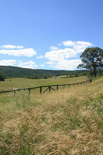
After a lunch, we decided to take some time hiking some of the trails at the park. Sky Meadows has over 12 miles of hiking trails, and the park includes nearly two and a half miles of the Appalachian Trail. We weren't able to reach the AT; however, we did hike the Piedmont Overlook Trail and parts of the North Ridge Trail.
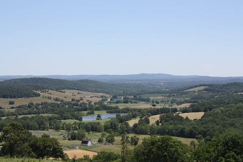
The Piedmont Overlook Trail is a little steep but the views are well worth it!
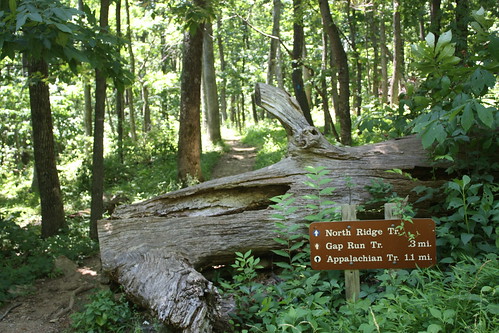
The North Ridge Trail in its entirety runs just over one and a half miles and leads to the Appalachian Trail. One of the impressive parts of the trails, at least to Maggie and I, were how well marked they were. You knew what trail you were on, what trails you were intersecting, and how far to the next trail or landmark. This was the first hiking trip we've done at a Virginia State Park, so I am not sure if this is consistent throughout their parks, but if it is, it makes for a more pleasant hiking experience.
We would loved to have been able to continue the mile or so to the AT, but we still had over three and a half hours of driving to do.
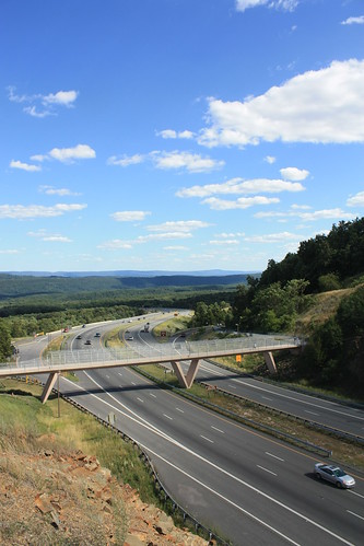
Speaking of the drive from Sky Meadows to Pennsylvania, we stopped at the Sideling Hill Overlook/Rest Area on I-68 near Hancock, Maryland. Though the visitor's center is now closed, the rest area is still a popular stop because of its spectacular views.
So what's in store for Day 2? I hope you like Roller Coasters!
Route: NC 50, US 15, I-85, I-95, US 17, I-81, VA 37, US 522, I-68, US 40, PA 51, PA 48.
For years, I have wanted to stop and check out Sky Meadows State Park. Sky Meadows is located on the two lane stretch of US 17 that runs between US 50 and Interstate 66. Though only ten miles in length, this is a highly scenic and enjoyable drive. (Do watch your speed and keep your eye out for equestrians along the shoulder of the road.)
For the entire flickr set from Sky Meadows - head here.
After a lunch, we decided to take some time hiking some of the trails at the park. Sky Meadows has over 12 miles of hiking trails, and the park includes nearly two and a half miles of the Appalachian Trail. We weren't able to reach the AT; however, we did hike the Piedmont Overlook Trail and parts of the North Ridge Trail.
The Piedmont Overlook Trail is a little steep but the views are well worth it!
The North Ridge Trail in its entirety runs just over one and a half miles and leads to the Appalachian Trail. One of the impressive parts of the trails, at least to Maggie and I, were how well marked they were. You knew what trail you were on, what trails you were intersecting, and how far to the next trail or landmark. This was the first hiking trip we've done at a Virginia State Park, so I am not sure if this is consistent throughout their parks, but if it is, it makes for a more pleasant hiking experience.
We would loved to have been able to continue the mile or so to the AT, but we still had over three and a half hours of driving to do.
Speaking of the drive from Sky Meadows to Pennsylvania, we stopped at the Sideling Hill Overlook/Rest Area on I-68 near Hancock, Maryland. Though the visitor's center is now closed, the rest area is still a popular stop because of its spectacular views.
So what's in store for Day 2? I hope you like Roller Coasters!
Comments