US Route 60 and US Route 70 were 1930s era additions to the US Route System within Southern California. Both US Route 60 and US Route 70 were both major transcontinental highways which spanned the width of the United States at their maximum extent. This blog features the alignment history of US Route 60 and US Route 70 from Los Angeles east to Pomona. Featured as the blog cover is US Routes 60-70-99 on a recently completed segment of the San Bernardino Freeway in West Covina.
The history US Route 60 and US Route 70 in the Los Angeles-Pomona corridor
As originally envisioned in the early drafts of US Route System what became US Route 66 in California was intended to be US Route 60. The designation of the Chicago-Los Angeles corridor was intended to carry a X0 route number given it was to denote a major east/west US Route. Ultimately the State of Kentucky petitioned to have a X0 US Route and the Chicago-Los Angeles corridor became US Route 66 in the finalized US Route System created by the American Association of State Highway Officials (AASHO) during November 1926.
US Route 60 (US 60) would rapidly be extended after the US Route System was created and would come into play in California during the early 1930s. A letter from the AASHO Executive Secretary to the California State Highway Engineer dated Marth 30th, 1931 noted that US 60 had been tentatively approved to be extended to California during the AASHO Executive Committee on May 26th, 1930. The approval of US 60 being extended to California carried the stipulation that the Colorado River Bridge in Blythe be purchased by the California Division of Highways and Arizona State Road Department. The letter noted California and Arizona had taken steps through their respective legislatures to purchase the Colorado River Bridge and the terminus of US 60 to be at an undisclosed location in Los Angeles.


A letter from the California State Highway Engineer to the AASHO Executive Secretary on April 13th, 1931, noted legislation to purchase the Colorado River Bridge had been passed in California. The purchase of the Colorado River Bridge effectively made the extension of US 60 into California active.
The California State Highway Engineer submitted a recommended routing of US 60 to the AASHO Executive Secretary on September 8th, 1931. The route description of US 60 show as ending in Los Angeles by way of Pomona at an undisclosed terminus.
The AASHO Executive Secretary advised the California State Highway Engineer in a letter dated June 22nd, 1932, that the way points of US 60 in California were approved by the AASHO Executive Committee. US 60 was to follow
Legislative Route Number 26 (LRN 26) from Pomona to the Los Angeles city limit to an undisclosed terminus in the city. LRN 26 had been extended by the State Legislature during 1931 from Colton to Los Angeles via Pomona. Prior to 1933 the Division of Highways could not maintain highway mileage within incorporated cities.

State Maintenance of LRN 26 and US 60 was extended to downtown Los Angeles to Aliso Street during 1933 upon the California State Legislature permitting the Division of Highways to maintain mileage within incorporated cities. A series of September 1934, letters by the California State Highway Engineer to the American Association of State Highway Officials (AASHO) Executive Secretary noted a recommendation to move US 99 from Los Angeles to Redlands via LRN 26 through Pomona and Colton. The California State Highway Engineer noted traffic on US 99 would be better served traversing downtown Los Angeles and utilizing US 60/LRN 26 directly to reach Redlands. Notably the alignment the sketch map provided by the California State Highway Engineer shows existing US 99 following San Fernando Road to US 66 at Arroyo Seco Avenue and a multiplex on US 66/LRN 165 via Figueroa Street to Colorado Boulevard.
The same exchange of letters also notes US 70 had been extended into California with an endpoint following US 60/LRN 26 into downtown Los Angeles. The routing definition of US 70 indicated it would multiplex US 99/US 60 east from downtown Los Angeles to Pomona and onwards to US 60 east to Beaumont.
The 1
934 Division of Highways City Insert implies US 60/LRN 26 followed an interim alignment from downtown Los Angeles eastward following Macy Street, Mission Street, Alhambra Avenue and Valley Boulevard towards Pomona. The planned Ramona Expressway can be seen as a dotted line connecting Macy Street directly to Garvey Avenue.
The
1934 Division of Highways Map shows LRN 26 following Garvey Avenue from Monterey Park onto Arroyo Avenue, Holt Avenue, Colton Avenue, I Street, Colton Avenue, E Street, Colton Avenue and Orange Street passing through El Monte, West Covina, Pomona, Ontario and Colton east to Redlands.
The
March 1934 California Highways & Public Works features the upcoming Los Angeles-Pomona Arterial which was to follow what would become Ramona Boulevard. The Los Angeles-Pomona Arterial is described as being completed from Mountain View Road east to the city limits of Pomona. The Los Angeles-Pomona Arterial is described as having a western extent at Aliso Street and Mission Street in downtown Los Angeles.
The 1935 Division of Highways Map of downtown Los Angeles shows US 99/US 60 (solid red line) following an interim alignment of LRN 26 east via Macy Street, Brooklyn Avenue and Mednik Avenue towards the completed segment of the Ramona Boulevard. US 99/US 60 on LRN 26 are shown transitioning from the Ramona Expressway onto Garvey Avenue in Monterey Park.

The
February 1935 California Highways & Public Works announced the nearing completion of Ramona Boulevard. Construction of Ramona Boulevard is cited as having begun in 1932 and is stated to have six miles containing no grade crossings. Ramona Boulevard is stated to tie in with Aliso Street/Mission Street in Los Angeles east to Garvey Avenue.
The
June 1935 California Highways & Public Works announced the completion of Ramona Boulevard which served as the new alignment of US 99/US 60/US 70 LRN 26 from downtown Los Angeles to Monterey Park. Ramona Boulevard along with improvements to Garvey Avenue are cited as having been dedicated May 25th, 1935.
US 70 is shown in the 1936 US Route descriptions provided by the California Highway Commission (CHC) to have been realigned onto US 99/LRN 26 between Beaumont and Pomona. The realignment of US 70 onto US 99/LRN 26 between Beaumont and Pomona is stated to have been recommended by the CHC to the AASHO on March 1st, 1935.

The April 1937 California Highways & Public Works features the last divided highway link to open on the Los Angeles-Pomona Arterial alignment of US 99/US 60/US 70/LRN 26. The Los Angeles-Pomona Arterial is stated to having an anticipated completion during May 1937 and would provide 27 miles of continuously divided highway. The Los Angeles-Pomona Arterial is stated to have only two traffic signals.
The
October 1939 California Highways & Public Works details the upcoming Pomona Grade Separation which would serve as an extension of LRN 77 and the new split of US 60 from US 99/US 70/LRN 26. US 60 originally had split from US 99/US 70/LRN 26 via Garey Avenue south to 5th Street in downtown Pomona. Once completed the Pomona Grade separation would have US 60 follow LRN 77 to 5th Street via two railroad overpass structures. Construction on the Pomona Grade Separation is noted to have already begun and was partially Federally funded.


The
May 1940 California Highways & Public Works detailed the newly opened Pomona Grade Separation which served as the new branch for US 60 from US 99/US 70/LRN 26 in Pomona. The Pomona Grade Separation is noted to have opened on March 19th, 1940.


The
February 1941 California Highways & Public Works details the ongoing construction of the Eastern Gateway which would serve as a freeway structure originating at Aliso Street in Los Angeles. the Eastern Gateway is noted to be planned to tie directly in with existing US 99/US 60/US 70/LRN 26 via Ramona Boulevard along with the planned Santa Ana Parkway of US 101/LRN 2. The Eastern Gateway included construction of the new Aliso Street Bridge.


The
July/August 1944 California Highways & Public Works features the proposed Ramona Parkway and Santa Ana Parkway. The Aliso Street Bridge is noted to have an upcoming opening to traffic on August 15th, 1944, along with a temporary connection to Mission Street and US 99/US 60/US 70/LRN 26 on existing Ramona Parkway. Part of the upcoming project is stated to consist of upgrading Ramona Boulevard to full freeway standards to the eastern Los Angeles city limit.


The
July/August 1948 California Highways & Public Works features the opening of the Santa Ana Freeway (US 101/LRN 2) between the Aliso Street Grade Separation to Soto Street. The completed segment of the Santa Ana Freeway would later incorporate part of what would become US 99 in later years. The junction of the Santa Ana Freeway with the Ramona Freeway appears in one of the project photos.


The
September/October 1951 California Highways & Public Works features an update on the Ramona Freeway corridor between Los Angeles and Colton. Conversion of US 99/US 60/US 70/LRN 26 to full freeway standards east from Los Angeles city limit 1.8 miles to Helen Drive is stated to have been completed by April 1951. Freeway agreements with the cities of Pomona and El Monte are cited as being signed. Conversion of US 99/US 60/US 70/LRN 26 to Hellman Avenue in Alhambra is stated to be anticipated to be complete by November 1952. Construction of an underpass of the Pacific Electric Railway along with an interchange at Eastern Avenue is stated as having an anticipated completion by July 1952.


Upgrades to US 99/US 60/US 70/LRN 26 on the Ramona Freeway are noted in the J
anuary/February 1952 California Highways & Public Works. The article stub notes the Ramona Freeway between Helen Drive and Hellman Avenue was expected to be completed to modern freeway standards by November 1952. The segment of the Ramona Freeway from Hellman Avenue to 8th Street is stated to have an anticipated completion to full freeway standards by March 1953.
The
March/April 1952 California Highways & Public Works provides an update to the progress of construction pertaining to US 99/US 60/US 70/LRN 26 on the Ramona Freeway. The Ramona Freeway grade separation with CA 19/LRN 168 at Rosemead Boulevard is stated to have been completed by September 1951. The articles states that the Ramona Freeway would be upgraded to full freeway standards between the Aliso Street Bridge and CA 19/Rosemead Boulevard by Fall 1953.


The
March/April 1953 California Highways & Public Works notes US 99/US 60/US 70/LRN 26 had been completed to freeway standards to Fremont Street in Alhambra. The article states Ramona Freeway was schedule to be completed to full freeway standards between the Aliso Street Bridge and CA 19/LRN 168 at Rosemead Boulevard by December 1953.


The
July/August 1953 California Highways & Public Works notes US 99/US 60/US 70/LRN 26 on the Ramona Freeway from Aliso Street 6.2 miles to Alhambra had been completed to freeway standards by May 26th, 1953. The article notes development on a segment of the Ramona Freeway from the Los Angeles County Line east through Ontario to the existing freeway segment carrying US 99/US 70/LRN 26 near Archibald Avenue was in progress.
The
1954 Division of Highways Map displays the completed Ramona Freeway alignment of US 99/US 60/US 70/LRN 26 from the Aliso Street Bridge to Alhambra.
US 99/US 60/US 70/LRN 26 on the Ramona Freeway is stated to be completed from the Santa Ana Freeway east 8.5 miles to San Gabriel Boulevard in Alhambra in the
January/February 1954 California Highways & Public Works. The article notes US 99/US 60/US 70/LRN 26 on the Ramona Freeway was expected to be extended to CA 19/LRN 168 at Rosemead Boulevard by February. The Ramona Freeway segments under construction in Pomona and Claremont are cited to have anticipated completion dates during January 1955.


The
September/October 1954 California Highways & Public Works announced the groundbreaking of construction on the Ramona Freeway (US 99/US 60/US 70/LRN 26) in El Monte from CA 19/LRN 168 at Rosemead Boulevard east to the San Gabriel River. The article stub notes the Ramona Freeway was nearing completion in the Ontario-Upland corridor and Pomona-Claremont corridor.


The
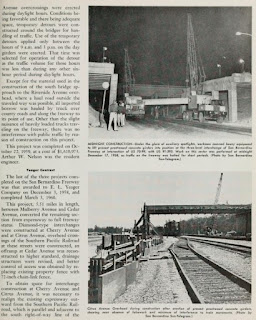
November/December 1954 California Highways & Public Works announced the Ramona Freeway was opened to traffic through the cities of Pomona, Claremont, Upland and Ontario on November 16th, 1954, over a span of 13.5 miles. The new segment of the Ramona Freeway included the split between US 99/US 70 and US 60 in Pomona.


The
January/February 1955 California Highways & Public Works announced the San Bernardino Freeway (former Ramona Freeway) was fully complete from the Santa Ana Freeway east to CA 19/LRN 168 at Rosemead Boulevard. US 99/US 70/LRN 26 was shifted to the San Bernardino Freeway originating at San Dimas Avenue in Pomona east through Claremont to the San Bernardino County Line upon its opening on December 3rd, 1954.
On June 29th, 1956, the Federal Highway Aid Act of 1956 was signed into law on the Federal Level. The Federal Highway Aid Act of 1956 was the genesis point of the Interstate Highway System which would in the coming decade sew the demise via of US 60 and US 70 in California. Much of US 60 and US 70 in the coming decade would become components of Interstate 10 (I-10).
US 70 was approved to be truncated from Los Angeles to US 95 in Blythe by the AASHO on August 26th, 1963. The truncation of US 70 removed it entirely from the San Bernardino Freeway leaving I-10 as the only highway fully aligned over it.


The changes to the US Route System around Los Angeles illustrated above can be seen in effect on the
1964 Division of Highways Map. US 99 is seen terminating via I-5 and the Golden State Freeway at I-10/US 60 at the San Bernardino Freeway. What had been US 99/US 70/US 60 on the San Bernardino Freeway between the Santa Ana Freeway and Golden State Freeway is shown assigned as the original I-110.
The AASHO Executive Committee approved US 60 to be truncated from downtown Los Angeles to US 95 in Blythe on October 2nd, 1965. The truncation of US 60 to Blythe left only I-10 signed on the San Bernardino Freeway between Los Angeles and Pomona. The approval of US 60 to Blythe does contain a note that the Division of Highways intended to keep the highway signed on segment of I-10 which had not been completed.
The
1967 Division of Highways Map is the first edition to display US 60 removed from the Los Angeles-Pomona corridor completely in favor of I-10.


Comments