Prior to the Statehood the first signed highways within Hawaii Territory came into existence during World War II.
During World War II the territory of Hawaii saw an influx of military activity following the attack on Pearl Harbor on December 7th, 1941. Numerous Military Routes and early Hawaii Routes were signed through the Hawaiian Territory to aid military personnel in navigating the islands. Military Highways were assigned US Route style shields whereas lesser highways were assigned an early variation of what is now the Hawaii Route Spade. The original Hawaii Route Spade may have been an homage to the earliest versions of the California Highway Spade. A 1946 Army Map of the Island of Oahu shows the entirety of the World War II era highway system. A full version of the 1946 Army Map of Oahu can be seen hosted on hawaiihighways.com here.
The Military Routes and Hawaii Routes on Oahu during World War II followed a grid convention. The two-digit Military Routes were spurs of Military Route 1 whereas the Hawaii Routes were spurs of Military Route 1 or Miliary Route 2. The Hawaii Routes appears to be largely sequentially numbered ascending in a clockwise direction around Oahu.
Circa 1955 following the conclusion of World War II the United States Bureau of Public Roads renumbered the Hawaii Route System. The 1955 Hawaii Route Renumbering saw most of the conventions utilized by the current Hawaii State Route System established. Primary Hawaii Routes were given two-digit numbers whereas Secondary Hawaii Routes were given three-digit numbers. The Hawaii Routes were assigned in sequence for what Island/County they were located on coupled with what Federal Aid Program number they were tied to. In the case of Oahu the Island was assigned numbers in the range of 60-99.This page is part of the Gribblenation Hawaii Roads series. A compellation of all Hawaii-related media from both Gribblenation and RoadwayWiz can be found by clicking
here.
Military Route 1
1946 Army Map of Oahu displays Military Route 1 acting as an eastern loop of Oahu Military Route 1 is shown to not have a true origination point but acted as the main hub for much of the World War II highway system on Oahu. From downtown Honolulu Military Route 1 is shown following Dillingham Boulevard (what would become Hawaii Route 90) to Kamehameha Highway. Military Route 1 followed Kamehameha Highway from the Honolulu to Wahiawa (now Hawaii Route 99). Military Route 1 followed Kamehameha Highway through Wahiawa (now Hawaii Route 80) to Kaukonahua Road (now Honolulu County Routes 801 and 803). Military Rotue 1 followed Kaukonahua Road too Thompson's Corner where it turned north. From Thompson's Corner Military Route 1 followed Kaukonahua Road (now Hawaii Route 930) to Kamehameha Highway in Haleiwa. Military Route 1 followed Kamehameha Highway from Haleiwa across the northern tip of Oahu (now Hawaii Route 83 and Honolulu County Route 836 in the vicinity of Kaneohe) to the vicinity of Maunawili. From Mauanwili Military Route 1 followed Auloa Road and Ulupuni Street to Kalanianaole Highway (now Hawaii Route 72). Military Route 1 followed Kalanianole Highway around the eastern tip of Oahu which looped it back into the city of Honolulu. Through Honolulu Military Route 1 looped back to Dillingham Boulevard via Waialae Avenue, Kapiolani Boulevard and King Street.


Military Route 2
Military Route 2 is shown on the 1946 Army Day Map of Oahu originating from Military Route 1 via Farrington Highway at Ewa Junction. Military Route 2 is shown following Farrington Highway the western shores of Oahu where it terminated near Kaena Point at Makua Beach. The corridor of Military Route 2 became Hawaii Route 90 but is presently occupied by Hawaii Route 99, Hawaii Route 7101, Hawaii Route 7110 and Hawaii Route 93.
Military Route 2/Farrington Highway can be seen facing westward from Hawaii Route 211/Ewa Beach Road (now Old Fort Weaver Road) in the two photos below. These photos would be where the present terminus of Hawaii Route 7110 on Farrington Highway is located in modern times. Military Route 3
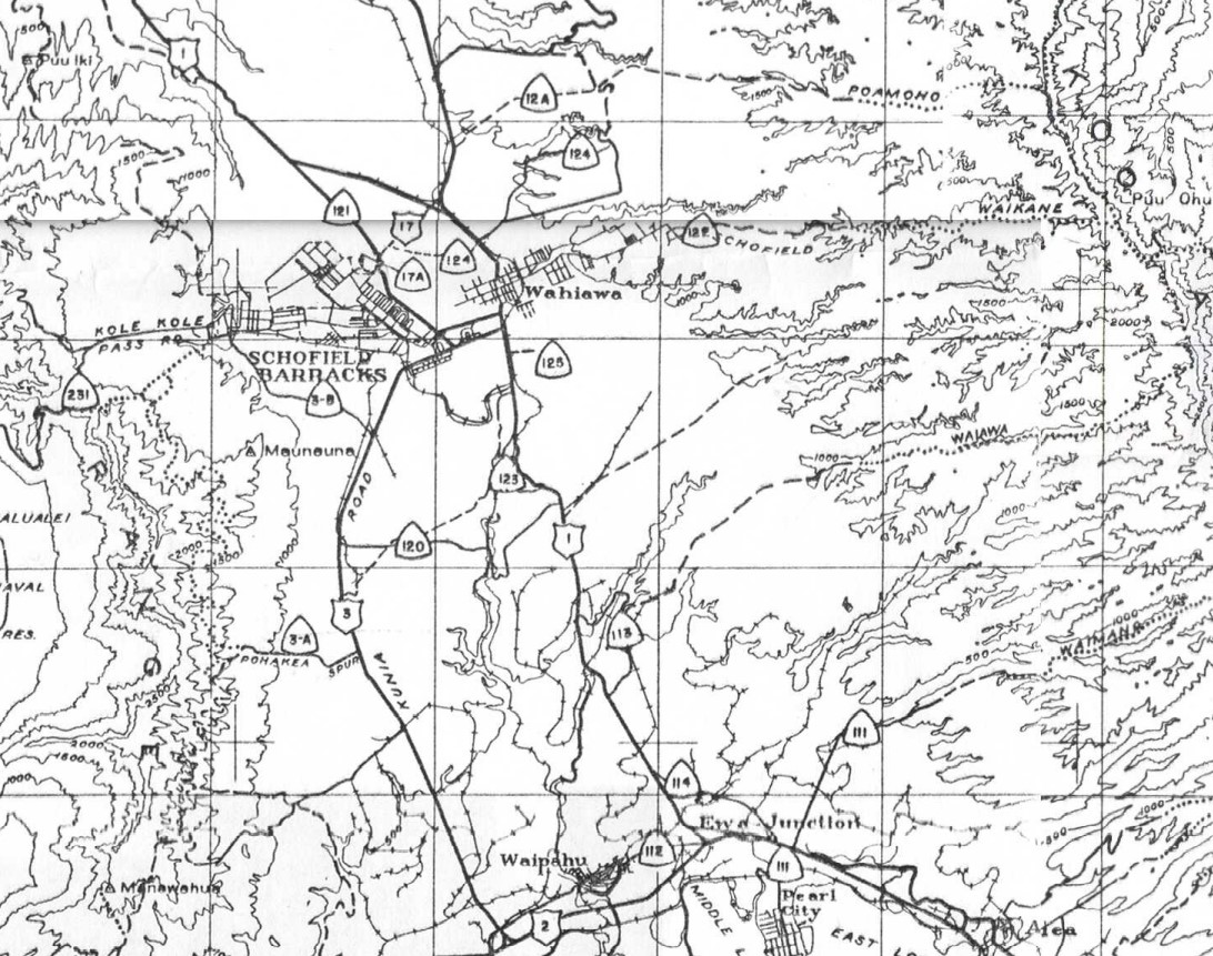
Military Route 3 is shown on the 1946 Army Day Map of Oahu following Kunia Road from Military Route 2/Farrington Highway north to Military Route 17/Wilikina Drive in Wahiawa. The corridor of Military Route 3 is presently occupied by Hawaii Route 750.
Hawaii Route 3AHawaii Route 3A is shown on the 1946 Army Day Map of Oahu branching from Military Route 3/Kunia Road west towards Pohakea Pass via the Pohakea Spur. What was Hawaii Route 3A is presently occupied by Palawai Road.
Hawaii Route 3BHawaii Route 3B is shown on the 1946 Army Day Map of Oahu branching from Military Route 3/Kunia Road west through Schofield Barracks towards Kolekole Road. What was Hawaii Route 3B is presently occupied by Range Road in the Schofield Barracks.
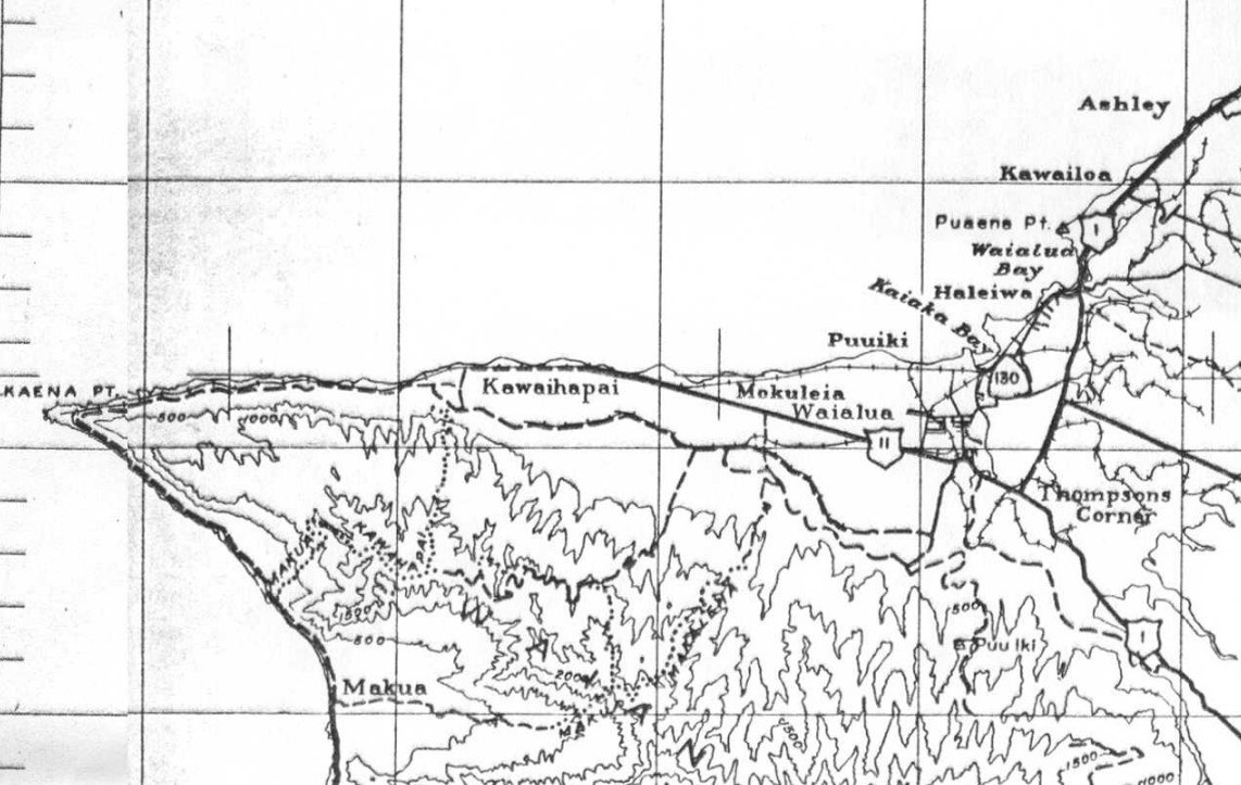
Military Route 11
Military Route 11 is shown on the 1946 Army Day Map of Oahu following Farrington Highway from Thompson's Corner west towards Kawaihapai near Kaena Point. The corridor of Military Route 11 is now occupied by Hawaii Route 930.
Military Route 12Military Route 12 is shown on the 1946 Army Day Map of Oahu following Kamehameha Highway from Military Route 1 near Wahiawa northward looping back to Military Route 1 near Haleiwa. The corridor of Military Route 12 is presently occupied by Hawaii Route 99.
Hawaii Route 12A
Hawaii Route 12A is shown branching from Military Route 12/Kamehameha Highway north of Wahiawa. Hawaii Route 12A is shown following a dirt road east from Military Route 12 to the Poamoho Trail. There appears to be no modern analog for Hawaii Route 12A on the modern Helemano Military Reservation.
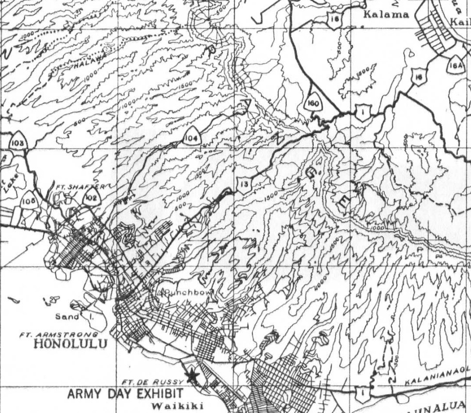
Military Route 13Military Route 13 is shown originating on the 1946 Army Day Map of Oahu in downtown Honolulu at Military Route 1/King Street. Military Route 13 is shown following Nuuanu Avenue, the Old Pali Highway and Kamehameha Highway over the Koolau Range to Military Route 1 near Maunawili. The corridor of Military Route 13 was reassigned as Hawaii Route 61 but has been since largely modernized.
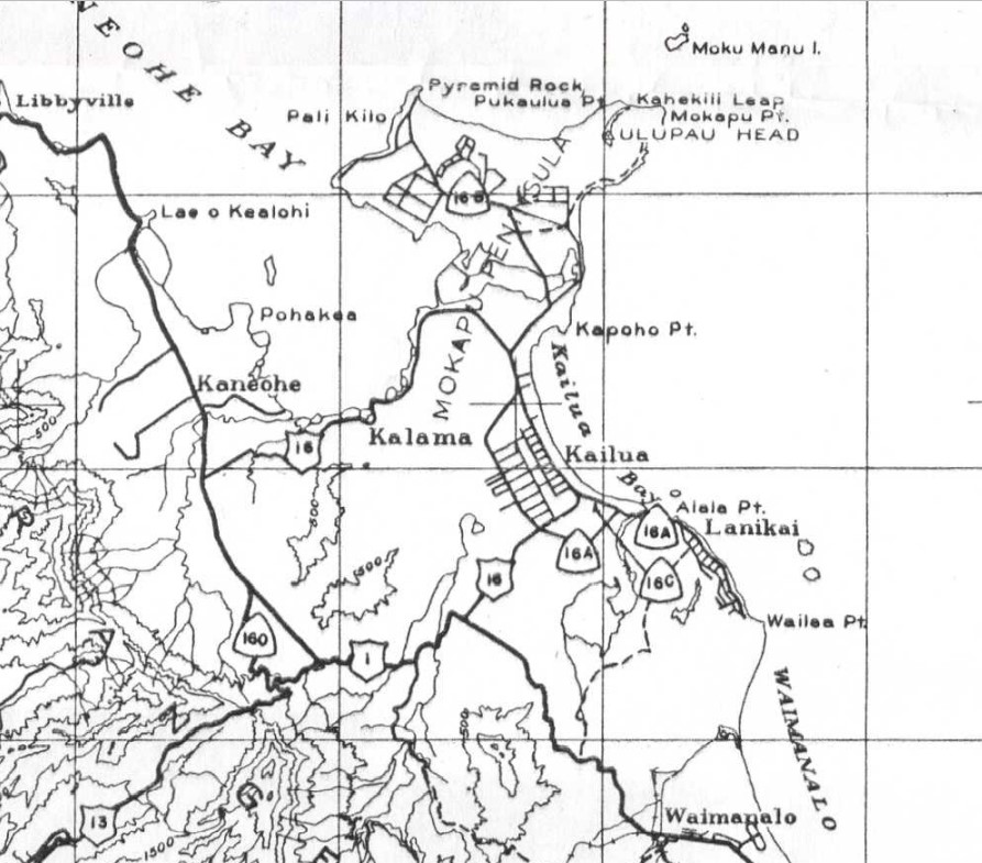
Below a Military Route 13 shield can be seen. Military Route 16Military Route 16 is shown on the 1946 Army Day Map of Oahu originating at Military Route 1 in Kaneohe. Military Route 16 is shown following Kaneohe Bay Drive (what became Hawaii Route 63 and is now Hawaii Route 65/Hawaii Route 630) to Kailua. Within Kailua Military Route 16 is shown following Kalaheo Avenue, Kuulei Road and Ulupuni Street to Military Route 1.
Hawaii Route 16AHawaii Route 16A is shown on the 1946 Army Day Map of Oahu originating from Military Route 16 at Kalaheo Drive in Kailua. Hawaii Route 16A is shown following Kainui Drive, Oneawa Street, Kailua Road, Lihiwai Road, Kawailoa Road, Alala Road and Mokulua Drive to Lanikai. Hawaii Route 16A appears to have become Hawaii Route 618 for a time after the creation of the 1955 Hawaii Route System.
Hawaii Route 16B
Hawaii Route 16B is shown on the 1946 Army Day Map of Oahu originating from Military Route 16/Kaneohe Bay Drive. Hawaii Route 16B is shown following Mokapu Road north onto the Mokapu Peninsula through the present site of Marine Corps Base Hawaii. For a time Mokapu Road was part of post-1955 Hawaii Route 630.
Hawaii Route 16C
Hawaii Route 16C is shown on the 1946 Army Day Map of Oahu originating from Hawaii Route 16A in Lanikai south via a dirt road to Military Route 1. Most of what was Hawaii Route 16C appears to have been obliterated by modern construction, but a small segment appears to still exist as Kamahele Street south from Lanikai over Kalwa Ridge.
Military Route 17
Military Route 17 is shown on the 1946 Army Day Map of Oahu following Wilikina Drive and Kamananui Road to/from Military Route 1/Kamehameha Highway. The corridor of what was Military Route 17 is presently part of Hawaii Route 99.
Hawaii Route 17A
Hawaii Route 17A is shown on the 1946 Army Day Map of Oahu jutting east from Military Route 17/Wilikina Drive near Wahiawa. What was Hawaii Route 17A appears to no longer exist or correspond to a current road.
Hawaii Route 101
Hawaii Route 101 is shown on the 1946 Army Day Map of Oahu acting as a loop of Military Route 1 in eastern Honolulu. Hawaii Route 101 is shown branching from Military Route 1/Kapiolani Boulevard southeast through Waikiki via Kalakaua Avenue towards Diamond Head Crater. Hawaii Route 101 is shown following Diamond Head Road, Kahala Avenue and Kealaolu Avenue back to Military Route 1/Kalanianaole Highway. Despite Kalakaua Avenue becoming the main tourist drive in Waikiki it was never part of the 1955 Hawaii Route System.
Hawaii Route 102
Hawaii Route 102 is shown on the 1946 Army Day Map of Oahu connecting Hawaii Route 103/King Street via Middle Street and School Street to Hawaii Route 104/Kalihi Street in Honolulu. What was Hawaii Route 102 never became part of the 1955 Hawaii Route System.
Hawaii Route 103
Hawaii Route 103 is shown on the 1946 Army Day Map of Oahu originating at Miliary Route 1/Dillingham Boulevard in Honolulu. Hawaii Route 103 is shown following King Street and Moanalua Road west to Military Route 1/Kamehameha Highway at Ewa Junction. Hawaii Route 103 would become part of Hawaii Route 72 in the 1955 Hawaii Route System and later the second Hawaii Route 78. The second Hawaii Route 78 would gradually be upgraded into a freeway and would become Interstate H-201.
Hawaii Route 104
Hawaii Route 104 is shown on the 1946 Army Day Map of Oahu originating at Hawaii Route 103/King Street in Honolulu. Hawaii Route 104 is shown following Kahili Street into the Koolau Range. Hawaii Route 104 would become part of Hawaii Route 63 in the 1955 Hawaii Route System but largely has been since bypassed upon the construction of the Likelike Highway.
Hawaii Route 105
Hawaii Route 105 is shown on the 1946 Army Day Map of Oahu following Puuloa Road between Military Route 1/Kamehameha Highway north to Hawaii Route 103/Moanalua Road. Hawaii Route 105 became Hawaii Route 66 in the 1955 Hawaii Route System and now is Hawaii Route 7310.
Hawaii Route 110
Hawaii Route 110 is shown on the 1946 Army Day Map of Oahu branching from Military Route 1/Kamehameha Highway west into Hickam Army Airfield. Hawaii Route 110 would become part of Hawaii Route 92/Nimitz Highway in the 1955 Hawaii Route System and was partially aligned on what was is now South Avenue in Joint Base Pearl Harbor-Hickam.
Hawaii Route 111
Hawaii Route 111 is shown on the 1946 Army Day Map of Oahu beginning in Pearl City via Lehua Avenue. Hawaii Route 111 is shown following Lehua Avenue and Waimano Home Road north to a terminus in the Koolau Range. For a time, what was Hawaii Route 111 became Hawaii Route 73 in the 1955 Hawaii Route System.
Hawaii Route 112
Hawaii Route 112 is shown on the 1946 Army Day Map of Oahu beginning at Military Route 1/Kamehameha Highway at Ewa Junction. Hawaii Route 112 is shown following Waipahu Street west through Waipahu to Military Route 2/Farrington Highway. Hawaii Route 112 never became part of the 1955 Hawaii Route System.
Hawaii Route 113
Hawaii Route 113 is shown on the 1946 Army Day Map of Oahu beginning at Military Route 1/Kamehameha Highway and heading east into the Koolau Range to the Waiawa Trail. It isn't fully clear, but it appears what is Hawaii Route 113 may be now partially Waiawa Prison Road.
Hawaii Route 114
Hawaii Route 114 is shown on the 1946 Army Day Map of Oahu as a cutoff of Military Route 1/Kamehameha Highway in Ewa Junction. What was Hawaii Route 114 appears to have been obliterated during the construction of the Interstate H-1/Interstate H-2 interchange along with much of what was Ewa Junction.
Hawaii Route 120
Hawaii Route 120 is shown on the 1946 Army Day Map of Oahu as a connecting Military Route 3/Kunia Road east to Military Route 1/Kamehameha Highway. No modern roads align to what was Hawaii Route 120.
Hawaii Route 121
Hawaii Route 121 is shown on the 1946 Army Day Map of Oahu following Wilikina Drive from Military Route 17 northwest to Military Route 1 near Wahiawa. Hawaii Route 121 would become part of Hawaii Route 99 when the 1955 Hawaii Route System was created and is presently part of Honolulu County Route 803.
Hawaii Route 122
Hawaii Route 122 is shown on the 1946 Army Day Map of Oahu following California Avenue east from Military Route 1/Kamehameha Highway in Wahiawa easts to the Schofield-Waikane Trail. Hawaii Route 122 was never part of the 1955 Hawaii Route System.
Hawaii Route 123
Hawaii Route 123 is shown on the 1946 Army Day Map of Oahu connecting Hawaii Route 120 to Military Route 1/Kamehameha Highway. Just as Hawaii Route 120 the alignment of Hawaii Route 123 has no modern analog.
Hawaii Route 124
Hawaii Route 124 is shown on the 1946 Army Day Map of Oahu originating at Military Route 17/Kamananui Road east to Military Route 1/Kamehameha Highway. From Military Route 1 the alignment of Hawaii Route 124 is shown following Whitmore Avenue and Saipan Drive into the Koolau Range. The segment of Hawaii Route 124 between Military Route 17 and Military Route 1 no longer exists. What was Military Route 124 on Whitmore Drive partially became Hawaii Route 7012 after the 1955 Hawaii Route System was created. Saipan Drive is now an inaccessible road in the Wahiawa Military Reservation.
Hawaii Route 125
Hawaii Route 125 is shown on the 1946 Army Day Map of Oahu branching east from Military Route 1/Kamehameha near Wahiawa via a short dirt road. The road that comprised Hawaii Route 125 appears to no longer exist.
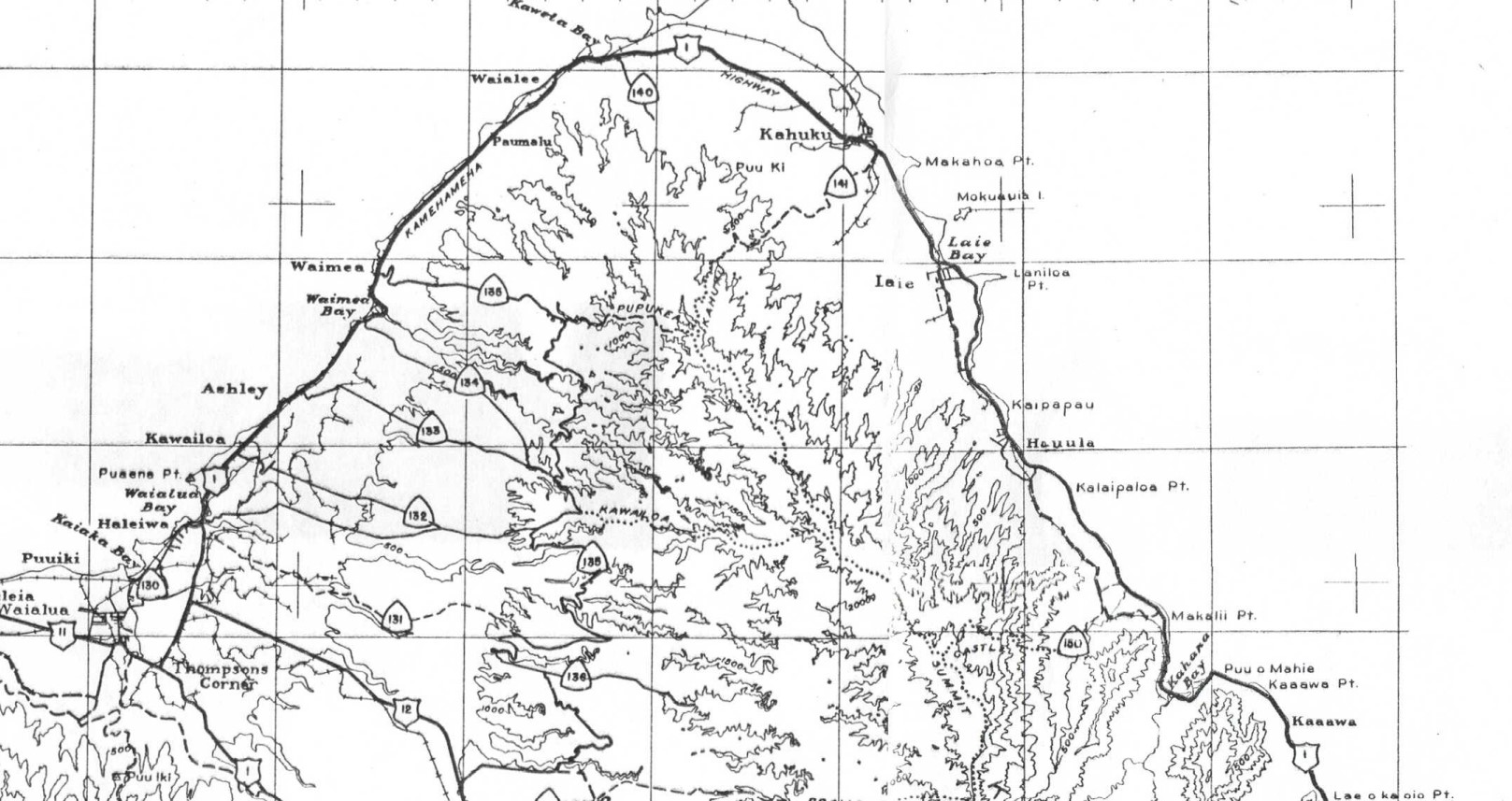
Hawaii Route 130
Hawaii Route 130 is shown on the 1946 Army Day Map of Oahu as following Haleiwa Road south from Military Route 1/Kamehameha Highway to the vicinity of Kaiaka Bay. Hawaii Route 130 would for a time become part of Hawaii Route 821 in the 1955 Highway Route System.
Hawaii Route 131
Hawaii Route 131 is shown on the 1946 Army Day Map of Oahu branching east from Military Route 1/Kamehameha Highway in Haleiwa to Hawaii Route 135 in the Koolau Range. Hawaii Route 131 appears to align directly with modern Opaeula Road and was never part of the 1955 Hawaii Route System.
Hawaii Route 132
Hawaii Route 132 is shown on the 1946 Army Day Map of Oahu branching east from Military Route 1/Kamehameha Highway in Kawailoa to Hawaii Route 135 in the Koolau Range. Hawaii Route 132 appears to align directly with modern Kawailoa Drive and was never part of the 1955 Hawaii Route System.

Hawaii Route 133
Hawaii Route 133 is shown on the 1946 Army Day Map of Oahu branching east from Military Route 1/Kamehameha Highway in Ashley to Hawaii Route 135 in the Koolau Range. Hawaii Route 133 appears to align directly with modern Ashley Road and was never part of the 1955 Hawaii Route System.
Hawaii Route 134
Hawaii Route 134 is shown on the 1946 Army Day Map of Oahu branching east from Military Route 1/Kamehameha Highway at Waimea Bay to Hawaii Route 135 in the Koolau Range. Hawaii Route 134 appears to align directly with modern Waimea Valley Road and Waimea Valley Trail. What was Hawaii Route 134 was never part of the 1955 Hawaii Route System.
Hawaii Route 135
Hawaii Route 135 is shown on the 1946 Army Day Map of Oahu branching east from Military Route 1/Kamehameha Highway in Waimea towards the Koolau Range. Hawaii Route 135 is shown following Pupukea Road and Paalaa Uka Pupukea Road to Hawaii Route 136. The segment of Hawaii Route 135 on Pupukea Road for a time became Hawaii Route 835 in the 1955 Hawaii Route System.
Hawaii Route 136
Hawaii Route 136 is shown on the 1946 Army Day Map of Oahu branching east from Military Route 12/Kamehameha Highway into the Koolau Range. Hawaii Route 136 is shown following Paalaa Uka Pupukea Road to Hawaii Route 135 and what is now Twin Bridge Road east to a dead end in the Koolau Range. What was Hawaii Route 136 was never part of the 1955 Hawaii Route System.
Hawaii Route 140
Hawaii Route 140 is shown on the 1946 Army Day Map of Oahu branching south from Military Route 1/Kamehameha Highway into the Koolau Range via what is now Kawela Camp Road south of Kawela. What was Hawaii Route 140 never was part of the 1955 Hawaii Route System.
Hawaii Route 141
Hawaii Route 141 is shown on the 1946 Army Day Map of Oahu branching south from Military Route 1/Kamehameha Highway into the Koolau Range near Kahuku. The road which comprised Hawaii Route 141 appears to no longer exist and has been built over by new development around Kahuku.
Hawaii Route 150
Hawaii Route 150 is shown on the 1946 Army Day Map of Oahu branching west from Military Route 1/Kamehameha Highway from Makalii Point into the Koolau Range. There is no apparent modern road which would align with what was Hawaii Route 150, but it appears to have connected with a trail to Castle Summit.
Hawaii Route 151
Hawaii Route 151 is shown on the 1946 Army Day Map of Oahu branching west from Military Route 1/Kamehameha Highway from Waikane into the Koolau Range. Hawaii Route 151 appears to have followed North Waiahole Valley Road and was never part of the 1955 Hawaii Route System.
Hawaii Route 160
Hawaii Route 160 is shown on the 1946 Army Day Map of Oahu branching south from Military Route 1/Kamehameha Highway via the Old Pali Highway to Military Route 13 at Nuuanu Pail. Hawaii Route 160 possibly was for a short time part of Hawaii Route 61 in the 1955 Hawaii Route System before the Old Pail Highway was being replaced.
Hawaii Route 170
Hawaii Route 170 is shown on the 1946 Army Day Map of Oahu branching south from Military Route 1/Kalanianaole Highway towards Hanauma Bay and Koko Head via what is now Hanauma Bay Road. What was Hawaii Route 170 was never part of the 1955 Hawaii Route System.
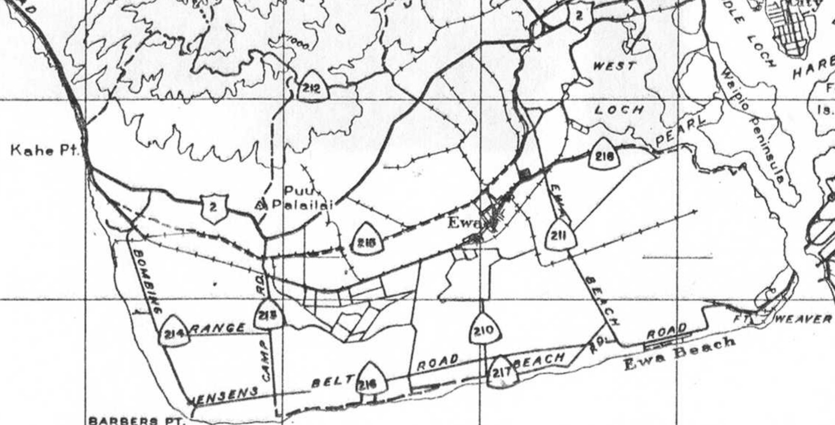
Hawaii Route 210
Hawaii Route 210 is shown on the 1946 Army Day Map of Oahu appears as an unknown road within Naval Air Station Barbers Point. What was Hawaii Route 210 likely no longer exists having been razed by modern development south of Ewa.
Hawaii Route 211
Hawaii Route 211 is shown on the 1946 Army Day Map of Oahu as branching south from Military Route 2/Farrington Highway via Ewa Beach Road to Fort Weaver. Hawaii Route 211 would become part of Hawaii Route 76 in the 1955 Hawaii Route System on what came be known as Old Fort Weaver Road and Fort Weaver Road.

Military Route 2/Farrington Highway can be seen facing westward from Hawaii Route 211/Ewa Beach Road (now Old Fort Weaver Road) in the two photos below. These photos would be where the present terminus of Hawaii Route 7110 on Farrington Highway is located in modern times. Hawaii Route 212
Hawaii Route 212 is shown on the 1946 Army Day of Oahu branching from Military Route 2/Farrington Highway west through the Waianae Range towards Kane Point. Hawaii Route 212 appears to have been intended to access a peak known as Monawahua and doesn't have a modern analog.
Hawaii Route 213Hawaii Route 213 is shown on the 1946 Army Day Map of Oahu branching south from Military Route 2/Farrington Highway via what was known as Camp Road in Naval Air Station Barbers Point. Hawaii Route 213 appears to not have a modern analog road.
Hawaii Route 214Hawaii Route 214 is shown on the 1946 Army Day Map of Oahu as a bombing range road of Naval Air Station Barbers Point. Hawaii Route 214 appears to not have a modern analog road.
Hawaii Route 215
Hawaii Route 215 is shown on the 1946 Army Day Map of Oahu as an east/west dirt road through Naval Air Station Barbers Point. Hawaii Route 215 appears to originate at Hawaii Route 211 and track westward to Military Route 2/Farrington Highway. Hawaii Route 215 does not appear to have a modern analog road.
Hawaii Route 216
Hawaii Route 216 is shown on the 1946 Army Day Map of Oahu following Hansens Belt Road in Naval Air Station Barbers Point. Hawaii Route 216 does not have a modern analog road.
Hawaii Route 217
Hawaii Route 217 is shown on the 1946 Army Day Map of Oahu branching from Hawaii Route 211 via Beach Road in Naval Air Station Barbers Point. Hawaii Route 217 does not appear to have a modern analog road.
Hawaii Route 218
Hawaii Route 218 is shown on the 1946 Army Day Map of Oahu branching east from Hawaii Route 211 to the West Loch of Pearl Harbor. What was Hawaii Route 218 appears to now be Arizona Road of the U.S. Naval Magazine West Loch Branch.
Hawaii Route 230
Hawaii Route 230 is shown on the 1946 Army Day Map of Oahu branching north from Hawaii Route 2/Farrington Highway through Lualualei Naval Reservation to Hawaii Route 231/Kolekole Road. Hawaii Route 230 would become part of the first Hawaii Route 78 on Lualualei Naval Road for a time when the 1955 Hawaii Route System was created.
Hawaii Route 231
Hawaii Route 231 is shown on the 1946 Army Day Map of Oahu branching east from Hawaii Route 2/Farrington Highway towards Kolekole Pass in the Waianae Range and the Schofield Barracks to Hawaii Route 3B. Hawaii Route 231 is shown following Waianae Valley Road, Haleahi Road, Waianae, Kolekole Road and Trimble Road. Parts of Hawaii Route 231 became Hawaii Route 782 and the first Hawaii Route 78 in the 1955 Hawaii Route System. Kolekole Road over Kolekole Pass in the Waianae Range was never part of the 1955 Hawaii Route System.
The road over Kolekole Pass was constructed as part of the greater Lualualei Naval Road by the U.S. Army 3rd Corps of Engineers during 1937. Kolekole Pass lies at an elevation of 1,724 feet above sea level and despite not being open to the public is the only road over the Waianae Range. More regarding Kolekole Pass appears in a
2010 Hawaii Legislative Reference Bureau document.


Comments