
Former Hawaii Route 90

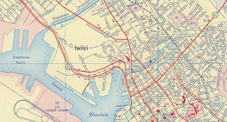
Former Hawaii Route 90 is a decommissioned Hawaii State Highway which was once one of the largest signed routes on the Island of O'ahu.  Hawaii Route 90 originated in downtown Honolulu following Dillingham Boulevard west from what was Hawaii Route 72 at King Street.  West of Honolulu the alignment of Hawaii Route 90 was aligned on the Kamehameha Highway towards Ewa Junction near Pearl City and the Farrington Highway to Ka'ena Point.  Below Hawaii Route 90 can be seen at its greatest extent on the 1959 Gousha Highway Map of Hawaii.  


This page is part of the Gribblenation Hawaii Roads series.  A compellation of all Hawaii-related media from both Gribblenation and RoadwayWiz can be found by clicking here


Part 1; the history of Hawaii Route 90

Prior to the Statehood the first signed highways within Hawaii Territory came into existence during World War II.   During World War II the territory of Hawaii saw an influx of military activity following the attack on Pearl Harbor on December 7th, 1941.  Numerous Military Routes and early Hawaii Routes were signed through the Hawaiian Territory to aid military personnel in navigating the islands.  Military Highways were assigned US Route style shields whereas lesser highways were assigned an early variation of what is now the Hawaii Route Spade.  

A 1946 Army Map of the Island of O'ahu shows the future corridor of Hawaii Route 90 as part of Military Route 1 from Honolulu west to Ewa Junction and Military Route 2 to Makua.  A full version of the 1946 Army Map of O'ahu can be seen on hawaiihighways.com here

Below Hawaii Route 211/Ewa Beach Road can be seen branching from Military Route 2/Farrington Highway.

Circa 1955 following the conclusion of World War II the United States Bureau of Public Roads renumbered the Hawaii Route System.  The 1955 Hawaii Route Renumbering saw most of the conventions utilized by the current Hawaii State Route System established.  Primary Hawaii Routes were given two-digit numbers whereas Secondary Hawaii Routes were given three-digit numbers.  The Hawaii Routes were assigned in sequence for what Island/County they were located on coupled with what Federal Aid Program number they were tied to.  In the case of O'ahu the Island was assigned numbers in the range of 60-99.  Dillingham Boulevard and Kamehameha Highway from downtown Honolulu to Ewa Junction along with Farrington Highway to Ka'ena Point were assigned as Hawaii Route 90.  

As noted in the intro the full extent of Hawaii Route 90 can be seen on the 1959 Gousha Highway Map of Hawaii.  Hawaii Route 90 originated in downtown Honolulu following Dillingham Boulevard west from what was Hawaii Route 72 at King Street.  West of Honolulu the alignment of Hawaii Route 90 was aligned on the Kamehameha Highway towards Pearl City and the Farrington Highway to Ka'ena Point.  


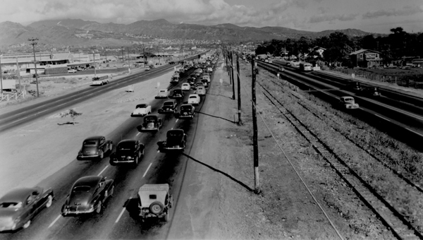
Through Naval Air Station Pearl Harbor Hawaii Route 90/Kamehameha Highway and Hawaii Route 92/Nimitz Highway notably were aligned alongside each other.  Below Nimitz Highway (on the left as the two-lane highway) and Kamehameha Highway can be seen running alongside each other west of downtown Honolulu in a Hawaii Department of Transportation photo from 1951 (courtesy hawaiihighways.com).

On August 21st, 1959, Hawaii became the 50th State which saw its profile rise significantly.  The Interstate System in Hawaii was authorized as part of the 1960 Statehood Act.  The 1960 Statehood Act authorized Interstates H-1, H-2 and H-3 on the Island of O'ahu.  Hawaii Route 92 and Hawaii Route 90 from the outskirts of Hickam Airforce Base east to downtown Honolulu was selected to become part of the Queen Liliuokalani Freeway segment of Interstate H-1.  Hawaii Route 90 from Hickam Airforce Base west towards Barbers Point was also selected to become part of the Queen Liliuokalani Freeway corridor of Interstate H-1.  

Much of the corridor of Interstate H-1 east of downtown Honolulu was inherited from Hawaii Route 72 and the existing Mauka Lateral.   Hawaiihighways.com details the construction history of Interstate H-1 on their O'ahu page.  The first segment of the Lunalilo Freeway to be constructed as Interstate H-1 between Exit 25B east to 26A was completed by 1965.  This segment can be seen under construction in the 1965 Hawaii Department of Transportation photo below.  


Interstate H-1 on the Queen Liliuokalani Freeway from Exit 5 (Hawaii Route 76/Hawaii Route 750) to its western terminus opened during 1967.  The remainder of the Lunalilo Freeway segment of Interstate H-1 in Honolulu was completed by July 1969.  The Queen Liliuokalani segment of I-H1 was completed east to Hawaii Route 78 (future Interstate H-201) by 1971.  The Queen Liliuokalani segment of Interstate H-1 was gradually extended east of Hawaii Route 78 to the Lunalilo Freeway segment of Interstate H-1 culminating in the completion of the Intestate during May of 1986.  

Following the completion of various segments of Interstate H-1 the corridor of Hawaii Route 90 was disposed of in numerous ways.  Hawaii Route 90 can be seen on the 1969 USGS Map of Honolulu truncated to small routing following Dillingham Boulevard and Liliha Street east from Interstate H-1 to Hawaii Route 98 at Vineyard Boulevard.  


Hawaii Route 90 on Dillingham Boulevard and Liliha Street was eventually deleted from the Hawaii State Route System.  The remaining Hawaii Route 90 shield can be found on Kalihi Street (Hawaii Route 63) southbound approaching Dillingham Boulevard.  The below photo was taken by Dan Murphy of Gribblenation and the Roadwaywiz Youtube Channel during 2019.  


Interstate H-1 from the outskirts of downtown Honolulu west to Hickam Air Force Base was ultimately constructed over Hawaii Route 92/Nimitz Highway and Hawaii Route 90/Kamehameha Highway.  Hawaii Route 92/Nimitz Highway would ultimately be retained underneath Interstate H-1 whereas Hawaii Route 90/Kamehameha Highway was deleted.   

Hawaii Route 90/Kamehameha Highway from Hawaii Route 92/Nimitz Highway west to Ewa Junction near Pearl City was assigned as an extension of Hawaii Route 99 following the completion of Interstate H-1.  Below Hawaii Route 99 can be seen beginning its northbound course from Hawaii Route 92/Nimitz Highway on the 1983 USGS Map of Hawaii.  


Following the completion of Interstate H-1 what was Hawaii Route 90 on Farrington Highway west from Ewa Junction to Hawaii Route 76 was reassigned as Hawaii Route 7101.  Below Hawaii Route 7101 can be seen branching onto Farrington Highway from Hawaii Route 99/Kamehameha Highway northbound at Ewa Junction.  


West of Hawaii Route 76 to Old Fort Weaver Road what was Hawaii Route 90 on Farrington Highway was retained as part of Hawaii Route 7110.  Below the transition on westbound Farrington Highway from Hawaii Route 7101 to Hawaii Route 7110 can be seen.  


Following the completion of Interstate H-1 former Hawaii Route 90/Farrington Highway west from Old Fort Weaver Road to Makakilo Drive was relinquished from the State Highway System.  The Farrington Highway from Makakilo Drive was bisected by the construction of Interstate H-1.  What was Hawaii Route 90 the Farrington Highway from Interstate H-1 Exit 1E west to the entrance of Ka'ena Point State Park was reassigned as Hawaii Route 93.  What was Hawaii Route 90 on Farrington Highway from the boundary of Ka'ena Point State Park has been abandoned and repurposed into as part of the Ka'ena Point Trail

Comments

Popular posts from this blog

The Tale of Tollhouse Road, western California State Route 168 and failed Piute Pass Highway

Western California State Route 168 is entirely located in Fresno County and is linked historically to the Tollhouse Road corridor.   Tollhouse Road is one of the oldest highways in the Sierra Nevada range of Fresno County. The corridor presently begins in at Clovis Avenue in downtown Clovis and extends northeast to Huntington Lake. In 1866 the Woods Brothers established mining claims on Pine Ridge. In 1867 Fresno County would grant the brothers a toll franchise to construct a roadway to the desirable logging areas atop Pine Ridge and near Dinkey Creek. The Woods would establish a tollhouse at the start of their franchise road and lumber mill. The lumber mill attracted settlers which led to the establishment of the mountain town of Tollhouse. Fresno County would purchase the Tollhouse Road in 1878 and make it a public highway. The county would remove the tolls and incorporate the corridor into the existing county road network. Prior to the establishment of Clovis in 1...

Old Dunlap Road (former California State Route 180 in Yokuts Valley)

When California State Route 180 was commissioned in August 1934 the alignment in took in Sierra Nevada range was very different than from today.  The original highway alignment from Squaw Valley (now Yokuts Valley) to east Grant Grove (then part of General Grant National Park) originally followed what is now Ruth Hill Road, Dunlap Road, Pinehurst Road (modern California State Route 245), Dark Canyon Road (partially now Forest Road 14S45).  After funding fell through for the planned Kings Canyon Road the was corridor eventually picked up as a 30-mile-long cooperative project between the Division of Highways and Federal Government.  Much of current alignment of California State Route 180 bypassing Squaw Valley (now Yokuts Valley) and Dunlap was complete by 1941.  The post-1941 alignment of California State Route 180 in Squaw Valley was shifted onto what was once Dunlap Road in Squaw Valley.  This alignment itself was later bypassed by modern California State Route...

New River Gorge National Park & Preserve - Thurmond

New River Gorge National Park and Preserve is best known for whitewater rafting and other forms of adventure tourism.  Yet, found in the hollows and isolated valleys are quiet farms and former coal mining towns.  Well off the beaten path and isolated from much of its surroundings, Thurmond provides a unique view into Central West Virginia's industrial past. Thurmond began as a railroad town in the late 1800s.  Sparked by the arrival of the Chesapeake & Ohio Railroad and the local coal industry, Thurmond quickly grew into a sizeable transportation and coal center.  When it incorporated as a town in 1903, Thurmond was a full-fledged community - home to two banks, two hotels, and many other services and stores. A CSX freight train passes the old coaling tower in Thurmond.  It was here that many steam locomotives would refill and refuel. Thurmond was home to a C&O railyard which serviced the numerous steam engines passing through the narrow valley.  Thu...