
Hawaii Route 7012

Hawaii Route 7012 is a 1.9-mile State Highway located on the Island of O'ahu.  Hawaii Route 7012 begins at Hawaii Route 80/Kamehameha Highway and follows Whitmore Avenue east to the Wahiawa Naval Reservation.  Hawaii Route 7012 was once assigned as Hawaii Route 804 and still appears as such on some maps.  


This page is part of the Gribblenation Hawaii Roads series.  A compellation of all Hawaii-related media from both Gribblenation and RoadwayWiz can be found by clicking here


Part 1; the history of Hawaii Route 7012

Prior to the Statehood the first signed highways within Hawaii Territory came into existence during World War II.   During World War II the territory of Hawaii saw an influx of military activity following the attack on Pearl Harbor on December 7th, 1941.  Numerous Military Routes and early Hawaii Routes were signed through the Hawaiian Territory to aid military personnel in navigating the islands.  Military Highways were assigned US Route style shields whereas lesser highways were assigned an early variation of what is now the Hawaii Route Spade.  

A 1946 Army Map of the Island of O'ahu shows the future corridor of Hawaii Route 7012 is shown to partially be on the alignment of Hawaii Route 124.  Hawaii Route 124 is shown diverging from Whitmore Avenue onto what is now Saipan Drive.  A full version of the 1946 Army Map of O'ahu can be seen on hawaiihighways.com here


Circa 1955 following the conclusion of World War II the United States Bureau of Public Roads renumbered the Hawaii Route System.  The 1955 Hawaii Route Renumbering saw most of the conventions utilized by the current Hawaii State Route System established.  Primary Hawaii Routes were given two-digit numbers whereas Secondary Hawaii Routes were given three-digit numbers.  The Hawaii Routes were assigned in sequence for what Island/County they were located on coupled with what Federal Aid Program number they were tied to.  In the case of Whitmore Avenue it was not assigned one of the initial post-1955 Hawaii Route numbers.  Whitmore Avenue can be seen on the 1959 Gousha Highway Map of Hawaii branching east from Hawaii Route 80/Kamehameha Highway near Wahiawa. 


The post-1955 designation history of Whitmore Avenue isn't fully clear, but it can be seen as Hawaii Route 804 on the 1983 USGS Map of Wahiawa.  


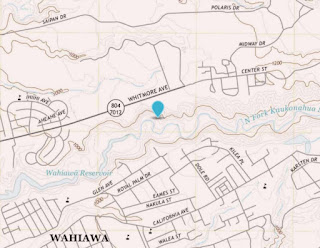
For unknown reasons Whitmore Avenue appears as both Hawaii Route 804 and Hawaii Route 7012 on the 2017 USGS Map of Wahiawa. 


Part 2; a drive on Hawaii Route 7012

North of the Karsten Thot Bridge Hawaii Route 80/Kamehameha Highway intersects Hawaii Route 7012 at Whitmore Avenue.  No route number is seen on Hawaii Route 80 northbound at Whitmore Avenue. 

At Whitmore Avenue southbound Hawaii Route 80 intersects Hawaii Route 7012.  From southbound Hawaii Route 80 southbound a single Hawaii Route 7012 shield can be found. 

During June 2019 Dan Murphy of the Roadwaywiz YouTube Channel (and Gribblenation) featured real-time drives on Hawaii Route 7012.  Below eastbound Hawaii Route 7012 on Whitmore Avenue can be observed. 

Below westbound Hawaii Route 7012 on Whitmore Avenue can be observed.

Comments

Popular posts from this blog

May 2023 Ontario Trip (Part 3 of 3)

  Over the years, I have made plenty of trips to Ontario, crisscrossing the southern, central and eastern parts of the province. Living in Upstate New York, it's pretty easy to visit our neighbor to the north, or is that our neighbor to the west? Ottawa is one of my favorite cities to visit anywhere in the world, plus I've discovered the charm of Kingston, the waterfalls of Hamilton (which is on the same Niagara Escarpment that brings us Niagara Falls), the sheer beauty of the Bruce Peninsula, and more. But I hadn't explored much of Cottage Country. So I decided to change that, and what better time to go than over Memorial Day weekend, when the daylight is long and I have an extra day to explore. On the third and final day of my trip, I started in Huntsville and made my way through Muskoka District and Haliburton County, passing by many lakes along the way. I stopped in towns such as Dorset, Haliburton and Bancroft before making a beeline down to Belleville and then over th...

Abandoned Fowler Avenue in Clovis, California

Originally Fowler Avenue in the city of Clovis had a brief discontinuation approaching Herndon Avenue.  Fowler Avenue traffic heading northbound was required to detour briefly onto westbound Herndon Avenue.  During 2001 this discontinuation was removed when Fowler Avenue was reconfigured to access the Sierra Freeway (California State Route 168) via an interchange.  This led to a segment of the original alignment of Fowler Avenue just south of Herndon Avenue to be abandoned.  Despite a shopping center opening over part of the original Fowler Avenue alignment in 2016 much of the abandoned roadway remains.   The history of the abandoned original alignment of Fowler Avenue in Clovis The original alignment of California State Route 168 departed downtown Clovis eastbound along Tollhouse Road.  This original alignment did not interact with Fowler Avenue at the Herndon Avenue intersection.  Fowler Avenue north of Tollhouse Road ran north to Herndon Avenue...

California State Route 78

California State Route 78 is a 194-mile east/west State Highway located in southern California.  California State Route 78 begins at Interstate 5 in Oceanside of San Diego County and terminates at Interstate 10 near Blythe of Riverside County.  California State Route 78 between Interstate 5 and Interstate 15 is aligned on the Ronald Packard Parkway over the corridor traditionally known as the Anza Freeway.  California State Route 78 east of Interstate 15 climbs over mountain grades into the Sonoran Desert where it become a largely rural highway.  The blog cover photo above is California State Route 78 on Vista Avenue between Oceanside and Vista as seen in the 1955 California Highways & Public Works.   Part 1; the history of California State Route 78 Disclaimer; the pre-State Highway history and Glamis Road elements of this blog are sourced from newspaper references attributed to AAroads forum user rschen7754 .  User rschen7754 was the primary Wikip...