
On the way home I decided that I was tired of traffic on the busy Bay Area freeways and decided something much more scenic to cross the Diablo Range; California State Route 130 over Mount Hamilton.
CA 130 is a 22 mile state highway running from US 101 in San Jose to the top of Mount Hamilton at the Lick Observatory. CA 130 was signed first in 1964 during the California Highway Renumbering and was previously unsigned Legislative Route 115 which was adopted back in 1933. CAhighways.org has a reference to LRN 115/CA 130 and maps from 1963/1964 show the difference in the designations.
1963 State Highway Map
1964 State Highway Map
CAhighways.org on CA 130
CA 130 eastbound starts at US 101 along Alum Rock Avenue. There is some CA 130 shields on guide signs along US 101.


Unfortunately the City of San Jose seems to think that CA 130 doesn't need to be signed along Alum Rock Avenue. Back in 2011 the Alum Rock portion of CA 130 was turned over to the City of San Jose. Despite legislative language instructing that CA 130 shields shall remain for navigational purposes the city has yet to put any up. I'm not certain if CA 130 shields were present on Alum Rock Avenue prior to 2011. East of US 101 along CA 130 there is one major junction with I-680 before the route starts to climb into the Diablo Range.


After three miles on Alum Rock Avenue CA 130 turns on Mount Hamilton Road where the first reassurance shield is located. Mount Hamilton Road was completed back in 1876 for access to the Lick Observatory. Mount Hamilton Road is very popular with cyclists as it climbs to over 4,000 feet upon grades that rarely exceed 7%. There are various accurately descriptive warnings to oversized vehicles not to take Mount Hamilton Road.


Even near San Jose the initial five miles of Mount Hamilton Road is narrow and curvy. Traveling eastbound is far more difficult due to the road being on the cliff-face most of the way up to Mount Hamilton. There are no "official" overlooks but there some beautiful views of downtown San Jose and San Francisco Bay.


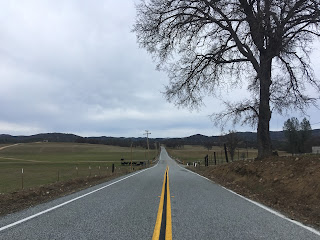
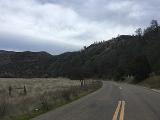
CA 130 for the next seven miles is on much more flat terrain but still has curves. CA 130 passes by Grant Lake heading east and how some nice hilly vistas looking towards Mount Hamilton. Mount Hamilton and the Lick Observatory can be seen below in the last photo.


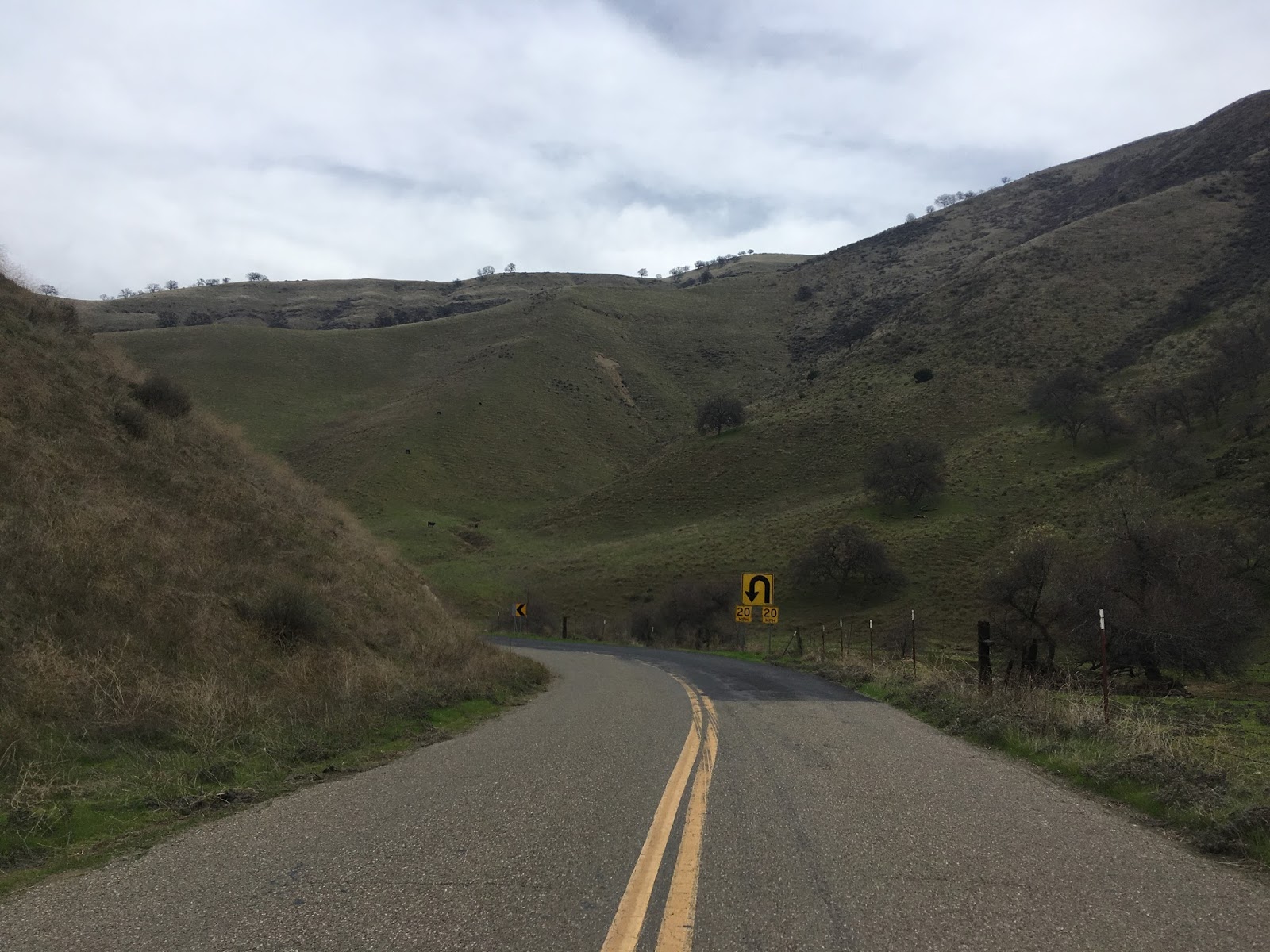
The final seven mile ascent to Mount Hamilton is about 2,200 feet above sea level and has one last CA 130 reassurance shield at Smith Creek.


The final climb to Mount Hamilton on CA 130 is no joke. The road is steep but the issue is more so the narrow roadway coupled with a lack of guard rail. The road is definitely not wide enough in places for two vehicles despite a center stripe being present. The switch-back cuts are obvious on the ascent uphill.


The final couple miles of the ascent has views of the Lick Observatory above CA 130. There is one final CA 130 shield at the entrance for the Observatory which is where the eastern terminus of the route is...at least according to Caltrans. The CA 130 shield indicates that there is no gas for 50 miles eastward.


The Lick Observatory was built from 1876 to 1887 after the completion of the Mount Hamilton Road. The Lick Observatory is the first permanently occupied mountain top observatory and is located at 4,209 feet above sea level at the top of Mount Hamilton. The Lick Observatory was responsible for locating half a dozen moons of Jupiter, several near-Earth objections, and way more than I'd be willing to list here. The importance of the observatory has lessened in the late 20th century with increasing light pollution from the San Francisco Bay Area. Many of the buildings are in a poor state of repair but there is apparently still has about twenty full-time residents.
Mount Hamilton and the eastern terminus of CA 130 is the start of San Antonio Valley Road. Interestingly Santa Clara County has developed it's own CA 130 shields and posts them on the entirety of San Antonio Valley Road. The traversable route for CA 130 continues east on San Antonio Valley Road but it is not state maintained which means essentially it is a Signed County Route.

There is a small parking area at the top of Mount Hamilton that overlooks San Francisco Bay and San Jose.

Parts of the observatory are everywhere at the top of Mount Hamilton. The Mount Hamilton School has been shuttered for over a decade, weird to see a real one-room school that was in use up to modern times.


San Antonio Valley Road isn't quite as curvy as Mount Hamilton Road but it is far from straight.


Copernicus Peak is actually higher than Mount Hamilton at 4,360 feet above sea level. The prominence is much higher at approximately 3,080 feet, so essentially the drop on San Antonio Valley Road is huge.

Speaking of the eastbound drop, it is steep and I mostly rode 2nd gear downhill. There are some switch-backs but there are fairly wide and the roadway is nowhere near as narrow as Mount Hamilton Road. This is a situation where the county maintained section of a highway is better than the Caltrans section.


San Antonio Valley Road drops to about 2,200 feet at a crossing of Isabel Creek and generally hangs within a few hundred feet of that elevation eastbound to Del Puerto Road. The one-lane bridge over Isabel Creek seems to be undergoing renovations to widen it to two-lanes which seems like a little bit of overkill given the remoteness of the area.


There are couple more switchbacks before the final drop to San Antonio Valley.


Another one of the Santa Clara County sourced CA 130 signs.

San Antonio Valley has a bunch of ranches and really not much else. There are some wide views of the mountains before San Antonio Valley Road swings north to meet Del Puerto Road. Traffic heading towards I-5 is directed onto Del Puerto Road.


Del Puerto Road has one more CA 130 sign before entering Stanislaus County. The quality of Del Pureto Road drops considerably in Stanislaus County.


Del Puerto Road follows Del Puerto Canyon and Creek towards San Joaquin Valley. The road is literally at the bottom of the canyon and snakes around the surrounding mountains. The canyons are nice to look at but the road is in rough shape. The mile markers are oddly painted on the roadway rather than placards.


Approaching San Joaquin Valley the mountains become grassy and devoid of trees. The lack of rain this far over the Diablos is very apparent.


Del Puerto Canyon widens out and the road ends at Diablo Grande Parkway. Parts of the lower canyon are heavily vandalized. I'm to understand that there were several drug farms in the lower canyon about a decade ago.


Diablo Grande Parkway becomes Sperry Avenue after crossing I-5. Sperry Avenue in Patterson is the traversable alignment of CA 130 east to CA 33. Most maps including the two I referenced from 1963 and 1964 show the proposed alignment continuing to 33.

Found a throw-back to the 1980s in Patterson before I jumped on I-5 southbound.

CAhighways.org had several stories about proposed expressways or freeways along the CA 130 corridor. The notion that a divided road would be possible over Mount Hamilton is a complete joke. There is no true mountain pass with Mount Hamilton and it apparently takes 365 curves to sustain a grade of less than 7%. It would seem that CA 130 will exist so long as the Lick Observatory stays open. The real oddity is that it is clear that Santa Clara County wants more out of CA 130 whereas the City of San Jose wants nothing to do with it.
The 1935 Division of Highways map of Santa Clara County shows the routing of LRN 115 in full detail. LRN 115 ended at 13th street which was the alignment of US 101E and CA 13/17 which is west of the current US 101 freeway.
1935 Santa Clara County Highway Map
As mentioned previously I took CA 130 westbound last year. The height of the cliffs was nowhere near as apparent given the stormy weather. Mount Hamilton apparently can get as much as 5 inches of snow in the winter months.
CA 130 Westbound
1963 State Highway Map
1964 State Highway Map
CAhighways.org on CA 130
CA 130 eastbound starts at US 101 along Alum Rock Avenue. There is some CA 130 shields on guide signs along US 101.


Unfortunately the City of San Jose seems to think that CA 130 doesn't need to be signed along Alum Rock Avenue. Back in 2011 the Alum Rock portion of CA 130 was turned over to the City of San Jose. Despite legislative language instructing that CA 130 shields shall remain for navigational purposes the city has yet to put any up. I'm not certain if CA 130 shields were present on Alum Rock Avenue prior to 2011. East of US 101 along CA 130 there is one major junction with I-680 before the route starts to climb into the Diablo Range.


After three miles on Alum Rock Avenue CA 130 turns on Mount Hamilton Road where the first reassurance shield is located. Mount Hamilton Road was completed back in 1876 for access to the Lick Observatory. Mount Hamilton Road is very popular with cyclists as it climbs to over 4,000 feet upon grades that rarely exceed 7%. There are various accurately descriptive warnings to oversized vehicles not to take Mount Hamilton Road.


Even near San Jose the initial five miles of Mount Hamilton Road is narrow and curvy. Traveling eastbound is far more difficult due to the road being on the cliff-face most of the way up to Mount Hamilton. There are no "official" overlooks but there some beautiful views of downtown San Jose and San Francisco Bay.


CA 130 for the next seven miles is on much more flat terrain but still has curves. CA 130 passes by Grant Lake heading east and how some nice hilly vistas looking towards Mount Hamilton. Mount Hamilton and the Lick Observatory can be seen below in the last photo.


The final seven mile ascent to Mount Hamilton is about 2,200 feet above sea level and has one last CA 130 reassurance shield at Smith Creek.


The final climb to Mount Hamilton on CA 130 is no joke. The road is steep but the issue is more so the narrow roadway coupled with a lack of guard rail. The road is definitely not wide enough in places for two vehicles despite a center stripe being present. The switch-back cuts are obvious on the ascent uphill.


The final couple miles of the ascent has views of the Lick Observatory above CA 130. There is one final CA 130 shield at the entrance for the Observatory which is where the eastern terminus of the route is...at least according to Caltrans. The CA 130 shield indicates that there is no gas for 50 miles eastward.


The Lick Observatory was built from 1876 to 1887 after the completion of the Mount Hamilton Road. The Lick Observatory is the first permanently occupied mountain top observatory and is located at 4,209 feet above sea level at the top of Mount Hamilton. The Lick Observatory was responsible for locating half a dozen moons of Jupiter, several near-Earth objections, and way more than I'd be willing to list here. The importance of the observatory has lessened in the late 20th century with increasing light pollution from the San Francisco Bay Area. Many of the buildings are in a poor state of repair but there is apparently still has about twenty full-time residents.
Mount Hamilton and the eastern terminus of CA 130 is the start of San Antonio Valley Road. Interestingly Santa Clara County has developed it's own CA 130 shields and posts them on the entirety of San Antonio Valley Road. The traversable route for CA 130 continues east on San Antonio Valley Road but it is not state maintained which means essentially it is a Signed County Route.

There is a small parking area at the top of Mount Hamilton that overlooks San Francisco Bay and San Jose.

Parts of the observatory are everywhere at the top of Mount Hamilton. The Mount Hamilton School has been shuttered for over a decade, weird to see a real one-room school that was in use up to modern times.


San Antonio Valley Road isn't quite as curvy as Mount Hamilton Road but it is far from straight.


Copernicus Peak is actually higher than Mount Hamilton at 4,360 feet above sea level. The prominence is much higher at approximately 3,080 feet, so essentially the drop on San Antonio Valley Road is huge.

Speaking of the eastbound drop, it is steep and I mostly rode 2nd gear downhill. There are some switch-backs but there are fairly wide and the roadway is nowhere near as narrow as Mount Hamilton Road. This is a situation where the county maintained section of a highway is better than the Caltrans section.


San Antonio Valley Road drops to about 2,200 feet at a crossing of Isabel Creek and generally hangs within a few hundred feet of that elevation eastbound to Del Puerto Road. The one-lane bridge over Isabel Creek seems to be undergoing renovations to widen it to two-lanes which seems like a little bit of overkill given the remoteness of the area.


There are couple more switchbacks before the final drop to San Antonio Valley.


Another one of the Santa Clara County sourced CA 130 signs.

San Antonio Valley has a bunch of ranches and really not much else. There are some wide views of the mountains before San Antonio Valley Road swings north to meet Del Puerto Road. Traffic heading towards I-5 is directed onto Del Puerto Road.


Del Puerto Road has one more CA 130 sign before entering Stanislaus County. The quality of Del Pureto Road drops considerably in Stanislaus County.


Del Puerto Road follows Del Puerto Canyon and Creek towards San Joaquin Valley. The road is literally at the bottom of the canyon and snakes around the surrounding mountains. The canyons are nice to look at but the road is in rough shape. The mile markers are oddly painted on the roadway rather than placards.


Approaching San Joaquin Valley the mountains become grassy and devoid of trees. The lack of rain this far over the Diablos is very apparent.


Del Puerto Canyon widens out and the road ends at Diablo Grande Parkway. Parts of the lower canyon are heavily vandalized. I'm to understand that there were several drug farms in the lower canyon about a decade ago.


Diablo Grande Parkway becomes Sperry Avenue after crossing I-5. Sperry Avenue in Patterson is the traversable alignment of CA 130 east to CA 33. Most maps including the two I referenced from 1963 and 1964 show the proposed alignment continuing to 33.

Found a throw-back to the 1980s in Patterson before I jumped on I-5 southbound.

CAhighways.org had several stories about proposed expressways or freeways along the CA 130 corridor. The notion that a divided road would be possible over Mount Hamilton is a complete joke. There is no true mountain pass with Mount Hamilton and it apparently takes 365 curves to sustain a grade of less than 7%. It would seem that CA 130 will exist so long as the Lick Observatory stays open. The real oddity is that it is clear that Santa Clara County wants more out of CA 130 whereas the City of San Jose wants nothing to do with it.
The 1935 Division of Highways map of Santa Clara County shows the routing of LRN 115 in full detail. LRN 115 ended at 13th street which was the alignment of US 101E and CA 13/17 which is west of the current US 101 freeway.
1935 Santa Clara County Highway Map
As mentioned previously I took CA 130 westbound last year. The height of the cliffs was nowhere near as apparent given the stormy weather. Mount Hamilton apparently can get as much as 5 inches of snow in the winter months.
CA 130 Westbound
Comments