Bridges of the Lackawanna Railroad: Paulinskill Viaduct (Hainesburg, NJ)

The early 1900s was a period of great expansion and construction when it comes to America’s railroads. During the period of 1909-1915, the Delaware, Lackawanna, & Western Railroad (or DL&W, or Lackawanna for short) oversaw the construction of four monstrous reinforced concrete bridges across northwest New Jersey and northeast Pennsylvania to serve its new Lackawanna Cut Off and Summit Cut Off tracks along the New York to Binghamton freight rail service. In due course, we’re going to discuss these four landmark structures, their local/regional significance, and how you can view & experience them up close (legally) for yourself.

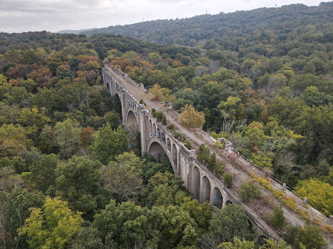
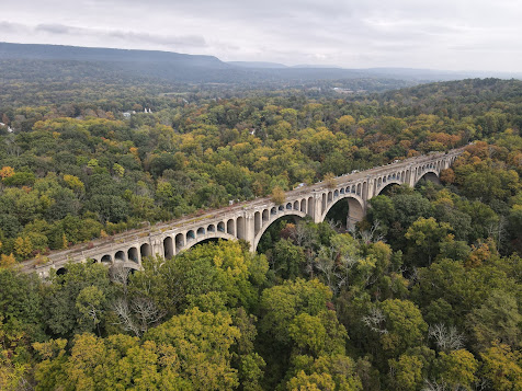
We’ll begin near the town of Hainesburg, NJ and the Paulinskill Viaduct, located a short distance from NJ Route 94 a few miles east of Columbia. Built in 1910, this bridge spans the Paulins Kill Valley with an overall length of about 1,100 ft with a height of up to 115 ft above the valley floor. To help span the valley, it features seven concrete arch spans of 120 ft each. It was the largest reinforced concrete bridge in the world when built, surpassing its nearby counterpart on the Delaware River. Since reinforced concrete was not yet a widespread building material, this bridge’s construction made headlines within the global engineering community for its groundbreaking widespread use of the material. It has proven to be an extremely durable and strong structure that continues to stand the test of time over a century after being built.

The Paulinskill Viaduct carried rail traffic into the 1970s, when the line was finally abandoned and the bridge fell into disrepair. The train tracks and rail bed were removed in the 1980s and no other modifications have been made to the structure since. Plans are currently in the works to restore this bridge to its former glory be reinstating passenger rail service along the Lackawanna Cut Off as part of a proposed commuter rail line extension toward Stroudsburg and Scranton, however nothing appears to be imminent on that front at this time.

Long popular with urban explorers since its abandonment in the 1980s, this bridge is difficult to view in full from ground level – it requires legal aerial photography methods in order to fully take in the scale of this structure. Even so, mother nature has gradually overtaken this bridge in the past century with much of the structure now shrouded or hidden by the surrounding wilderness, which makes it difficult to appreciate the size of the structure in its expansive location. In response to the long-time problems in the area with trespassers, the New Jersey State Police is said to patrol the area on a regular basis. The most legal and straight-forward way to explore this bridge is to view it from Station Road a short distance south of NJ 94 in Hainesburg. The road passes beneath the structure and is home to multiple roadside interpretive signs outlining the history of the area and its signature bridge.

The photos you're about to look through below were all taken legally with the use of a quadcopter drone. Always remember to explore your favorite landmarks in a safe, legal, and responsible manner.


How to Get There:

Comments

Popular posts from this blog

Dillon Road

Dillon Road is a 34.2-mile highway located in northern Coachella Valley of Riverside County, California.  Dillon Road begins at Avenue 48 on the outskirts of Indio and ends to the west at California State Route 62 near San Gorgonio Pass.  Dillon Road was developed the 1930s as a construction road for the Colorado River Aqueduct.  Dillon Road serves as a northern bypass to much of the development of Coachella Valley.  Dillon Road is known for it's frequent dips and spectacular views of San Gorgonio Pass.   Part 1; the history of Dillon Road Dillon Road was constructed as a haul road for the Colorado River Aqueduct through Coachella Valley.  The Colorado River Aqueduct spans 242 miles from Parker Dam on the Colorado River west to Lake Mathews near Corona.  Construction of the Colorado River Aqueduct began during January 1933 near Thousand Palms and was made functional on January 7, 1939.  West of Berdoo Canyon Road the alignment of Dillon Road is largely concurrent with the Colorado

Tehachapi-Willow Springs Road

Tehachapi-Willow Springs Road is an approximately 21-mile highway located in southeast Kern County.  Tehachapi-Willow Springs Road begins at Tehachapi Boulevard (former US Route 466) in Tehachapi and crosses the Tehachapi Mountains via the 4,820-foot-high Oak Creek Pass.  Tehachapi-Willow Springs Road enters Antelope Valley of the wider Mojave Desert and passes by the historic stage station of Willow Springs to a southern terminus at Rosamond Boulevard.  Tehachapi-Willow Springs Road has historic ties to the Havilah-Los Angeles Road and Stockton-Los Angeles Road due to the once reliable presence of water at Willow Springs. Part 1; the history of Tehachapi-Willow Springs Road Oak Creek Pass and Willow Springs were known to the local tribes of the Tehachapi Mountains for generations.  The first documented European crossing of Oak Creek Pass was during 1776 as part of an expedition by Francisco Garces.  Oak Creek Pass is as used again by John C. Fremont during an 1844-1845 expedition to e

Former California State Route 152 east of Pacheco through the San Luis Reservoir

Dinosaur Point Road east of Pacheco Pass to the waters of the San Luis Reservoir is the original alignment of California State Route 152.  Since July 1965, California State Route 152 has been realigned east of Pacheco Pass via a modernized expressway.  The original alignment of California State Route 152 on occasion reemerges from the San Luis Reservoir at Dinosaur Point.  Pictured above as the blog cover is the original alignment of California State Route 152 at Dinosaur Point disappearing eastward into the waters of the San Luis Reservoir.  Below California State Route 152 can be seen passing through what is now the San Luis Reservoir east of Pacheco Pass on the 1935 Division of Highways Map of Merced County. Part 1; the history of California State Route 152 east of Pacheco Pass through the San Luis Reservoir site The present site of the San Luis Reservoir during the era of Alta California was part of Rancho San Luis Gonzaga.  Rancho San Luis Gonzaga was granted to Francisco Jose Riv