
South Point Road


South Point Road is 10.7-mile rural roadway located on the southern tip of the Hawaiian Big Island.  As the name suggests the corridor accesses South Point (Ka Lae) which is the southernmost point in the fifty U.S. states.  The largely one-lane South Point Road was constructed to facilitate overland travel from Mamalahoa Highway to a lighthouse facility constructed during 1906-1908.  South Point Road has never had a Hawaii Route designation and is mostly carried by a single lane of asphalt.  


This page is part of the Gribblenation Hawaii Roads series.  A compellation of all Hawaii-related media from both Gribblenation and RoadwayWiz can be found by clicking here


Part 1; the history of South Point Road

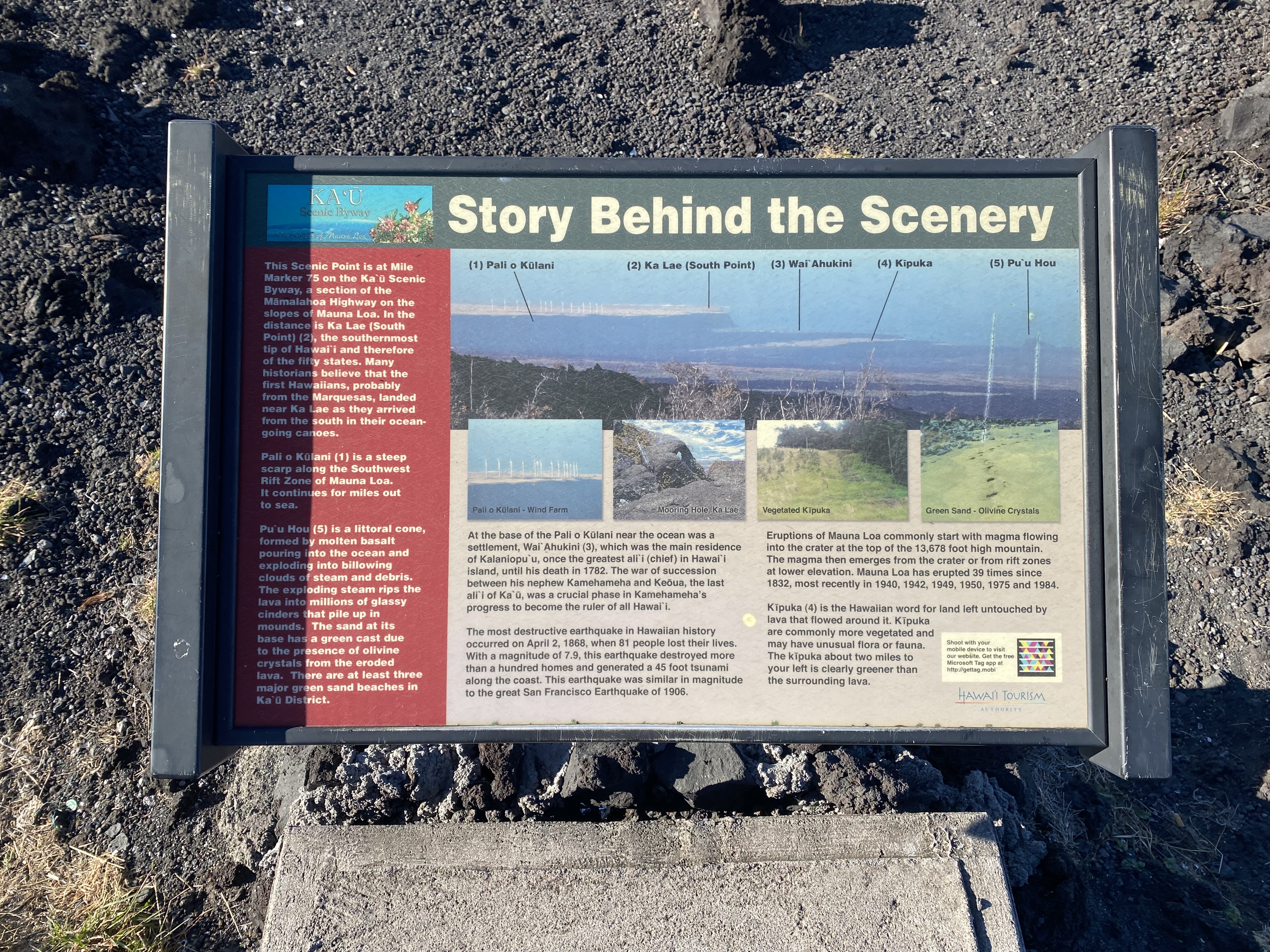
South Point is known as Ka Lae (alternatively Kalae) in the Hawaiian language and is located at the southern tip of the Big Island.  As the name implies South Point is geographically the southernmost point in the fifty U.S. states.  

South Point is known to be the site of one of the earliest Polynesian settlements on the Hawaiian Islands.  It is generally thought to be the site of the first Polynesian landing in Hawaii due to the Big Island being the closest located to Tahiti.  Ruins of a Hawaiian heiau (temple) and a fishing shrine are known to exist the area.  

A lighthouse was opened at South Point during March 1906.  During 1908 the United States Coast Guard would construct a home site for a groundskeeper.  A roadway was also constructed to the lighthouse which connected it to the Mamalahoa Highway near Waiohinu.

South Point Road can be seen terminating at the tip of the Big Island on the 1924 United States Geological Survey map of Kalae.  


A steel tower would be erected to boost the height of the South Point Lighthouse in 1929.  The location would become a major point of tourist interest during the early automotive era on the Big Island due to the geographic significance.  The South Point Lighthouse is displayed as a major destination on the 1930 Hilo Chamber of Commerce map of the Big Island


During 1941 amid World War II Morse Field was constructed as an Army Air Field.  An active military base was in service at the location until 1948 when it was declared surplus.  Until 1953 the South Point Air Force Station would remain in use as an emergency runway facility.  

The Hawaii Route System was expanded to the Big Island during 1955.  Despite the tourism notoriety South Point Road would not be assigned as one of the initial Big Island Hawaii Routes.  Despite not having a route designation South Point Road appears as a major roadway on the 1959 Gousha Highway map of Hawaii.   


South Point was one of the final sites to be considered by NASA to launch rockets into space.  Ultimately the location was determined to be far too remote and instead was repurposed into a space tracking station which operated under Air Force command from 1964-1965.  A radar tower would be maintained at South Point until 1983.  

South Point Road is maintained as part of Federal Aid Program 150 according to the 2012 Hawaii Department Transportation listing.  The list notes that the desired classification was proposed to be downgraded to a Local corridor due to low use.  The notes also stipulate that part of South Point Road was designated at the time as four-wheel-drive only.  


Part 2; a drive along South Point Road

South Point is viewable from a vista located on Hawaii Route 11 (Mamalahoa Highway) near the community of Ocean View.


South Point Road begins at Hawaii Route 11 near Waiohinu.  Traffic is advised South Point itself is 12 miles from Hawaii Route 11.  


Much of South Point Road is a single lane wide but paved.  As of 2024 Enterprize Rental Car advises not to drive South Point Road on their Big Island map but does not outright prohibit it.  The highway can be seen below is a series of Josh Schmid photos.  


South Point can be seen below (Josh Schmid photo). 


The return trip northbound on South Point Road (Josh Schmid photo). 


Comments

Popular posts from this blog

2018 Mojave Road Trip Part 2; The deadly desert highway (California State Route 127 and Nevada State Route 373)

After leaving Barstow via Old Highway 58 my next destination was in Death Valley.  To access Death Valley from rural San Bernardino County required a trek on north on Interstate 15 to California State Route 127 which becomes Nevada State Route 373 at the state line. Along I-15 I encountered the road sign oddity that is Zzyzx Road about eight miles south of Baker.   Zzyzx Road is a four mile road that used to go to the Zzyzx Mineral Springs and Health Spa.   The spa was founded in the 1940s and the owner made up the name "Zzyzx" to claim it was the last word in the English Language.  The spa has been shut down since the 1970s and is now part of a Desert Studies Center for California State University. The southern terminus of CA 127 in Baker is located at I-15 exit 246.  CA 127 is a 91 mile north/south highway which runs to the Nevada State Line in Inyo County.  CA 127 is called Death Valley Road from I-15 northward.  South of CA 127 ...

Finding the Pre-Emption Road of New York State

  The Pre-Emption Road (or rather a series of roads named Pre-Emption Road) follows a survey line called the Pre-Emption Line, drawn in the early days of the United States. The story begins with Massachusetts and New York having competing land claims to modern day Western New York State that have their roots in colonial charters granted by the British. After the Revolutionary War ended, this land became the frontier of the nation and its settlement became a priority for the new American government. During this era, there were a lot of competing land claims that needed to be settled. It was no different with the land claims between New York State and Massachusetts. On November 30, 1786, Massachusetts and New York sent representatives to Hartford, Connecticut to resolve their competing land claims. In less than three weeks, the representatives had reached a compromise. Massachusetts would receive pre-emption rights, meaning the right to sell the land after the Indian title ...

What's In a Name?: When the Roads Really Do Tell a Story

  Our tagline on the Gribblenation blog is "because every road tells a story". Some roads tell different stories than others. Along our travels, we may see historic markers that tell us a little story about the roads we travel or the places we pass by. Some historic markers are more general, as to telling us who lived where or what old trail traversed between two towns. During my travels across New York State and other states or provinces, I pass by many historic markers, some with interesting or amusing references to roads. I wanted to highlight a few of the markers I've seen along my travels around the Empire State and help tell their stories. Those stories may be as specific as explaining the tales of a tree that was used to help measure a distance of eight miles from Bath to Avoca in Steuben County, as referenced on the Eight Mile Tree historical marker above. They may also help point the way along historical roads first used centuries ago, or may help tell a local l...