Earlier this month, I had the opportunity to visit South Korea. It was a work trip, but I did have a day to explore Seoul. This was my first time in Asia, so I was excited to experience the culture, explore the landscape, and of course enjoy the food!
My flickr album from Seoul
is here.
On Sunday, while I was in Seoul - I embarked on a full-day city tour. The tour included transportation and an English-speaking tour guide. One of the great things was the diversity of the tour group - we had a couple from India, a couple from Kuwait, a father-and-son from China, an American military family recently stationed in Korea, and two friends from the US - interestingly, one of the two friends lives in Chapel Hill which is approximately two hours from where I live in Charlotte.
 |
| The race event that was taking place outside of Seoul Plaza. |
Our group met outside the Seoul City Hall Subway Station. At the same time, a distance running event was taking place on the streets of Seoul. A glimpse of the hectic everyday life in Seoul.
Jogyesa Temple:
 |
| The colorful Jogyesa Temple. |
Our first stop was Jogyesa Temple. Located in Downtown Seoul, the Buddhist Temple is an important symbol of Korean Buddhism. It is the head temple of the Jogye Order of Korean Buddhism.
The temple was established at the start of the Joseon Dynasty in 1395. The current temple was built in 1910 - moved to its current location in 1937 - and reconstruction completed in 1938.
The centerpiece of the grounds is the Daeungjeon (Main Dharma Hall). Daeungjeon is the largest temple building within the city of Seoul. In 2000, Daeungjeon was designated an important cultural asset in Korea.
Jogyesa Temple is playful, full of color, and a spiritual site. The landscape is full of flowers, lanterns, and topiaries in fantastic colors. Playful depictions of Buddha can't help but make you smile. Inside Daeungjeon, people of all faiths can share their spirituality in a brief prayer.
Gyeongbokgung Palace:
 |
| Gwanghwamun Gate is the largest and the main gate at Gyeongbokgung Palace. |
The highlight of the tour was Gyeongbokgung Palace. The palace grounds date back to 1395 and have survived centuries of wars and foreign occupations. Nearly all of the palace grounds were destroyed during the period of Japanese occupation from 1910-1945. Since the end of the Korean War, much of the palace grounds have been restored.
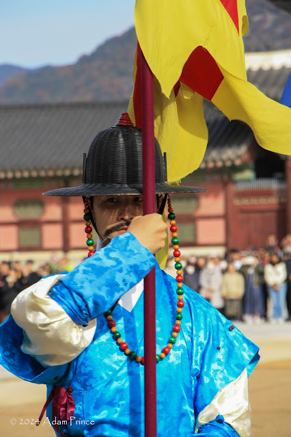
 |
| The changing of the royal guard ceremony is a must-see when in Seoul. |
Immediately after passing through the massive Gwanghwamun Gate sits a large parade ground. Here, the changing of the palace royal guard re-enactment is a must-watch. The precise, colorful, and enjoyable ceremony will certainly capture your attention. The re-enactment occurs twice daily, at 10 am and 2 pm.
 |
| Heungnyemun Gate was built in 1426. The Japanese Government built their General Government Building at this site in 1926. It was torn down in 1996. The gate was rebuilt/restored in 2001. |
 |
| Geonjeongjeon Hall was the main throne hall of the palace. |
The palace grounds are massive - as there are numerous gates, halls, pavilions, and more throughout. The restoration of Gyeongbokgung Palace has been an ongoing project of the South Korean government - additional buildings are planned to be rebuilt and restored.
 |
| Gyeonghoeru Pavilion |
My favorite location was the Gyeonghoeru Pavilion. The pavilion, where, along with other important events, was where foreign visitors were entertained, is surrounded by a reflecting pond. Witnessing the simple beauty of this pavilion backed against a blue sky is something I'll carry with me for a long time.
 |
| One of the exhibits inside the National Folk Museum of Korea. |
It is easy to spend a large portion of the day, if not all, at Gyeongbokgung Palace. There's just so much to see. Within the palace grounds are two museums, the
National Folk Museum of Korea and the National Palace Museum of Korea. During our tour, we spent a brief time inside the National Folk Museum. We walked through the permanent museum exhibit on Korean family traditions from birth to death.
Following the National Folk Museum, we headed to the Ginseng Museum and Marketplace. Photos were not allowed here. The museum explains how ginseng is farmed and its importance to Korea. After the guided walk-through, there is a marketplace where you can purchase many different forms of ginseng.
 |
| Bulgogi for lunch - my first taste of Korean food. |
Next was lunch at the Insadong Market. Here was my first chance to locate and find some Korean food. For a first timer like me, it is a little intimidating to know what to eat, let alone where to eat. Fortunately, our tour guide suggested a few places, and I went to a small restaurant and had some bulgogi. The beef bulgogi I had was excellent and just a sampling of the great food I would enjoy the rest of the week.
N Seoul Tower:
Following lunch, it was off to N Seoul Tower. Getting there was interesting. The tower is one of the more popular attractions in Seoul - for visitors and locals. Because the cable car ride was experiencing a two-hour wait, we were dropped off at a bus terminal and took a Seoul public bus to near the top of the mountain where the tower sits.
 |
| The endless urban landscape of Seoul snakes its way through the valleys. |
 |
| Love locks are a popular permanent memento at the tower. |
After a short yet steep walk, we arrived at the top of the hill, and the views did not disappoint. It is here where Seoul's expansive size really can be seen. The seemingly endless sea of Seoul's urban landscape is impressive. While I didn't get into the tower, you can still take in 360-degree views of the city from anywhere.
 |
| A busy Namdaenum Market. |
We did take the cable car down from the tower. From there, it was a short drive to Namdaemun Market. Namdaemun Market has a variety of shops for clothing, toys, and other souvenirs. While it was late afternoon and some shops were closing, the market streets were still busy, and it was a great example of a more traditional Korean market.
 |
| Seoul Plaza and the surrounding skyline. The glass building on the left is Seoul City Hall - in front of it is Seoul Public Library - which was the old City Hall. |
After about 45 minutes at Namdaemun Market, we returned to City Hall and ended our tour. I spent some time walking around Seoul Plaza - where the day before, it hosted a Library in the Park with the Seoul Public Library. The Plaza was home to the race event that morning, and the next morning, crews would begin preparing it for a public ice-skating rink.
 |
| The alleyway where we had the first of many Korean BBQ experiences. |
I then returned to my hotel to rest before meeting colleagues for dinner. We found a hole-in-the-wall Korean BBQ restaurant down a local alley. It was simply delicious. Throughout the week, I would thoroughly enjoy the different ways Korean BBQ can be served. What made dinner enjoyable was a retired couple from California who sat next to us. They were on a three-week tour of Asia, and hearing their stories, along with enjoying dinner, made for a great first-day experience in Seoul.


Comments