
The history of the US Route System in Las Vegas, Nevada


The city of Las Vegas, Nevada since the inception of the US Route System in 1926 has been a hub of the overall system.  Las Vegas was initially a served only by US Route 91 but would be joined by US Routes 466, 93 and 95 before the end of the 1930s.  Much of the US Route System in Las Vegas historically has been tied to the corridors of Las Vegas Boulevard and Fremont Street.  Despite the passage of time and emergence of the Interstate System the city of Las Vegas remains an important waypoint on the US Route System.  This blog will examine the history of the US Route System in Las Vegas from the end of the Auto Trail era to modern times.  

The US Routes can be seen passing through downtown Las Vegas below as depicted on the 1956 Gousha Highway Map of Nevada.


Part 1; the history of the US Route System in Las Vegas

Las Vegas Valley prior to European settlement is known to have been inhabited by Native Tribes for at least 10,000 years.  Around approximately 700 the Paiute began to inhabit Las Vegas Valley during winter months at the Big Springs (located along modern-day Valley View Boulevard).  

During 1829 a trade caravan led by Spanish merchant Antonio Armijo made the first documented European crossing of Las Vegas Valley.  The party was looking to establish a trade route to Los Angeles and happened upon Las Vegas Valley following a tributary of the Colorado River.  Armijo determined that Las Vegas Valley was the ideal supply point for travel into California given reliable sources of water could be found.  The name "Las Vegas" translated from Spanish into English means "Fertile Plains." 

During May 1844 John C. Fremont led a U.S. Army expedition through Las Vegas Valley.  Fremont had been appointed by President John C. Tyler to scout the area for a potential fortification in preparation for a war with Mexico.  The fortification constructed by Fremont's men was located at Big Springs.  

The Mormon Road was scouted by a party led by Jefferson Hunt which was searching for a supply route from Salt Lake City to Southern California during 1847-1848.  Following the conclusion of the Mexican-American War the Mormon Road would be solidified as a major overland route.  

The Mormon Road south from Utah passed through Las Vegas Valley into California towards Cajon Pass.  The Mormon Road was later reorganized and improved into the Los Angeles-Salt Lake Trail by 1855.  During the same year twenty-nine missionaries from Utah would establish an adobe fort at what is now the corner of Las Vegas Boulevard and Washington Avenue.  The Los Angles-Salt Lake Trail which can be seen passing through New Mexico Territory on the 1857 Britton & Rey's Map of California.  

The Mormons would abandon their fort in Las Vegas Valley during 1857 and return to Utah.  The fort was reoccupied during 1865 by a party led by Octavius Gass.  The Paiute had negotiated a treaty with the Federal government which ceded the land around the fortification in Las Vegas.  Gass's stakes came to be known as "Rancho Las Vegas."  

Nevada became a State during October of 1864 but did not include much of what was is now Clark County.  Much of modern Clark County became part of Pah-Ute County of Arizona Territory in 1865.  Much of Pah-Ute County of Arizona Territory was transferred to the State of Nevada in January of 1867.  The Los Angeles-Salt Lake Trail can be observed passing through Las Vegas which was then part of Lincoln County on the 1873 Bancroft's Map of California, Nevada, Utah and Arizona.  The Los-Angeles-Salt Lake Trail was also a component of the larger Old Spanish Trail which originated in Santa Fe, New Mexico.  

In 1881 Gass lost Rancho Las Vegas which was subsequently purchased by Archibald Stewart.  Stewart's wife Helen would become the first postmaster of Las Vegas during 1884.  Archibald Stewart would be murdered during 1884 but the property would remain with his family following his death.  In 1895 the first large scale Mormon migration to Las Vegas Valley took place.  The 1,800-acre property owned by the Archibald family was sold to the San Pedro, Los Angeles & Salt Lake Railroad in 1902.  

By 1905 the San Pedro, Los Angeles & Salt Lake Railroad had completed their new line through Las Vegas.  On May 15, 1905, the railroad auctioned off 110 acres at a new subdivided town plot which now comprises downtown Las Vegas.  The original plot of Las Vegas can be seen centered around Main Street (now Las Vegas Boulevard north of downtown), 5th Street (now Las Vegas Boulevard) and Fremont Street on the 1907 United States Geological Survey Map of Las Vegas.


Clark County was spun off from southern Lincoln County on July 1, 1909, with Las Vegas being selected as the new seat.  Las Vegas would incorporate as a city on March 16, 1911.

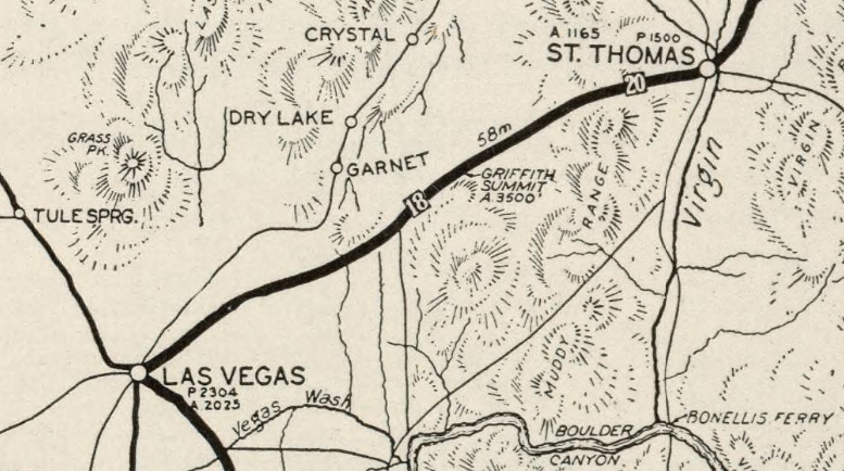
A primitive automotive road was constructed immediately south of sandstone formations which now comprise Valley of Fire State Park in 1912 towards Las Vegas Valley.  This early automotive road was incorporated into the Arrowhead Trail when the Arrowhead Trails Association was founded during December of 1916.  The 1917 Arrowhead Trail Map shows the namesake Auto Trail heading southwest from St. Thomas via what is now Valley of Fire State Park towards Las Vegas via Griffith Summit of the Muddy Mountains.  The Arrowhead Trail south of Las Vegas climbed through Railroad Pass towards Bannock, California via Searchlight.  

The 1919 Nevada Department of Highways Map shows the Arrowhead Trail heading southwest from St. Thomas towards Las Vegas through what is now Valley of Fire State Park as a primary highway.  The Arrowhead Trail was designated as Nevada State Route 6 from the Arizona State Line southwest to Las Vegas by the Nevada Legislature in 1919.  The Arrowhead Trail originally followed Nevada State Route 5 south from Las Vegas towards Searchlight and the California State Line.  

By 1920 the "Silver Lake Cutoff" of the Arrowhead Trail was proposed as a means of to saving 90 miles by connecting the highway from Las Vegas directly southwest to Dagget, California.  The Silver Lake Cutoff was similar to the previous Los Angeles-Salt Lake Road but followed a more northern path to utilize the Tonopah & Tidewater Railroad siding of Silver Lake as a waypoint.   This new routing of the Arrowhead Trail via the Silver Lake Cutoff was ultimately paved with oiled earth in 1925 by San Bernardino County.  Within California the Silver Lake Cutoff would become an extension of Legislative Route Number 31 during 1925. 

The 1924 Rand McNally Map of California and Nevada displays the Arrowhead Trail in addition to Evergreen National Highway traveling through Valley of Fire to Las Vegas.  The Arrowhead Trail and Evergreen National Highway can be seen climbing Griffith Summit southwest of Valley of Fire.  The Arrowhead Trail and Evergreen National Highway are shown to branch in downtown Las Vegas at the intersection of 5th Street/Fremont Street.  The Arrowhead Trail followed Las Vegas Boulevard (Nevada State Route 6) south to Jean and into California via Good Springs.  The Evergreen National Highway is shown utilizing Fremont Street (Nevada State Route 5) towards Railroad Pass and Searchlight. 


The 1925 Rand McNally Junior Map of California shows Nevada State Route 6 and the Arrowhead Trail realigned via a new graded road from Mesquite-Las Vegas via Apex Summit.  This new realignment of Nevada State Route 6 and the Arrowhead Trail had been completed in 1924 over Apex Summit.   The previous route of Nevada State Route 6/Arrowhead Trail through; St. Thomas, Valley of Fire and Griffith Summit is shown as a rural ungraded road.  The 1925 Rand McNally Junior Map shows proposed US Route 91 following Nevada State Route 6 and Nevada State Route 5 through Las Vegas towards Bannock, California.  

The US Route System wouldn't be created until November 11, 1926, when it the final system drafted by the American Association of State Highway Officials (AASHO) was approved by the Secretary of Agriculture.  The initial description of US Route 91 displays it following the established path of Nevada State Route 6 and the Arrowhead Trail.   US Route 91 passed through Las Vegas southbound via Main Street (now Las Vegas Boulevard north of downtown), 5th Street in downtown (now Las Vegas Boulevard) and Las Vegas Boulevard to the California state line past Jean.  Unlike the early Silver Lake Cutoff, the routing of US Route 91 bypassed Good Springs of favor entering California near Primm.  


US Route 91 is displayed as concurrent with Nevada State Route 6 and the Arrowhead Trail on the 1927 Nevada Department of Highways Map.  


During June 1933 the California Division of Highways petitioned the American Association of State Highway Officials (then AASHO, now AASHTO) for an extension of US Route 64 west of Raton, New Mexico to Morro Bay, California.  The extension of US Route 64 was not considered ideal by AASHO due to proposed routing including a lengthy multiplex of US Route 66 from Santa Fe, New Mexico to Barstow, California.  An alternate proposed routing of US Route 64 in New Mexico did little to mitigate the lengthy multiplex of US Route 66 in Arizona.  The proposal to extended US Route 64 was to be reviewed by the AASHO Executive Committee during their October 1933 meeting.  


During their August 1933 meeting AASHO suggested US Route 466 to the California Division of Highways as an alternative to the lengthy extension of US Route 64.  US Route 466 was initially proposed as originating in Barstow, California and terminating at Morro Bay.  The Division of Highways via telegram to AASHO dated August 10, 1933, expressed that such a short US Route located entirely in-state would not provide the same utility as their US Route 64 extension proposal.  

 
During the October 1933 AASHO meeting a compromise was reached which brought US Route 466 into existence.  US Route 466 would begin at US Route 66 in Kingman, Arizona and travel northwest to the site of Boulder Dam at the Nevada state line.  Within in California, US Route 466 would retain the same Barstow-Morro Bay alignment desired by the California Division of Highways for their US Route 64 extension proposal.  

The first description of US Route 466 in Nevada is a letter dated November 14, 1933.  In said letter the Nevada State Highway Engineer describes the routing of US Route 466 to the AASHO Executive Secretary.  The origin point of US Route 466 is stated to be from the site of Boulder Dam westerly via Nevada State Route 26 and Nevada State Route 5 to Las Vegas via Fremont Street where it met US Route 91 at 5th Street.  From Las Vegas, US Route 466 multiplexed US Route 91 along Nevada State Route 6 to the California state line at Primm.  US Route 466 would continue to multiplex US Route 91 in California to Barstow where it would branch off towards Morro Bay.  


The 1935 Nevada Department of Highways Map is the first to display US Route 466 in the state.  Nevada State Route 26 is shown to be truncated as running between Nevada State Route 5 and Boulder City.  Nevada State Route 42 is shown have replaced Nevada State Route 26 east of Boulder City to the Boulder Dam construction site.  


During May 1935 the Arizona State Highway Department and Nevada Department of Highways submitted a joint request to AASHO to extend US Route 93 from Glendale, Nevada to Kingman, Arizona by way of Boulder Dam.  


A letter from the AASHO Executive Secretary to the Nevada and Arizona State Highway Engineers dated September 7, 1935, confirmed US Route 93 had been officially extended from Glendale, Nevada to Kingman, Arizona.  From Glendale south to downtown Las Vegas the routing of US Route 93 was concurrent with US Route 91.  The routing US Route 93 south of Las Vegas to Kingman via Boulder Dam was completely concurrent with US Route 466.  


US Route 93 first appears extended through Las Vegas to the Arizona state line at Boulder Dam on the 1937 Nevada Department of Highways Map.  


In a letter dated October 4, 1938, the Nevada State Highway Engineer requested information from the AASHO Executive Secretary pertaining to a 1937 request to extend US Route 95 through Nevada.  The origin point for the proposed extension of US Route 95 is shown to be the Idaho, Oregon, Nevada Highway (ION Highway) at McDermitt at the Oregon/Neveda State Line.  The AASHO Executive Secretary replied on October 8, 1937, indicating that the Oregon Department of Transportation stated ION. Highway #456 was not ready to facilitate automotive travel.  The AASHO Executive Committee's opinion was to hold off on the extension of US Route 95 until ION Highway #456 was completed in Oregon.  


The 1939 Nevada Department of Highways Map shows alterations to the US Route System in downtown Las Vegas.  Mainline US Route 91 is displayed as being realigned onto Main Street whereas US Route 91 Alternate is shown designated over 5th Street.  Mainline US Route 93 is shown realigned onto Main Street north of Fremont Street whereas US Route 93 Alternate is displayed on 5th Street.  Mainline US Route 466 is shown realigned onto Main Street south of Fremont Street whereas US Route 466 Alternate is shown on 5th Street.  Both mainline US Route 93 and US Route 466 are showing branching east of Main Street via Fremont Street.  None of these Alternate US Route alignments in downtown Las Vegas appear to have ever been submitted to or approved by AASHO. 


On May 20, 1939, the Nevada State Highway Engineer again petitioned the AASHO Executive Committee to extend US Route 95 into Nevada.  The Nevada State Highway Engineer noted Nevada State Route 8 had been fully paved from Winnemucca to the Oregon State Line since 1936 and was ready to be assigned as US Route 95 despite ION Highway #456 not being completed.  


The Nevada State Highway Engineer's letter was met with a reply by the AASHO Executive Secretary on May 24, 1939.  The Executive Secretary stated once notification of the completion of ION Highway #456 was received from the Oregon Department of Transportation the AASHO Executive Committee would likely take action to extend US Route 95.


A letter dated June 2, 1939, from the AASHO Executive Secretary to the State Highway engineers of; California, Nevada, Oregon and Idaho noted the proposed alignment of US Route 95 south to Blythe, California.  A separate letter to the Nevada State Highway Engineer notes that a last-minute request was made to extend US Route 93 south of Las Vegas to the California State Line via Searchlight over Nevada State Route 5 instead of US Route 95.  


A letter dated June 10, 1939, by the AASHO Executive Secretary to the President of the AASHO states that the Nevada State Highway Engineer attempted to get US Route 95 into Nevada before the completion of ION. Highway #456 under the pretenses that a like interim measure was permitted for the extension of US Route 6.  ION Highway #456 is noted to have an anticipated completion sometime during 1940.  


The AASHO Executive Secretary advised the Highway Engineers of; California, Nevada, Oregon and Idaho in a letter dated July 7, 1939, that the AASHO Executive Committee approved the extension of US Route 95 to Blythe, California.  US Route 95 would pass through downtown Las Vegas via Tonopah Highway, Bonanza Road, Main Street and Fremont Street towards 5th Street.  From 5th Street US Route 95 would multiplex US Route 93/US Route 95 via Fremont Street-Boulder Highway to Railroad Pass.  The extension of US Route 95 through Nevada appears to have resolved all the Alternative routings in downtown Las Vegas and returned US Route 91 in addition to US Route 466 to their original corridors.  US Route 93 appears to have retained the Main Street and Fremont Street alignment through downtown. 


US Route 95 first appears extended through Las Vegas on the 1940 Nevada State Highway Department Map


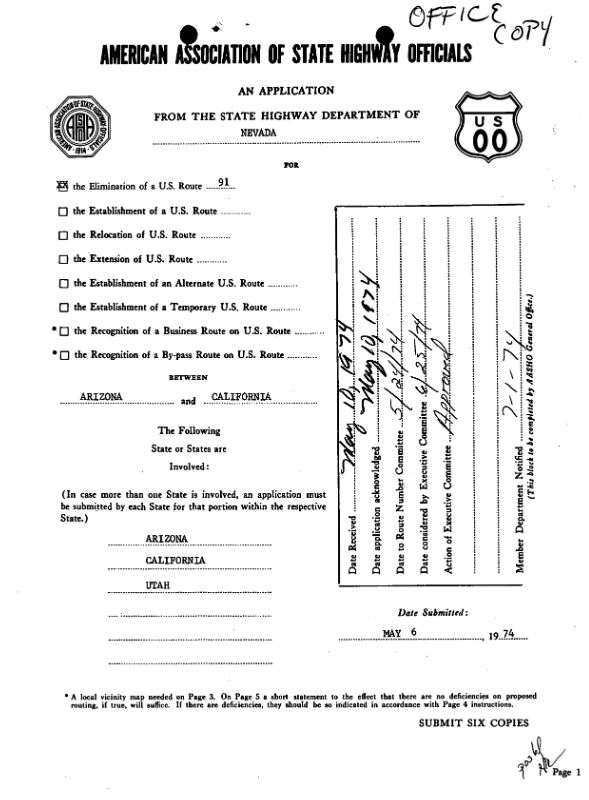
On February 15, 1956, the Nevada State Highway Engineer in a letter to AASHO advising that six copies of an application to establish US Route 66 Alternate to Las Vegas had been submitted.  The Nevada State Highway Engineer noted the State of California agreed to sign US Route 66 Alternate if approved and they were anticipated to submit their own like request to the AASHO Executive Committee.  


The actual submission to by the Nevada State Highway Engineer was made on February 27, 1956.  The proposed US Route 66 Alternate would have originated from mainline US Route 66 in Kingman Arizona and followed a multiplex of US Routes 466 and US Route 93 to Las Vegas, Nevada.  From Las Vegas, Nevada the proposed US Route 66 Alternate would have multiplexed US Routes 91 and US Route 91 back to mainline US Route 66 in Barstow, California.  The rationale for US Route 66 Alternate being established was that it was desired by the communities along the prospective highway to obtain access to an alternative alignment of US Route 66.  


Below the proposed routing of US Route 66 Alternate can be seen on a sketch map. 


Below a description of proposed US Route 66 Alternate can be observed.  Proposed US Route 66 Alternate is stated to be 259 miles long. 


The Arizona State Highway Engineer affirmed concurrent agreement with the US Route 66 Alternate proposal to the AASHO Executive Secretary in an undated Western Union telegram.  


The AASHO Executive Commitee considered US Route 66 Alternate during the June 27, 1956, meeting and ultimately denied the request.  The 1956 Federal Highway Aid Act would be signed into law on June 29, which brought the Interstate system into existence.  The corridor of US Route 91 through Nevada was selected as part of chargeable Interstate 15. 

The 1956 Gousha Highway Map of Nevada displays the alignments of the US Routes within downtown Las Vegas.  US Route 91 northbound is shown following Las Vegas Boulevard, 5th Street and north Main Street.  US Route 466 eastbound is shown following Las Vegas Boulevard, 5th Street and Fremont Street.  US Route 95 southbound is shown following Bonanza Road, Main Street and Fremont Street.  US Route 93 southbound is shown following Main Street and Fremont Street.  


The 1957 Nevada State Highway Department Map shows several changes to the US Route grid in downtown Las Vegas.  US Route 91 is shown with a split alignment following both 5th Street and Main Street (likely the Alternative route).  US Route 93 is shown being realigned fully onto 5th Street and off of Main Street.  US Route 95 is shown extended east of Main Street via Bonanza Road directly to 5th Street.  Fremont Street between Main Street and 5th Street is shown to no longer be state highway. 


The Las Vegas Strip is featured on the 1957 Nevada State Highway Department Map.  The "Las Vegas Strip" refers to the segment of Las Vegas Boulevard between Russell Road-Sahara Avenue south of the Las Vegas city limits in unincorporated Paradise and Enterprise. 


During 1959 5th Street in downtown Las Vegas and Main Street in North Las Vegas were renamed as part of Las Vegas Boulevard.  

Fremont Street facing east at the Golden Nugget is displayed on the 1963-1964 Nevada Department of Highways Map.  The then modern photo is contrasted by another photo from the 1920s.  


US Route 91 was approved by AASHO for truncation from Long Beach to Baker during 1963.  This was followed by US Route 466 being approved for truncation from Morro Bay to Baker during 1964.  These truncations would see US Route 91 and US Route 466 terminate on Baker Boulevard at the intersection with California State Route 127/Death Valley Road.  The truncations of US Route 91 and US Route 466 to Baker did not impact the existing routings in Nevada.  Interstate 15 north of Barstow to the Nevada state line would be completed in the California Division of Highways by 1965.

The 1965-1966 Nevada State Highway Department Map depicts Interstate 15 temporarily ending at Sahara Avenue at the Las Vegas city limit.  Temporary Interstate 15 is shown connecting to US Route 91/US Route 466 at Las Vegas Boulevard.  


Fremont Street at the Golden Nugget is featured on the 1965-1966 Nevada State Highway Map.


The 1968 Nevada State Highway Department map depicts Interstate 15 completed to Charleston Avenue in downtown Las Vegas and Lamb Boulevard north of the city.  


Las Vegas Boulevard facing towards the Dunes and Bonanza is featured on the 1968 Nevada State Highway Department Map.  


The states of Nevada, Arizona and California filled a joint request to AASHO to eliminate the remaining portion of US Route 466 on November 22, 1971.  The AASHO Executive Committee approved the deletion of US Route 466 on December 4, 1971.  The deletion of US Route 466 left US Route 93 as the only signed route over Hoover Dam.  


The 1972 Nevada State Highway Department Map no longer features US Route 466.  Interstate 15 is shown completed the vicinity of Bonanza Road in down Las Vegas along with a connecting stub to Las Vegas Boulevard.  North of downtown Interstate 15 is shown completed to Cheyanne Avenue.  West of downtown the proposed Crosstown Expressway is displayed as replacement for the existing alignment of US Route 95 along Bonanza Road and Tonopah Highway.   


AASHO approved a request submitted by the Nevada State Highway Department to removed US Route 91 from the state on June 25, 1974. The rationale for removing US Route 91 was that the highway was fully concurrent with the completed Interstate 15.  


The 1975 Nevada State Highway Department Map no longer depicts US Route 91.  US Route 93 is shown still following Las Vegas Boulevard from Fremont Street north to Interstate 15.  Interstate 15 is shown to be complete through downtown Las Vegas.  


AASHO approved a Nevada State Highway Department request to designate Interstate 515 between mainline Interstate 15 east to US Route 93/US Route 95 at Las Vegas Boulevard July 13, 1976.  The designation of Interstate 515 had been previously approved by the Federal Highway Administration on December 19, 1975.  Interstate 515 is shown to have a planned extension east to US Route 93/US Route 95 at Fremont Street near Desert Inn Road.  


As part of the 1976 Nevada State Highway Renumbering the remaining portions of Las Vegas Boulevard no longer part of the US Route System were designated as Nevada State Route 142.  US Route 93 on the 1978-1979 Nevada State Highway Department Map can be seen along Las Vegas Boulevard north of downtown.  Nevada State Route 142 can be seen on Las Vegas Boulevard south of downtown.  


Westbound Fremont Street in downtown Las Vegas appears on the 1978-1979 Nevada State Highway Department Map.  


The 1982 Nevada Department of Transportation Map depicts numerous changes to the US Route grid in Las Vegas.  US Route 93 is shown to be relocated onto Interstate 15 and Interstate 515 to Las Vegas Boulevard.  US Route 95 is shown to be relocated on the completed portions of Interstate 515 and the Crosstown Expressway west to Tonopah Highway.  What was once mainline US Route 95 on Tonopah Highway was signed as a Business Route without an AASHO application.   Las Vegas Boulevard is shown to have been renumbered as Nevada State Route 604.  During 1982 the Crosstown Expressway was renamed as "Oran K Gragson Expressway."  Oran K. Gragson was a former mayor of Las Vegas who had been elected in 1959 and advocated for freeway expansion in the area.  


On December 8, 1984, AASHTO approved a Nevada Department of Transportation request to extend Interstate 515 to Boulder City.  The planned extension of Interstate 515 is noted to be planned as the new alignment of US Route 95 and US Route 93.  The application notes planned extension of Interstate 515 was planned to be complete by 1992.  


The 1985-1986 Nevada of Transportation Map depicts Intestate 515 completed to Boulder Highway near Desert Inn Road.  US Route 95 and US Route 93 are shown to be relocated off Las Vegas Boulevard and Fremont Street to the new freeway.  US Route 95 and US Route 93 are shown transitioning onto Boulder Highway from the temporary freeway end.  


The 1987-1988 Nevada of Transportation Map depicts Interstate 515 completed to Tropicana Road.  US Route 95 and US Route 93 are still shown to depart onto Boulder Highway near Desert Inn Road as interim routing.  


The 1989-1990 Nevada Department of Transportation Map depicts Interstate 515 extended to Nevada State Route 146 at Lake Mead Drive.  US Route 95 and US Route 93 are shown to be realigned onto the end of the freeway and using Lake Mead Drive to reach Boulder Highway in Henderson.  


Interstate 515 was completed to the northern outskirts of Railroad Pass in 1994.  The 1995-1996 Nevada of Transportation Map depicts the completed Interstate 515 along with US Route 95 and US Route 93 following the freeway to Boulder Highway at Railroad Pass.  


The 1999 Nevada of Transportation Map depicts a portion of former Tonopah Highway (now Rancho Drive) converted to a freeway to Ann Road.  


The 2005-2006 Nevada Department of Transportation Map depicts the US Route 95 freeway extended north of Ann Road to Durango Drive.  


On May 12, 2014, the Nevada Department of Transportation submitted a request the American Association of State Highway and Transportation Officials to designate Interstate 11.  The request specified the Interstate 11 corridor was to include the planned Boulder City Bypass between the Arizona state line and Interstate 215.  Interstate 11 in the submission would fully overlap and multiplex US Route 93 south of Interstate 215 and replace approximately 5 miles of Interstate 515.  The submission noted the Boulder City Bypass was expected to be open during September 2018.  


The application by the Nevada Department of Transportation requesting an Interstate 11 designation along US Route 93 south of Interstate 215 to the Arizona state line was approved by the American Association of State Highway and Transportation Officials on May 29, 2014.  During May 2017 the American Association of State Highway and Transportation Officials approved an application for the surface segment of US Route 93 through Boulder City on Boulder City Highway to become the US Route 93 Business Route.  


Construction of the Boulder City Bypass would conclude in two Phases.  The Phase 1 corridor of the Boulder City Bypass was from Foothills Drive in Henderson south through Railroad Pass to the new Boulder City interchange.  The full Phase 1 segment of the Boulder City Bypass opened to traffic on May 23, 2018.  

Phase 2 of the Boulder City Bypass opened on August 9, 2018.  The Phase 2 corridor of the Boulder City Bypass included the entire freeway between the Boulder City interchange to Nevada State Route 172.  The Interstate 515 signage from Railroad Pass north to Interstate 215 was fully replaced with Interstate 11 signs by March 2019.  

During July 2022 the Las Vegas Review-Journal reported the Nevada Department of Transportation had selected a preferred routing for Interstate 11 through the Las Vegas Metropolitan Area.  The preferred corridor follows existing US Route 95 from the Interstate 215 interchange through the Spaghetti Bowl Interchange (Interstate 15) towards recently completed freeway to Nevada State Route 157.  The preferred routing of Interstate 11 would absorb the remaining mileage of Interstate 515 between Interstate 215 north to Interstate 15. 


As of the publishing date of this blog the Nevada Department of Transportation has not pursued making the extension of Interstate 11 official with the Federal Highway Administration or the American Association of State Highway and Transportation Officials.  The current Federal Highway Administration Interstate highway log depicts Interstate 11 as 22.6 miles.  To date, Arizona has not pursued any official designations for Interstate 11 south of the Mike O'Callaghan-Pat Tillman Bridge.  Presently Interstate 11 currently ends in the center of the Mike O'Callaghan-Pat Tillman Bridge at the Arizona state line.  


Part 2; a drive along Las Vegas Boulevard 

The below photo tour of Las Vegas Boulevard begins at the terminus of Nevada State Route 160 (Blue Diamond Road) at Las Vegas Boulevard in unincorporated Enterprise.  Las Vegas Boulevard continues north through Enterprise and crosses over Interstate 215 near Warm Springs Road.  Las Vegas Boulevard includes ramps to Interstate 15, Interstate 215 and Clark County Route 215 near Warm Springs Road.  


Las Vegas Boulevard enters unincorporated Paradise at Sunset Road.  


Northbound Las Vegas Boulevard approaches the "Welcome to fabulous Las Vegas, Nevada" sign approaching Russell Road.  


The "Welcome to fabulous Las Vegas, Nevada" sign located at 5100 South Las Vegas Boulevard. The sign was placed along Las Vegas Boulevard (then US Route 91 and US Route 466) approximately four miles south of the Las Vegas city limit by Clark County in 1959. Clark County paid $4,000 to install the sign which became a significant enough tourist attraction to be included on the Register of Historic Places in 2009.


Las Vegas Boulevard enters the 4.2 mile long "The Strip" at Russell Road.  The Strip was named an All-American Road in a June 15, 2000, press release from the U.S. Transportation Deputy Secretary.  The Pinball Hall of Fame can be found at the southeast corner of Las Vegas Boulevard and Russell Road.  


Mandalay Bay can be found at the northwest corner of Las Vegas Boulevard and Russell Road.  Much of The Strip can be observed from the Foundation Room located on the 63rd floor of Mandalay Bay.


Numerous pedestrian overpass structures can be found on Las Vegas Boulevard northbound approaching Flamingo Road (Nevada State Route 592).  The overpass structures are part of un-signed Nevada State Route 604 as they are maintained by the Nevada Department of Transportation. 


Las Vegas Boulevard continues north through The Strip amid the major casino resort.  The Strip terminates as Las Vegas Boulevard reaches Sahara Avenue (Nevada State Route 589) at the Las Vegas city limit.  Overhead The Stratosphere can be seen.  


Las Vegas Boulevard passes through "Gateway Arches" at The Stratosphere.  The Gateway Arches were illuminated for the first-time during August 2022.  


Downtown Las Vegas can be observed looking north from the top of The Stratosphere.  The split of Las Vegas Boulevard and Main Street is easy to observe from overhead.  As noted in Part 1, Main Street used to carry a late 1950s era US Route 91 Alternate whereas US Route 91 and US Route 466 stayed mostly on Las Vegas Boulevard.  


Below southbound Las Vegas Boulevard through Paradise and The Strip can be seen from the top of The Stratosphere (2016 era photo).  


Las Vegas Boulevard intersects Main Street immediately north of The Stratosphere.  


Traffic wishing to access downtown Las Vegas is directed to follow 4th Street away from Las Vegas Boulevard.  


Las Vegas Boulevard intersects Nevada State Route 159 at Charleston Avenue.  


Las Vegas Boulevard intersects Fremont Street in downtown Las Vegas.  US Route 91 would have once continued north on Las Vegas Boulevard whereas US Route 466 turned east on Fremont Street.  The early configurations of US Route 95 and US Route 93 would have crossed Las Vegas Boulevard via Fremont Street.  


Las Vegas Boulevard north of Fremont Street intersects Interstate 515, US Route 95 and US Route 95.  As of the release of this blog no surface-level Interstate 11 were observed in downtown Las Vegas.  


Las Vegas Boulevard north of Interstate 515 intersects the late 1950s alignment of US Route 95 at Bonanza Road.  


The Neon Museum can be found 770 North Las Vegas Boulevard.  


The Neon Museum is a boneyard of numerous vintage neon signs which were once in service along Las Vegas Boulevard and Fremont Street. The Neon Museum was established during 1996 and opened to visitors during 2012.


Part 3; a walk and drive along Fremont Street

Fremont Street west of Las Vegas Boulevard once carried US Route 95 and US Route 93.  During 1995 the corridor was converted into a pedestrian mall (Fremont Street Experience) and has since been covered by an illuminated overhead awning. 


Pictured below is a view on north Main Street from the western end of Fremont Street.  US Route 95 and US Route 93 would have once made a right-hand turn from Fremont Street onto Main Street at this location.


Fremont Street east of Las Vegas Boulevard is still open to traffic and was once used by US Route 95, US Route 93 and US Route 466 to reach Boulder Highway.  Pictured below is a series of photos along Fremont Street from Las Vegas Boulevard to Charleston Avenue.  


Comments

Popular posts from this blog

Paper Highways: The Unbuilt New Orleans Bypass (Proposed I-410)

  There are many examples around the United States of proposed freeway corridors in urban areas that never saw the light of day for one reason or another. They all fall somewhere in between the little-known and the infamous and from the mundane to the spectacular. One of the more obscure and interesting examples of such a project is the short-lived idea to construct a southern beltway for the New Orleans metropolitan area in the 1960s and 70s. Greater New Orleans and its surrounding area grew rapidly in the years after World War II, as suburban sprawl encroached on the historically rural downriver parishes around the city. In response to the development of the region’s Westbank and the emergence of communities in St. Charles and St. John the Baptist Parishes as viable suburban communities during this period, regional planners began to consider concepts for new infrastructure projects to serve this growing population.  The idea for a circular freeway around the southern perimeter of t

Hernando de Soto Bridge (Memphis, TN)

The newest of the bridges that span the lower Mississippi River at Memphis, the Hernando de Soto Bridge was completed in 1973 and carries Interstate 40 between downtown Memphis and West Memphis, AR. The bridge’s signature M-shaped superstructure makes it an instantly recognizable landmark in the city and one of the most visually unique bridges on the Mississippi River. As early as 1953, Memphis city planners recommended the construction of a second highway bridge across the Mississippi River to connect the city with West Memphis, AR. The Memphis & Arkansas Bridge had been completed only four years earlier a couple miles downriver from downtown, however it was expected that long-term growth in the metro area would warrant the construction of an additional bridge, the fourth crossing of the Mississippi River to be built at Memphis, in the not-too-distant future. Unlike the previous three Mississippi River bridges to be built the city, the location chosen for this bridge was about two

Huey P. Long Bridge (New Orleans, LA)

Located on the lower Mississippi River a few miles west of New Orleans, the Huey P. Long Bridge is an enormous steel truss bridge that carries both road and rail traffic on an old-time structure that is a fascinating example of a bridge that has evolved in recent years to meet the traffic and safety demands of modern times. While officially located in suburban Jefferson Parish near the unincorporated community of Bridge City, this bridge’s location is most often associated with New Orleans, given that it’s the largest and most recognizable incorporated population center in the nearby vicinity. For this reason, this blog article considers the bridge’s location to be in New Orleans, even though this isn’t 100% geographically correct. Completed in 1935 as the first bridge across the Mississippi River in Louisiana and the first to be built in the New Orleans area, this bridge is one of two bridges on the Mississippi named for Huey P. Long, a Louisiana politician who served as the 40th Gove