
Interstate 40 Spur in Barstow


Interstate 40 Spur is 0.794-mile hidden State Highway which exists in the city of Barstow, California. Interstate 40 Spur originates at National Trails Highway and follows Main Street west to the vicinity of Coolwater Lane. Interstate 40 Spur is a former segment of US Route 66 which was bypassed during July 1961. The purpose of Interstate 40 Spur is to permit movement from westbound Interstate 40 to northbound Interstate 15.


The history of Interstate 40 Spur

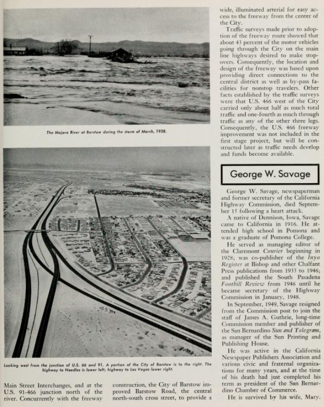
The September/October 1961 California Highways & Public Works announced the opening of the Barstow Bypass.  The Barstow Bypass was primarily a component of Interstate 15 which opened on July 5, 1961.  The Barstow Bypass included the exit ramp to Interstate 40 and the first stub of the freeway eastward towards Needles.  The mainlines of US Route 66 and US Route 91 were relocated onto the new freeway bypass whereas the previous surface routings were retained as a Business Routes.  Main Street (former US Route 66) between Interstate 40 and Interstate 15 was retained as a spur of Legislative Route Number 58 (LRN 58).  This section of State Highway was necessary to retain to due to the Interstate 15/Interstate 40 interchange not permitting traffic to transition from westbound Interstate 40-to-northbound Interstate 15 and southbound Interstate 15-to-eastbound Interstate 40.  


The US Route 66 Business Route along Main Street in Barstow had been approved by the American Association of State Highway Officials (AASHO) during their November 1960 Meeting.  The application was made by the Division of Highways in advance of the Barstow Bypass opening.  


US Route 66 was approved to be truncated from Santa Monica to US Route 95 in Needles by the AASHO on November 14, 1963.  Signage of US Route 66 would not be truncated from Pasadena to US Route 95 until Interstate 40 was completed through the Bristol Mountains in 1972.  The US Route 66 Business Route on Main Street in Barstow would be swapped without application to Interstate 15 Business.  


As part of the wider 1964 State Highway Renumbering the Legislative Route Numbers were dropped.  The spur facility of LRN 58 on Main Street between Interstate 40-Interstate 15 was re-designated as Interstate 40 Spur.  Interstate 40 Spur remains minimally signed as Interstate 15 Business.  Interstate 40 Spur can be seen below as presently configured in the Caltrans Postmile Tool.  


Note, Caltrans recognizes all categories of their highway inventory as "State Routes."  To that end Interstate 40S is not considered part of the Interstate System by the Federal Highway Administration and does not appear in their mileage calculations for Interstate 40.  

Comments

Popular posts from this blog

Did Caltrans just kill the G26 cutout US Route shields?

The US Route System was formally created by the American Association of State Highway Officials during November 1926.  Through the history of the system the only state to which has elected to maintain cutout US Route shields has been California.  The G26 series cutout US Route shields have become a favorite in the road enthusiast hobby and are generally considered to be much more visually pleasing than the standard Federal Highway Administration variant.  However, the G26 shield series appears to have been killed off on January 18, 2026, when Caltrans updated their Manual of Uniform Traffic Control Devices.  This blog will examine the history of the US Route shield specifications in California and what is happening with the 2026 changes.  The blog cover photo is facing towards the terminus of California State Route 136 and at a G26-2 specification US Route 395 shield.  In the background Mount Whitney can be seen in the Sierra Nevada range.   ...

May 2023 Ontario Trip (Part 3 of 3)

  Over the years, I have made plenty of trips to Ontario, crisscrossing the southern, central and eastern parts of the province. Living in Upstate New York, it's pretty easy to visit our neighbor to the north, or is that our neighbor to the west? Ottawa is one of my favorite cities to visit anywhere in the world, plus I've discovered the charm of Kingston, the waterfalls of Hamilton (which is on the same Niagara Escarpment that brings us Niagara Falls), the sheer beauty of the Bruce Peninsula, and more. But I hadn't explored much of Cottage Country. So I decided to change that, and what better time to go than over Memorial Day weekend, when the daylight is long and I have an extra day to explore. On the third and final day of my trip, I started in Huntsville and made my way through Muskoka District and Haliburton County, passing by many lakes along the way. I stopped in towns such as Dorset, Haliburton and Bancroft before making a beeline down to Belleville and then over th...

Ghost Town Tuesday; Nichols, FL

A couple years ago I spent a lot of spare time exploring phosphate mining ghost towns in the Bone Valley of Polk County, Florida.  One ghost town in particular called Nichols on Polk County Route 676 west of Mulberry caught my eye due to a relative lack of documentation on ghosttowns.com. Nichols was created in 1905 during the early phosphate mining boom in the Bone Valley region.  For the time Nichols was unusual since it had company housing in the Nichols Mine site and private residences outside the gate.  Nichols is only about two miles west of Mulberry which probably made it a somewhat reasonable commute even by the wonky standards of the early 20th Century.  Most of the Bone Valley region was relatively remote which made commuting or homesteading impractical which is why there are so many ghost towns in the area.  The company housing section of Nichols was phased out and abandoned by 1950. The Nichols town site is largely abandoned and could "possibl...