
The southern terminus of US Route 611 at Philadelphia City Hall


US Route 611 was one of the original US Routes in Pennsylvania which were defined when the US Route System was created on November 11, 1926.  The southern terminus of US Route 611 was always located in the city of Philadelphia.  US Route 611 likely from the time it was signed probably always had a southern terminus at Philadelphia City Hall via northern Broad Street.  US Route 611 was deleted by the American Association of State Highway Officials during 1972 and was replaced with Pennsylvania Route 611.  Pictured below as the blog cover is a view southward on Broad Street to what was the southern terminus of US Route 611 at Philadelphia City Hall.  Below US Route 611 can be seen terminating at Philadelphia City Hall via north Broad Street on the 1949 United States Geological Survey map of Philadelphia. 


Part 1; the history of the southern terminus of US Route 611

The US Route System was created by the America Association of State Highway Officials (AASHO) on November 11, 1926.  US Route 611 appears as an intra-state US Route ending in Philadelphia and Scranton.


The initial route description of US Route 611 did not describe where the highway ended in Philadelphia.  According to usends.com the signage US Routes in Pennsylvania probably did not begin until 1928 and not within Philadelphia until 1931.  Indeed, even commercial maps such as the 1927 Rand McNally Map of Philadelphia omit exact alignments of the US Routes within the city.  The 1927 Rand McNally Map of Philadelphia shows US Route 611 concurrent with Pennsylvania Route 2 on the Lackawanna Trail to the northern city limits.  Pennsylvania Route 2 would be decommissioned during 1928.  


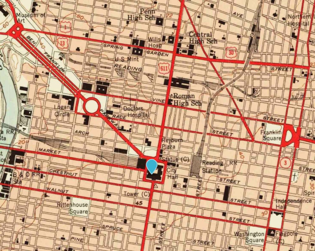
Ultimately Philadelphia City Hall and Penn Square were located as the southern terminus of US Route 611.  The terminus of US Route 611 being located at Philadelphia City Hall was logical due to Penn Square acting as a rotary where it intersected Pennsylvania Route 3.  US Route 611 can be seen terminating at Philadelphia City Hall and Penn Square on the 1949 United States Geological Survey Map of Philadelphia. 


By 1950 Pennsylvania Route 291 was extended to Philadelphia City Hall via south Broad Street to a new terminus at US Route 611.  US Route 611 and Pennsylvania Route 291 can be seen terminating at each other via both ends of Broad Street at Philadelphia City Hall on the 1956 Gousha Highway Map of Philadelphia.  


US Route 611 may have been for an unknown amount of time been co-signed with a mutual southern terminus with US Route 309 at Philadelphia City Hall.  US Route 309 can be seen terminating at Philadelphia City Hall via north Broad Street along US Route 611 on a 1967 request by the State Highway of Pennsylvania to eliminate the former.  US Route 309 was approved to be deleted by the AASHO on October 14, 1967.  


The 1967 United States Geological Survey Map of Philadelphia depicts only US Route 611 ending at Philadelphia City Hall via north Broad Street.


US Route 611 was deleted during the December 1971 AASHO Meetings.  The justification for the elimination of US Route 611 was that it was entirely contained to Pennsylvania.  US Route 611 by the time it was decommissioned may have been truncated to a realigned US Route 30 at Vine Street five blocks north of Philadelphia City Hall. 


Following US Route 611 being decommissioned it was replaced by Pennsylvania Route 611.  Pennsylvania Route 611 initially retained a southern terminus at Philadelphia City Hall suggesting US Route 611 was never truncated to Vine Street.  During 1989 Pennsylvania Route 611 was extended via south Broad Street to Interstate 95 and the entrance to the Philadelphia Naval Shipyard. 


Part 2; exploring the southern terminus of US Route 611 at Philadelphia City Hall

The below photo depicts a westward view on John F. Kennedy Boulevard at Penn Square facing where US Route 611 once began at north Broad Street.  


Below is a view south on Broad Street towards Philadelphia City Hall and what was the terminus of US Route 611.  


Philadelphia City Hall itself is a notable structure and would make for something of a grand terminus for any highway.  Philadelphia City Hall was under construction from 1871 through 1901.  The tower atop Philadelphia City Hall was completed during 1894 which brough the structure to a height of 548 feet.  Philadelphia City Hall would be the tallest inhabitable building in the world until 1908.  Philadelphia City Hall features a Second Empire architectural design and can be found at the address 1 Penn Square.  


Part 3; the current terminus of Pennsylvania Route 611 at the Philadelphia Naval Shipyard

Below the current northbound beginning of Pennsylvania Route 611 can be seen immediately beyond the gate to the Philadelphia Naval Shipyard on Broad Street approaching Interstate 95.  The below photos were taken during Day 1 of the 2022 Philadelphia, PA National Road Meet.  The Philadelphia Naval Shipyard was in use as an active military base from 1801-1995.  The Philadelphia Naval Shipyard is largely used today as an industrial port where over 15,000 workers are employed.  


Comments

Popular posts from this blog

North Carolina Continues to Move Forward with Rail

2023 and the first half of 2024 have seen continued growth in North Carolina's passenger rail system.  From increased daily trains from Raleigh to Charlotte, federal funds for studying additional corridors, and receiving a historic grant to begin the construction of high-speed rail between Raleigh and Richmond, the last 18 months have been a flurry of activity at NCDOT's Rail Division.  And that's just the tip of the iceberg. As ridership and routes increase - the engine of North Carolina passenger rail trains will become a more common sight. (Adam Prince) Increased Passenger Train Service: On July 10, 2023, a fourth Piedmont round-trip rail service between Raleigh and Charlotte commenced.  The four Piedmont trains plus the daily Carolinian (to Washington, DC, and New York) bring the total of trains serving the two cities daily to five. The current daily Piedmont and Carolinian schedule between Charlotte and Raleigh (NCDOT) The result was over 641,000 passengers utilized pa

US Route 101 in Benbow, Garberville and Redway

The communities of Benbow, Garberville and Redway can all be found along US Route 101 within southern Humboldt County.  The former surface alignment of US Route 101 in Garberville and Redway once crossed the Garberville Bluffs along what is now Redwood Drive via a corridor constructed as part of the Redwood Highway during the 1910s.  US Route 101 through Benbow, Garberville and Redway was modernized by 1935.  US Route 101 would eventually be upgraded to freeway standards in Benbow, Garberville and Redway by extension of the Redwood Freeway during 1966-68.  As the cover photo the original grade of US Route 101 and the Redwood Highway can be seen at the Garberville Bluffs during 1934.  US Route 101 can be seen in the communities of Benbow, Garberville and Redway on the 1935 Division of Highways Map of Humboldt County .   The history of US Route 101 in Benbow, Garberville and Redway Benbow, Garberville and Redway lie on the banks of the South Fork Eel River of southern Humboldt County.  D

The Midway Palm and Pine of US Route 99

Along modern day California State Route 99 south of Avenue 11 just outside the City limits of Madera one can find the Midway Palm and Pine in the center median of the freeway.  The Midway Palm and Pine denotes the halfway point between the Mexican Border and Oregon State Line on what was US Route 99.  The Midway Palm is intended to represent Southern California whereas the Midway Pine is intended to represent Northern California.  Pictured above the Midway Palm and Pine can be seen from the northbound lanes of the California State Route 99 Freeway.   This blog is part of the larger Gribblenation US Route 99 Page.  For more information pertaining to the other various segments of US Route 99 and it's three-digit child routes check out the link the below. Gribblenation US Route 99 Page The history of the Midway Palm and Pine The true timeframe for when the Midway Palm and Pine (originally a Deadora Cedar Tree) were planted is unknown.  In fact, the origin of the Midway Palm and Pine w