

Author's Note; Gribblenation's 2,000th published blog
This blog serves as the 2,000th published entry on the Gribblenation blog site. Ironically the the 2,000th blog entry closely aligns with the 20th anniversary of Gribblenation. Adam and Doug recently discussed the history of Gribblenation on the Gribblenation 20th Anniversary Podcast:
For my own part I (Tom) have been part of Gribblenation since late 2016, it has been an honor to be part of one of the longest lived highway pages on the web. I feel as though I speak for everyone at Gribblenation (Adam, Doug and Dan) in that we all truly enjoy what we do and I hope that is conveyed in our writings. Hopefully our readers have enjoyed being along for the ride over the years. I thought the Mosquito Road Bridge would be a perfect topic for our 2,000th blog given it exemplifies our mission statement at Gribblenation; "every road has a story."
The Mosquito Road Bridge ("Mosquito Bridge") as currently constructed carries a road deck built in 1939. According to bridgehunter.com the Mosquito Bridge is 245.1 feet in length and carries a 8.9 foot wide road deck. As noted in the introduction the Mosquito Bridge is a wood suspension design.
According to El Dorado County's public website on the Mosquito Road Bridge Construction Project the County Board of Supervisors ordered construction of Mosquito Road in 1859. Mosquito Road was intended to plot a direct road connection between Placerville northeast to the community of Mosquito. By 1867 the "Swinging Bridge" over the South Fork American River was constructed. According to sierranevadageotourism.org the Swinging Bridge of Mosquito Road was referred to in a 1883 book titled "El Dorado County History." The excerpt cited by sierranevadageotourism.org reads as follows pertaining to the Swinging Bridge of Mosquito Road:
"According to the El Dorado County History of 1883 by Paolo Sioli, 'Mosquito is connected to Placerville by a good wagon-road and a suspension bridge across the South Fork of the American River, a trail is running in the direction of Kelsey, the township center... The original bridge was constructed in 1867, and according to Orval Beckett, as quoted in the booklet, Mosquito Memories, 'This original bridge had no banisters on the sides. It was a suspension cable with No.14 telephone wires strung between the supports. When you drove onto the bridge, it would 'swing and sway' much like we have seen in the movies. When one end went down the other went up. Imagine the thrill!'"
Mosquito Road between Placerville and Mosquito can be seen on the 1887 USGS Map of the Placerville Quadrangle. The Swinging Bridge can be observed crossing the South Fork American River.

The Swinging Bridge of Mosquito Road would remain in service well into the 20th Century and would service early automotive travel between Placerville and Mosquito. Indeed Mosquito Road and the Swinging Bridge can be seen on the 1935 Division of Highways Map of El Dorado County.
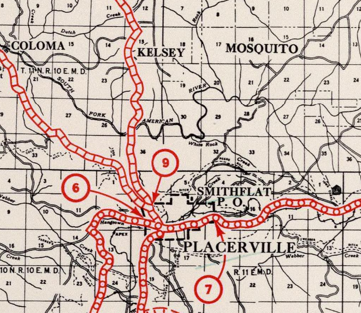
According to El Dorado County's page on the Mosquito Road Bridge Construction Project the Swinging Bridge road deck was replaced in 1939 and the structure retained most of the 1867 foundations. Since 1939 reconstruction the structure has come be known as the Mosquito Road Bridge. The Mosquito Bridge is due to be replaced given it is poorly adapted to modern traffic. The Mosquito Bridge is cited on the Mosquito Road Bridge Construction Project page as having a sufficiency rating of 12.5 out of 100.
A June 2017 Environmental Impact Study does not explicitly state the fate of the current Mosquito Road Bridge. The Environmental Impact Study does note in Chapter 2 Section 9 several public concerns which seem to favor retaining the current Mosquito Bridge given it's historic status and potential pedestrian use.
A December 10th, 2019 El Dorado County Power Point presentation provides a overview history of the Mosquito Road Bridge Construction Project. The selection of a new Mosquito Road Bridge design is stated to have taken place during June of 2019.

The design sketch of the new Mosquito Road Bridge along with a graphic which shows where it will be located relative to the current span are displayed. The new Mosquito Road Bridge will shorten Mosquito Road by slightly over a mile.


Several historic photos of the Mosquito Road Bridge are shown in the El Dorado County Power Point presentation.


Construction of the Mosquito Road Bridge replacement has been pushed to Spring of 2022.

Part 2; a drive over the Mosquito Road Bridge
Mosquito Road begins at Placerville diverging northward from Main Street (former US Route 50 and the South Lincoln Highway) underneath modern US Route 50.

Mosquito Road continues northeast out of the City Limits of Placerville as a convention two-lane highway. At Union Ridge Road the alignment of Mosquito Road makes a left hand turn towards the South Fork American River.


Traffic on Mosquito Road is advised that the Mosquito Bridge is ahead. The weight limit of the Mosquito Bridge is set at 5 tons along with a 8 foot width and 25 foot length advisory.

The Mosquito Bridge is cited to be three miles ahead on Mosquito Road just beyond Union Ridge Road.

Mosquito Road continues northeast as a two-lane road before dropping to a single lane.


Mosquito Road winds northeast towards the South Fork American River where traffic is given a second 5 ton weight advisory a half mile from the Mosquito Bridge.


Approaching the final descent to the Mosquito Bridge traffic on Mosquito Road is advised of a 15% downhill grade.

Mosquito Road swings through a sharp switchback towards the Mosquito Bridge. Northbound traffic is advised to yield to uphill traffic.


Mosquito Road descends to the South Fork American River and Mosquito Bridge. Northbound traffic is advised to yield to oncoming traffic.


Mosquito Road northbound and crosses the South Fork American River via the Mosquito Bridge.


Mosquito Road northbound climbs away from the South Fork American River and Mosquito Bridge via four steep/sharp switchbacks.


Turning southward Mosquito Road descends the four switchbacks on the north bank of the South Fork American River to the Mosquito Bridge. Traffic headed southbound is advised to yield to uphill traffic.


Southbound Mosquito Road crosses the South Fork American River via the Mosquito Bridge.


Comments