
Meadville's PennDOT Road Sign Scultpture Garden

The PennDOT Road Sign Scultpture Garden in Meadville, Pennsylvania is a joint public art project between PennDOT and Allegheny College that began in 2002 to give a distinct look to Meadville's gateway from the west. Using recycled signs and tires, it is truly one of a kind. The sign garden is located at a Meadville PennDOT residency at US 6, US 19 and US 322's junction with PA 102, east of Interstate 79 and west of downtown Meadville. I've had a few occasions to check out the sign sculpture garden myself and I fully endorse recycling signs in this manner. It's a nice little stop to stretch your legs. I took the following pictures in September 2007.

One of the first parts of the project, and what you'll notice first if you are coming from the west, is the Signs and Flowers part of the art exhibit. This is also next to where you would likely park your car if you wanted to stop and take a look around.


It's a flower garden... of signs.

Blooming sign flower.

Blooming sign flower.

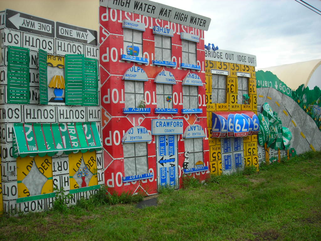
There's also a wall of signs called the Read Between the Signs mural that is alongside the highway as well which is worth checking out. 1200 feet of signs in all from what I'm told.

Gives you a little perspective on how tall the signs are.

And how long the sign wall goes on for.

Up, up and away!

Ferris Wheel.

Do 6!

Signs in the weeds.

Signs about town.


Some other articles about the sign garden...
http://sites.allegheny.edu/news/2014/09/24/kaleidoscope-public-art-abounds-in-meadville/
http://uncoveringpa.com/penndot-road-sign-sculpture-garden-meadville
https://pittsburghorbit.com/2015/08/26/the-meadville-penndot-road-sign-sculptures-part-2-the-flower-garden/

Also, see my complete set of photos from the sign garden on Flickr.

Comments

penndot hours said…
The penndot hours oversees highway programs and transportation issues in Pennsylvania's Common Wealth. Additionally, it deals with issues related to rural transportation, railroads, ports, and waterways. Most of Penndot's employees are involved in restoration, maintenance, and expansion of the state highway system. In addition, it has started focusing on intermodal transportation, which is very effective eat way to increase both public and commercial transportation. The department is also responsible for registering motor vehicles and issuing driver's licenses.

Popular posts from this blog

The 1915-era Teilman Bridge (the only known Concrete Pony Truss Bridge in California)

The Teilman Bridge is a semi-abandoned structure over Fresno Slough west of Burrell siding near the intersection of Elkhorn Avenue and Elkhorn Grade.  This structure is the only known Concrete Pony Truss Bridge constructed in California and was designed by Ingvart Teilman.  Teilman's Bridge would open in late 1915 when the Elkhorn Grade was the primary road between Fresno and Coalinga.  The structure would be replaced in 1991 but was left standing as it carries pipelines over Fresno Slough.  Part 1; the history of the Teilman Bridge In the early Twentieth Century the most direct highway between Fresno and Coalinga followed the Elkhorn Grade.  The Elkhorn Grade began at Fresno Slough a short distance west of Burrell siding.  From Fresno Slough the Elkhorn Grade followed a generally southwestern course through San Joaquin Valley into the Kettleman Hills towards Coalinga.   The Elkhorn Grade can be seen on the  1914 C.F. Weber map of Fresno Coun...

The Dummy Lights of New York

  A relic of the early days of motoring, dummy lights were traffic lights  that  were  placed  in the middle of a street intersection. In those early days, traffic shuffled through busy intersections with the help of a police officer who stood on top of a pedestal. As technology improved and electric traffic signals became commonplace, they were also  originally  positioned on a platform at the center of the intersection. Those traffic signals became known as  " dummy lights "  and were common until  traffic lights were moved  onto wires and poles that crossed above the intersection.  In New York State, only a handful of these dummy lights exist. The dummy lights  are found  in the Hudson Valley towns of Beacon and Croton-on-Hudson, plus there is an ongoing tug of war in Canajoharie in the Mohawk Valley, where their dummy light has been knocked down and replaced a few times. The dummy light in Canajoharie is currently...

Prunedale Road (Monterey County)

Prunedale Road is a short 2.6-mile-long frontage corridor of US Route 101 in the namesake Monterey County community of Prunedale.  Prior to 1932 US Route 101 bypassed Prunedale in favor of the San Juan Grade to the east.  Prunedale Road along with nearby Moro Road served as an alternative connecting highway between Salinas and San Juan Bautista.  Following the realignment of US Route 101 onto the Prunedale Cutoff the former through route along Prunedale Road would be rendered as a western frontage.   Part 1; the history of Prunedale Road Prunedale Road is located in and is named after the Monterey County community of Prunedale.  Said community was founded near the junction of San Migeul Canyon, Langley Canyon and Echo Valley.  Watsonville settler Charles Langley (namesake of Langley Canyon) was one of the prominent early community settlers.  The Prunedale Post Office would open for the first time in 1894 but would close by 1908.  Early agricu...