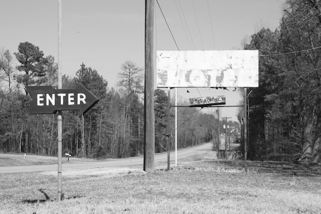
About 15 years ago, I was on an explore trip with my friend Joe. We drove up US 1 in Virginia, turned east on VA 40, and then headed south back home to North Carolina via US 301. Just before the town of McKenney, Virginia, was an old motel - complete with leftover signage to where it looked like it hadn't been long abandoned.
 |
| A fire in late 2009 or 2010 - destroyed a wing of rooms at the former Wilmurt Motel. The property was condemned as a result. Also in the photo, the Economy Inn branding from the motel's later days. |
There was what appeared to have been a recent fire, which led to condemnation of the entire site. We grabbed some great photos - and for the most part, I had thought it was long torn down by now.
 |
| This great neon restaurant sign stood tall long after Wilmurt's restaurant closed. As of this writing, I do not know when the restaurant part of the operation closed. |
However, when I recently went through the trip's photo album, I looked at Google Streetview and found the motel still stands. From the looks of things, the damaged buildings were repaired at one point. However, it appears the old motor lodge and restaurant remain abandoned.
Initially, I had no plans to have a separate entry or feature on Wilmurt's Motel. However, seeing that the buildings are still standing, I figured, why not try to have a more permanent and searchable internet presence than a Facebook post.
 |
| Wing of motor lodge rooms that were added in the 1950s. |
Wilmurt's Motel dates to the 1930s. It originally had guest cabins, a gas station, and a restaurant. The establishment grew in the 1950s as the cabins were converted to a more conventional motor court style. Wilmurt's was now home to 54 rooms for US 1 travelers. A new brick facade was built in front of the original two-story 'lunch room' and showers.
Wilmurt's also added a pool, and the Esso station would eventually close. At some point, Wilmurt's would become rebranded as the 'Economy Inn;' however, nearly all of the original signage for Wilmurt's remained in place.
 |
| Inside on of the abandoned motel rooms. Unlike many abandoned properties, the rooms were still in good shape. |
When Joe and I explored here in February 2010, it did appear that the motel had not been closed long. There were still handwritten signs regarding checkout times and other motel rules. Also, most of the motel rooms had not been trashed as you would expect at a site that would have been abandoned longer.
 |
| A lot of old travel stickers on the lobby window at Wilmurt's. The latest date on the stickers is 2005 - the motel was still in operation then. |
There were even some vintage business stickers on the front window. For example, Wilmurt's Motel was a 1979 member of the Virginia Travel Council.
 |
| Though at the end of its life it was an 'Economy Inn' - nearly all of the old Wilmurt's Motel signing remained. |
What is the future of Wilmurt's Motel? What is more of its past? From my research, I found old postcards dating from 1968 or earlier - that is a long gap between 1968 and 2010. If you have any old stories or information about Wilmurt's Motel, leave a comment below or send me an e-mail.
All photos taken by post author - February 26, 2011 - unless otherwise noted.
Site Navigation:
Sources & Links:
- Wilmurt Motel & Restaurant - McKenney, Virginia ---The Cardboard America Motel Archive
- Wilmurt's Motel ---Dead Motels USA
How To Get There:


Comments