Interstate 10 has a short spur along the San Bernardino Freeway in downtown Los Angeles. The Spur begins at the Santa Ana Freeway (US Route 101) and extends east to Interstate 5 where it merges into mainline Interstate 10. This portion of the San Bernardino Freeway is one of the oldest freeway segments in Los Angeles having been part of US Routes 60, 70 and 99 when it was part of the corridor of the Ramona Expressway. The current corridor of the Interstate 10 Spur was assigned as Chargeable Corridor H following the passage of the 1956 Federal Highway Aid Act. Interstate 110 was a short-lived designation which comprised the segment San Bernardino Freeway from US Route 101 to Interstate 5 between 1964-1968. The original Interstate 110 was dropped as a Chargeable Corridor during 1965 and consolidated as a spur of Interstate 10 during 1968.
The original Interstate 110 can be seen as the blog cover photo as it was featured on the 1964 Division of Highways Map. Below the entire 0.65-mile length of the Interstate 10 Spur can be seen as it is depicted in the Caltrans Postmile Tool.
Part 1; the history of Interstate 10 Spur in Los Angeles
As originally envisioned in the early drafts of US Route System what became US Route 66 in California was intended to be US Route 60. The designation of the Chicago-Los Angeles corridor was intended to carry a X0 route number given it was to denote a major east/west US Route. Ultimately the State of Kentucky petitioned to have a X0 US Route and the Chicago-Los Angeles corridor became US Route 66 in the finalized US Route System created by the American Association of State Highway Officials (AASHO) during November 1926.
US Route 60 would rapidly be extended after the US Route System was created and would come into play in California during the early 1930s. A letter from the AASHO Executive Secretary to the California State Highway Engineer dated Marth 30, 1931 noted that US Route 60 had been tentatively approved to be extended to California during the AASHO Executive Committee on May 26, 1930. The approval of US Route 60 being extended to California carried the stipulation that the Colorado River Bridge in Blythe be purchased by the California Division of Highways and Arizona State Road Department. The letter noted California and Arizona had taken steps through their respective legislatures to purchase the Colorado River Bridge and the terminus of US Route 60 to be at an undisclosed location in Los Angeles.


A letter from the California State Highway Engineer to the AASHO Executive Secretary on April 13, 1931, noted legislation to purchase the Colorado River Bridge had been passed in California. The purchase of the Colorado River Bridge effectively made the extension of US Route 60 into California active.
The California State Highway Engineer submitted a recommended routing of US Route 60 to the AASHO Executive Secretary on September 8, 1931. The route description of US Route 60 show as ending in Los Angeles by way of Pomona at an undisclosed terminus.
The AASHO Executive Secretary advised the California State Highway Engineer in a letter dated June 22, 1932, that the way points of US Route 60 in California were approved by the AASHO Executive Committee. US Route 60 was to follow
Legislative Route Number 26 (LRN 26) from Pomona to the Los Angeles city limit to an undisclosed terminus in the city. LRN 26 had been extended by the State Legislature during 1931 from Colton to Los Angeles via Pomona. Prior to 1933 the Division of Highways could not maintain highway mileage within incorporated cities.

State Maintenance of LRN 26 and US Route 60 was extended to downtown Los Angeles to Aliso Street during 1933 upon the California State Legislature permitting the Division of Highways to maintain mileage within incorporated cities. A series of September 1934, letters by the California State Highway Engineer to the American Association of State Highway Officials (AASHO) Executive Secretary noted a recommendation to move US Route 99 from Los Angeles to Redlands via LRN 26 through Pomona and Colton. The California State Highway Engineer noted traffic on US Route 99 would be better served traversing downtown Los Angeles and utilizing US Route 60/LRN 26 directly to reach Redlands. Notably the alignment the sketch map provided by the California State Highway Engineer shows existing US Route 99 following San Fernando Road to US Route 66 at Arroyo Seco Avenue and a multiplex on US 66/LRN 165 via Figueroa Street to Colorado Boulevard.
The same exchange of letters also notes US Route 70 had been extended into California with an endpoint following US Route 60/LRN 26 into downtown Los Angeles. The routing definition of US Route 70 indicated it would multiplex US Route 99/US Route 60 east from downtown Los Angeles to Pomona and onwards to US Route 60 east to Beaumont.
The 1
934 Division of Highways City Insert implies US Route 60/LRN 26 followed an interim alignment from downtown Los Angeles eastward following Macy Street, Mission Street, Alhambra Avenue and Valley Boulevard towards Pomona. The planned Ramona Expressway can be seen as a dotted line connecting Macy Street directly to Garvey Avenue.

The
March 1934 California Highways & Public Works features the upcoming Los Angeles-Pomona Arterial which was to follow what would become Ramona Boulevard. The Los Angeles-Pomona Arterial is described as being completed from Mountain View Road east to the city limits of Pomona. The Los Angeles-Pomona Arterial is described as having a western extent at Aliso Street and Mission Street in downtown Los Angeles.
The 1935 Division of Highways Map of downtown Los Angeles displays US Route 99/US Route 60 (solid red line) following an interim alignment of LRN 26 east via Macy Street, Brooklyn Avenue and Mednik Avenue towards the completed segment of the Ramona Boulevard. US Route 99/US Route 60 on LRN 26 are shown transitioning from the Ramona Expressway onto Garvey Avenue in Monterey Park.

The
February 1935 California Highways & Public Works announced the nearing completion of Ramona Boulevard. Construction of Ramona Boulevard is cited as having begun in 1932 and is stated to have six miles containing no grade crossings. Ramona Boulevard is stated to tie in with Aliso Street/Mission Street in Los Angeles east to Garvey Avenue.
The
June 1935 California Highways & Public Works announced the completion of Ramona Boulevard which served as the new alignment of US Route 99/US Route 60/US Route 70 LRN 26 from downtown Los Angeles to Monterey Park. Ramona Boulevard along with improvements to Garvey Avenue are cited as having been dedicated May 25, 1935.


US Route 70 is shown in the 1936 US Route descriptions provided by the California Highway Commission to have been realigned onto US Route 99/LRN 26 between Beaumont and Pomona. The realignment of US Route 70 onto US Route 99/LRN 26 between Beaumont and Pomona is stated to have been recommended by the California Highway Commission to the AASHO on March 1, 1935.

The April 1937 California Highways & Public Works features the last divided highway link to open on the Los Angeles-Pomona Arterial alignment of US Route 99/US Route 60/US Route 70/LRN 26. The Los Angeles-Pomona Arterial is stated to having an anticipated completion during May 1937 and would provide 27 miles of continuously divided highway. The Los Angeles-Pomona Arterial is stated to have only two traffic signals.


The
February 1941 California Highways & Public Works details the ongoing construction of the Eastern Gateway which would serve as a freeway structure originating at Aliso Street in Los Angeles. the Eastern Gateway is noted to be planned to tie directly in with existing US Route 99/US Route 60/US Route 70/LRN 26 via Ramona Boulevard along with the planned Santa Ana Parkway of US Route 101/LRN 2. The Eastern Gateway included construction of the new Aliso Street Bridge.


The
July/August 1944 California Highways & Public Works features the proposed Ramona Parkway and Santa Ana Parkway. The Aliso Street Bridge is noted to have an upcoming opening to traffic on August 15, 1944, along with a temporary connection to Mission Street and US Route 99/US Route 60/US Route 70/LRN 26 on the existing Ramona Parkway. Part of the upcoming project is stated to consist of upgrading Ramona Boulevard to full freeway standards to the eastern Los Angeles city limit.


The
July/August 1948 California Highways & Public Works features the opening of the Santa Ana Freeway (US Route 101/LRN 2) between the Aliso Street Grade Separation to Soto Street. The completed segment of the Santa Ana Freeway would later incorporate part of what would become US Route 99 in later years. The junction of the Santa Ana Freeway with the Ramona Freeway appears in one of the project photos.


The
1954 Division of Highways Map displays the completed Ramona Freeway alignment of US Route 99/US Route 60/US Route 70/LRN 26 from the Aliso Street Bridge to Alhambra.
The
January/February 1955 California Highways & Public Works announced the Ramona Freeway had been renamed as the San Bernardino Freeway. The article also noted US Route 99/US Route 70/LRN 26 was shifted to the San Bernardino Freeway originating at San Dimas Avenue in Pomona east through Claremont to the San Bernardino County Line upon its opening on December 3, 1954.
On June 29, 1956, the Federal Highway Aid Act of 1956 was signed into law on the Federal Level. The Federal Highway Aid Act of 1956 was the genesis point of the Interstate Highway System which would in the coming decade sew the demise via of US Route 60, US Route 70 and US Route 99 in California.
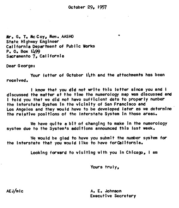
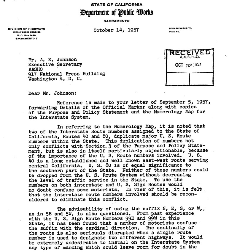
The entirety of the San Bernardino Freeway was assigned as part of California's chargeable Interstate mileage. Chargeable corridors were subject to Federal Highway Administration fund matching based off an allocation of mileage fund matching. The segment of the San Bernardino Freeway from the Santa Ana Freeway to the Golden State Freeway was assigned as part of Chargeable Corridor H. Corridor H also included the segment of the Santa Ana Freeway south of the San Bernardino Freeway to the Golden State Freeway. It isn't fully clear when Chargeable Corridor H was assigned the numbers of Interstate 110 and Interstate 105.
The
September/October 1962 California Highways & Public Works announced the Golden State Freeway was fully complete from Lankershim Boulevard south to the Santa Ana Freeway. The Golden State Freeway from Glendale Boulevard south to Arnold Street is stated to have opened during January 1962 whereas the segment south to Pasadena Avenue opened during March 1962. The completion of the Golden State Freeway from Lankershim Boulevard to the Santa Freeway would see US Route 99 realigned. US Route 99 now followed Interstate 5/LRN 4 on the Golden State Freeway directly to the San Bernardino Freeway bypassing the Pasadena Freeway and Santa Ana Freeway through downtown Los Angeles.
The truncation of US Route 99 from Calexico to the junction of the Golden State Freeway and San Bernardino Freeway in Los Angeles was approved by the AASHO Executive Committee on June 19, 1963. The justification by the California Division of Highways to truncate US Route 99 was to avoid what the agency viewed as confusing multiplexes on the new Interstate corridors of Southern California.
The truncation of US Route 99 was part of the wider 1964 California State Highway Renumbering. The 1964 California State Highway Renumbering eliminated Legislative Route Numbers in favor of field signage, minimized multiplexes, eliminated US Routes which didn't cross the State Line and assigned field signage to former Legislative Route Numbers which lacked it.
US Route 70 was approved to be truncated from Los Angeles to US Route 95 in Blythe by the AASHO on August 26, 1963. The truncation of US Route 70 removed it entirely from the San Bernardino Freeway.


Interstate 110 was defined legislatively during the 1964 State Highway Renumbering as "in Los Angeles from the northerly terminus of Route 105 to the junctions of Routes 5 and 10."
The changes to the US Route System around Los Angeles illustrated above can be seen in effect on the 1964 Division of Highways Map. US Route 99 is seen terminating via Interstate 5 and the Golden State Freeway at Interstate 110/Interstate 10/US Route 60 at the San Bernardino Freeway. What had been US Route 99/US Route 70/US Route 60 on the San Bernardino Freeway between the Santa Ana Freeway and Golden State Freeway is shown assigned as the original Interstate 110.

During August 1965 the corridor of Interstate 110 was deleted as a chargeable mileage. This action was taken due to the San Bernardino Freeway between the Santa Ana Freeway and Golden State Freeway having been already constructed. This measure allowed the Division of Highways to use 0.65 chargeable miles elsewhere in the state.
The AASHO Executive Committee approved US Route 60 to be truncated from downtown Los Angeles to US Route 95 in Blythe on October 2, 1965. The truncation of US Route 60 to Blythe left only Interstate 110 signed on the San Bernardino Freeway between Santa Ana Freeway and Golden State Freeway.
The
1967 Division of Highways Map is the first edition to display US Route 60 removed from the San Bernadino Freeway between the Santa Ana Freeway and Golden State Freeway totally in favor or Interstate 110.
1968 Legislative Chapter 282 deleted the definition of Interstate 110 and consolidated as a spur of Interstate 10. The San Bernardino Freeway between the Santa Ana Freeway and Golden State Freeway appears as an unnumbered State Highway on the
1969 Division of Highways Map.
The second iteration of Interstate 110 would be designated in California during 1981 over the Harbor Freeway south of Interstate 10. The current 0.65 miles of the Interstate 10 Spur on the San Bernardino Freeway between the Santa Ana Freeway and Golden State Freeway can be seen in the Caltrans Postmile Tool. Note, Caltrans recognizes all categories of their highway inventory as "State Routes." To that the spur is not considered part of the Interstate System by the Federal Highway Administration and does not appear in their mileage calculations for Interstate 10.
Part 2; exploring the Interstate 10 Spur
From northbound US Route 101 on the Santa Ana Freeway traffic can access the Interstate 10 Spur via Exit 1D. The spur is signed as Interstate 10 due to functionally acting as a connector to the larger San Bernardino Freeway.


Comments