
Arizona State Route 153 was a 2.12-mile State Highway located in the city of Phoenix along the eastern outskirts of Sky Harbor International Airport. Arizona State Route 153 was largely a limited access facility known as the Sky Harbor Expressway which began at University Drive and terminated to the north at Washington Street. Arizona State Route 153 was commissioned during 1985, had a major planned alignment change in 1989 and opened to traffic in 1992. Arizona State Route 153 was originally planned to continue south of University Drive to Interstate 10, but low traffic counts on the corridor never saw it come to fruition. Arizona State Route 153 was relinquished by the Arizona Department of Transportation to the city of Phoenix during 2007.
The map below depicting Arizona State Route 153 was sourced from Wikipedia.

Part 1; the history of Arizona State Route 153
Arizona State Route 153 and the Sky Harbor Expressway were commissioned as part of the Phoenix Regional Freeway System on April 26, 1985. Arizona State Route 153 was also added to the planned 2005 Maricopa County Regional Transportation Plan. Arizona State Route 153 was originally intended to terminate at Arizona Loop 202 east of what is now Arizona State Route 143. During 1989 the alignment of Arizona State Route 153 north of Sky Harbor Airport to Washington Street was swapped with Arizona State Route 143.
The new planned alignments of Arizona State Route 153, Arizona State Route 143 and Arizona State Route 202 Spur can be seen on an Arizona Department of Transportation document dated April 21, 1989. The planning map depicts Arizona State Route 153 continuing south of University Drive to Interstate 10.

Arizona State Route 153 between University Drive and Washington Street opened as freeway facility during 1992. The original intended terminus of Arizona State Route 153 to Arizona Loop 202 would open as the unsigned Arizona Loop 202 Spur in 1993. The continuation of Arizona State Route 153 to reach Interstate 10 was never pursued due to traffic counts on the corridor being too low.
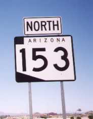
An Arizona State Route 153 shield can be seen in a 1999 photo from arizonaroads.com.
On May 23, 2007, Arizona State Route 153 was removed from the Maricopa Association of Governments Regional Transportation Plan.

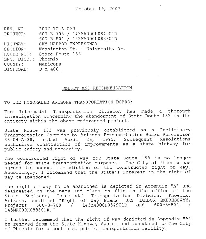
Arizona State Route 153 was relinquished to the city of Phoenix during 2007 and signage was changed to indicate it as part of 44th Street. The October 19, 2007, Resolution of Abandonment of Arizona State Route 153 by the Arizona Department of Transportation can be seen below.


Part 2; a drive on former Arizona State Route 153
Former Arizona State Route 153 northbound begins from University Drive. A westbound University Drive overhead gantry features a greened-out Arizona State Route 153 shield along with signage directing traffic to Sky Harbor International Airport.


Former Arizona State Route 153 begins as a limited access road headed northbound. Despite largely being a limited access facility Former Arizona State Route 153 is signed with an unusually low 40 Mile Per Hour Speed Limit. Former Arizona State Route 153 crosses the Salt River within view of Papago Park and Camelback Mountain.


Former Arizona State Route 153 north of the Salt River intersects the unsigned Arizona State Route 202 Spur (Sky Harbor Boulevard).


Former Arizona State Route 153 continues north of Arizona State Route 202 Spur and becomes a surface road at Madison Street.


The routing of Former Arizona State Route 153 terminated at Washington Street.


Comments