
California State Route 159 was a post 1964-Renumbering State Route which was designated over former segments of California State Route 11 and US Route 66. As originally defined California State Route 159 began at Interstate 5/US Route 99 at the Golden State Freeway in Los Angeles. California State Route 159 followed Figueroa Street, Colorado Boulevard and Linda Vista Avenue to the planned Foothill Freeway. California State Route 159 was truncated during 1965 to existing solely on Linda Vista Avenue where it remained until being relinquished during 1989. California State Route 159 was formally deleted from the State Highway System during 1992.
The history of California State Route 159
Prior to 1933 the Division of Highways was not actively involved in maintaining urban highways outside of occasional cooperative projects. The responsibility for signage of US Routes in cities was thusly given to the Automobile Club of Southern California in the Southern California region. This being the case the signage of US Route 66 in Los Angeles was in flux prior to 1933. For the early movements of US Route 66 in Los Angeles please consult the below blog:
What was to become California State Route 159 was adopted during 1933 as components of Legislative Route Number 165 (LRN 165). LRN 165 was routed from San Pedro to La Canada via Figueroa Street and Linda Vista Avenue. The addition of LRN 165 made the three completed Figueroa Street Tunnels part of the State Highway System and led to the construction of the fourth southernmost tunnel. Figueroa Street once completed between Pasadena and downtown Los Angeles would serve as a much more direct corridor with more traffic capacity than earlier National Old Trails Road.
CAhighways.org on LRN 165
Much of the early US Route system around Los Angeles was heavily altered after 1933. During 1934 US Route 99 was realigned off a multiplex of US Route 66 from Pasadena-San Bernardino (LRN 9) to a new alignment which took it to Redlands via downtown Los Angeles, Pomona and Colton on LRN 26. The attached sketch map implies US Route 66 was aligned through the Figueroa Street Tunnels, Solano Avenue and Broadway to a terminus at US Route 101/Sunset Boulevard.


CAhighways.org has a page dedicated to Interstate 110/California State Route 110 which shows a photo of the fourth Figueroa Street Tunnel under construction. Temporary signage showing US Route 66/US Route 99 and California State Route 11 can be seen in front of the tunnel which is looking southbound. The Temporary signage shows US Route 99/US Route 66 and California State Route 11 jogging from the fourth Figueroa Street Tunnel onto Solano Street onwards to Broadway.

California State Route 11 was one of the original Sign State Routes announced in the August 1934 California Highways & Public Works. California State Route 11 was announced as being aligned on LRN 165 from San Pedro to California State Route 118 near La Canada.

An opening ceremony for the fourth Figueroa Street Tunnel was held on August 4th of 1936 which was featured in the Los Angeles Times. The completion of the fourth Figueroa Street Tunnel connected US Route 99/US Route 66/California State Route 11/LRN 165 directly to US Route 101/LRN 2 at Sunset Boulevard.

The August 1936 California Highways & Public Works announced plans for the North Figueroa Street Viaduct and details the planned Arroyo Seco Parkway (LRN 205). The North Figueroa Street Viaduct would eliminate the jog in US Route 99/US Route 66/California State Route 11/LRN 165 on Arroyo Seco Boulevard and Riverside Drive. Note: LRN 205 and the Arroyo Seco Parkway were defined by 1935 Legislative Chapter 426 as a State Highway.


The April 1937 California Highways & Public Works features construction of the North Figueroa Street Viaduct over the Los Angeles River. The North Figueroa Street Viaduct is stated in the article stub to be nearing completion.


The 1938 Division of Highways Map displays the location of California State Route 11 and US Route 66 on LRN 165. California State Route 11 can be seen following Linda Vista Avenue south from California State Route 118 to US Route 66 at Colorado Street. From Colorado Street, California State Route 11/US Route 66 can be seen following Figuroa Street to the North Figuroa Street Viaduct.

The completed North Figueroa Street Viaduct appears on the cover of the February 1938 California Highways & Public Works.

The June 1939 California Highways & Public Works notes four of seven construction contracts of the Arroyo Seco Parkway were complete.


A partially completed segment of the Arroyo Seco Parkway appears in the October 1939 California Highways & Public Works.

The partially completed Figueroa Street/Temple Street underpass is shown in the November 1939 California Highways & Public Works. The article stub notes the Arroyo Seco Parkway was anticipated to be completed during 1941.


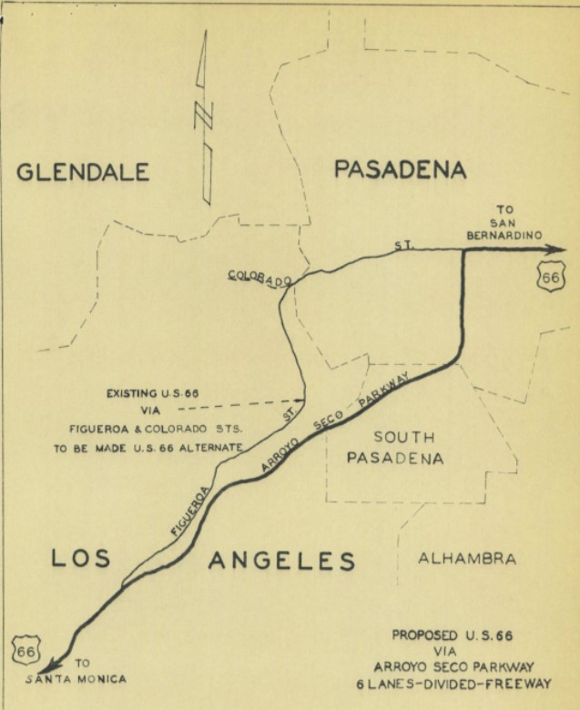
The August 1940 California Highways & Public Works announced the opening of a 3.7-mile unit of the Arroyo Seco Parkway from Orange Grove Avenue in south Pasadena to Avenue 40 in Los Angeles. The initial segment of the Arroyo Seco Parkway served as a new alignment of US Route 66.


On September 7th, 1940, the California State Highway Engineer submitted a request to reroute US 66 onto the Arroyo Seco Parkway and redesignate older route on Figueroa Street co-signed with California State Route 11 as US Route 66A. On October 9th, 1940, the AASHO Executive Secretary responded and advised that seeking AASHO approval to reroute US Route 66 was unnecessary given the rerouting was entirely in a California Metropolitain Area. While not directly stated the AASHO Executive Secretary did not disapprove of the existence of US Route 66A.


A completed segment of the Arroyo Seco Parkway appears on the cover of the October 1940 California Highways & Public Works.

In the run up to the 1964 State Highway Renumbering many of the US Routes within California were truncated. US Route 66 was approved to be truncated from Santa Monica to US Route 95 in Needles by the AASHO on November 14, 1963. US Route 66 was effectively immediately removed from the Pasadena Freeway with signage being truncated to Pasadena. Signage of US Route 66 would not be truncated from Pasadena to US Route 95 until Interstate 40 was completed through the Bristol Mountains in 1972.


US Route 66A which was concurrent with California State Route 11 between the Arroyo Seco Parkway and Pasadena was approved to be deleted by the AASHO Executive Committe on October 20, 1963.


A. From Route 5 near the Los Angeles River to Route 134.
B. From Route 134 to Route 210 near La Canada.
California State Route 159 first appears on the 1964 Division of Highways Map. California State Route 159 is shown following Figuroa Street north from Interstate 5/US Route 99 at the Golden State Freeway to California State Route 134 at Colorado Boulevard. From California State Route 134 the alignment of California State Route 159 can be seen following Linda Vista Avenue north to the planned Foothill Freeway. Note: California State Route 11 was realigned over former US Route 66 to Pasadena via the Pasadena Freeway (the Arroyo Seco Parkway).

"This route shall cease to be a state highway when Route 210 freeway is completed from Route 134 to Linda Vista Avenue and the commission relinquishes that portion of present Route 210 from Route 134 to Linda Vista Avenue."
California State Route 159 on Linda Vista Avenue was formally relinquished by the State on July 14, 1989. California State Route 159 no longer appears on Linda Vista Avenue on the 1990 Caltrans Map.

California State Route 159 was formally deleted by way of 1992 Legislative Chapter 1243.
Comments