
Unbuilt California State Route 256


California State Route 256 was a never constructed western bypass of downtown Roseville of Placer County.  California State Route 256 was created via 1965 Legislative Chapter 1372 and appears to have been a conceptual replacement for what was US Route 99E.  The adopted routing of California State Route 256 was dropped in 1976 and it was deleted by the State Legislature during 1994.  


The history of California State Route 256

As noted in the intro, 1965 Legislative Chapter 1372 added California State Route 256 (CA 256) to the State Highway System as a western freeway bypass of Roseville between Interstate 80 and CA 65/former US Route 99E.  The planned route of CA 256 appears for the first time on the 1966 Division of Highways Map.  CA 256 never appears in any volume of the California Highways & Public Works, and it isn't clear when it was assigned an adopted routing.  Notably 1966 is the last Division of Highways Map which any segment of US 99 appears in California.  


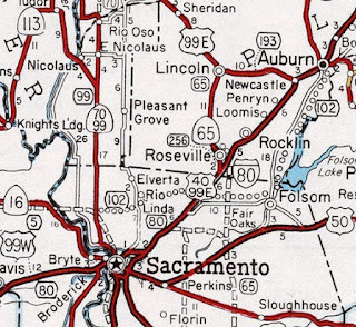
The planned western freeway bypass route of CA 256 around downtown Roseville was cancelled during 1976.  Although CA 256 does not appear on the 1977 Caltrans Map it wasn't deleted until 1994 Legislative Chapter 1220. 

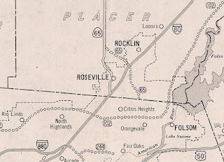
The September 1984 Final Environmental Impact Report for eastern CA 65 Roseville Bypass notes that construction of CA 256 would have been too costly largely due to having to cross the Southern Pacific Railroad Switch Yard.  

Comments

Popular posts from this blog

Abandoned US Route 40 in the Truckee River Canyon

Within the Truckee River Canyon in the Sierra Nevada range numerous abandoned portions of US Route 40 can be found alongside modern Interstate 80.   This segment of highway was opened during 1926 as a bypass of the Dog Valley Grade which carried the early North Lincoln Highway and Victory Highway. The corridor of the Truckee River Canyon State Highway would be assigned as US Route 40 when the US Route System was commissioned during November 1926. During 1958 the segment of Interstate 80 between Boca, California and the Nevada state line was complete. When Interstate 80 opened east of Boca numerous obsolete portions of US Route 40 were abandoned. Some of these abandoned segments have been incorporated into the Tahoe-Pyramid Trail.  Part 1; the history of US Route 40 in the Truckee River Canyon The Truckee River Canyon for centuries has been an established corridor of travel known to native tribes crossing the Sierra Nevada range.  The first documented wagon crossi...

Former US Route 50 and the Pioneer Route Lincoln Highway on Johnson's Pass Road

Johnson's Pass Road is one of the oldest highway corridors in California.  Johnson's Pass was part of the Lake Tahoe Wagon Road as it was completed during 1856 over the Sierra Nevada.  The pass would later be incorporated into the Pioneer Branch of the Lincoln Highway in 1913 and US Route 50 in 1926.  Johnson's Pass Road would be bypassed by a new alignment of US Route 50 over Echo Summit in 1938.  A replacement of the Meyers Grade east of Johnson's Pass would be opened to traffic in 1947.   Johnson's Pass Road remains accessible to traffic and is still signed by the Lincoln Highway Association.  Pictured as the blog cover is the view from the top of Johnson's Pass Road overlooking modern US Route 50 and Lake Tahoe.   Part 1; the history of Johnson's Pass Much of the history of what become the Lake Tahoe Wagon Road is discussed in the  September 1950 California Highways & Public Works  during its Centennial Edition.  The or...

Former California State Route 41 past Bates Station

When California State Route 41 was commissioned during August 1934 it was aligned along the then existing Fresno-Yosemite Road north of the San Joaquin River.  Within the Sierra Nevada foothills of Madera County, the original highway alignment ran past Bates Station via what is now Madera County Road 209, part of eastern Road 406 and Road 207.   Bates Station was a stage station plotted during the early 1880s at what was the intersection of the Coarsegold Road and Stockton-Los Angeles Road.   The modern alignment bypassing Bates Station to the east would be reopened to traffic during late 1939.   Part 1; the history of California State Route 41 past Bates Station Bates Station was featured as one of the many 1875-1899 Madera County era towns in the May 21, 1968, Madera Tribune .  Post Office Service at Bates Station is noted to have been established on November 23, 1883 and ran continuously until October 31, 1903.  The postal name was sourced...