The past four years I've frequently driven the entirety of Interstate 5 in San Joaquin Valley and Sacramento Valley. I-5 from Wheeler Ridge north to a segment near of Woodland is known as the "West Side Freeway."

The West Side Freeway segment of I-5 refers to an approximately 330 mile portion of the highway from the split with CA 99 at Wheeler Ridge north to the convergence with I-505 near Woodland.


Part 1; the history of the West Side Freeway and the split of I-5W/I-5E
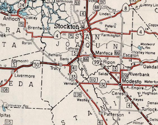
In the 1947 Interstate plan I-5 was to be routed up US 99 where it would have split into I-5W and I-5E in Modesto. I-5W was to planned to use the following current state highways:
- Modern CA 132 west to I-580.
- Modern I-580 west to I-80.
- Modern I-80 east to I-505.
- Modern I-505 to I-5.
As the second Interstate System was being drafted the path of I-5 was shifted to the western part of San Joaquin Valley which was planned as Legislative Route 238. I-5W was planned to split from I-5 at the present junction of CA 132/I-5. I-5E would have split from I-5W at the present junction of CA 132/I-5 and converged again at what is now I-505. Legislative Route 238 was added to the State Highway System in 1957 according to CAhighways.
The initial planned routing of LRN 238 first appears on the 1958 Division of Highways Map. Note; much of the initial planned route of LRN 238 followed a more centralized path through San Joaquin Valley.


During the 1964 State Highway Renumbering I-5W/I-5E were dropped and mainline I-5 was routed entirely on what had been LRN 238. As noted above I-5W became; CA 132, I-580, I-80 and I-505. That said; I-5W was definitely signed in-field along the current corridor I-580 between Tracy and Oakland as evidenced by this photo from the July/August 1962 California Division of Highways Guide. The photo shows I-5W on the current MacArthur/I-580 freeway near Broadway in Oakland.

I-5, I-580, I-80, and I-505 can all be seen for the first time on the 1964 Division of Highways Map where the split of I-5W/I-5E was initially planned.


I-5 between CA 152 north to the split with I-580 are shown as completed on the 1967 Division of Highways Map.

A portion of I-5 south of CA 46 is shown open on the 1969 Division of Highways Map.

I-5 is shown completed between CA 119 north to CA 46 on the 1970 Division of Highways Map.

A segment of I-5 north of CA 41 is shown open on the 1970 Division of Highways Map.

I-5 between CA 99 in Wheeler Ridge north to planned CA 235 near Stockton is shown open on the 1975 Caltrans State Highway Map.


The 1975 Caltrans Map also shows I-5 completed from CA 160 north to I-505.

The 1977 Caltrans State Highway Map shows I-5 completed north of Stockton near the vicinity of CA 12.
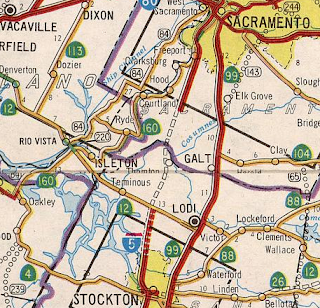
The 1979 Caltrans State Highway Map shows I-5 completed from Stockton north to Sacramento. The opening of I-5 north of Stockton to Sacramento marked the completion of the West Side Freeway.

Part 2; a drive on the West Side Freeway from CA 198 north to I-580
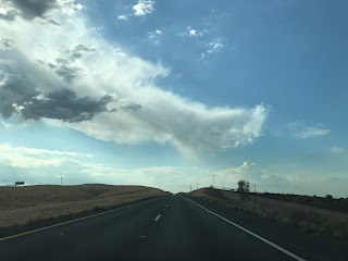
My photos of I-5 on the West Side Freeway are somewhat limited and I plan to expand on this section in the near future. In interim the photo log begins from CA 198 westbound in Fresno County approaching I-5 northbound at Harris Ranch at Exit 334.


Sacramento is signed as 181 miles northbound on I-5. Interestingly San Francisco is used as a control city on I-5 despite it being far to the west.

At Exit 337 I-5 northbound has a junction with CA 33 southbound as well as CA 145.


CA 33 northbound multiplexes I-5 northbound to Exit 349 at Derrick Avenue.


At Exit 357 northbound I-5 meets Kamm Avenue, Manning Avenue at Exit 365, Panoche Road at Exit 368, and Russell Avenue at Exit 372. At Exit 379 I-5 northbound meets County Route J1 at Exit 379/Shields Avenue.

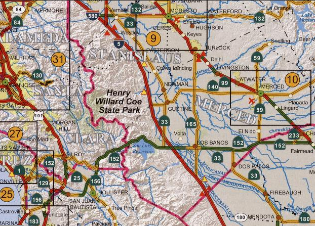
I-5 northbound meets Nees Avenue at Exit 385 and enters Merced County. I-5 northbound passes by a Rest Area and the Dos Amigos Vista before Exit 391 for CA 165.


At Exit 403A/Exit 403B I-5 northbound meets CA 152/CA 33. Given that the I-5/CA 152/CA 33 is among the oldest on the West Side Freeway is essentially substandard and very narrow.

I-5 northbound crosses the California Aqueduct and meets CA 33 again at Exit 407 in Santa Nella.


I-5 north of Santa Nella has a weigh station.


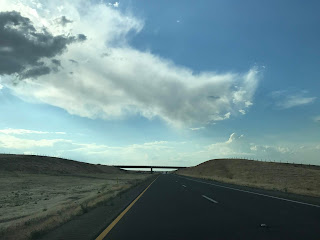
I-5 northbound ascends to the foothills of the Diablo Range and meets CA 140 at Exit 418.


I-5 north of CA 140 crosses the Stanislaus County Line. San Francisco is signed as being 99 miles away.


I-5 northbound continues as a Scenic Corridor and meets County Route J18 at Exit 423 for Stuhr Road.


I-5 north Exit 430 accesses Fink Road


I-5 northbound crosses paths with another Vista Point before meeting County Route J17 on Sperry Avenue on the outskirts of Patterson.


I-5 northbound meets County Route J16 at Exit 441 for Howard Road.


I-5 northbound passes by another Rest Area approaching the split for I-580 at Exit 446. At the I-580 split the route of I-5 northbound enters San Joaquin County.


The West Side Freeway segment of I-5 refers to an approximately 330 mile portion of the highway from the split with CA 99 at Wheeler Ridge north to the convergence with I-505 near Woodland.


Part 1; the history of the West Side Freeway and the split of I-5W/I-5E
In the 1947 Interstate plan I-5 was to be routed up US 99 where it would have split into I-5W and I-5E in Modesto. I-5W was to planned to use the following current state highways:
- Modern CA 132 west to I-580.
- Modern I-580 west to I-80.
- Modern I-80 east to I-505.
- Modern I-505 to I-5.
As the second Interstate System was being drafted the path of I-5 was shifted to the western part of San Joaquin Valley which was planned as Legislative Route 238. I-5W was planned to split from I-5 at the present junction of CA 132/I-5. I-5E would have split from I-5W at the present junction of CA 132/I-5 and converged again at what is now I-505. Legislative Route 238 was added to the State Highway System in 1957 according to CAhighways.
The initial planned routing of LRN 238 first appears on the 1958 Division of Highways Map. Note; much of the initial planned route of LRN 238 followed a more centralized path through San Joaquin Valley.


During the 1964 State Highway Renumbering I-5W/I-5E were dropped and mainline I-5 was routed entirely on what had been LRN 238. As noted above I-5W became; CA 132, I-580, I-80 and I-505. That said; I-5W was definitely signed in-field along the current corridor I-580 between Tracy and Oakland as evidenced by this photo from the July/August 1962 California Division of Highways Guide. The photo shows I-5W on the current MacArthur/I-580 freeway near Broadway in Oakland.

I-5, I-580, I-80, and I-505 can all be seen for the first time on the 1964 Division of Highways Map where the split of I-5W/I-5E was initially planned.


I-5 between CA 152 north to the split with I-580 are shown as completed on the 1967 Division of Highways Map.

A portion of I-5 south of CA 46 is shown open on the 1969 Division of Highways Map.

I-5 is shown completed between CA 119 north to CA 46 on the 1970 Division of Highways Map.

A segment of I-5 north of CA 41 is shown open on the 1970 Division of Highways Map.

I-5 between CA 99 in Wheeler Ridge north to planned CA 235 near Stockton is shown open on the 1975 Caltrans State Highway Map.


The 1975 Caltrans Map also shows I-5 completed from CA 160 north to I-505.

The 1977 Caltrans State Highway Map shows I-5 completed north of Stockton near the vicinity of CA 12.

The 1979 Caltrans State Highway Map shows I-5 completed from Stockton north to Sacramento. The opening of I-5 north of Stockton to Sacramento marked the completion of the West Side Freeway.

Part 2; a drive on the West Side Freeway from CA 198 north to I-580
My photos of I-5 on the West Side Freeway are somewhat limited and I plan to expand on this section in the near future. In interim the photo log begins from CA 198 westbound in Fresno County approaching I-5 northbound at Harris Ranch at Exit 334.


Sacramento is signed as 181 miles northbound on I-5. Interestingly San Francisco is used as a control city on I-5 despite it being far to the west.

At Exit 337 I-5 northbound has a junction with CA 33 southbound as well as CA 145.


CA 33 northbound multiplexes I-5 northbound to Exit 349 at Derrick Avenue.


At Exit 357 northbound I-5 meets Kamm Avenue, Manning Avenue at Exit 365, Panoche Road at Exit 368, and Russell Avenue at Exit 372. At Exit 379 I-5 northbound meets County Route J1 at Exit 379/Shields Avenue.

I-5 northbound meets Nees Avenue at Exit 385 and enters Merced County. I-5 northbound passes by a Rest Area and the Dos Amigos Vista before Exit 391 for CA 165.


At Exit 403A/Exit 403B I-5 northbound meets CA 152/CA 33. Given that the I-5/CA 152/CA 33 is among the oldest on the West Side Freeway is essentially substandard and very narrow.

I-5 northbound crosses the California Aqueduct and meets CA 33 again at Exit 407 in Santa Nella.


I-5 north of Santa Nella has a weigh station.


I-5 northbound ascends to the foothills of the Diablo Range and meets CA 140 at Exit 418.


I-5 north of CA 140 crosses the Stanislaus County Line. San Francisco is signed as being 99 miles away.


I-5 northbound continues as a Scenic Corridor and meets County Route J18 at Exit 423 for Stuhr Road.


I-5 north Exit 430 accesses Fink Road


I-5 northbound crosses paths with another Vista Point before meeting County Route J17 on Sperry Avenue on the outskirts of Patterson.


I-5 northbound meets County Route J16 at Exit 441 for Howard Road.


I-5 northbound passes by another Rest Area approaching the split for I-580 at Exit 446. At the I-580 split the route of I-5 northbound enters San Joaquin County.


Comments