Modern US Route 97 begins in the City of Weed, California at it's southern terminus over what was former US Route 99 on Weed Boulevard. From the City of Weed US Route 97 northbound passes by the foot of Mount Shasta towards Macdoel and Dorris where it crosses the Oregon State Line. In total 54 of the 663 miles of US Route 97 are found within the State of California. Notably the original terminus of US Route 97 was found in Jackson County, Oregon at Emigrant Lake near Ashland. Pictured above US Route 97 can be seen facing southward towards Mount Shasta in 1959.
Part 1; the history of shifting terminus of US Route 97
When the US Route System was formally approved by the United States Secretary of Agriculture during November of 1926 the southern terminus of US Route 97 ("US 97") could be found in Oregon. Specifically US 97 terminated at US 99 south of Ashland of Jackson County near the Emigrant Lake Reservoir. As originally defined US 97 followed Dalles-California Highway #4 southward into Klamath Falls and westward via the Green Springs Highway #21 towards US 99 near Ashland. The southern terminus of US 97 at US 99 near Ashland can be seen on the
1927 National Map Company paved road map.
According the
History Oregon State Highways document Dalles-California Highway #4 and Green Springs Highway #21 were part of the original run of Oregon State Highways designated during November 1917. Notably Dalles California #4 originally terminated at Klamath Falls and was extended the California State Line near Malin largely over what is now Oregon Route 39 during 1919.
Legislative Route Number 72 ("LRN 72") was adopted by the California State Legislature via Legislative Chapter 82 as new State Highway beginning in Weed and terminating to the north at the Oregon State Line. LRN 72 was an adoption of then existing Weed-Klamath Falls Highway. During November of 1931 Midland Highway #420 was added to the Oregon State Highway System between Klamath Falls south to the California State Line.
The
March 1933 California Highways & Public Works notes the progress of paving LRN 72. $136,000 dollars had been allocated by the California Highway Commission to pave LRN 72 south from the Oregon State Line to the extent the funding would be exhausted. LRN 72 between the Oregon State Line south to Dorris is stated to be a very poor state of repair.
The first map reference to US 97 in California appears in the
August 1934 California Highways & Public Works. US 97 can be seen aligned over LRN 72 from Weed to the Oregon State Line on a map showing the first run of the California Sign State Routes.
The first reference by the State of California pertaining US 97 being shifted to a new southern can be found on a September 6th, 1934 letter by the California State Highway Engineer to the AASHO Executive Secretary. US 97 is shown to follow Midland Highway #420 and LRN 72 south of Klamath Falls to Weed via Dorris. According to CAhighways.org the shift of
US 97 to a new southern terminus in California was approved during the June 1934 AASHO Executive Committee Meeting.
A sketch of US 97 via LRN 72 from the Oregon State Line to Weed appears in a September 11th, 1934 letter by the California State Highway Engineer to the AASHO Executive Secretary. This sketch shows much of existing LRN 72 was planned to be cutoff by a new alignment which bypassed numerous railroad sidings in favor of route via Grass Lake. Existing LRN 72 is noted to have been upgraded to a standard which would permit major through traffic.


US 97 is shown to be realigned to the California State Line south of Klamath Falls to LRN 72 on the 1934 Oregon State Highway Department Route Descriptions (courtesy Johnathan Ledbetter).
According to the Oregonian the original alignment of US 99 over Siskiyou Pass via the grade of the Pacific Highway (Pacific Highway #1) became inadequate to meet the needs of modern highway traffic by the time the 1930s began. This led to a new alignment for US 99 between Ashland to Sikiyou Pass being plotted out. The first segment of this new alignment of US 99 from Ashland to Wall Creek broke ground in October of 1933. This new alignment of US 99 may have been part of the reasoning of why US 97 was shifted to a new terminus in Weed, California during 1934. The 1935 Goshua West Coast Road Map shows US 97 shifted off it's original route to California and being replaced with Oregon Route 66 over Green Springs Highway #21.
The 1935 Gousha Oregon Map shows the shift of US 97 and the newly designated Oregon Route 66 in greater detail.
The 1935 Division of Highways Map of Siskiyou County shows the initial alignment of US 97 on LRN 72. The original alignment of US 97 can be observed entering California via Dorris southward. From Dorris US 97 passed through Macdoel and Mount Hebron southward via Old State Highway towards Bray. From Bray US 97 traveled westward on Forest Route 8001, Forest Route 44N25, and over Butte Creek via Tenant Road. US 97 followed Alder Creek Road and Deer Creek Mountain Road where it joined the modern highway alignment at the siding known as Cougar. Notably all the communities described were Southern Pacific Railroad siding which were largely plotted out circa 1907 when a line was being built Weed and the Oregon State Line. Existing LRN 72 and early US 97 in California were essentially an overlay of the Southern Pacific Railroad frontage facilities.
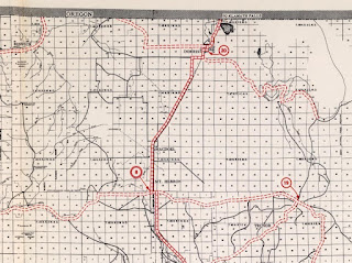
US 97/LRN 72 is shown to be realigned onto a more direct route from Cougar north to Macdoel on the
1938 Division of Highways State Map.. The new alignment of US 97/LRN 72 cut off much of the original alignment through Bray and shortened the highway by seven miles within California.
The
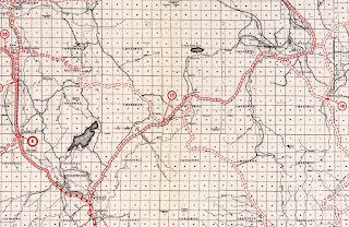
December 1938 California Highways & Public Works details the realignment of US 97/LRN 72 between Cougar north to Macdoel. The Cougar-Macdoel realignment of US 97/LRN 72 is stated to have opened on November 2nd, 1938 and was twenty four miles in overall construction scope.
During 1939 California Dalles Highway #4 was realigned from Malin south of Klamath Falls over much of Midland Highway #420 and US 97 to the California State Line.

The
March/April 1955 California Highways & Public Works discusses improvements made to US 97/LRN 72 through Dorris north to the Oregon State line. US 97/LRN 72 is stated to have been largely modernized atop much of the existing highway alignment via the first major construction project on the highway since the late 1930s. The modernization of the Dorris-Oregon State Line segment of US 97/LRN 72 is stated to have been completed during December of 1954. The new grade of US 97/LRN 72 over Dorris Hill was constructed with a four lane expansion in mind.


During the 1964 California Highway Renumbering the Legislative Route Numbers were dropped in favor of field signage. Originally no changes to the alignment of US 97 occurred as US 99 was initially retained despite much of it's alignment due to be consumed by Interstate 5 between Red Bluff and the Oregon State Line. The AASHO Renumbering database shows that US 99 was approved to be truncated out of California to Ashland, Oregon by the AASHO Executive Committee on June 29th, 1965.
Thusly,
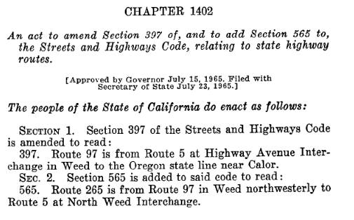
California Legislative Chapter 1402 was approved by the Governor on July 15th, 1965. Legislative Chapter 1402 extended US 97 south through downtown Weed via Weed Boulevard to the Interstate 5 at Highway Avenue Interchange. Legislative Chapter 1402 also created California State Route 265 which was routed north from US 97 via Weed Boulevard to the North Weed Interchange of Interstate 5.
Part 2; exploring the original terminus of US Route 97 at Emigrant Lake near Ashland, Oregon
Modern Oregon Route 273 (former US 99) descends from Siskiyou Pass via the Steinman Overcrossing and terminates at Oregon Route 66 at the southern banks of Emigrant Lake.
Former US 99 can be followed north from the modern Oregon Route 273/Oregon Route 66 junction into Emigrant Lake. When the waters of Emigrant Lake are low one can still find the original US 99/US 97 junction. US 97 entered Emigrant Lake via what is now Old Green Springs Highway.
The original Emigrant Creek Reservoir was constructed in 1924. The Bureau of Reclamation later expanded the Emigrant Creek Reservoir in 1960 which consumed the original US 99/US 97 junction. The Google Earth image below depicts the original US 99/US 97 junction at the bend in Hill Creek located in the Emigrant Lake Reservoir.
Part 3; exploring the second and third southern terminus points of US Route 97 in Weed, California
From Interstate 5 northbound former US 99 on Weed Boulevard can be accessed via Exit 747 to US 97. Approaching Exit 747 Interstate 5 northbound traffic is notified that US 97 is also Historic US 99. Exit 747 serves as the modern southern terminus of US 97.
US 97 traffic is advised Bend and Klamath Falls in Oregon are the primary Control Cities from Weed. As US 97 begins it is co-signed with Interstate 5 Business. US 97 between Interstate 5 Exit 747 and California State Route 265 on Weed Boulevard carries supplemental "L" suffixed Postmiles given it was extended after 1964.


The Weed Souvenir Shop can be found at the corner of Weed Boulevard and Boise Street at US 97 Postmile SIS L0.144. The Weed Souvenir Shop sells numerous trinkets which are popular with travelers who are entertained by the City Name. The City of Weed is named after after it's founder Abner Weed. In the 19th Century Abner Weed noted that the winds near the present site of the City of Weed were especially good for drying lumber. In 1897 Abner Weed purchased the Siskiyou Lumber & Mercantile Mill in addition to 280 acres of land where the City of Weed now stands. The community of Weed was plotted along the Central Pacific Railroad Line between the communities of Edgewood and Mount Shasta City. The lumber mill at Weed led to the community growing rapidly during the early 20th Century. In 1961 Weed incorporated as a City.
Who doesn't?
US 97 northbound on Weed Boulevard carries numerous Historic US 99 shields.
US 97 continues on Weed Boulevard until splitting away towards Oregon at the California State Route 265 junction at Postmile SIS L0.43. North of CA 265 the Postmiles of US 97 reset to 0. The junction of US 97 and California State Route 265 serve as the 1934 southern terminus of the highway at what was US 99.
Part 4; US Route 97, Mount Shasta and the Volcanic Legacy Scenic Byway
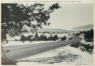
At approximately Postmile SIS 19.000 the Mount Shasta View Point can be found on US 97 north of Weed. The entirety of US 97 in California part of the Volcanic Legacy Scenic Byway in California The photo below was taken during May of 2014 from the Mount Shasta View Point when the 14,179 stratovolcano was fully visible.
A similar view to the Mount Shasta View Point on US 97 can be seen in the December 1938 California Highways & Public Works.
The Mount Shasta View Point on US 97 as seen in the November/December 1959 California Highways and Public Works.
The
Volcanic Legacy Scenic Byway consists of over 500 miles of roadways in the Cascade Range of Oregon and California which crosses paths with many of the notable volcanic peaks.
Version History
- Originally published on 9/15/18 under the title of; Volcanic Legacy Scenic Byway, US Route 97, California State Route 161, Tule Lake and Lava Beds National Monument.
- Updated and republished on 10/3/21 under the title of; Exploring the southern terminus points of US Route 97 in Oregon and California.


Comments