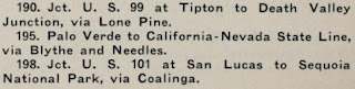
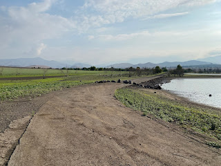
East of the City of Porterville the alignment of California State Route 190 follows the Tule River watershed into the Sierra Nevada Mountains. In modern times California State Route 190 east of Porterville climbs south of the Lake Success Reservoir towards Springville. Much of the original alignment of California State Route 190 within the Lake Success Reservoir can still be hiked, especially in drier years. Pictured above is the original alignment of California State Route 190 facing northward along the western shore of Lake Success.
Part 1; the history of California State Route 190 through Lake SuccessThe corridor of California State Route 190 ("CA 190") east of Porterville to Springville follows the watershed of the Tule River. The Tule River watershed between Porterville and Springville would emerge as a source of magnesite ore near the turn of the 20th Century. The magnesite ore boom would lead to the development of a modern highway in the Porterville-Springville corridor. The Southern Pacific Railroad would also develop the Success-Springville Branch along the Tule River in the Porterville-Springville corridor. The Southern Pacific Railroad would plot the sidings of Plano, Success and Clavicle along the Porterville-Springville corridor. The existing highway along with Success-Springville Branch between Porterville and Springville can be seen on the 1917 California State Automobile Association Map.
The highway corridor between Porterville-Springville would emerge as part of the planned route of the
Lone Pine-Porterville High Sierra Road. The initial survey for the route of the Lone Pine to Porterville High Sierra Road was conducted in 1923 and was to be funded by; Tulare Couny, Kern County, and Inyo County. Road building input was provided to the aforementioned counties by the California Division of Highways in addition to the Automobile Club of Southern California.
Ultimately construction of the Lone Pine-Porterville High Sierra Road began in 1927 and included a north branch towards Visalia. The initial route of the Lone Pine-Porterville High Sierra Road followed the existing Porterville-Springville highway and what is now Tulare County Route J37/Balch Park Road via the North Fork Tule River. During 1933 the State of California adopted the concept of the Lone Pine-Porterville High Sierra Road as part of
Legislative Route Number 127 ("LRN 127"). LRN 127 was adopted under Legislative Chapter 767 with the following definition:
- [LRN 4/US Route 99] near Tipton, via Porterville and Camp Nelson to [LRN 23] near Lone Pine
- [LRN 31] to Death Valley and connection to the California-Nevada State Line
- [LRN 23} near Lone Pine to Death Valley
Despite LRN 127 adopting a new alignment east of Springville via the Middle Fork Tule River the existing corridor between Porterville-Springville was made a segment of State Highway. The entirety of LRN 127 would be announced as CA 190 in the
August 1934 California Highways & Public Works.
The
1935 Division of Highways Map of Tulare County details the original alignment of CA 190/LRN 127 east of Porterville to Springville. CA 190/LRN 127 east Main Street in Porterville followed Date Avenue, Springville Avenue and Avenue 146 towards what is now site of the Success Dam. From the site of the Success Dam CA 190/LRN 127 followed what is now an abandoned road past the Southern Pacific Siding of Success which emerges onto Holdridge Drive. CA 190/LRN 127 continued east on Holdridge Drive to modern Tulare County Route J28/Avenue 176. The original alignment of CA 190/LRN 127 followed modern Tulare County Route J28 via Avenue 176 and Road 320 to modern CA 190 near the former Southern Pacific Siding of Clavicle.

The Southern Pacific Railroad would file abandonment paperwork for the 2.4 miles of the Success-Springville Branch between Clavicle and Springville during January of 1935. An additional 5.8 miles of the Success-Springville Branch between Success-Clavicle would be abandoned by the Southern Pacific Railroad during June of 1941. The remaining 6.66 miles of Success-Springville Branch would be abandoned by the Southern Pacific Railroad between Porterville and Success during August of 1957. The Porterville-Success segment of the Success/Springville Branch was was abandoned to make way for the upcoming Success Reservoir which was to be constructed by the
Army Corps of Engineers.
The
November/December 1957 California Highways & Public Works lists the relocation of CA 190/LRN 127 from Hospital Road to Worth Road as being funded for the 1958-59 Fiscal Year under Tulare County projects. The Hospital Road-Worth Road realignment of CA 190/LRN 127 is listed as being located west of the future Success Reservoir.
The
September/October 1958 California Highways & Public Works notes in a District VI report that 7 miles of CA 190/LRN 127 was to be relocated east of Porterville to make way for the Success Reservoir. The relocation of CA 190/LRN 127 through the Success Reservoir site is stated to be funded by the Federal Government at a cost of $1,700,000 and was anticipated to be completed by Fall 1958.


The completed realignment of CA 190/LRN 127 south of the Success Reservoir site appears for the first time on the
1960 Division of Highways Map. The Army Corps of Engineers would complete the Success Reservoir in 1961 which began to flood over much of the original alignment of CA 190/LRN 127 via the waters of Lake Success. In 1964 the Legislative Route Numbers were dropped during the California State Highway renumbering. Functionally since late 1958 there has been no changes to the alignment of CA 190 at the site of the Lake Success Reservoir.
Part 2; hiking former California State Route 190 at the bottom of Lake Success
Modern Tulare County Route J28 from it's origin point at modern CA 190 carries the original alignment of the latter westward via Road 320 and Mountain Road 176. The original alignment of CA 190 diverges from Tulare County Route J28 at Holdridge Drive.
Holdridge Drive carries the original alignment of CA 190 westward to a dead end gate which serves as a trailhead to the Success Lake Gill Cove Unit Wildlife Management Area.
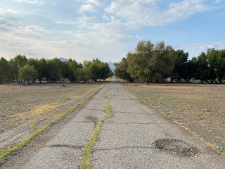
Old CA 190 from the Success Lake Gill Cove gate is not marked as a trail but follows a generally southwestern course toward Lake Success. The Old CA 190 trail begins by crossing a small undated culvert.
Old CA 190 westward intersects what was once Road 296.
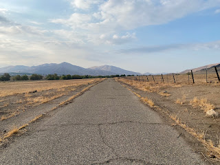
Old CA 190 generally swings southward from former Road 296 via a segment which carries an obvious asphalt surface top layer. White centerline stripes can be observed on Old CA 190 until it disappears under the silt of Lake Success.
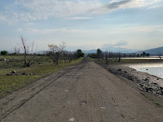
Approaching the bed of the Tule River Old CA 190 largely disappears underneath a layer of silt from Lake Success. The grade of Old CA 190 can be faintly traced heading southwest towards Success Dam. The site of the Southern Pacific Railroad Siding of Success would have been several hundred yards ahead in the photo below.
Following Old CA 190 southwest becomes difficult for about a mile given it is so heavily covered with silt.
Old CA 190 reemerges as it's grade gains elevation and begins to jog westward.
A southward view of Success Dam from Old CA 190.
Old CA 190 crosses a long abandoned culvert and turns south towards Success Dam.
Old CA 190 climbs in elevation and jogs southward to Success Dam. Much of the later asphalt surface of Old CA 190 has eroded away to reveal older concrete slabs. Some of the concrete slabs are slowly being eroded away and are subsiding.
The grade of Old CA 190 disappears approaching Success Dam. Success Dam is a 158 foot tall earth based structure which contains a volume of 82,000 acre feet and a maximum reservoir area of 2,450 acres. Success Dam was constructed under provisions of Flood Control Act of 1944 and was largely intended to control downstream flooding on the Tule River.
The north/northeast journey on Old CA 190 returning to Holdridge Drive depicted below and is approximately 3 miles long.


Comments
I’m wondering if anyone knows what the ruins just north of the north boat ramp were. This is the cement foundation that’s visible some of the year. It’s a very special spot for my husband and I.
Again, thank you so much!