Part 4 of the Southeast Trip was a long approximately 370 mile day along US Route 98 on the Gulf Coast of Florida.

I took a ton of shield pictures given that I was on US 98 for such a long time. Rather than attempt to post or talk about all the routes, I'll just limit to major junction and link over my US 98 Flickr album:
US 98 between FL 589 and Fort Walton Beach on Flickr
I started the morning somewhat early and made my way up to the north terminus of FL 589 on the Suncoast Parkway and turned onto US 98 west.

US 98 quickly enters Citrus County and approaches US 19 north. Both US 98 and US 19 multiplex to the north to Crystal River on Suncoast Boulevard.


US 98/19 first passes through Homosassa Springs where it junctions County Route 490 and CR 490A. Homosassa Springs is mostly known for the Homosassa Springs State Wildlife Reserve where manatees is easily observed. The village of Homosassa to the west dates back to a sugar plantation from the 1850s.

Entering Crystal River US 98/19 junctions Florida State Road 44. FL 44 is just over 100 miles long and ends at US 441 in Leesburg to the east.

Some obviously older buildings on Citrus Avenue in downtown Crystal River. Crystal River dates back to the 1840s and was settled after the second Seminole War. Crystal River is named after a short river which outlets into the Gulf of Mexico. Crystal River is widely known for the Crystal River 3 Nuclear Power Plant which has had numerous issues the past decade.

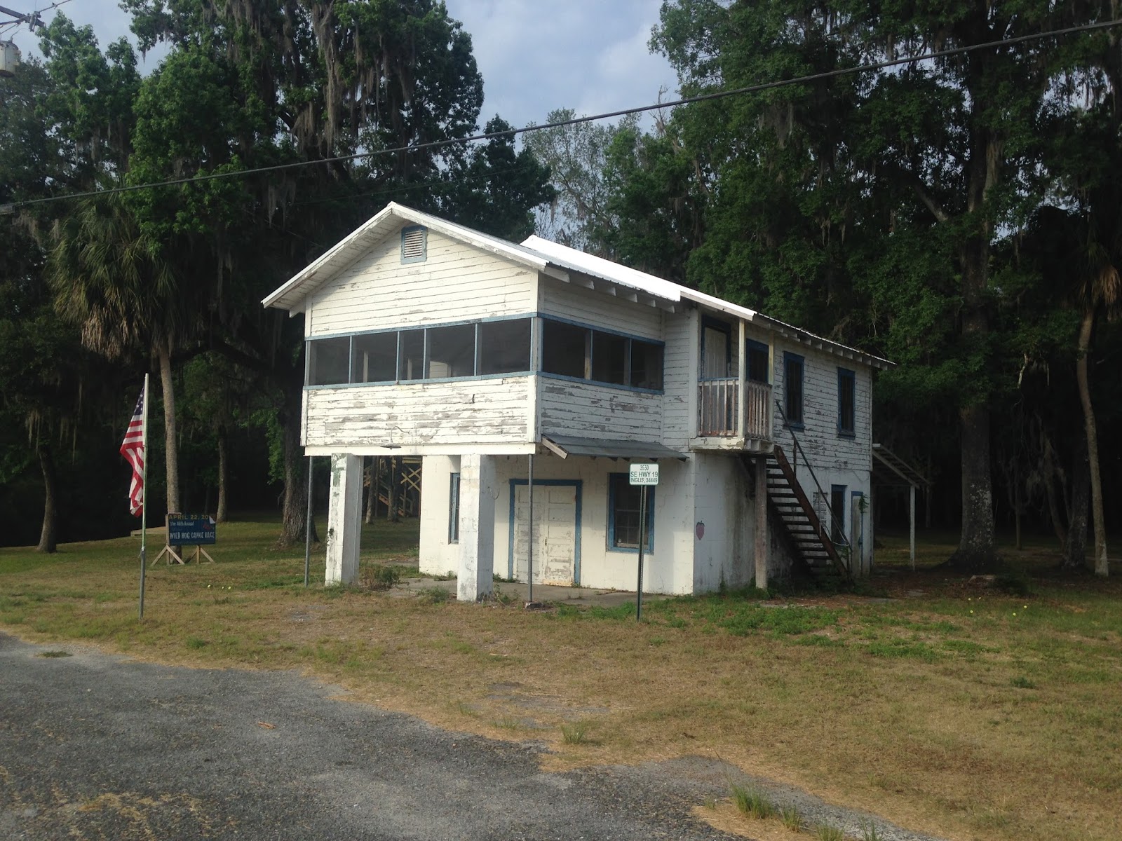
North of Crystal River US 98/19 crosses the Withlacoochee River and enters Levy County. US 98/19 junctions CR 40 in Inglis which used to be part of FL 40.


Much of US 98/19 in Levy County is extremely rural. The speed limit for the most part is 65 MPH and it is a solid alternate route to I-75. The first major junction north of Inglis is FL 121 which is a multi-state route north through Georgia and South Carolina.

North of FL 121 the next major community is Chiefland which is 26 miles away.

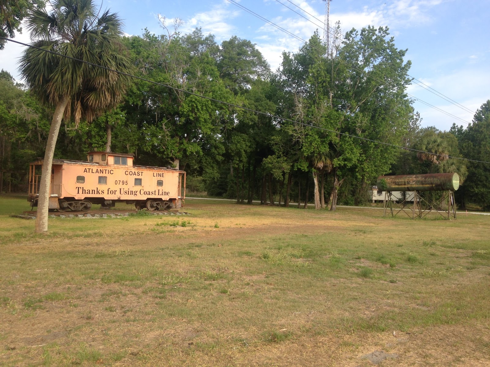
There is a couple ghost towns on US 98/19 in Levy County, the first is Gulf Hammock. The Atlantic Coast Line ran a spur along US 19/98 which I believe was abandoned in the 1950s? Gulf Hammock was apparently a rail siding and never had much significance other than it has buildings that are easily observed on the side of US 98/19. The northbound lanes of US 98/19 offer some decent looks at the old rail grade and bridge work.


At the junction of US 98/19 and FL 24 is the city of Otter Creek.


Otter Creek was a lumber town and during the 1930s was the second largest city in Levy County. Much of Otter Creek is abandoned and I believe the "city" only has about 130 residents left. There are some particularly nice older structures on Southwest 3rd Street. Considering FL 24 runs west to Cedar Key there is actually a lot of old Florida to see from Otter Creek towards the Gulf Coast.


Entering Chiefland US 98/19 junctions the short FL 345.

There are several significant junctions in Chiefland. US 98/19 first picks up US 27A and junctions the southern terminus of US 129 about a block north.


The triple multiplex of US 98/19/27A even junctions FL 320 in the northern reaches of Chiefland. FL 320 is an access road to Manatee Springs State Park.

In Fanning Springs US 98/19/27A actually has a commercial agriculture station south of the junction with FL 26.


US 98/19/27A briefly enters Gilchrist County then crosses the Suwannee River into Dixie County.


The first major junction in Dixie County is FL 349 in Old Town. I'm not sure why the community is called "Old Town" but I do know it does have several buildings from the 1890s.

The only significant community in Dixie County that US 98/19/27A traverses is Cross City. Despite having less than 2,000 residents Cross City is the County Seat of Dixie County.

US 98/19/27A crosses the Steinhatchee River and junctions FL 51 entering Taylor County.


Entering Perry I found this sign assembly at a gas station showing the multiplex of US 98/19/27A. Something like this would never be possible in California, I don't believe there are actually any triple multiplexes left off the top of my head.

Perry is the County Seat of Taylor County and has several significant junctions starting with the southern terminus of US 221.

The mainline US 27 junction is at Hampton Springs Avenue. US 19/27 continue north while I took a westward turn on Hampton Springs Avenue to stay on US 98.

Much of US 98 west of Perry is a two-lane highway. I cut off of US 98 briefly onto CR 359 to visit the ruins of the Hampton Springs Hotel. The Hampton Springs Hotel was built in the early 20th century and burned down in 1954.


US 98 continues westward and crosses the Aucilla River.

US 98 junctions FL 59 and enters Wakulla County.


There are two significant junctions next westward on US 98 with FL 267 and FL 363. Panama City is still 122 miles to the west.


West of FL 363 there is a crossing of the Wakulla River on US 98.

Near Medart US 98 junctions US 319 and briefly multiplexes it. US 319 stays inland while US 98 sticks to the Gulf Coast.


This particular section of US 98 is part of the Big Bend Scenic Byway. US 98 crosses the Ocklockonee Bay Bridge into Franklin County.


US 98 rejoins US 319 and multiplexes it westward.


There are various CR 30 segments which were obvious former alignments of US 98/319. I took one near Carrabelle to stop for a break on the Gulf, the Florida Scenic Route shields are nice looking in my opinion.


Oddly FL 30 is signed in places on US 98/319 when it should be a silent State Road number.

US 98/319 opens onto the Gulf near the Crooked River Light House. The Crooked River Lighthouse was in use from 1895 to 1995.


Can't beat the views over the water.

The next significant junction on US 98/319 is FL 65. Panama City is 65 miles west of FL 65.


The next significant junction on US 98/319 is on Apalachicola Bay at FL 300. I took FL 300 south to St. George Island via the new St. George Island Bridge. The new bridge is part of FL 300 and was opened in 2004 when the old bridge was replaced. The new St. George Island Bridge is 4.1 miles long and largely resembles (at least I think so) Seven Mile Bridge on US 1 in the Florida Keys. The previous bridge was opened in 1965, prior to that time ferry service was the only way to access St. George Island by car. Originally FL 300 was signed as FL G1A much akin to FL A1A, I'm unsure when it changed to the modern designation.


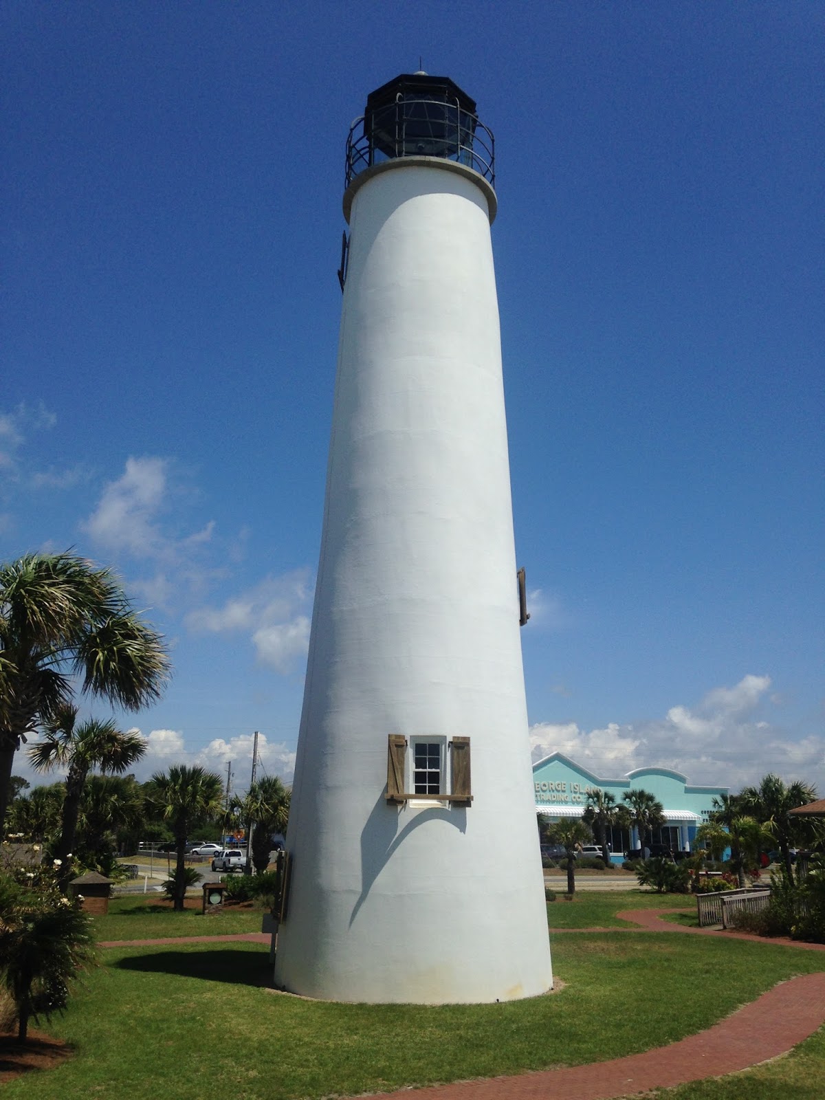
St. George Island is a island directly off the coast of the Florida Panhandle. I stopped in at the St. George Island Lighthouse. The current lighthouse was built in 1852 and replaced the original 1833 light which was damaged in hurricanes.


Returning to US 98/319 I Apalachicola Bay via the John Gorrie Memorial Bridge.


The south terminus of US 319 is in the middle of Apalachicola Bay. The modern bridge has been in place since 1988 which replaced the original span which opened in 1935. Prior to the bridge being opened both US 98 and US 319 advance towards a ferry which carried traffic from Eastport over Apalachicola Bay to the town of Apalachicola. Neither US 98 or 319 is an original 1926 route since both were created in 1933. For whatever reason US 319 has always multiplexed US 98 south to Apalachicola Bay where it used to terminate at the ferry. This has led to the oddity where US 319 now dead ends in the middle of an active highway route. Originally US 98 would have terminated at Apalachicola Bay as it only ran from Pensacola until 1952 when it was extended east Palm Beach.

US 98 is still a surface road in downtown Apalachicola using Market Street and Avenue E.


West of Apalachicola US 98 enters Gulf County and Port St. Joe at CR 30A which is the County Seat.

It seems the opposite side of 30A is state maintained still.

US 98 junctions FL 71 in down Port St. Joe.

I stopped at the George G Tapper Bridge for a break over the Gulf Intercoastal Waterway. I thought the old Army Corps of Engineers sign was a nice find. Incidentally I kept stopping because my left leg was flaring up, I was getting over an Achille's Tendon injury and it really helped to run/walk short distances.

US 98 enters Bay County and the base limits of Tyndall Air Force Base.

After crossing through Tyndall AFB US 98 crosses East Bay on the Dupont Bridge into Panama City.


US 98 has a Business Loop in Panama City.

I thought the "Pawn 98" was actually somewhat fitting given it used a proper US Route shield just south of the junction with FL 22. Pensacola was well over 100 miles away but thankfully my destination was in Fort Walton Beach.


Supposedly a lot of the Panhandle Counties ran out of route numbers hence why some Bay County routes have quadruple digits. Traffic was heavy on US 98 west from Panama City the rest of the way to Fort Walton Beach.

There are several significant junctions on US 98 in Panama City such as; FL 389, FL 77, US 231, FL 390, and FL 368.


US 98 crosses the Grand Lagoon to Panama City Beach. Oddly FL 30 splits along the coast and I'm not sure what the unsigned designation is for US 98.


US 98 junctions FL 79 in Panama City Beach which is signed as "TO" I-10.

Exiting the western extent of Panama City Beach US 98 merges back in with FL 30.


Entering Walton County US 98 kicks back up to a 65 MPH signed expressway configuration. Much of US 98 in Walton County skates the outskirts of Point Washington State Park.

The only significant junction on US 98 in Walton County is the southern terminus of US 331.

Finally I reached Okaloosa County, Fort Walton Beach was only 19 miles ahead. FL 293 is 15 miles in length and actually a tolled. FL 293 utilizes the 3.6 mile Mid-Bay Bridge over Choctawhatchee Bay. I hung onto my Sunpass from when I lived in Florida and took FL 293 to FL 20 when I was leaving Fort Walton Beach. Unfortunately my pictures didn't turn out how I wanted due to it being dark which caused too much blur for my liking.


I did stop in at some old haunts that were near my grand parents house in Destin. Oddly CR 2378 is signed as "Scenic Highway 98" which leads me to believe it might have been an early US 98 alignment.

Henderson Beach State Park was always nice back in the 1980s and 1990s, I was glad to see that developers never got their hands on the land and built up high rises. I haven't been back to the Fort Walton Beach/Destin area since 2013 and I hadn't really explored it since the mid-1990s. I was really surprised how much urbanization had occurred since the 1990s, it was kind of sad to see the small coastal town charm gone.


Surprisingly the old go-kart track in Destin was still around after all these years. My Grand Parents used to take me here as a kid before Henderson Beach. I want to say there was a water ride but all I really recall ever wanting to do was race the go-karts. I want to say the business is now called "Track Destin."

The US 98 bridge west of Destin crossing to Okaloosa Island is used as an make-shift beach. Much of the eastern part of Okaloosa Island is military reserve.

Parts of Okaloosa Island are part of the Gulf Islands National Seashore. The next bridge crossing is where US 98 finally enters Fort Walton Beach.


I did some shield hunting Fort Walton Beach and Mary Esther which included an accidental route clinch of short FL 393. FL 393 is a short north/south route between FL 189 and US 98 on Mary Esther Boulevard/Mary Esther Cut-Off. FL 393 is so insignificant that it currently doesn't even have a Wikipedia page.


I'd have to say after driving all of US 98 between Hernando County and Fort Walton Beach I'm not sure why I dragged my feet on it when I was living in Florida. I-10 might but fast but it probably is one of the most boring stretches of roadway west of I-75 at least to I-110. The next day I would take a northward turn towards the Alabama State Line and beyond.

I took a ton of shield pictures given that I was on US 98 for such a long time. Rather than attempt to post or talk about all the routes, I'll just limit to major junction and link over my US 98 Flickr album:
US 98 between FL 589 and Fort Walton Beach on Flickr
I started the morning somewhat early and made my way up to the north terminus of FL 589 on the Suncoast Parkway and turned onto US 98 west.

US 98 quickly enters Citrus County and approaches US 19 north. Both US 98 and US 19 multiplex to the north to Crystal River on Suncoast Boulevard.


US 98/19 first passes through Homosassa Springs where it junctions County Route 490 and CR 490A. Homosassa Springs is mostly known for the Homosassa Springs State Wildlife Reserve where manatees is easily observed. The village of Homosassa to the west dates back to a sugar plantation from the 1850s.

Entering Crystal River US 98/19 junctions Florida State Road 44. FL 44 is just over 100 miles long and ends at US 441 in Leesburg to the east.

Some obviously older buildings on Citrus Avenue in downtown Crystal River. Crystal River dates back to the 1840s and was settled after the second Seminole War. Crystal River is named after a short river which outlets into the Gulf of Mexico. Crystal River is widely known for the Crystal River 3 Nuclear Power Plant which has had numerous issues the past decade.

North of Crystal River US 98/19 crosses the Withlacoochee River and enters Levy County. US 98/19 junctions CR 40 in Inglis which used to be part of FL 40.


Much of US 98/19 in Levy County is extremely rural. The speed limit for the most part is 65 MPH and it is a solid alternate route to I-75. The first major junction north of Inglis is FL 121 which is a multi-state route north through Georgia and South Carolina.

North of FL 121 the next major community is Chiefland which is 26 miles away.

There is a couple ghost towns on US 98/19 in Levy County, the first is Gulf Hammock. The Atlantic Coast Line ran a spur along US 19/98 which I believe was abandoned in the 1950s? Gulf Hammock was apparently a rail siding and never had much significance other than it has buildings that are easily observed on the side of US 98/19. The northbound lanes of US 98/19 offer some decent looks at the old rail grade and bridge work.

At the junction of US 98/19 and FL 24 is the city of Otter Creek.


Otter Creek was a lumber town and during the 1930s was the second largest city in Levy County. Much of Otter Creek is abandoned and I believe the "city" only has about 130 residents left. There are some particularly nice older structures on Southwest 3rd Street. Considering FL 24 runs west to Cedar Key there is actually a lot of old Florida to see from Otter Creek towards the Gulf Coast.


Entering Chiefland US 98/19 junctions the short FL 345.

There are several significant junctions in Chiefland. US 98/19 first picks up US 27A and junctions the southern terminus of US 129 about a block north.


The triple multiplex of US 98/19/27A even junctions FL 320 in the northern reaches of Chiefland. FL 320 is an access road to Manatee Springs State Park.

In Fanning Springs US 98/19/27A actually has a commercial agriculture station south of the junction with FL 26.


US 98/19/27A briefly enters Gilchrist County then crosses the Suwannee River into Dixie County.


The first major junction in Dixie County is FL 349 in Old Town. I'm not sure why the community is called "Old Town" but I do know it does have several buildings from the 1890s.

The only significant community in Dixie County that US 98/19/27A traverses is Cross City. Despite having less than 2,000 residents Cross City is the County Seat of Dixie County.

US 98/19/27A crosses the Steinhatchee River and junctions FL 51 entering Taylor County.


Entering Perry I found this sign assembly at a gas station showing the multiplex of US 98/19/27A. Something like this would never be possible in California, I don't believe there are actually any triple multiplexes left off the top of my head.

Perry is the County Seat of Taylor County and has several significant junctions starting with the southern terminus of US 221.

The mainline US 27 junction is at Hampton Springs Avenue. US 19/27 continue north while I took a westward turn on Hampton Springs Avenue to stay on US 98.

Much of US 98 west of Perry is a two-lane highway. I cut off of US 98 briefly onto CR 359 to visit the ruins of the Hampton Springs Hotel. The Hampton Springs Hotel was built in the early 20th century and burned down in 1954.


US 98 continues westward and crosses the Aucilla River.

US 98 junctions FL 59 and enters Wakulla County.


There are two significant junctions next westward on US 98 with FL 267 and FL 363. Panama City is still 122 miles to the west.


West of FL 363 there is a crossing of the Wakulla River on US 98.

Near Medart US 98 junctions US 319 and briefly multiplexes it. US 319 stays inland while US 98 sticks to the Gulf Coast.


This particular section of US 98 is part of the Big Bend Scenic Byway. US 98 crosses the Ocklockonee Bay Bridge into Franklin County.


US 98 rejoins US 319 and multiplexes it westward.


There are various CR 30 segments which were obvious former alignments of US 98/319. I took one near Carrabelle to stop for a break on the Gulf, the Florida Scenic Route shields are nice looking in my opinion.


Oddly FL 30 is signed in places on US 98/319 when it should be a silent State Road number.

US 98/319 opens onto the Gulf near the Crooked River Light House. The Crooked River Lighthouse was in use from 1895 to 1995.


Can't beat the views over the water.

The next significant junction on US 98/319 is FL 65. Panama City is 65 miles west of FL 65.


The next significant junction on US 98/319 is on Apalachicola Bay at FL 300. I took FL 300 south to St. George Island via the new St. George Island Bridge. The new bridge is part of FL 300 and was opened in 2004 when the old bridge was replaced. The new St. George Island Bridge is 4.1 miles long and largely resembles (at least I think so) Seven Mile Bridge on US 1 in the Florida Keys. The previous bridge was opened in 1965, prior to that time ferry service was the only way to access St. George Island by car. Originally FL 300 was signed as FL G1A much akin to FL A1A, I'm unsure when it changed to the modern designation.


St. George Island is a island directly off the coast of the Florida Panhandle. I stopped in at the St. George Island Lighthouse. The current lighthouse was built in 1852 and replaced the original 1833 light which was damaged in hurricanes.


Returning to US 98/319 I Apalachicola Bay via the John Gorrie Memorial Bridge.


The south terminus of US 319 is in the middle of Apalachicola Bay. The modern bridge has been in place since 1988 which replaced the original span which opened in 1935. Prior to the bridge being opened both US 98 and US 319 advance towards a ferry which carried traffic from Eastport over Apalachicola Bay to the town of Apalachicola. Neither US 98 or 319 is an original 1926 route since both were created in 1933. For whatever reason US 319 has always multiplexed US 98 south to Apalachicola Bay where it used to terminate at the ferry. This has led to the oddity where US 319 now dead ends in the middle of an active highway route. Originally US 98 would have terminated at Apalachicola Bay as it only ran from Pensacola until 1952 when it was extended east Palm Beach.

US 98 is still a surface road in downtown Apalachicola using Market Street and Avenue E.


West of Apalachicola US 98 enters Gulf County and Port St. Joe at CR 30A which is the County Seat.

It seems the opposite side of 30A is state maintained still.

US 98 junctions FL 71 in down Port St. Joe.

I stopped at the George G Tapper Bridge for a break over the Gulf Intercoastal Waterway. I thought the old Army Corps of Engineers sign was a nice find. Incidentally I kept stopping because my left leg was flaring up, I was getting over an Achille's Tendon injury and it really helped to run/walk short distances.

US 98 enters Bay County and the base limits of Tyndall Air Force Base.

After crossing through Tyndall AFB US 98 crosses East Bay on the Dupont Bridge into Panama City.


US 98 has a Business Loop in Panama City.

I thought the "Pawn 98" was actually somewhat fitting given it used a proper US Route shield just south of the junction with FL 22. Pensacola was well over 100 miles away but thankfully my destination was in Fort Walton Beach.


Supposedly a lot of the Panhandle Counties ran out of route numbers hence why some Bay County routes have quadruple digits. Traffic was heavy on US 98 west from Panama City the rest of the way to Fort Walton Beach.

There are several significant junctions on US 98 in Panama City such as; FL 389, FL 77, US 231, FL 390, and FL 368.


US 98 crosses the Grand Lagoon to Panama City Beach. Oddly FL 30 splits along the coast and I'm not sure what the unsigned designation is for US 98.


US 98 junctions FL 79 in Panama City Beach which is signed as "TO" I-10.

Exiting the western extent of Panama City Beach US 98 merges back in with FL 30.


Entering Walton County US 98 kicks back up to a 65 MPH signed expressway configuration. Much of US 98 in Walton County skates the outskirts of Point Washington State Park.

The only significant junction on US 98 in Walton County is the southern terminus of US 331.

Finally I reached Okaloosa County, Fort Walton Beach was only 19 miles ahead. FL 293 is 15 miles in length and actually a tolled. FL 293 utilizes the 3.6 mile Mid-Bay Bridge over Choctawhatchee Bay. I hung onto my Sunpass from when I lived in Florida and took FL 293 to FL 20 when I was leaving Fort Walton Beach. Unfortunately my pictures didn't turn out how I wanted due to it being dark which caused too much blur for my liking.


I did stop in at some old haunts that were near my grand parents house in Destin. Oddly CR 2378 is signed as "Scenic Highway 98" which leads me to believe it might have been an early US 98 alignment.

Henderson Beach State Park was always nice back in the 1980s and 1990s, I was glad to see that developers never got their hands on the land and built up high rises. I haven't been back to the Fort Walton Beach/Destin area since 2013 and I hadn't really explored it since the mid-1990s. I was really surprised how much urbanization had occurred since the 1990s, it was kind of sad to see the small coastal town charm gone.


Surprisingly the old go-kart track in Destin was still around after all these years. My Grand Parents used to take me here as a kid before Henderson Beach. I want to say there was a water ride but all I really recall ever wanting to do was race the go-karts. I want to say the business is now called "Track Destin."

The US 98 bridge west of Destin crossing to Okaloosa Island is used as an make-shift beach. Much of the eastern part of Okaloosa Island is military reserve.

Parts of Okaloosa Island are part of the Gulf Islands National Seashore. The next bridge crossing is where US 98 finally enters Fort Walton Beach.


I did some shield hunting Fort Walton Beach and Mary Esther which included an accidental route clinch of short FL 393. FL 393 is a short north/south route between FL 189 and US 98 on Mary Esther Boulevard/Mary Esther Cut-Off. FL 393 is so insignificant that it currently doesn't even have a Wikipedia page.


I'd have to say after driving all of US 98 between Hernando County and Fort Walton Beach I'm not sure why I dragged my feet on it when I was living in Florida. I-10 might but fast but it probably is one of the most boring stretches of roadway west of I-75 at least to I-110. The next day I would take a northward turn towards the Alabama State Line and beyond.
Comments