California State Route 15 is an approximately 6.13-mile portion of the Archie Moore Memorial Freeway and Escondido Freeway in the city of San Diego. California State Route 15 beings at Interstate 5 and ends at Interstate 8. California State Route 15 functionally acts as an extension of Interstate 15 south of Interstate 8 to Interstate 5. California State Route 15 exists due to the Archie Moore Memorial Freeway south of Interstate 805 not fully meeting Interstate standards. California State Route 15 was created during 1969 as a renumbering of the original California State Route 103. During 1984 California State Route 15 was approved by the Federal Highway Administration to become a non-chargeable part of Interstate 15 once it meets Interstate design standards.
Part 1; the general history of the original California State Route 15
The current California State Route 15 is the second time the designation has been used. The original California State Route 15 was tied heavily to Legislative Route Number 167 (LRN 167) and the future corridor of the Long Beach Freeway. As originally defined in 1933 LRN 167 ended at LRN 26 (then US Route 60 and later also US Route 99-70) in Monterey Park. The initial run of Sign State Routes was announced in the August 1934 California Highways & Public Works. California State Route 15 was defined as following LRN 167 to a terminus US Routes 99-60-70/LRN 26 in Monterey Park via Atlantic Boulevard (later Atlantic Avenue).
1949 Legislative Chapter 1467 extended the definition of LRN 167 north from US Routes 99-60-70/LRN 26 in Monterey Park to US Route 66/LRN 205 at the Arroyo Seco Parkway. The extended definition of LRN 167 appears on the 1950 Division of Highways Map as a planned highway between US Routes 99-60-70/LRN 26 in Monterey Park and US Route 66/LRN 205 in South Pasadena. It is unclear if the original California State Route 15 was intended to also be extended.
The May/June 1951 California Highways & Public Works announced the planned Los Angeles River Freeway grade of California State Route 15/LRN 167 had been renamed the "Long Beach Freeway." The article stub notes the Long Beach Freeway name had been adopted by a Los Angeles County Board of Supervisors resolution. The origins of the Long Beach Freeway are stated to have been conceptualized 14 years prior by the Long Beach City Engineering Department.
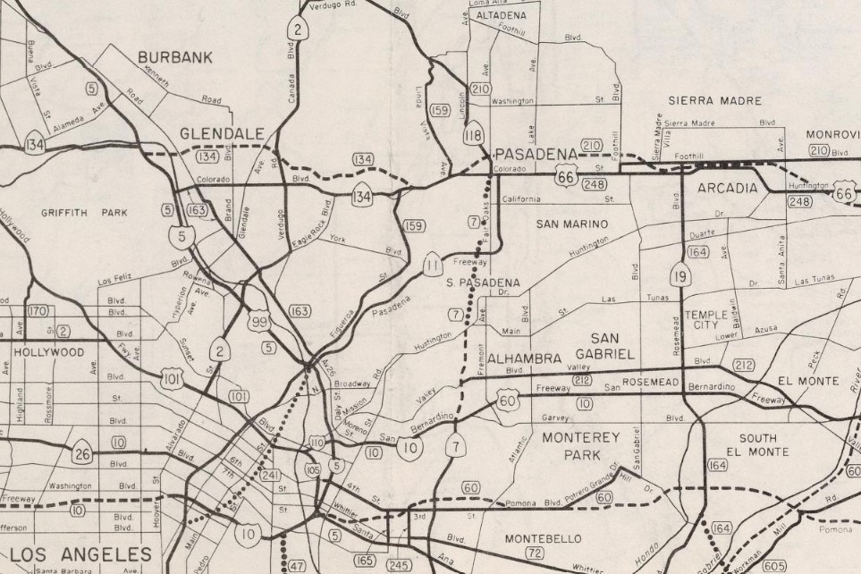
1951 Legislative Chapter 1562 truncated the planned routing of LRN 167 to Huntington Drive in Alhambra. The truncated definition and planned routing of LRN 167 to Huntington Drive appears on the 1952 Division of Highways Map.
The location of the Long Beach Freeway from the Santa Ana Freeway to Huntington Drive was adopted by the California Highway Commission on July 24, 1953. Ultimately 1959 Legislative Chapter 1062 extended the northern terminus of LRN 167 to US Route 66A/California State Route 11/LRN 9 in Pasadena. LRN 167 thusly appears on the 1960 Division of Highways Map as a planned freeway with no adopted routing north of Huntington Drive to US Route 66A/California State Route 11/LRN 9.
The Division of Highways began location studies on the Pasadena extension of LRN 167 and the Long Beach Freeway during 1960. On April 21, 1960, the State formally notified the cities of Pasadena, South Pasadena and Alhambra that studies were being initiated for the location of the Long Beach Freeway from Huntington Drive to the Foothill Freeway. The March/April 1961 California Highways & Public Works notes Senate Bill 480 established a 1.7-mile extension of the Long Beach Freeway from the city of Alhambra to near the junction of the Foothill-Pasadena Freeways. The Long Beach Freeway extension is stated to be under advanced planning along with the north/south leg of the Foothill Freeway through Pasadena.
California State Route 15 was completely shifted to the Long Beach Freeway between the San Diego Freeway and San Bernardino Freeway by 1962. The 1964 California State Highway Renumbering had numerous impacts on the Long Beach Freeway corridor. LRN 167 along with the other Legislative Route Numbers were dropped in favor of field signage. California State Route 15 was replaced with the second iteration of California State Route 7 to make room to avoid duplication with Interstate 15. The 1964 Division of Highways Map displays the second iteration of California State Route 7 as the planned but unadopted routing of the Long Beach Freeway through Pasadena.
Ultimately the Long Beach Freeway and the second California State Route 7 would be reassigned as Interstate 710/California State Route 710. More regarding the history of the Long Beach Freeway can be found in the blog below:
Part 2; the history of the current California State Route 15
The current California State Route 15 originated with the adoption of LRN 283 by way of 1959 Legislative Chapter 1062. The original definition of LRN 283 was as follows:
1. LRN 241 near north city limits of National City to LRN 2 (US Route 101/Interstate 5) 2. LRN 2 to LRN 77 (US Route 395) near United States Naval Air Station, Miramar
The July/August 1960 California Highways & Public Works discussed segment two of LRN 283. LRN 283 is noted in the article to not have a formal route adoption by the California Highway Commission between US Route 101/LRN 2 and US Route 395/LRN 77. The article references the city of San Diego adopting Wabash Boulevard, 40th Street and Ward Road as major highway corridor following World War II. The Wabash Boulevard/California State Route 94 interchange is shown to have been constructed by the city of San Diego prior to becoming part of LRN 283. A portion of Ward Road between Monroe Street to US Route 80 is noted to be nearing completion as a four-lane expressway. The segment north of US Route 80 to US Route 395 is noted to be under construction and financed. Continued development of LRN 283 is noted to be a cooperative between the Division of Highways, city of San Diego and Federal Aid Programs.
The 1962 Division of Highways Map displays LRN 283 completed north from US Route 101/Interstate 5/LRN 2 following Wabash Boulevard, 40th Street and Ward Road.
The November/December 1963 California Highways & Public Works noted Wabash Boulevard was to be resurfaced during the 1964-65 Fiscal Year before being relinquished to back to the city of San Diego. Wasbash Boulevard is noted to have been superseded by the freeway construction of LRN 283.
As part of the wider 1964 State Highway Renumbering segment two of LRN 283 was reassigned as the original California State Route 103. California State Route 103 appears for the first time on the 1964 Division of Highways Map between US Route 101/Interstate 5 and US Route 395.
The January/February 1964 California Highways & Public Works announced the adoption of 6.4 miles of freeway along California State Route 103 near US Route 80/Interstate 8 north to US Route 395. This adoption was made by the California Highway Commission during their late year 1963 meetings. The adopted freeway corridor followed the existing routing of California State Route 103 along Ward Road and Murphy Canyon Road.
An interchange project on California State Route 103 and expressway conversion of the highway north of US Route 80/Interstate 8 was announced as being budgeted for the 1966-67 Fiscal Year in the November/December 1965 California Highways & Public Works.
The November/December 1966 California Highways & Public Works announced construction of an interchange on California State Route 103 at Kearny Villa Road to provide a temporary movement to US Route 395 during the1967-68 Fiscal Year.
Interstate 15 was approved to be extended south of Interstate 10 in San Bernardino to Interstate 8 in San Diego as a chargeable corridor by the Federal Highway Administration during December 1968. The newly extended Interstate 15 was to follow the corridor of California State Route 103 south of US Route 395 to Interstate 8.
1969 Legislative Chapter 292 deleted the first California State Route 103 whereas Legislative Chapter 294 transferred it's routing as part of Route 15. Route 15 between US Route 395 south to Interstate 8 was part of the corridor of future Interstate 15 whereas the corridor south to Interstate 5 became California State Route 15. The original California State Route 103 can still be seen signed on the 1970 Division of Highways Map but legislatively defined as part of Route 15.
Interstate 15 is shown complete to Interstate 8 on the 1975 Caltrans Map. California State Route 15 is shown continuing south to Interstate 5.
The corridor of California State Route 15 and Interstate 15 from Interstate 805 north to California State Route 91 was named the "Escondido Freeway" by way of 1979 Assembly Concurrent Resolution Number 34, Chapter 67. During 1984 the Federal Highway Administration approved the entirety of California State Route 15 to be assigned as non-chargeable Interstate 15 upon the corridor being rebuilt to Interstate standards.
On October 24, 1984, Caltrans submitted a request to the American Association of State Highway Transportation Officials (AASHTO) to extend Interstate 15 from Interstate 8 to Interstate 5 via California State Route 15. Caltrans noted the Federal Highway Administration had already given approval to extend Interstate 15 south to Interstate 5 as a non-chargeable corridor. The request was granted by AASHTO December 8, 1984. AASHTO's approval to extend Interstate 15 did not carry a stipulation that California State Route 15 be upgraded to Interstate standards.
The 1986 Caltrans Map displays California State Route 15 north of Interstate 5 to Interstate 805 as freeway. California State Route 15 north of Interstate 805 to Interstate 8 is displayed as a mix of freeway, conventional highway and expressway.
1999 Concurrent Assembly Resolution Number 90, Chapter 141 renamed California State Route 15 north of Interstate 5 to Interstate 805 as the "Archie Moore Memorial Freeway." Previously this segment of California State Route 15 had been known locally (albeit not officially) as Wabash Boulevard or the Wabash Freeway.
During the early 2000s California State Route 15 north of Interstate 805 to Interstate 8 was fully brought up to freeway standards and largely replaced 40th Street. During 2001 Teralta Park was constructed over California State Route 15 as the corridor was being converted to freeway. Presently California State Route 15 between Interstate 5 and Interstate 805 is ineligible to become Interstate 15 for the following reasons:
- Blind and substandard access ramps.
- A left hand exit from California State Route 15 southbound to Interstate 5 southbound at Exit 1C.
- The narrowing of California State Route 15 to two lanes at the California State Route 94 interchange.
Part 3; RoadwayWiz on California State Route 15
During August 2020 Dan Murphy of RoadwayWiz featured a real-time drive along California State Route 15 southbound from Interstate 8 to Interstate 5.
This past weekend I spent some time in Cajon Pass traversing the many historic road alignments. Cajon Pass is located in San Bernardino County, California along the San Andreas Fault. Cajon Pass serves the boundary line between the Mojave Desert, the San Gabriel Mountains, San Bernardino Mountains and San Bernardino Valley. Cajon Pass is historically one of the most traveled transportation corridors in American California and presently is served by four rail lines, Interstate 15 and California State Route 138. While Cajon Pass is known mostly for carrying US Route 66 it has carried numerous other signed highways that have had a significant impact on regional and national road travel. While this is my best attempt to compile everything from the best sources I could find into one single transportation history blog regarding road travel in Cajon Pass I suspect as time goes on this article will be frequently updated. If you have any information that you ...
Pardee Dam is a 358-foot-high concrete structure located near Campo Seco at the Calaveras County and Amador County Line. Pardee Dam impounds the Mokelumne River which forms the namesake Pardee Reservoir. Pardee Dam was completed during 1929 and is part of the East Bay Municipal Utility District. Pardee Dam is accessed by the namesake Pardee Dam Road which crosses the structure via the one-lane road seen as the blog cover photo. Part 1; the history of Pardee Dam Road The closest community to Pardee Dam is that of Campo Seco on the Calaveras County side of the Mokelumne River. Campo Seco was founded in 1850 by Mexican Miners who worked placer claims in Oregon Gulch during the height of the California Gold Rush. Campo Seco would reach a population of about three hundred by 1860 spurred by the numerous mining claims in the area. Main Street of Campo Seco flowed directly into the Campo Seco Turnpike which had been authorized by the California L...
After completing Interstate 380 I made my way northward into the City Limits of San Francisco to drive the northernmost portion of California State Route 82. CA 82 is 52 mile State Route between I-280 in San Francisco southward to Interstate 880 in San Jose. CA 82 is significant due to it being part of the historical surface alignment of US Route 101 and the El Camino Real. The "El Camino Real" was a Spanish Highway in Las Californias and Alta California which connected the 21 Catholic Missions along the coast. Essentially the route of the El Camino Real was plotted out in the late 1700s from two Spanish survey expeditions. The Missions were plotted approximately 30 miles apart along the 600 mile route so that they would be a single day journey by horse. The El Camino Real name fell into disuse after the Mexican Revolution of 1821 but was revived by American highway promoters in the 1890s and 1900s. Today the El Camino Real is mostly associated...


Comments