US Route 80 was one of the original US Routes which was designated during November 1926. The original definition of US Route 80 had its western terminus located in San Diego, California. US Route 80 originally had a western terminus in downtown San Diego at US Route 101. Rumors have persisted for years in the road-fan community that US Route 80 was once extended to Point Loma before being truncated out of California during 1966. Until now, not much substantial evidence has been found pertaining to the possible extension of US Route 80 to Point Loma.
Featured above is the cover photo of the November/December 1958 California Highways & Public Works which depicts the parking area on Point Loma and Cabrillo National Monument. The cover photo excerpt in the November/December 1958 California Highways & Public Works notes the parking area at end of Legislative Route Number 12 to be the terminus of US Route 80 at Point Loma.
The history of how US Route 80 likely got to Point Loma
Disclaimer: this blog contains far more conjecture than one will normally see in a Gribblenation blog related to a California highway. The above notation of US Route 80 terminating at Point Loma thus far is the only really credible document to overtly state it was ever extended west of US Route 101 in the San Diego area. Much of the remaining evidence is largely circumstantial and consists of indirect references to US Route 80 reaching Point Loma.
The initial draft of the US Route System was approved by the Secretary of Agriculture during November of 1925. The US Route System within California was approved by California Highway Commission with no changes recommended which can be in a document contained in the
January 1926 California Highways & Public Works. US Route 80 is described as terminating at an undisclosed location in San Diego via what was Legislative Route Number 12 (LRN 12) and the Old Spanish Trail.
The US Route System was approved by the American Association of State Highway Officials (AASHO) on November 11, 1926. The designation of the US Route System in California did not confer much more than general corridor routings. The Auto Clubs did not begin to sign the US Routes in California until 1928. Given the State and Division of Highways were not permitted to maintain urban highway mileage until 1933 there was far more discretion by local authorities as to the location of the US Routes in major cities. The timeframe for the signage of US Route 80 in San Diego is unclear, but it is inferred to terminate in downtown to US Route 101/Broadway via 4th Street on the
1930 Division of Highways Map.
On
September 4, 1930, the San Diego city council passed a resolution to petition the California Highway Commission to extend US Route 80 to Point Loma. Specifically, the request was to extend the highway from Horton Plaza to the Old Spanish Lighthouse at Point Loma.
The
October 1931 California Highways & Public Works describes a hearing held by the California Highway Commission in San Diego. During the meeting an advocate for San Diego County expressed a local desire to have US Route 80 extended to Point Loma under the pretense that it would make for a truly coast-to-coast corridor (by then US Route 80 had been extended to Tybee Island in Georgia).
On
December 16, 1931, the San Diego City Council directed the Manager of Operations to survey extension of US Route 80 from Horton Plaza to Point Loma.
On
July 18, 1932, the San Diego City Council passed a second resolution to petition the California Highway Commission to extend US Route 80 to Point Loma.
During 1933 the legislative barriers preventing the Division of Highways from maintaining mileage in cities was removed. This measure led to the adoption of large swathes of urban State Highway mileage. One such addition was the extension of LRN 12 west of US Route 101/LRN 2 to Point Loma:
"Atlantic Street, San Diego to old Spanish Lighthouse, Point Loma"
On
July 7, 1933, the San Diego City Council passed a resolution to reroute US Route 80 north of downtown San Diego to US Route 101. Specifically, the resolution called for US Route 80 to diverge from the original alignment at Park Boulevard and Normal Street. The proposed new alignment would follow Normal Street and University Avenue westerly to Atlantic Street (then US Route 101). The resolution was contingent upon California Highway Commission approval which appears to have never occurred.
The
August 1934 California Highways & Public Works announced the completion of LRN 12 west of US Route 101 to Point Loma and Cabrillo National Monument via a modernized El Camino Cabrillo. The modernized highway carrying LRN 12 to Point Loma is stated to have been dedicated on July 16, 1934, and ended at the Old Spanish Lighthouse parking area. The article makes no mention to an extension of US Route 80.
The
1938 Division of Highways Map displays US Route 80 ending in downtown San Diego via multiplex with US Route 395 on Park Boulevard at US Route 101/Broadway.
Some commercial maps of the era such as the 1940 Gousha Highway Map hosted on usends.com
San Diego endpoint page depict US Route 80 ending at Point Loma. No published Division of Highways Map ever explicitly displayed US Route 80 ending at Point Loma.
US Route 101 is depicted on the
1944 Division of Highways Map as being realigned through downtown San Diego via Harbor Drive. US Route 80 (multiplexed with US Route 395) is depicted as being extended through downtown San Diego via Market Street to US Route 101.
Following the completion of the Cabrillo Freeway through Balboa Park US Route 80 and US Route 395 were shifted onto a new alignment entering downtown San Diego via 11th Street. The shift onto the Cabrillo Freeway did not affect the terminus of US Route 80 being located at US Route 101/Harbor Drive. The new alignment of US Route 80 and US Route 395 through Balboa Park on the Cabrillo Freeway can be seen on the
1948 Division of Highways Map.
Camino Del Real between US Route 395/LRN 77 and US Route 101/LRN 2 was taken under state maintenance as part of LRN 12 during 1953 and appears on the
1954 Division of Highways Map.
The
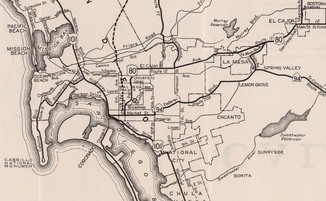
1955 Division of Highways Map depicts the new US Route 80 bypass freeways of El Cajon and La Mesa connecting to US Route 101 via Camino Del Rio. The map does not depict if US Route 80 was realigned directly to US Route 101 or Point Loma.
The
July/August 1955 California Highways & Public Works refers to Rosecrans Boulevard/LRN 12 between Lytton Street and Pacific Highway as part of US Route 80. This is the first known instance of US Route 80 being referenced as existing west of US Route 101 towards Point Loma.
As noted in the intro, the November/December 1958 California Highways & Public Works specifically states US Route 80 ended at the Old Spanish Lighthouse at Point Loma. There is no instance of a documented request by the California Division of Highways to the AASHO to extend or realign US Route 80. It is likely such a request was not necessary given the movement of US Route 80 was entirely contained to San Diego and did not require a redefinition of the highway.
The
May/June 1961 California Highways & Public Works describes the freeway corridor of US Route 80 as ending at US Route 101. The actual endpoint of US Route 80 is not clearly conveyed in the article.
The 1964 California Highway Renumbering reclassified LRN 12 west of US Route 101 as part of
California State Route 209. The
1964 Division of Highways Map depicts California State Route 209 as ending at Point Loma but does not clearly convey the status of US Route 80 beyond US Route 101.
On November 27, 1966, the AASHO approved a request by the Division of Highways to truncate US Route 80 to the Arizona State Line. The rationale behind the truncation of US Route 80 was that it was almost completely multiplexed with Interstate 8 east of Interstate 5. The attached Division of Highways Map depicts US Route 80 terminating at Point Loma. Oddly whoever drew the map of US Route 80 had accidentally applied it over California State Route 94 east of San Diego. This is the only known instance of US Route 80 being referred to as ending at Point Loma contained in the AASHTO Database.


With all the evidence presented above is it conclusive that US Route 80 ended at Point Loma? The direct reference to US Route 80 ending at Point Loma on the cover the November/December 1958 California Highways & Public Works suggests the highway was actually extended there. However, the lack of actual published Division of Highways Maps coupled with a lack of photos of US Route 80 west of US Route 101 is a problem. Actual photographic proof of US Route 80 at Point Loma or some other substantial Division of Highways document likely will be needed to make a conclusive confirmation.


Comments