
I-280 as a freeway spans 59 miles from US 101/I-680 in San Jose northeast to King Street in San Francisco. I-280 serves largely as a bypass route of most of the major cities around the San Francisco Peninsula and an alternate to US 101 on the Bayshore Freeway. Daily traffic counts on I-280 range from 11,000 vehicles to over 200,000.
CAhighways.org on I-280
Much of the finalized planning of the Interstate Highway System in the San Francisco Bay Area was largely plotted out by 1956. Between CA 17 in Los Gatos and CA 1 in San Francisco the path of I-280 ultimately followed Legislative Route Number 239 which was designated by the State Legislature in 1957.
CAhighways.org on LRN 239
LRN 239 can be seen appearing on the State Highway Map City Insert of San Francisco connecting to CA 1 by 1958.
1958 State Highway Map City Insert
I-280 was to take a far different route than it currently does in San Francisco. The original plan for I-280 was to follow CA 1 on LRN 56 towards the Golden Gate Bridge where it would terminate at I-480/LRN 224 and US 101. The original planned alignment of I-280 becomes apparent on State Highway Maps after the 1964 State Highway Renumbering when legislative definitions were changed to match the route number or planned route number. This can be seen by comparing the 1963 State Highway Map City Insert compared to the 1964 edition.
1963 State Highway Map City Insert
1964 State Highway Map City Insert
In 1968 the planned alignment of I-280 was officially moved off of CA 1 onto the planned CA 87 (former LRN 253) connection to the Embarcadero Freeway (I-480/CA 480) underneath the western approach of the Bay Bridge where it would have connected to I-80. Subsequently the planned connection of I-80 west of US 101 was redesignated as CA 241. The new alignment of I-280 absorbed much of what was CA 82 in San Francisco (former LRN 2).
CAhighways.org on I-280
CAhighways.org on CA 241
The changes described above can be seen on the 1969 State Highway Map along with I-480 becoming CA 480. I-280 appears to have been built north towards 18th Street by 1969.
1969 State Highway Map City Insert
Ultimately I-280 would reach a north terminus at Brannan Street at some point in the 1970s which can be seen on the 1975 State Highway Map.
1975 State Highway Map City Insert
The connection to of I-280 to I-80 or for that I-280 was never complete. The City of San Francisco apparently asked the state to stop construction of the connection to CA 480 in 1969. By 1973 according to Kurumi.com I-280 had been built on an elevated freeway segment that reached 3rd Street but would go no further towards I-80.
Kurumi.com on I-280
Following the 1989 Loma Prieta Earthquake the Embarcadero Freeway was heavily damaged. Subsequently the connection of I-280 to I-80 was abandoned by Caltrans in 1990. The Embarcadero Freeway was demolished in 1991 which served to ensure the planned 1968 terminus of I-280 would never be completed as planned. During the 1990s a new north terminus of I-280 was built to the corner of King Street and 5th Street where it presently ends.
My approach to I-280 north began from US 101 north in San Jose in Santa Clara County. Interestingly CA 130 is still signed on US 101 north approaching the I-280/I-680 interchange.


Downtown San Jose can be observed from the flyover ramp connecting US 101 north to I-280 north.


I-280 north has various important exits signed immediately in San Jose.

Traffic on I-280 north headed to San Jose International Airport is directed to use CA 87.

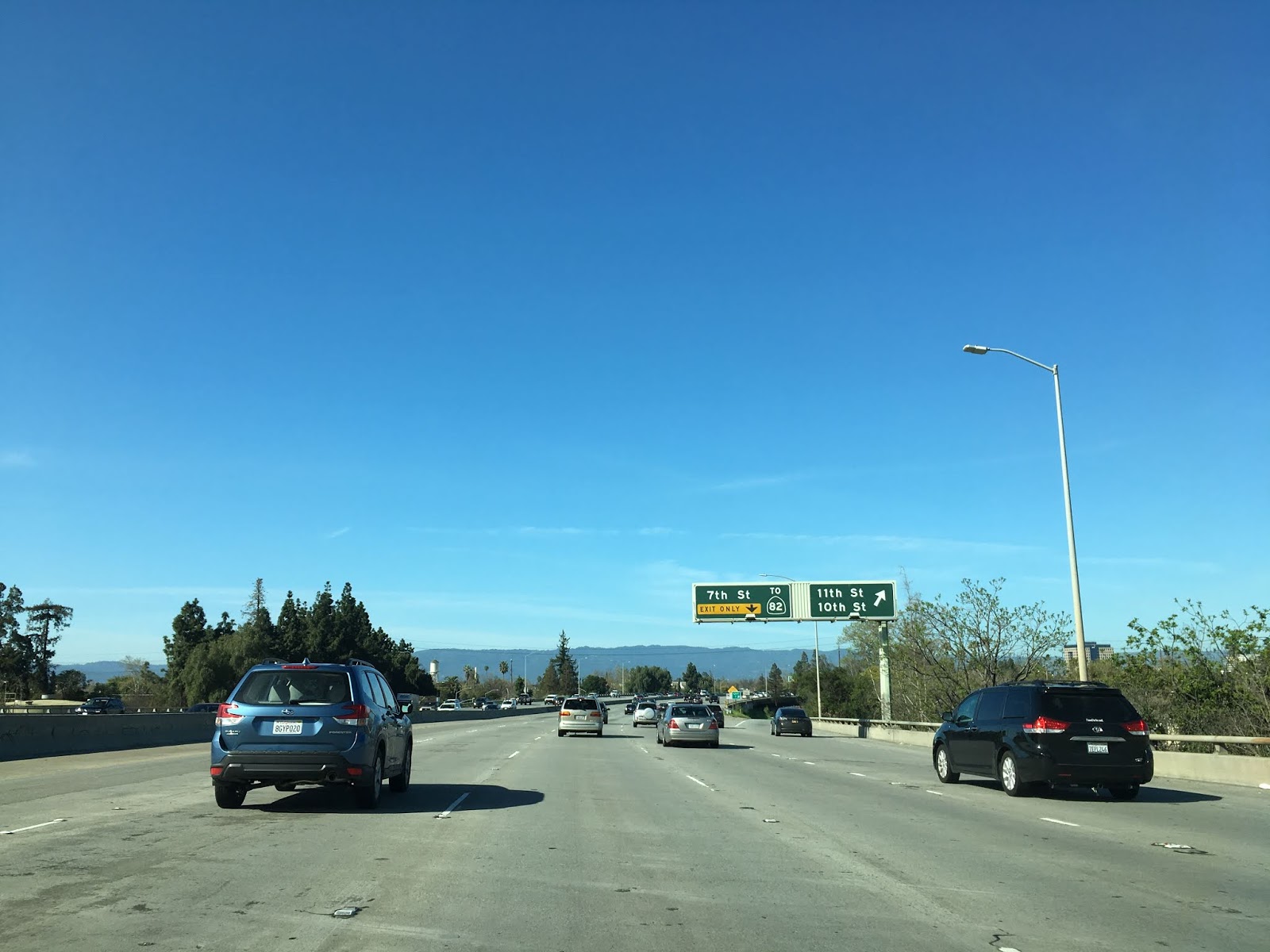
CA 82 traffic is directed to exit I-280 north at 7th Street.

I-280 north meets CA 87/Guadalupe Parkway in downtown San Jose.


Since the northern segment of I-280 was originally planned as part of CA 87 the history of said route can be found on the blog below:
California State Route 87
I-280 north of CA 87 meets Signed County Route G8 on the Almaden Expressway.


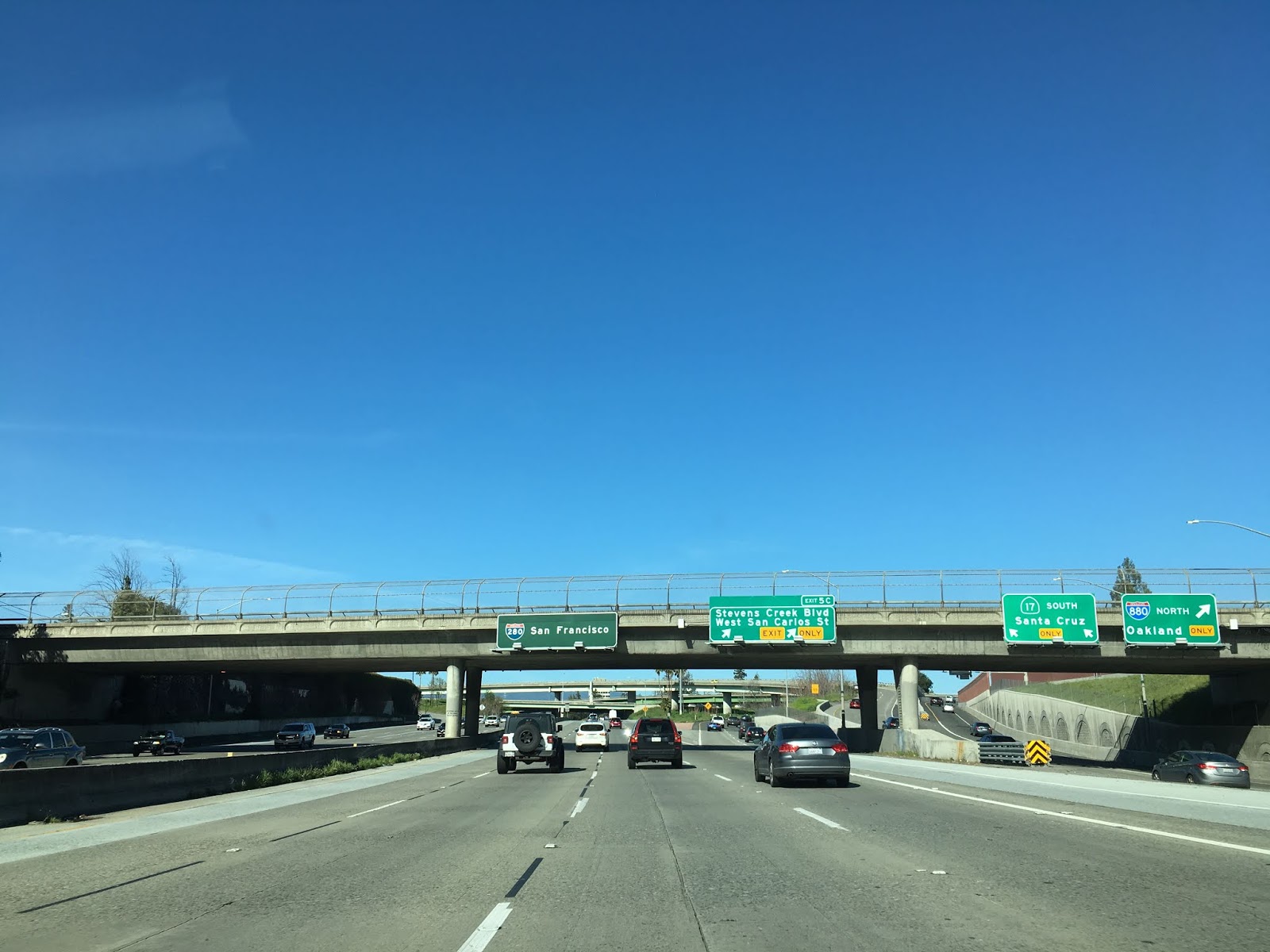
As I-280 north continues through western San Jose it has a junction with CA 17 south and I-880 north.

As I-280 north crosses over CR G2 on San Thomas Expressway. The closest access to G2 is via Exit 7 on Saratoga Road. It should be noted that Exit signage on I-280 is sparsely numbered in places.


At Exit 9A in western San Jose I-280 north meets CR G2 on Lawrence Expressway.

I-280 north enters Cupertino and meets CA 85 at Exit 12A and Exit 12B.


I-280 north of CA 85 is signed as being 10 miles from the next services. At Exit 13 I-280 north meets CR G5 on Foothill Expressway.


At Page Mill Road I-280 meets CR G3 on Page Mill Road. Access to Mountain View is signed via G3 north.

North of Page Mill Road/G3 the route of I-280 north begins the follow the San Andreas Fault and foot hills of the Santa Clara Mountains. CA 84 is signed as 6 miles away in Woodside whereas CA 92 is signed as 13 miles away. At Alpine Road I-280 north enters San Mateo County.


At Exit 25 I-280 north meets CA 84 in Woodside.


North of CA 84 the route of I-280 is signed with scenic placards. CA 92 is signed as 6 1/2 miles from CA 84 on I-280 north. I-280 north meets CA 92 at Exit 33.


North of CA 92 the route of I-280 is signed 22 miles from San Francisco.

At Exit 34 on Bunker Hill Drive I-280 north picks up CA 35 north. The first I-280 north/CA 35 north reassurance signage can be seen approaching Exit 36.


North of Exit 36 the route of I-280 has a freeway rest area.


As I-280 north enters San Bruno CA 35 north splits away onto Skyline Boulevard via Exit 41. San Francisco is signed 15 miles away on I-280 north at Skyline Boulevard.


I-280 north meets I-380 at Exit 43B in San Bruno. I-380 is signed as direct access to San Francisco International Airport.


I-280 north enters Daly City and picks up CA 1 north near Southgate Avenue. I-280 north/CA 1 north multiplex briefly in Daly City to Exit 49B at 19th Avenue. As noted above the path of I-280 north was originally intended to follow CA 1 on 19th Avenue to the Golden Gate Bridge.


Before continuing on I-280 north I pulled off on Exit 49A onto John Daly Boulevard and headed to Reservoir Hill. Reservoir Hill at 780 feet above sea level is the highest point in Daly City and overlooks I-280 heading northward into San Francisco. The initial alignment of US 101 on Mission Street can be seen to the east of I-280 from Reservoir Hill.


Continuing north on I-280.CA 1 the freeway enters San Francisco at 19th Avenue where CA 1 splits towards the Golden Gate Bridge.


I-280 north continues through San Franscisco before meeting US 101 at Exit 54A and Exit 54B.


North of US 101 access to Oracle Park and a California Welcome Center is signed from Exit 56 at Mariposa Street on I-280. Oracle Park is still signed as AT&T Park from I-280.


I-280 north traffic to King Street and the Embarcadero is directed to use the two most left lanes approaching the freeway terminus.

Prior to the King Street terminus I-280 north traffic would empty onto Sixth Street at Brannan Street.


I-280 north continues to it's terminus point at King Street/5th Street. The view of downtown San Francisco is one of the best in the entire Interstate system in my opinion.


I-80/US 101 traffic along King Street is directed to take 3rd Street in front of Oracle Park. King Street becomes the Embarcadero east of Oracle Park.

Comments