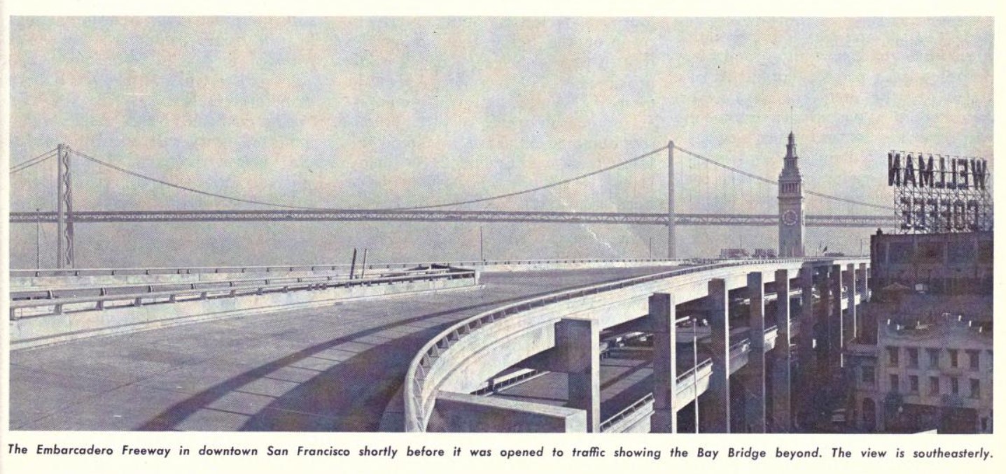
The Embarcadero in the City of San Francisco is a historic waterfront road corridor along San Francisco Bay. Most likely know of the Embarcadero from the former double deck Embarcadero Freeway which once served as Interstate 480 and later California State Route 480. The Embarcadero Freeway was completed from Interstate 80 to Broadway by 1959 and generally came to be seen as a blight on the San Francisco Bay waterfront. The demise of Embarcadero Freeway' would eventually come largely at the hand of the Loma Prieta Earthquake which rendered it unstable. The Embarcadero Freeway was part of a larger plan to connect a fully limited access freeway through San Francisco to the Golden Gate Bridge. California Division of Highways plans would have seen Interstate 480 continue from the end of the Embarcadero Freeway to the Golden Gate Bridge as the so-called Golden Gate Freeway. In this blog we will examine the history of the Embarcadero, Embarcadero Freeway and planned Golden Gate Freeway. Featured as the blog cover photo is the Embarcadero Freeway facing the San Francisco-Oakland Bay Bridge in early 1959 shortly before it was extended to Broadway.
Part 1; the history of the Embarcadero, Embarcadero Freeway and Golden Gate Freeway
The Embarcadero is a waterfront roadway which is plotted along San Francisco Bay in downtown San Francisco. The Embarcadero directly translated from Spanish into English means "Place to Embark" and is lined with waterfront piers. The Embarcadero stretches from King Street north/northwest around San Francisco Bay to Pier 45 near Jefferson Street.
Much of the Embarcadero was constructed along a sea wall which was plotted in the 1860s but was not completed until the 1920s. The 1857 Coast Guard Survey Map of San Francisco shows the original shoreline between Telegraph Hill and Rincon Point. Yerba Buena Cove is shown as already partially filled.
Street.
Prior to the completion of the San Francisco-Oakland Bay Bridge the Ferry Terminal Building at Embarcadero and Market Street was the primary means of direct transportation from San Francisco to Oakland. The Ferry Terminal building was completed in 1898 and withstood the 1906 San Francisco Earthquake relatively undamaged. The Ferry Terminal Building would serve as the landing site of the early Lincoln Highway beginning in 1913. As originally plotted the Lincoln Highway briefly followed the Embarcadero from the Ferry Terminal Building to Market Street.
1947 Chapter 11 defined what would become the basis for the Embarcadero Freeway in the form of
Legislative Route Number 224 (LRN 224). The original definition of LRN 224 was as follows:
"LRN 2 (US Route 101) near the intersection of Lombard Street and Van Ness Avenue to the Bay Bridge approach in San Francisco."
LRN 224 and the projected path of the Embarcadero Freeway first appear on the
1948 Division of Highways Map. The projected path of the Embarcadero Freeway is shown follow the general corridor of Lombard Street through Russian Hill.
The
November/December 1953 California Highways & Public Works announced grading and paving on the first unit of the Embarcadero Freeway was budgeted for the 1954-55 Fiscal Year. The first unit of the Embarcadero Freeway is stated to have been located between Broadway and Fourth Street.
The
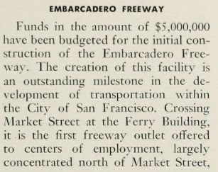
March/April 1954 California Highways & Public Works notes $5,000,000 dollars had been allocated for the initial construction of the Embarcadero Freeway. The article stub also outlines the general double deck alignment of the Embarcadero Freeway through San Francisco along with ramp locations.
The
July/August 1954 California Highways & Public Works provides a status update to the first construction contract on the Embarcadero Freeway. The article stub notes the long-term goal of the Embarcadero Freeway was to have the corridor reach the Golden Gate Bridge.
The
March/April 1955 California Highways & Public Works announced a contract to construct the first unit of the Embarcadero Freeway had been awarded during March. The article stub notes $2,600,000 dollars had been budgeted for the 1955-56 Fiscal Year for construction of the second unit of the Embarcadero Freeway.
The
September/October 1955 California Highways & Public Works features an article citing the freeway recommendations made by the San Francisco Chamber of Commerce. The Embarcadero Freeway is noted to be one of the freeways recommended by the San Francisco Chamber of Commerce in a report submitted to the Division of Highways on August 17, 1955.
The planned Embarcadero Freeway and general conceptual corridor of the Golden Gate Freeway both appear on a 1955 map of planned Interstates around San Francisco Bay.
The
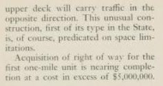
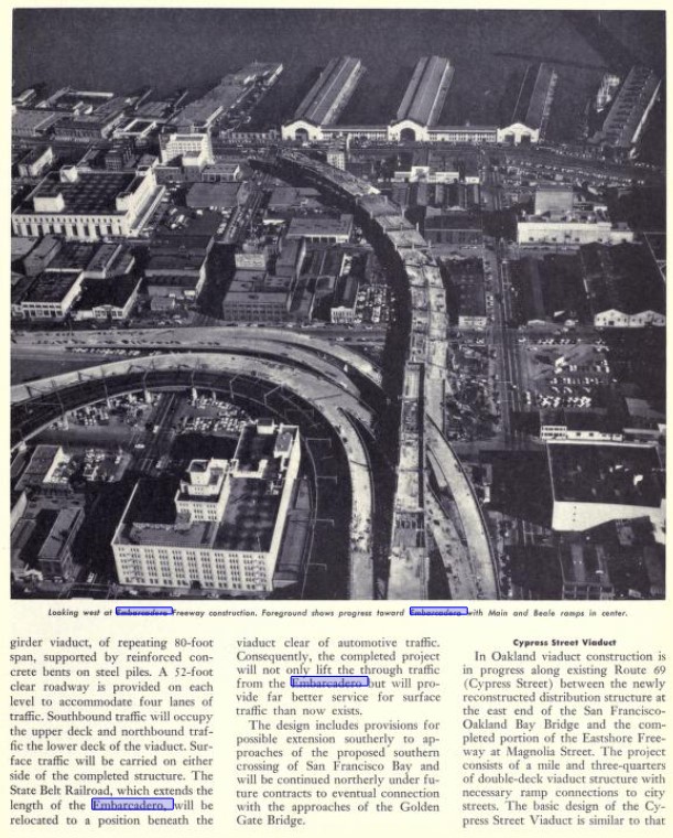
March/April 1956 California Highways & Public Works noted construction of the Embarcadero Freeway began during May 1955. The article stub notes the Embarcadero Freeway would in the future connect with the planned Golden Gate Freeway and Central Freeway. An attached map depicts the Golden Gate Freeway as not having a selected project corridor. An attached series of photos shows the first stages of construction on the Embarcadero Freeway.
On June 29, 1956, the Federal Highway Aid Act of 1956 was signed into law on the Federal Level. The Federal Highway Aid Act of 1956 was the genesis point of the Interstate Highway System. The Embarcadero Freeway and conceptual Golden Gate Freeway were both included as chargeable Interstate corridors which made them eligible for matching Federal Highway Administration funding contributions.
The
January/February 1957 California Highways & Public Works featured an article on the progress of construction on elevated freeways in the San Francisco Bay area. An update on the progress of the Embarcadero Freeway is provided along with a notation that the first segment was expected to be opened during March 1957.
The
March/April 1957 California Highways & Public Works features an update on construction of the first segment of the Embarcadero Freeway. The second unit of the Embarcadero Freeway is cited to be in the process of construction which would extend the corridor from Howard Street to Broadway by 1959.
The
May/June 1957 California Highways & Public Works featured the opening of the first segment of the Embarcadero Freeway. The first segment of the Embarcadero Freeway opened to traffic on April 8, 1957. A second segment of the Embarcadero Freeway between Fremont Street and Mission Street is stated to be expected to be complete during the coming July. The article stub notes the Embarcadero Freeway is anticipated to be extended to Broadway by Fall of 1959.
A map of the approved Interstate corridors in California dated to May 13, 1957, displays the Embarcadero Freeway and Golden Gate Freeway corridors proposed to carry a number designation of Interstate 110.
A letter dated August 7, 1958, from the California State Highway Engineer to the American Association of State Highway Officials recommended Interstate 380 be assigned to the Embarcadero Freeway and Golden Gate Freeway corridors.
A November 8, 1958, letter from the California State Highway Engineer to the American Association of State Highway Officials Executive Secretary notes a proposal to assign the Embarcadero Freeway and Golden Gate Freeway as Interstate 3. The proposed Interstate numbers by the State of California were intended to avoid conflict with existing Sign State Route numbers.
A November 10, 1958, letter from the American Association of State Highway Officials Executive Secretary to the California State Highway Engineer noted the Embarcadero Freeway and Golden Gate Freeway corridors were approved to be numbered as Interstate 480.
A July 1959 Division of Highways Map of the San Francisco Bay Area Interstates displays Interstate 480 assigned to the Embarcadero Freeway and conceptual corridor of the Golden Gate Freeway.
The
March/April 1961 California Highways & Public Works featured a temporary sightseeing area which had been installed on the top deck of the Embarcadero Freeway. The sightseeing area on the Embarcadero Freeway was added due to traffic being far lower than projected. The temporary sightseeing area on the Embarcadero Freeway was completed January 26, 1961.
The
May/June 1962 California Highways & Public Works noted the first two segments of the Southern Embarcadero Extension Freeway/LRN 253 between James Lick Memorial Freeway (US Route 101 and the Bayshore Freeway) and Newcomb Street had been budgeted. The segment of the Southern Embarcadero Extension Freeway from to Newcomb Avenue was scheduled to begin during the summer of 1962.
The
May/June 1963 California Highways & Public Works noted the Southern Embarcadero Extension Freeway/LRN 253 was under construction between James Lick Memorial Freeway and Newcomb Avenue. Construction of the Clay Street and Washington Street ramps on the Embarcadero Freeway (LRN 224) are noted to be tentatively scheduled for Fall 1963. The Embarcadero Freeway and LRN 224 are shown on a project map as Interstate 480 for the first time in a California Highways & Public Works.


The 1964 California State Highway Renumbering had drastic effects on the designations assigned to the Embarcadero Freeway and Southern Embarcadero Freeway Extension. The 1964 California State Highway Renumbering eliminated the Legislative Route Numbers in favor of field signage and assigned new designations to routes which previously lacked a Sign State Route. Thusly the entirety of the Embarcadero Freeway and LRN 224 were redesignated as part of "Route 480." The original definition of Route 480 also included existing US Route 101 on Lombard Street to a planned intersection with Interstate 280 in the Presidio of San Francisco as part of the conceptual Golden Gate Freeway corridor. The initial definition of Route 480 appears on the
1964 Division of Highways Map.

The Southern Embarcadero Freeway Extension which previously had been part of LRN 253 was segmented into
California State Route 82 and
California State Route 87 during the 1964 California State Highway Renumbering. California State Route 82 was designated to carry the Southern Embarcadero Freeway Extension from US Route 101/James Lick Freeway to Army Street. From Army Street California State Route 87 was designated over the unbuilt Southern Embarcadero Freeway Extension to Interstate 480 and Embarcadero Freeway. The initial definitions of California State Route 82 and California State Route 87 both appear on the 1964 Division of Highways Map.
The new legislative designations of the Embarcadero Freeway and Southern Embarcadero Extension Freeway appear on the
1964 Division of Highways Map City Insert. Notably US Route 101 on Lombard Street west of Van Ness Avenue to the foot of the Golden Gate Bridge can be seen legislatively designated as Route 480.
The
May/June 1964 California Highways & Public Works notes a freeway agreement had been reached to construction California State Route 87 and the Southern Embarcadero Extension Freeway from Evans Avenue to Sixth Street/Brannan Street. The article stub notes design studies were underway on how to connect California State Route 87/Southern Embarcadero Extension Freeway to Interstate 480/Embarcadero Freeway.

A map displayed in the
May/June 1964 California Highways & Public Works notes the alignment of the Golden Gate Freeway and Interstate 480 had been selected from the foot of the Golden Gate Bridge to Lombard Street. An article stub for Route 480 notes studies were underway to extend Interstate 480 from Broadway to the Golden Gate Bridge. Studies on the corridor of the Golden Gate Freeway were requested by the San Francisco Board of Supervisors on October 21, 1963. The same article stub notes construction of the ramps connecting the Embarcadero Freeway to Clay Street and Washington Street began on December 18, 1963.
The
July/August 1964 California Highways & Public Works features an aerial photo of the US Route 101/James Lick Memorial Freeway and California State Route 82/Southern Embarcadero Extension Freeway interchange. The interchange structure is noted to have been in service since June 1960 and was planned to eventually connect traffic to Interstate 480/Embarcadero Freeway.
On March 8, 1965, the Division of Highways presented a Technical Report titled "
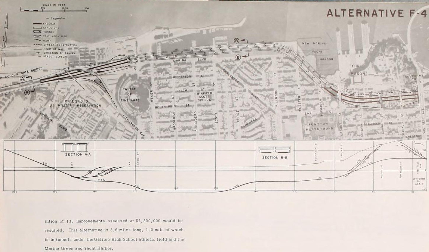
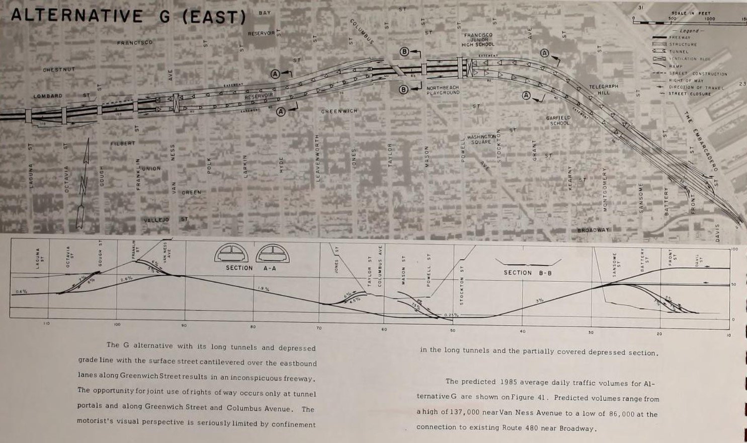
San Francisco Golden Gate Freeway Interstate 480" to the San Francisco Board of Supervisors. The technical report presented all the design alternatives for the Golden Gate Freeway between the end of the Embarcadero Freeway west to the previously adopted corridor in the Presidio of San Francisco. The Division of Highways seemingly favored the variations to Alternative F. The Alternative F designs generally favored trenched freeway designs and avoiding much of Russian Hill.
Below the corridor alternatives and design sketches for the Golden Gate Freeway can be seen.
The
May/June 1965 California Highways & Public Works updates the status of Interstate 480 on the Golden Gate Freeway. Public comments on the planned corridor of the Golden Gate Freeway were heard on April 9, 1965. The California Highway Commission met regarding selecting a routing of the Golden Gate Freeway on April 28, 1965 but deferred making a decision for 60 days due to studies being conducted by the San Francisco Board of Supervisors.
The California Highway Commission appears in a group photo seen in the
May/June 1965 California Highways & Public Works meeting regarding the corridor of the Golden Gate Freeway. Ultimately no corridor alternative for the Golden Gate Freeway between Broadway and the Presidio of San Francisco was selected. Interstate 480 was removed as a chargeable Interstate during August 1965. This measure freed up approximately five chargeable miles to be used elsewhere in California, two which were dedicated to rerouting Interstate 280 in San Francisco.
The
November/December 1965 California Highways & Public Works notes California State Route 82 and the Southern Embarcadero Extension Freeway between Newcomb Avenue-Army Street was close to completion. The new segment of the Southern Embarcadero Extension Freeway would connect to the existing viaduct to the US Route 101/James Lick Memorial Freeway Interchange.
The
November/December 1966 California Highways & Public Works notes the Southern Embarcadero Extension Freeway was under construction from Newcomb Avenue to 0.8 miles north of Army Street as part of Interstate 280. This volume of the California Highways & Public Works was the first to hint at the shifting corridor of Interstate 280 off of the planned 19th Avenue Freeway onto the Southern Embarcadero Extension Freeway.
The Southern Embarcadero Extension Freeway appears on the
1967 Division of Highways Map complete from US Route 101 northward beyond Army Street. Notably the Southern Embarcadero Extension Freeway is still shown to be part of California State Route 82 and California State Route 87 rather than Interstate 280.
The California Highways & Public Works publication ended with the January/February 1967 Volume and didn't provide closing resolution to the fate of the Golden Gate Freeway.
The corridor of the Golden Gate Freeway between Broadway and the Presidio of San Francisco was largely resolved via Legislative Chapter 282 which shuffled many of the freeway designations in San Francsico. Legislative Chapter 282 redefined Interstate 480 as being aligned from unbuilt Interstate 280 near Harrison Street in San Francisco to Route 1 and the approach to the Golden Gate Bridge in the Presidio of San Francisco. Interstate 280 via Legislative Chapter 282 was moved off the corridor of the planned 19th Avenue Freeway to what was California State Route 82 and California State Route 87 on the Southern Embarcadero Extension Freeway. The changes to California State Route 82, California State Route 87, Interstate 280 and Interstate 480 all appear on the
1969 Division of Highways Map.


During 1969 the City of San Francisco formally asked the Division of Highways to cease work on connecting Interstate 280 and Southern Embarcadero Extension Freeway to the Embarcadero Freeway. The Embarcadero Freeway would appear as California State Route 480 for the first time on the
1970 Division of Highways Map.
Interstate 280 and the Southern Embarcadero Extension Freeway would be completed to 3rd Street in San Francisco by 1973 which can be seen on the
1975 Caltrans Map.
Despite never having an adopted corridor the Golden Gate Freeway remained as part of the legislative definition of California State Route 480. Even the selected corridor of the Golden Gate Freeway in the Presidio of San Francisco would remain unconstructed in favor of existing US Route 101 on Doyle Drive. Doyle Drive had been constructed during 1933 as an elevated approach to the Golden Gate Bridge.
During the 1980s public opinion against the Embarcadero Freeway began to increase. On November 5, 1985, the San Francisco Board of Supervisors voted to tear down the Embarcadero Freeway. A proposal to remove the Embarcadero Freeway was put to voters during 1987 but was ultimately rejected largely over fears removal would negatively impact Chinatown. On October 17, 1989, the 6.9 magnitude Loma Prieta Earthquake struck the San Francisco Bay Area which damaged the Embarcadero Freeway. Initially Caltrans planned to retrofit he Embarcadero Freeway and reopen it. The Embarcadero Freeway and California State Route 480 appear for the final time on the
1990 Caltrans Map.


Ultimately the San Francisco Board of Supervisors would vote to demolish the Embarcadero Freeway. The entirety of California State Route 480 was deleted via 1991 Senate Bill 181, Chapter 498. The deletion of California State Route 480 reverted Lombard Street and Doyle Drive as part of the legislative definition of US Route 101. Demolition of the Embarcadero Freeway would begin on February 27, 1991. The Embarcadero Freeway can be seen in the process of demolition during May 1991 in front of the Ferry Terminal Building in the below
public domain photo. A small trace of the Embarcadero Freeway can still be found today in the form of Interstate 80 westbound Exit 2C towards Fremont Street and Folsom Street.

Ultimately a small element of the Golden Gate Freeway would live on as part of US Route 101 via the Presidio Parkway. Existing Doyle Drive was deemed vulnerable to earthquake damage and was recommended to be replaced by the San Francisco County Transportation Authority. The modern alignment of US Route 101 on Presidio Parkway from Lombard Street to the Golden Gate Bridge broke ground during December 2009 and would be fully opened to traffic during July 2012.
Part 2; a drive on the Southern Embarcadero Extension Freeway via Interstate 280
Interstate 280 northbound intersects US Route 101 at Exits 54A and 54B before transitioning onto what was once known as the Southern Embarcadero Extension Freeway. Interstate 280 from the San Mateo County Line north to 6th Street in San Francisco was named the "John F. Foran Freeway" by 1986 Concurrent Resolution 73, Chapter 49. John Foran was elected to State Assembly in 1962 and is mostly known for introducing legislation which led to the formation of Metropolitan Transportation Commission during 1970.
North of US Route 101 access to Oracle Park and a California Welcome Center is signed from Interstate 280 Exit 56 at Mariposa Street.
Interstate 280 north traffic to King Street and the Embarcadero is directed to use the two most left lanes approaching the freeway terminus.
As noted in Part 1, Interstate 280 was completed to 3rd Street in 1973. The freeway structure to 3rd Street was an elevated span which essentially was never used given the connection to the Embarcadero Freeway was not constructed. Traffic on Interstate 280 would subsequently empty onto Sixth Street and Brannan Street. After the Loma Prieta Earthquake and demolition of the Embarcadero Freeway the alignment Interstate 280 was reconfigured to empty onto King Street. The transition from the northern terminus of Interstate 280 onto King Street was completed by 1997.
Interstate 80 and US Route 101 bound traffic along King Street is directed to take 3rd Street in front of Oracle Park. King Street transitions to the Embarcadero east of Oracle Park.
Part 3; the remaining stub connection from Interstate 80 and the Embarcadero Freeway
As noted in Part 1 a trace of the Embarcadero Freeway can be found via westbound Interstate 80 Exit 2C towards Fremont Street and Folsom Street. Exit 2C contains elements which used to connect to the Embarcadero Freeway.
Part 4; a drive on the Embarcadero
Past Oracle Park the alignment of King Street leads directly onto the Embarcadero.
Approaching Pier 40 Embarcadero traffic is advised of how many garage spaces are open ahead on a Variable Message Sign.
Approaching Townsend Street, the San Francisco-Oakland Bay Bridge comes into view.
North of Townsend Street the Embarcadero is adorned with
49 Mile Scenic Drive shields approaching the Bay Bridge. 49 Mile Scenic Drive is an auto-tour route of San Francisco which was created in 1938. 49 Mile Scenic Drive was created by the San Francisco Downtown Association to showcase the most scenic parts of the city during the Golden Gate International Exposition. Various realignments over the years have reduced the route to 46.3 miles.
The Embarcadero passes under the San Francisco-Oakland Bay Bridge between Bryant Street and Harrison Street.
Rincon Park is located at Embarcadero and Folsom Street.
Approaching Howard Street, the Ferry Terminal Building can be seen looking north on the Embarcadero. Howard Street is where the double decker Embarcadero Freeway would have once appeared overhead.
Yerba Buena Island and the San Francisco-Oakland Bay Bridge can be seen from Embarcadero and Howard Street.
At Mission Street the Ferry Terminal Building comes into full view looking north on the Embarcadero.
Approaching Market Street, the clock tower of the Ferry Terminal Building is easy to observe.
The Embarcadero Freeway as completed would have terminated north of the Ferry Terminal Building at Broadway.
At Pier 27 the Embarcadero intersects Battery Street and Lombard Street.
Traffic to the Golden Gate Bridge is directed to exit Embarcadero onto Bay Street. Many of the Alternative F corridors presented by the Division of Highways would have largely followed Bay Street.
At Pier 39 the Embarcadero enters the Fisherman's Wharf District. Pier 39 is located at the corner of Embarcadero and Jefferson Street. Traffic headed to Jefferson Street is directed to stay on the Embarcadero.
At Powell Street the Embarcadero takes a somewhat obtuse right hand turn towards it's terminus at Pier 45. From North Point Alcatraz Island can be seen in the waters of San Francisco Bay.
Part 5; a drive on US Route 101 via Park Presidio Parkway
As noted in Part 1 modern US Route 101 from Lombard Street to the Golden Gate Bridge footing contains an element of the planned Golden Gate Freeway in the form of modern Presidio Parkway. Presidio Parkway was completed in 2012 and is fully limited access. Presidio Parkway passes through two tunnel structures and intersects California State Route 1/Veterans Boulevard approaching the Golden Gate Bridge.


Comments