
The current route of Interstate 580 is 76 miles long and is one of the most important freeways in California. Interstate 580 westbound stretches from Interstate 5 in San Joaquin County west over Altamont Pass of Alameda County to Interstate 80 in Oakland. From Oakland the route of Interstate 580 continues westward over San Francisco Bay to US Route 101 in San Rafael of Marin County via the Richmond-San Rafael Bridge. The route of Interstate 580 occupies a historic corridor that carried highways such as; El Camino Viejo, the Lincoln Highway, US Route 48, California State Route 17 and US Route 50. Interstate 580 even was intended to be one of the primary components to what would have been Interstate 5 West.

Part 1; the history of transportation over Altamont Pass and lead up to Interstate 580
The first major highway over the present general corridor of Interstate 580 ("I-580") was El Camino Viejo. The El Camino Viejo was an inland alternate route to the Spanish Missions between Los Angeles and San Francisco Bay that was in common usage by the 1780s. The route of the El Camino Viejo from Los Angeles traveled north through San Francisquito Canyon, Antelope Valley, Cuddy Canyon and San Emigdio to reach San Joaquin Valley. El Camino Viejo in San Joaquin Valley followed the west shores of Tulare Lake and the San Joaquin River close to modern day Tracy where it picked up what is the general vicinity of the I-580 corridor. Rather than using Altamont Pass the route of the El Camino Viejo traveled west from modern day Tracy via Corral Hollow Pass to what is now Livermore. The route of Corral Hollow Pass has been since incorporated into County Sign Route J2.
The first real automotive highway on the corridor of I-580 was Legislative Route Number 5 ("LRN 5"). LRN 5 occupied the current I-580 corridor from Tracy westward to downtown Oakland. What became LRN 5 was part of the 1909 First State Highway Bond Act routes which were approved by California voters in 1910.
CAhighways.org; Highway Chronology Chapter 1
The first signed highway on the I-580 corridor from Tracy west to Oakland was the Lincoln Highway which had been established by 1913. The Lincoln Highway essentially was located on LRN 5 which ascended over the Diablo Range via Altamont Pass on Altamont Pass Road. The Lincoln Highway was present on the route over Altamont Pass until 1928 when it was shifted to a new alignment over the original Carquinez Bridge. The 1920 California/Nevada Clauson Highway Map shows the Lincoln Highway when it was routed over the I-580 corridor from Tracy to Oakland.
1920 California/Nevada Highway Map

Much of the early history of the Lincoln Highway over Altamont Pass can be found on this Gribblenation article below:
Hunting the early Lincoln Highway and US Route 48 from French Camp west over Altamont Pass
By late 1926 the US Route system was created and the corridor of I-580 from Tracy west to Hayward became part of US Route 48 ("US 48"). Originally US 48 traveled south from Hayward to San Jose which left only the Lincoln Highway to depart northwest on LRN 5 to Oakland. In 1929 US 101 was split into East/West branches around San Francisco Bay and US 101E was assigned to LRN 5 from Oakland to Hayward on the corridor of I-580. Like the Lincoln Highway the route of US 48 utilized Altamont Pass Road to cross the Diablo Range. US 101E and US 48 can be seen on the current I-580 corridor between Tracy and Oakland on the 1930 Division of Highways Map.
1930 Division of Highways Map
The 8th Biennial Report of the Division of Highways from November 1932 identified US 50 being extended from Sacramento all the way west to Oakland where it terminated at US 40 along what is now MacArthur Boulevard and San Pablo Avenue.

The western extension of US 50 occupied the corridor of I-580 from Tracy west to Oakland which can be seen on the 1936 Division of Highways Map.
1936 Division of Highways Map

On August 4th, 1938 the path of US 50 over Altamont Pass via New Altamont Pass Road was opened to the public. The opening event and new alignment of US 50 is covered extensively in the September 1938 California Highways and Public Works. Today the route of the New Altamont Pass Road carries the eastbound lanes of I-580.


The Western Pacific Rail Overpass mentioned above in the September 1938 California Highways & Public Works appears much as it did in 1938 from present I-580 eastbound.


Up close "Western Pacific" can still be seen on a stencil from I-580 eastbound.

The current route of I-580 from I-5 west to I-80 in Oakland was originally slated to become Interstate 5 West ("I-5W"). Specifically the corridor of US 50 was selected to become I-5W in the 1947 version of the Interstate Highway System (which ultimately never was built). The present Interstate Highway System traces it's origins to the Federal Highway Aid Act of 1956. In the 1956 version of the Interstate System the route of I-5 was to run through Central California with the I-5E spur following the corridor of US 99 north of Modesto and I-5W following the corridor below:
- Modern CA 132 west to I-580.
- Modern I-580 west to I-80.
- Modern I-80 east to I-505.
- Modern I-505 to I-5.
The present route of I-580 from CA 132 west to I-205 was added to the State Highway system in 1957 as an extension of LRN 110 by the State Legislature according to CAhighways.org.
CAhighways.org on LRN 110
Since CA 132 west of US 99 was meant to become part of I-5W the route of LRN 110 was extended west and met US 50/LRN 5 in Tracy. This can be seen on the 1958 State Division of Highways Map.
1958 Division of Highways Map

By 1959 the State Legislature approved widening LRN 110 into a bypass of Tracy which is when the final planned route of I-580 from I-5 to I-205 took form. This can be seen on the 1960 Division of Highways Map.
1960 Division of Highways Map

What ultimately prevented I-580 from current I-5 west to I-80 becoming I-5W was likely the 1964 State Highway renumbering which discontinued the use of suffixed routes. The present number of I-580 appears as a Legislative Route Number alongside US 50 between Tracy and Oakland on the 1964 Division of Highways Map.
1964 State Highway Map

I-5W was field signed along the current corridor I-580 between Tracy and Oakland as evidenced by this photo from the July/August 1962 California Division of Highways Guide. The photo below shows I-5W on the current MacArthur/I-580 freeway near Broadway in Oakland.


Part 1; the history of transportation over Altamont Pass and lead up to Interstate 580
The first major highway over the present general corridor of Interstate 580 ("I-580") was El Camino Viejo. The El Camino Viejo was an inland alternate route to the Spanish Missions between Los Angeles and San Francisco Bay that was in common usage by the 1780s. The route of the El Camino Viejo from Los Angeles traveled north through San Francisquito Canyon, Antelope Valley, Cuddy Canyon and San Emigdio to reach San Joaquin Valley. El Camino Viejo in San Joaquin Valley followed the west shores of Tulare Lake and the San Joaquin River close to modern day Tracy where it picked up what is the general vicinity of the I-580 corridor. Rather than using Altamont Pass the route of the El Camino Viejo traveled west from modern day Tracy via Corral Hollow Pass to what is now Livermore. The route of Corral Hollow Pass has been since incorporated into County Sign Route J2.
The first real automotive highway on the corridor of I-580 was Legislative Route Number 5 ("LRN 5"). LRN 5 occupied the current I-580 corridor from Tracy westward to downtown Oakland. What became LRN 5 was part of the 1909 First State Highway Bond Act routes which were approved by California voters in 1910.
CAhighways.org; Highway Chronology Chapter 1
The first signed highway on the I-580 corridor from Tracy west to Oakland was the Lincoln Highway which had been established by 1913. The Lincoln Highway essentially was located on LRN 5 which ascended over the Diablo Range via Altamont Pass on Altamont Pass Road. The Lincoln Highway was present on the route over Altamont Pass until 1928 when it was shifted to a new alignment over the original Carquinez Bridge. The 1920 California/Nevada Clauson Highway Map shows the Lincoln Highway when it was routed over the I-580 corridor from Tracy to Oakland.
1920 California/Nevada Highway Map

Much of the early history of the Lincoln Highway over Altamont Pass can be found on this Gribblenation article below:
Hunting the early Lincoln Highway and US Route 48 from French Camp west over Altamont Pass
By late 1926 the US Route system was created and the corridor of I-580 from Tracy west to Hayward became part of US Route 48 ("US 48"). Originally US 48 traveled south from Hayward to San Jose which left only the Lincoln Highway to depart northwest on LRN 5 to Oakland. In 1929 US 101 was split into East/West branches around San Francisco Bay and US 101E was assigned to LRN 5 from Oakland to Hayward on the corridor of I-580. Like the Lincoln Highway the route of US 48 utilized Altamont Pass Road to cross the Diablo Range. US 101E and US 48 can be seen on the current I-580 corridor between Tracy and Oakland on the 1930 Division of Highways Map.
1930 Division of Highways Map

The 8th Biennial Report of the Division of Highways from November 1932 identified US 50 being extended from Sacramento all the way west to Oakland where it terminated at US 40 along what is now MacArthur Boulevard and San Pablo Avenue.

The western extension of US 50 occupied the corridor of I-580 from Tracy west to Oakland which can be seen on the 1936 Division of Highways Map.
1936 Division of Highways Map

On August 4th, 1938 the path of US 50 over Altamont Pass via New Altamont Pass Road was opened to the public. The opening event and new alignment of US 50 is covered extensively in the September 1938 California Highways and Public Works. Today the route of the New Altamont Pass Road carries the eastbound lanes of I-580.


The Western Pacific Rail Overpass mentioned above in the September 1938 California Highways & Public Works appears much as it did in 1938 from present I-580 eastbound.


The current route of I-580 from I-5 west to I-80 in Oakland was originally slated to become Interstate 5 West ("I-5W"). Specifically the corridor of US 50 was selected to become I-5W in the 1947 version of the Interstate Highway System (which ultimately never was built). The present Interstate Highway System traces it's origins to the Federal Highway Aid Act of 1956. In the 1956 version of the Interstate System the route of I-5 was to run through Central California with the I-5E spur following the corridor of US 99 north of Modesto and I-5W following the corridor below:
- Modern CA 132 west to I-580.
- Modern I-580 west to I-80.
- Modern I-80 east to I-505.
- Modern I-505 to I-5.
The present route of I-580 from CA 132 west to I-205 was added to the State Highway system in 1957 as an extension of LRN 110 by the State Legislature according to CAhighways.org.
CAhighways.org on LRN 110
Since CA 132 west of US 99 was meant to become part of I-5W the route of LRN 110 was extended west and met US 50/LRN 5 in Tracy. This can be seen on the 1958 State Division of Highways Map.
1958 Division of Highways Map

By 1959 the State Legislature approved widening LRN 110 into a bypass of Tracy which is when the final planned route of I-580 from I-5 to I-205 took form. This can be seen on the 1960 Division of Highways Map.
1960 Division of Highways Map

What ultimately prevented I-580 from current I-5 west to I-80 becoming I-5W was likely the 1964 State Highway renumbering which discontinued the use of suffixed routes. The present number of I-580 appears as a Legislative Route Number alongside US 50 between Tracy and Oakland on the 1964 Division of Highways Map.
1964 State Highway Map

I-5W was field signed along the current corridor I-580 between Tracy and Oakland as evidenced by this photo from the July/August 1962 California Division of Highways Guide. The photo below shows I-5W on the current MacArthur/I-580 freeway near Broadway in Oakland.

The July/August 1962 California Highways & Public Works also has an extensive article about the MacArthur Freeway opening. A ribbon cutting ceremony was held on May 15th, 1962 to celebrate the completion of a 2.6 mile section of I-5W/US 50 opening in Oakland between what is now I-80 and Grand Avenue.


On April 13th, 1963 the California Division of Highways petitioned the AASHO to truncate US 50 from San Francisco to Sacramento due to it being carried by numerous other highways. It is unclear when the AASHO Executive Committee approved the truncation of US 50 as it was field signed on the corridor of I-580 for several more years.


On April 13th, 1963 the California Division of Highways petitioned the AASHO to truncate US 50 from San Francisco to Sacramento due to it being carried by numerous other highways. It is unclear when the AASHO Executive Committee approved the truncation of US 50 as it was field signed on the corridor of I-580 for several more years.


Prior to 1964 I-5 is shown splitting into I-5W/I-5E near Tracy on some commercial maps. This map below is dated from 1963 and shows I-5W/US 50 multiplexed over Altamont Pass towards CA 21.

I-580 is shown partially complete between what would become I-5 and I-205 on the 1966 Division of Highways Map.
1966 Division of Highways Map

I-580 appears signed in segments between I-5 and Oakland on the 1967 Division of Highways Map.
1967 Division of Highways Map

I-580 is shown complete between I-5 and I-205 on the 1969 Division of Highways Map.
1969 Division of Highways Map

The completed route of I-580 from I-5 west to I-80 appears between the 1970 Division of Highways Map and 1975 Caltrans Maps. Note; the I-5 south overpass of I-580 shows a build date of 1971.
1970 Division of Highways Map

1975 Caltrans Highway Map

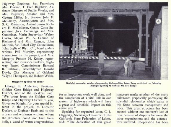
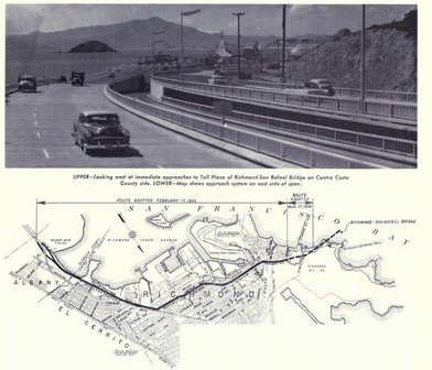
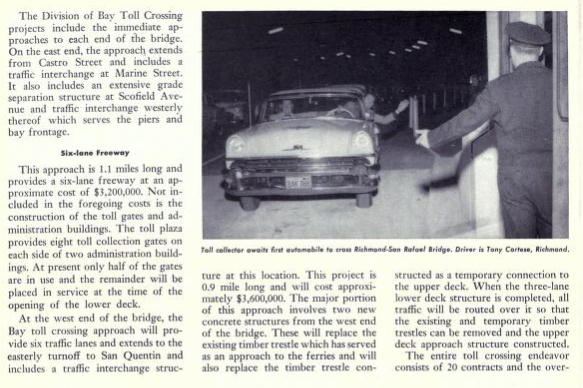
By 1984 the route of I-580 was extended via Legislative Chapter 409 over the Richmond-San Rafael Bridge which was former CA 17 to US 101. The history of the Richmond-San Rafael Bridge is as follows:
On September 1, 1956 The Richmond-San Rafael Bridge was opened to traffic which replaced the ferry route between Point San Quentin and Castro Point. On the 1957 Division of Highways State Map LRN 69 is shown to be extended to the Richmond-San Rafael Bridge. By 1960 state maintenance of the Richmond-San Rafael Bridge is shown along with CA 17 extended to US 101 in San Rafael. CA 17 initially utilized a surface routing through Richmond via Hoffman Boulevard and Cutting Boulevard to reach the Richmond-San Rafael Bridge.
1957 Division of Highways Map

1960 Division of Highways Map

The opening the Richmond-San Rafael Bridge is discussed in the September/October 1956 California Highways and Public Works.


The route of CA 17 is stated to be extended over the Richmond-San Rafael Bridge to US 101 by 1957 according to the March/April 1957 California Highways and Public Works. Funding to build CA 17 from the western approach of the Richmond-San Rafael Bridge as a freeway to US 101 is cited as being ear marked for the 1958-59 fiscal years.


Part 2; a drive on Interstate 580
From I-5 northbound I-580 westbound begins from a left hand split interchange.


I-580 west of I-5 is signed as the W.E. "Brownie" Brown Freeway. The W.E. "Brownie" Brown Freeway designation is carried all the way to I-205.

I-580 westbound Exit 76 is signed access to CA 132 via Chrisman Road.


I-580 west passes under CA 132, traffic is advised San Francisco is 67 miles away.


At Exit 72 I-580 westbound accesses County Sign Route J2 via Corral Hollow Road.


Patterson Pass Road is accessible from I-580 westbound Exit 67.


I-580 westbound doesn't access I-205 eastbound directly. I-580 westbound traffic is advised to utilize the truck bypass lanes at Exit 63 to reach Grant Line Road. I-580 westbound ascends over the travel lanes of I-205 and converges into the flow of traffic of I-205 westbound out of Tracy.


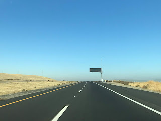
I-580 west of I-205 enters Alameda County and begins to climb to the Diablo Range to Altamont Pass. These photos of I-580 westbound were taken during the winter of 2019 which is why the terrain is far greener.


I-580 west of I-205 is signed as 11 miles from Livermore and 43 miles from Oakland.


I-580 ascends a massive grade west of I-205 to the 1,009 foot Altamont Pass. Altamont Pass has a massive wind farm which usually is quite active despite the low elevation in the Diablo Range. Access to Flynn Road can be found at I-580 westbound Exit 59 at Altamont Pass.


The Lincoln Highway, US 48 and US 50 used a lower route to the north on Altamont Pass Road. Altamont Pass Road has a peak elevation of 741 feet which is considerably mild by California Standards. The original alignment of the Lincoln Highway, US 48 and US 50 over Altamont Pass can be seen on the 1935 California Division Highways Maps of San Joaquin County and Alameda County.
1935 Division of Highways Map of San Joaquin County

1935 Division of Highways Map of Alameda County

I-580 west of Altamont Pass is signed as the "CHP Officer John P. Miller Memorial Freeway." The CHP Officer John P. Miller Memorial Freeway designation carries on I-580 westbound to Airway Boulevard.

I-580 west descends Altamont Pass into Livermore. I-580 west Exit 57 in Livermore accesses Altamont Pass Road.


I-580 west has express toll lanes starting in Livermore. I-580 westbound Exit 55 in Livermore accesses Vasco Road which was part of the planned corridor of CA 84.

I-580 west has plenty of button-copy signage in Livermore. This sign features a green cover plate on the Exit 54/1st Street sign. The cover plate was placed over a CA 84 shield as First Street given it is an older alignment of the highway.

I-580 westbound accesses County Sign Route J2 at Exit 52/Livermore Avenue. I-580 westbound accesses CA 84 in Livermore at Exit 51/Isabel Avenue.


I-580 westbound enters Dublin approaching I-680 where it is known as the Arthur H. Breed Jr. Freeway west to Castro Valley. I-580 westbound in Dublin contains numerous Exits; Exit 48/Fallon Road, Tassajara Road/Exit 47, Hacienda Drive/Exit 46 and Dougherty Road/Hopyard Road/Exit 45.

I-580 westbound accesses I-680 via Exit 44B.


I-580 westbound as signed 7.5 miles away from Castro Valley at the I-680 junction.

I-580 westbound begins to ascend Hayward Pass alongside a Bay Area Rapid Transit line in the freeway median. Oakland is signed as being 23 miles to the west, access to San Ramon Road can be found at Exit 44A.


As I-580 westbound descends from Hayward Pass it intersects Eden Canyon Road at Exit 39.


I-580 westbound enters Castro Valley and meets Castro Valley Boulevard at Exit 37. Castro Valley Boulevard is the former surface alignment of the Lincoln Highway, US 48 and US 50. I-580 westbound from Castro Valley Boulevard to Strobridge Avenue is signed as the Sergeant Daniel Sakai Oakland Police Officer Memorial Freeway.


I-580 westbound Exit 36 accesses Redwood Road whereas Exit 35 accesses Strobridge Avenue. I-580 westbound truck traffic is advised to take I-238 west to I-880 to reach Oakland. I-580 westbound junctions I-238 at Exit 34.


I-580 westbound from I-238 to I-80 in Oakland is signed as the MacArthur Freeway. I-580 westbound in Castro Valley accesses Foothill Boulevard at Exits 33 and 32B before entering San Leandro. I-580 westbound in San Leandro has Exits at; Benedict Drive/Exit 32A, Grand Avenue/Exit 31 and MacArthur Boulevard/Exit 30. I-580 westbound enters the City of Oakland and accesses 98th Street via Exit 29. I-580 westbound Exit 29 is signed as access to the Oakland Coliseum and Oakland International Airport.


I-580 westbound Exit 27 accesses Keller Avenue. I-580 westbound Exit 26B accesses Seminar Avenue whereas Exit 26A accesses CA 13/Warren Freeway.


I-580 westbound Exit 25 accesses MacArthur Boulevard whereas access to Coolidge Avenue can be found at Exit 24. Coolidge Avenue is signed as access to Peralta Hacienda Historical Park.


There are several important junctions along I-580 westbound in downtown Oakland. I-580 westbound accesses 14th Avenue/Park Boulevard at Exit 22B and Lakeshore Avenue at Exit 22A. Access to MacArthur Boulevard can be found at At Exit 21A whereas access to Grand Avenue can be found at Exit 21B. I-580 westbound Exit 19C accesses CA 24 eastbound and at Exit 19D accesses I-980 westbound. I-580 westbound Exit 19B accesses former US 40 on San Pablo Avenue.


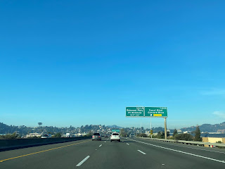
Exit 19A accesses I-80 westbound towards the Oakland-San Francisco Bay Bridge towards San Francisco. I-580 westbound enters a wrong-way concurrency with I-80 eastbound.


I-580 westbound/I-80 eastbound enters Emeryville and accesses Powell Street at Exit 9 (the Exit numbers are taken from I-80 on the I-580/I-80 multiplex).

There is a fairly unique VMS showing times to major highways on I-580 westbound/I-80 eastbound in Emeryville.

At Exit 10 I-580 westbound/I-80 eastbound Exit 10 accesses CA 13/Ashby Avenue.

1957 Division of Highways Map

1960 Division of Highways Map

The opening the Richmond-San Rafael Bridge is discussed in the September/October 1956 California Highways and Public Works.


The route of CA 17 is stated to be extended over the Richmond-San Rafael Bridge to US 101 by 1957 according to the March/April 1957 California Highways and Public Works. Funding to build CA 17 from the western approach of the Richmond-San Rafael Bridge as a freeway to US 101 is cited as being ear marked for the 1958-59 fiscal years.

Part 2; a drive on Interstate 580
From I-5 northbound I-580 westbound begins from a left hand split interchange.


I-580 west of I-5 is signed as the W.E. "Brownie" Brown Freeway. The W.E. "Brownie" Brown Freeway designation is carried all the way to I-205.

I-580 westbound Exit 76 is signed access to CA 132 via Chrisman Road.


I-580 west passes under CA 132, traffic is advised San Francisco is 67 miles away.


At Exit 72 I-580 westbound accesses County Sign Route J2 via Corral Hollow Road.


Patterson Pass Road is accessible from I-580 westbound Exit 67.


I-580 westbound doesn't access I-205 eastbound directly. I-580 westbound traffic is advised to utilize the truck bypass lanes at Exit 63 to reach Grant Line Road. I-580 westbound ascends over the travel lanes of I-205 and converges into the flow of traffic of I-205 westbound out of Tracy.


I-580 west of I-205 enters Alameda County and begins to climb to the Diablo Range to Altamont Pass. These photos of I-580 westbound were taken during the winter of 2019 which is why the terrain is far greener.


I-580 west of I-205 is signed as 11 miles from Livermore and 43 miles from Oakland.


I-580 ascends a massive grade west of I-205 to the 1,009 foot Altamont Pass. Altamont Pass has a massive wind farm which usually is quite active despite the low elevation in the Diablo Range. Access to Flynn Road can be found at I-580 westbound Exit 59 at Altamont Pass.


The Lincoln Highway, US 48 and US 50 used a lower route to the north on Altamont Pass Road. Altamont Pass Road has a peak elevation of 741 feet which is considerably mild by California Standards. The original alignment of the Lincoln Highway, US 48 and US 50 over Altamont Pass can be seen on the 1935 California Division Highways Maps of San Joaquin County and Alameda County.
1935 Division of Highways Map of San Joaquin County

1935 Division of Highways Map of Alameda County

I-580 west of Altamont Pass is signed as the "CHP Officer John P. Miller Memorial Freeway." The CHP Officer John P. Miller Memorial Freeway designation carries on I-580 westbound to Airway Boulevard.

I-580 west descends Altamont Pass into Livermore. I-580 west Exit 57 in Livermore accesses Altamont Pass Road.


I-580 west has express toll lanes starting in Livermore. I-580 westbound Exit 55 in Livermore accesses Vasco Road which was part of the planned corridor of CA 84.

I-580 west has plenty of button-copy signage in Livermore. This sign features a green cover plate on the Exit 54/1st Street sign. The cover plate was placed over a CA 84 shield as First Street given it is an older alignment of the highway.

I-580 westbound accesses County Sign Route J2 at Exit 52/Livermore Avenue. I-580 westbound accesses CA 84 in Livermore at Exit 51/Isabel Avenue.


I-580 westbound enters Dublin approaching I-680 where it is known as the Arthur H. Breed Jr. Freeway west to Castro Valley. I-580 westbound in Dublin contains numerous Exits; Exit 48/Fallon Road, Tassajara Road/Exit 47, Hacienda Drive/Exit 46 and Dougherty Road/Hopyard Road/Exit 45.

I-580 westbound accesses I-680 via Exit 44B.


I-580 westbound as signed 7.5 miles away from Castro Valley at the I-680 junction.

I-580 westbound begins to ascend Hayward Pass alongside a Bay Area Rapid Transit line in the freeway median. Oakland is signed as being 23 miles to the west, access to San Ramon Road can be found at Exit 44A.


As I-580 westbound descends from Hayward Pass it intersects Eden Canyon Road at Exit 39.


I-580 westbound enters Castro Valley and meets Castro Valley Boulevard at Exit 37. Castro Valley Boulevard is the former surface alignment of the Lincoln Highway, US 48 and US 50. I-580 westbound from Castro Valley Boulevard to Strobridge Avenue is signed as the Sergeant Daniel Sakai Oakland Police Officer Memorial Freeway.


I-580 westbound Exit 36 accesses Redwood Road whereas Exit 35 accesses Strobridge Avenue. I-580 westbound truck traffic is advised to take I-238 west to I-880 to reach Oakland. I-580 westbound junctions I-238 at Exit 34.


I-580 westbound from I-238 to I-80 in Oakland is signed as the MacArthur Freeway. I-580 westbound in Castro Valley accesses Foothill Boulevard at Exits 33 and 32B before entering San Leandro. I-580 westbound in San Leandro has Exits at; Benedict Drive/Exit 32A, Grand Avenue/Exit 31 and MacArthur Boulevard/Exit 30. I-580 westbound enters the City of Oakland and accesses 98th Street via Exit 29. I-580 westbound Exit 29 is signed as access to the Oakland Coliseum and Oakland International Airport.


I-580 westbound Exit 27 accesses Keller Avenue. I-580 westbound Exit 26B accesses Seminar Avenue whereas Exit 26A accesses CA 13/Warren Freeway.


I-580 westbound Exit 25 accesses MacArthur Boulevard whereas access to Coolidge Avenue can be found at Exit 24. Coolidge Avenue is signed as access to Peralta Hacienda Historical Park.


There are several important junctions along I-580 westbound in downtown Oakland. I-580 westbound accesses 14th Avenue/Park Boulevard at Exit 22B and Lakeshore Avenue at Exit 22A. Access to MacArthur Boulevard can be found at At Exit 21A whereas access to Grand Avenue can be found at Exit 21B. I-580 westbound Exit 19C accesses CA 24 eastbound and at Exit 19D accesses I-980 westbound. I-580 westbound Exit 19B accesses former US 40 on San Pablo Avenue.


Exit 19A accesses I-80 westbound towards the Oakland-San Francisco Bay Bridge towards San Francisco. I-580 westbound enters a wrong-way concurrency with I-80 eastbound.


I-580 westbound/I-80 eastbound enters Emeryville and accesses Powell Street at Exit 9 (the Exit numbers are taken from I-80 on the I-580/I-80 multiplex).

There is a fairly unique VMS showing times to major highways on I-580 westbound/I-80 eastbound in Emeryville.

At Exit 10 I-580 westbound/I-80 eastbound Exit 10 accesses CA 13/Ashby Avenue.

I-580 westbound/I-80 eastbound enters Berkeley where Exit 11 accesses University Avenue.


I-580 westbound/I-80 eastbound Exit 12 accesses Gilman Avenue.


I-580 westbound/I-80 eastbound enter Albany and access Buchanan Street at Exit 13A. I-580 westbound departs I-80 eastbound via Exit 13A.


I-580 westbound enters Richmond and Contra Costa County. I-580 westbound accesses Central Avenue at Exit 12.


I-580 westbound Exit 10B accesses Regatta Avenue.


I-580 westbound Exit 10A accesses Marina Bay Parkway and South 23rd Street.


I-580 westbound Exit 9A/9B access Harbour Way.


I-580 westbound begins to approach the Richmond-San Rafael Bridge. At Exit 7A I-580 westbound accesses Stenmark Drive. Stenmark Drive is the last Exit on I-580 westbound before the Richmond-San Rafael Bridge tollbooths.


I-580 westbound Exit 8 accesses Canal Boulevard and Garrard Boulevard.


I-580 westbound Exit 7B accesses Richmond Parkway. Richmond Parkway is part of Contra Costa County Route 93 and was the planned corridor of CA 93.


I-580 westbound passes through the tollbooths approaching the Richmond-San Rafael Bridge.


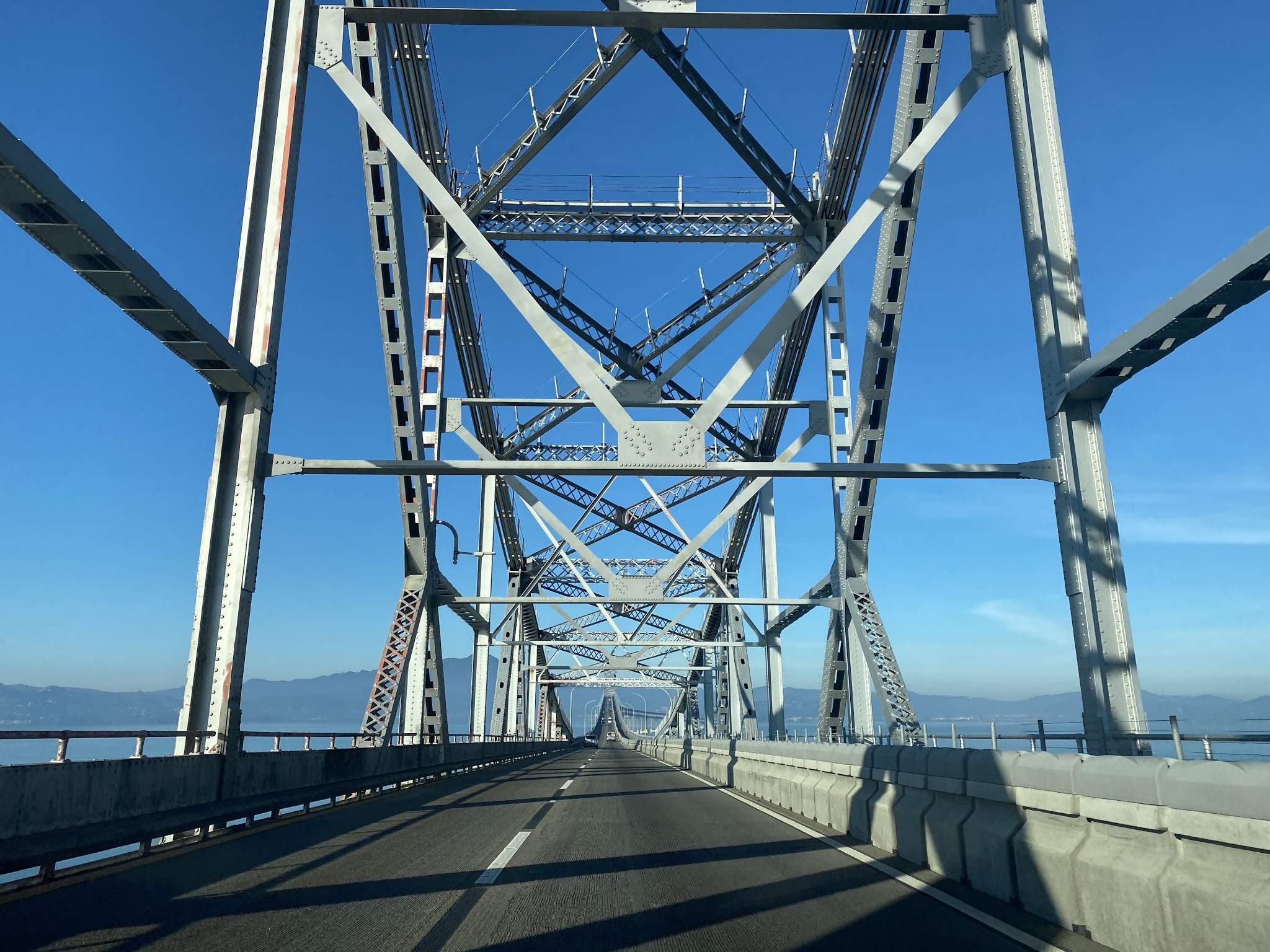
I-580 westbound crosses San Francisco Bay on the top deck of the Richmond-San Rafael Bridge into Marin County. The Richmond-San Rafael Bridge is 5.5 miles in length and features a truss design. The bike lane on the Richmond-San Rafael Bridge was intended to a be a third travel but was converted to pedestrian use which was completed by November 2019.


I-580 westbound descends from the Richmond-San Rafael Bridge to Point San Quentin. A vista can be found at I-580 westbound Exit 2B in San Quentin.


The view of the Richmond-San Rafael Bridge from Point San Quentin.

I-580 westbound Exit 2A accesses Sir Francis Drake Boulevard. US 101 southbound traffic is directed to take Sir Francis Drake Boulevard from I-580 westbound. Sir Francis Drake Boulevard between I-580 and US 101 is part of the never built corridor of CA 251.


Comments