
Bridge Monday; the Roosevelt Lake Bridge and Roosevelt Dam

Back in the early 2010s I frequently visited Gila County Arizona.  Often my travel took me up Arizona State Route 88 (usually for fun) and Arizona State Route 188.  The junction of AZ 88 and AZ 188 holds what was two significant bridging structures of Roosevelt Lake; the Roosevelt Dam and Roosevelt Lake Arch Bridge.


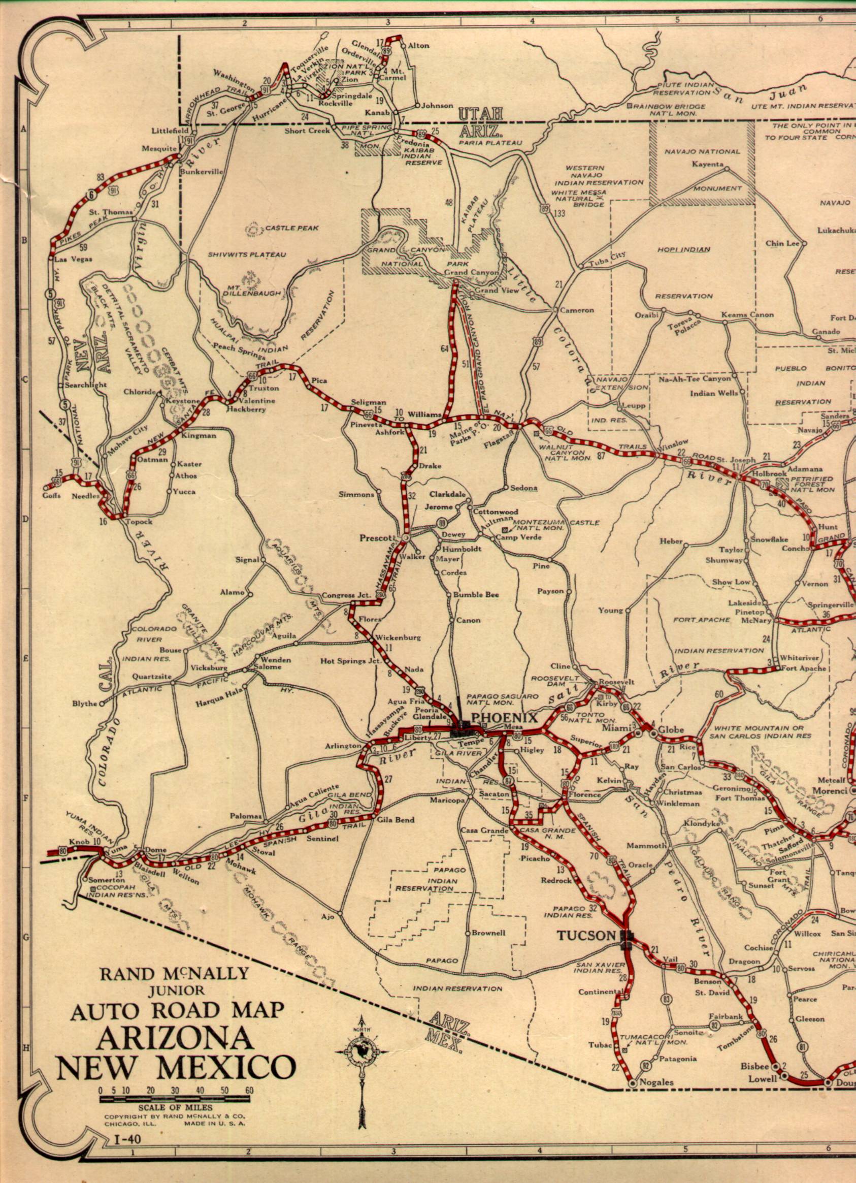
AZ 88 is one of the oldest State Highways in Arizona dating back to 1927.  While the highway was originally intended to be signed as AZ 66 the designation of AZ 88 was ultimately chosen due to US 66 being assigned over what was intended to be US 60 in Arizona.  As originally signed AZ 88 stretched from US Route 80 in Apache Junction east to the first US 180 in Globe.  By 1927 Roosevelt Dam was long completed since 1911 as it was the signature structure of the Salt River Project.  Roosevelt Dam was used as a bridging structure from AZ 88 north to the road to Payson.  This 1927 highway map of Arizona shows the location of Roosevelt Dam on the initial alignment of AZ 88.


Construction of Roosevelt Dam began along the Salt River in Gila County by 1903, as stated above the structure was completed by 1911.  Roosevelt Dam and the Salt River Project were part of the 1902 Reclamation Act which paved the way for later more well known public works projects such as the Hoover Dam.  Roosevelt Dam as originally completed was a completely masonry dam and was the largest of it's type at the time.  


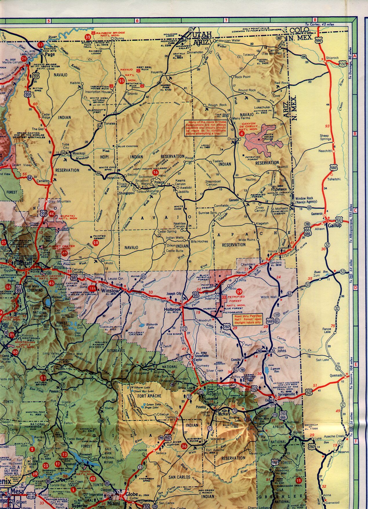
According to Arizonaroads.com the route of AZ 188 from AZ 88 at Roosevelt Dam north to Payson was designated in 1958.  At the time the junction of AZ 88 and AZ 188 was at Roosevelt Dam.   AZ 188 can be viewed in it's originally configuration crossing Roosevelt Dam on the 1961 State Highway Map.


In 1989 an expansion project to raise Roosevelt Dam from 280 feet to 357 began.  Said project was to expand Roosevelt Dam via use of a new masonry cover over the original dam structure.  The Roosevelt Dam expansion project required AZ 188 be shifted onto a new bridge over Roosevelt Lake.  The new Roosevelt Lake Arch bridge was completed by 1992 and remains one of the more scenic bridges in Arizona. 


According to Arizonaroads.com AZ 188 was shifted over what was AZ 88 east of Roosevelt Dam to Globe by 2000.  The change was apparently instigated due to a new ADOT policy about having a highway have both terminus points at the same route.  


Comments

Popular posts from this blog

What's In a Name?: When the Roads Really Do Tell a Story

  Our tagline on the Gribblenation blog is "because every road tells a story". Some roads tell different stories than others. Along our travels, we may see historic markers that tell us a little story about the roads we travel or the places we pass by. Some historic markers are more general, as to telling us who lived where or what old trail traversed between two towns. During my travels across New York State and other states or provinces, I pass by many historic markers, some with interesting or amusing references to roads. I wanted to highlight a few of the markers I've seen along my travels around the Empire State and help tell their stories. Those stories may be as specific as explaining the tales of a tree that was used to help measure a distance of eight miles from Bath to Avoca in Steuben County, as referenced on the Eight Mile Tree historical marker above. They may also help point the way along historical roads first used centuries ago, or may help tell a local l...

2018 Mojave Road Trip Part 2; The deadly desert highway (California State Route 127 and Nevada State Route 373)

After leaving Barstow via Old Highway 58 my next destination was in Death Valley.  To access Death Valley from rural San Bernardino County required a trek on north on Interstate 15 to California State Route 127 which becomes Nevada State Route 373 at the state line. Along I-15 I encountered the road sign oddity that is Zzyzx Road about eight miles south of Baker.   Zzyzx Road is a four mile road that used to go to the Zzyzx Mineral Springs and Health Spa.   The spa was founded in the 1940s and the owner made up the name "Zzyzx" to claim it was the last word in the English Language.  The spa has been shut down since the 1970s and is now part of a Desert Studies Center for California State University. The southern terminus of CA 127 in Baker is located at I-15 exit 246.  CA 127 is a 91 mile north/south highway which runs to the Nevada State Line in Inyo County.  CA 127 is called Death Valley Road from I-15 northward.  South of CA 127 ...

May 2023 Ontario Trip (Part 3 of 3)

  Over the years, I have made plenty of trips to Ontario, crisscrossing the southern, central and eastern parts of the province. Living in Upstate New York, it's pretty easy to visit our neighbor to the north, or is that our neighbor to the west? Ottawa is one of my favorite cities to visit anywhere in the world, plus I've discovered the charm of Kingston, the waterfalls of Hamilton (which is on the same Niagara Escarpment that brings us Niagara Falls), the sheer beauty of the Bruce Peninsula, and more. But I hadn't explored much of Cottage Country. So I decided to change that, and what better time to go than over Memorial Day weekend, when the daylight is long and I have an extra day to explore. On the third and final day of my trip, I started in Huntsville and made my way through Muskoka District and Haliburton County, passing by many lakes along the way. I stopped in towns such as Dorset, Haliburton and Bancroft before making a beeline down to Belleville and then over th...