After completing CA 32 east of CA 99 I took CA 89 up to Lassen Volcanic National Park and used it to backtrack to the south to US 50.

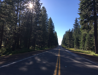
CA 89 is a 245 mile north/south highway which terminates at I-5 at it's north terminus and US 395 at it's southern terminus. The route of CA 89 lies completely within the Cascade and Sierra Nevada Ranges making it one of the most scenic highways in California. CA 89 is bisected by Lassen Volcanic National Park for which the park road acts as a seasonally open implied connection. My route on CA 89 started at CA 32 in Tehama County but I thought it would be more sensible to photograph it completely southbound from Lassen Volcanic National Park. Caltrans maintenance ceases at the National Park boundary which has a sign for Lassen Volcanic National Park.

Lassen Volcanic National Park is named after Lassen Peak a volcano 10,457 feet above sea level. Lassen Peak is a lava dome volcano and is the only site of an eruption aside from Mount St. Helens in the Continental United States in the 20th century. Lassen Peak had eruptions from 1914 to 1921 with the largest being in 1915 when it launched a cloud of ash that went close to 300 miles to the east. Lassen Peak and the surrounding area were once part of two National Monuments designated in 1907; Cinder Cone National Monument and Lassen Peak National Monument. Both monuments were combined into Lassen Volcanic National Park in 1916.

Unfortunately I was about a week too early to get too far in to Lassen as the park road was still shut down after only two miles northbound. There had been heavy amounts of snow in the winter but it seemed absurd the Park Service didn't have the road open to at least Lake Helen but late June.

But the Sulphur Works were completely available to see. The area was far more well signed to deter people from walking off into areas that have boiling water underneath them than back in 2014.


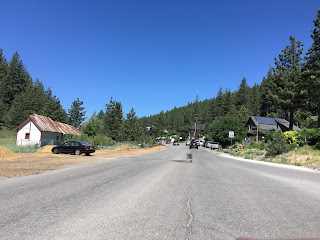
After touring the Sulphur works I rejoined CA 89 and took it to the junction with CA 36 at Morgan Summit. My photos are consecutive on southbound CA 89/eastbound CA 36 but this where I turned west on CA 36 to take the CA 172 album. Originally unnumbered Legislative Route 86 would have connected CA 89 to CA 36 to the west in Mineral. Morgan Summit along with nearby Fredonyer Pass are considered the boundary for the Cascade Range to the north and the Sierra Nevada Range to the south.

CA 89 South/CA 36 East multiplex eastward on what was LRN 83 and junction CA 172 at Mill Creek. My photo is looking back westward towards the climb to Morgan Summit.

LRN 83 once carried CA 89 from US 99 south to US 40 and was adopted in 1933. More information on LRN 83 can be found on CAhighways.org.
CAhighways.org on LRN 83
One more view of Lassen Peak from CA 89 North/CA 36 East at Gurnsey Creek.

CA 89 South/CA 36 East junction CA 32 near the Plumas County Line.


CA 89 South/CA 36 East continue east into Plumas County. CA 36 East breaks away from CA 89 as it traverses the north shore of Lake Almanor.


From the split with CA 36 East it is still 123 miles south to Truckee and Donner Pass Road on CA 89.

I stopped at Lake Almanor to take in the scenery from the side of CA 89. Lake Almanor is a large reservoir impounding the North Fork Feather River via use of Canyon Dam. Canyon Dam was originally completed in 1914 hence the reason the alignment of CA 89 largely follows the same route as it did back in 1934. Canyon Dam was expanded in the 1920s and 1960s to enlarge it's water storage capacity to about 1,300,000 acre feet.

There is still an older looking building which appears to be an old powerhouse near Canyon Dam. Canyon Dam is located on the south side of Lake Almanor and apparently owned by Pacific Gas & Electricity.

East of Lake Almanor CA 89 has a junction with CA 147.

CA 147 was created during the 1964 State Highway renumbering and was previously LRN 183. LRN 183 was adopted back in 1961 according to CAhighways.org and the current route of CA 147 from CA 89 north to CA 36 is only 12 miles.
CAhighways.org on CA 147
Greenville is only 9 miles to the southeast of the junction with CA 147 on CA 89.

Near the confluence of Sheepcamp Creek and Wolf Creek CA 89 crosses under a set of rails. CA 89 follows the north bank of Wolf Creek into Greenville.

It appears back when CA 89 was first signed that the highway crossed to the south bank of Wolf Creek and followed; Greenville-Wolf Creek Road, Setzer Road, and Main Street into Greenville. I'm unsure when the original alignment was replaced but it is fairly obvious the 1935 California Division of Highways map of Plumas County.
1935 Plumas County Map
Greenville has been around since the 1850s and lies within Indian Valley. I'd venture a strong guess than Greenville had some sort of connection to mining but I haven't been able to find a ton of documentation about it. CA 89 crosses through Greenville on Ames Street which is shown in the first picture. The second picture is on Main Street where CA 89 would have turned right on Ames Street originally.


CA 89 south continues through Indian Valley picking up the course of Indian Creek. CA 89 passes next through the small community of Crescent Mills. Crescent Mills was a small logging community which apparently dates back either to the late 1860s or early 1870s.


Quincy is only 17 miles to the south along CA 89, the junction with Signed County Route A22 is at Arlington Road. CR A22 continues 5 miles eastward to the community of Taylorsville.


CA 89 follows Indian Creek to downhill to CA 70/Feather River Highway.


CA 89 South multiplexes CA 70 East on the Feather River Highway towards Quincy. The Western Pacific Railroad is very obvious on CA 89 South/CA 70 East overhead.


As stated on the CA 70 blog CA 89 South/CA 70 East traverses Quincy on Crescent Street and One-way on Main Street through downtown. Both one-way alignments converse east of downtown heading towards East Quincy.


East of Quincy and East Quincy the city of Reno is signed as only 76 miles away.

Another look at the construction on the Estray Creek Bridge.

CA 89 near Blairsden cuts south off of CA 70, crosses underneath the Western Pacific Railroad, Middle Fork Feather River to a junction with CR A14. CR A14 continues 5 miles west to Plumas-Eureka State Park. On the 1935 Plumas County Highway Map I cited above CA 89 is shown using Bonita Street through Blairsden and Blairsden-Graeagle Road to cross the Middle Fork Feather River.


The old alignment of CA 89 over the Middle Fork Feather River has a nice steel truss bridge that I missed getting a picture of:
Google Image of Original CA 89 Middle Fork Feather River Crossing
CA 89 south next junctions CR A15 at Portola-Mclears Road. CR A15 continues about 8.4 miles to the east to CA 70 in Portola. Truckee is signed as 43 miles to the south on CA 89.


CA 89 south crosses into Sierra County and has a junction with CR A23 in Calpine. CR A23 continues about 12 miles north to CA 70 in Beckwourth.

CA 89 South meets CA 49 as it descends from Yuba Pass. Following CA 89 South leads to a strange reverse multiplex of CA 49 North in an easterly direction to Sierraville five miles ahead.


Turns out that I had it wrong on the CA 49 blog, for some reason CR 23 is signed at Westside Road in Sattley. The proper signage should say "To CR A23" as it officially begins at Calpine Road.

CA 89 splits south from CA 49 in Sierraville.


South of Sierraville the city of Truckee is signed as 25 miles to the south along with Lake Tahoe at 40 miles southward on CA 89.

CA 89 begins to climb southbound and enters Nevada County.

CA 89 used to continue through Hobart Mills into what is now the Prosser Creek Reservoir. The Prosser Creek Dam was constructed from 1959 to 1962 and Prosser Dam road is partially an original alignment of CA 89.

The shift off of Prosser Creek Road westward occurred some time in 1960 or 1961. The difference in CA 89 can be observed by comparing the two maps.
1960 State Highway Map
1961 State Highway Map
CA 89 hits a series roundabouts approaching I-80. At I-80 southbound traffic to Lake Tahoe is directed onto CA 267. CA 89 jumps onto I-80 and bypasses downtown Truckee. I stayed on the original CA 89 alignment on Donner Pass Road all the way up to the summit due to to the historic nature of the road associated with US 40.


CA 267 is a 13 mile state highway which continues south of CA 89 for 13 miles to CA 28 at Lake Tahoe. CA 267 was first defined in 1965 and first appears on the 1966 State Highway Map.
CAhighways.org on CA 267
1966 State Highway Map
I'll hit on US 40 over Donner Pass on the next blog and focus on the alignment history of CA 89 in Truckee for now. As stated above CA 89 was on Donner Pass Road through Truckee when it was original signed in 1935. This is reflected on the 1935 Nevada County Highway Map from the California Division of Highways.
1935 Nevada County Highway Map
I-80 through Truckee was constructed in pieces from the late 1950s through early 1960s. The freeway bypass of Truckee seems to have been completed by 1960 which likely meant US 40/CA 89 were routed onto it. The difference in route alignments can be observed by comparing the 1959 and 1960 State Highway Maps. I say "likely" in the case of CA 89 there is some odd signage north of I-80 on River Road which indicates that it stayed on Donner Pass Road far closer to modern times.
1959 State Highway Map
1960 State Highway Map
So with all that in mind US 40/CA 89 would have been routed through downtown Truckee. CA 89 would have split south from US 40 at River Road and continued south to Lake Tahoe. Truckee dates back to the creation of the First Transcontinental Railroad and apparently was once known as Coburn Station.


As I stated above I'm not sure when CA 89 really made the alignment shift off of Donner Pass Road. CA 89 is still signed from Donner Pass Road approaching River Road.

CA 89 from Truckee south to US 50 was part of LRN 38. More information on LRN 38 can be found on CAhighways.org.
CAhighways.org on LRN 38
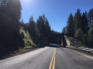
Continuing on CA 89 south from I-80 the highway crosses underneath the Transcontinental Railroad. The road tunnel in the second picture shows a construction time stamp of 1928 while the bike tunnel was constructed in 2015.


CA 89 crosses into El Dorado County and picks up the Truckee River approaching Lake Tahoe. Approaching CA 28 in Tahoe City the traffic became severe and my brakes actually started to fail. Unable to pull over I just kept my car in first gear give them opportunity to cool down. I would replace my entire brake system the following week as all the mountain driving from 2016 and 2017 necessitated full replacement of the rotors, calipers, in addition to the pads.


CA 28 is the second state highway to bear the number in California. The original CA 28 is now CA 128, the renumbering took place sometime in 1953-1954 to line up the modern CA 28 with NV 28 on the north shore of Lake Tahoe. The Current CA 28 was originally the unsigned LRN 39.


The switch from the original CA 28 to CA 128 and LRN 39 becoming the modern CA 28 can be seen by comparing the 1953/1954 State Highway Maps.
1953 State Highway Map
1954 State Highway Map
When I was at the junction I had no idea that the 1928 Fanny Bridge on CA 89 south of CA 28 was being replaced with a new modern routing over the Truckee River. The project is apparently supposed to be completed this year and details can be found at this website.
New Fanny Bridge Project Link
I continued on the western shore of Lake Tahoe towards Emerald Bay State Park. South Lake Tahoe was 27 miles away so I pulled over where I could to let my brakes cool down and take a break overlooking the lake.


I stayed on CA 89 to see Emerald Bay State Park. Emerald Bay is a cove on the south side of Lake Tahoe with high mountain sides which jut abruptly out of the water. CA 89 traverses Emerald Bay high above the waters and has some of the best sight lines of Lake Tahoe. The tiny island in the middle of Emerald Bay is called Fannette Island.


CA 89 on the eastern flank of Emerald Bay loops around Eagle Point. The road is high above Lake Tahoe which is mostly evident from the first picture appearing to drop straight into the waters below.


At Camp Richardson I had issues again with my brakes at a really poorly designed pedestrian crossing. Interestingly Fallen Leaf Road was once a state highway known as LRN 94 before the 1964 California State Highway renumbering and CA 188 after. LRN 94 was apparently adopted in 1933 but never became a signed state highway. Fallen Leaf Road is only four miles long and leads to the south shore of Fallen Leaf Lake. LRN 94/CA 188 was deleted in 1965 given it's unimportant status to the highway system. The history of LRN 94 and CA 188 can be found on CAhighways.org.
CAhighways on LRN 38
CAhighways on CA 188
The 1963 State Highway map shows LRN 94 on the south shore of Lake Tahoe.
1963 State Highway Map
The 1964 State Highway Map shows CA 188.
1964 State Highway Map
Interestingly CA 188 doesn't fall off state highway maps until 1967.
1966 State Highway Map
1967 State Highway Map
CA 89 has a junction with US 50 in South Lake Tahoe. I followed CA 89 South/US 50 West towards Echo Summit.


CA 89 is a 245 mile north/south highway which terminates at I-5 at it's north terminus and US 395 at it's southern terminus. The route of CA 89 lies completely within the Cascade and Sierra Nevada Ranges making it one of the most scenic highways in California. CA 89 is bisected by Lassen Volcanic National Park for which the park road acts as a seasonally open implied connection. My route on CA 89 started at CA 32 in Tehama County but I thought it would be more sensible to photograph it completely southbound from Lassen Volcanic National Park. Caltrans maintenance ceases at the National Park boundary which has a sign for Lassen Volcanic National Park.

Lassen Volcanic National Park is named after Lassen Peak a volcano 10,457 feet above sea level. Lassen Peak is a lava dome volcano and is the only site of an eruption aside from Mount St. Helens in the Continental United States in the 20th century. Lassen Peak had eruptions from 1914 to 1921 with the largest being in 1915 when it launched a cloud of ash that went close to 300 miles to the east. Lassen Peak and the surrounding area were once part of two National Monuments designated in 1907; Cinder Cone National Monument and Lassen Peak National Monument. Both monuments were combined into Lassen Volcanic National Park in 1916.

Unfortunately I was about a week too early to get too far in to Lassen as the park road was still shut down after only two miles northbound. There had been heavy amounts of snow in the winter but it seemed absurd the Park Service didn't have the road open to at least Lake Helen but late June.

But the Sulphur Works were completely available to see. The area was far more well signed to deter people from walking off into areas that have boiling water underneath them than back in 2014.


After touring the Sulphur works I rejoined CA 89 and took it to the junction with CA 36 at Morgan Summit. My photos are consecutive on southbound CA 89/eastbound CA 36 but this where I turned west on CA 36 to take the CA 172 album. Originally unnumbered Legislative Route 86 would have connected CA 89 to CA 36 to the west in Mineral. Morgan Summit along with nearby Fredonyer Pass are considered the boundary for the Cascade Range to the north and the Sierra Nevada Range to the south.

CA 89 South/CA 36 East multiplex eastward on what was LRN 83 and junction CA 172 at Mill Creek. My photo is looking back westward towards the climb to Morgan Summit.

LRN 83 once carried CA 89 from US 99 south to US 40 and was adopted in 1933. More information on LRN 83 can be found on CAhighways.org.
CAhighways.org on LRN 83
One more view of Lassen Peak from CA 89 North/CA 36 East at Gurnsey Creek.

CA 89 South/CA 36 East junction CA 32 near the Plumas County Line.


CA 89 South/CA 36 East continue east into Plumas County. CA 36 East breaks away from CA 89 as it traverses the north shore of Lake Almanor.


From the split with CA 36 East it is still 123 miles south to Truckee and Donner Pass Road on CA 89.

I stopped at Lake Almanor to take in the scenery from the side of CA 89. Lake Almanor is a large reservoir impounding the North Fork Feather River via use of Canyon Dam. Canyon Dam was originally completed in 1914 hence the reason the alignment of CA 89 largely follows the same route as it did back in 1934. Canyon Dam was expanded in the 1920s and 1960s to enlarge it's water storage capacity to about 1,300,000 acre feet.

There is still an older looking building which appears to be an old powerhouse near Canyon Dam. Canyon Dam is located on the south side of Lake Almanor and apparently owned by Pacific Gas & Electricity.

East of Lake Almanor CA 89 has a junction with CA 147.

CA 147 was created during the 1964 State Highway renumbering and was previously LRN 183. LRN 183 was adopted back in 1961 according to CAhighways.org and the current route of CA 147 from CA 89 north to CA 36 is only 12 miles.
CAhighways.org on CA 147
Greenville is only 9 miles to the southeast of the junction with CA 147 on CA 89.

Near the confluence of Sheepcamp Creek and Wolf Creek CA 89 crosses under a set of rails. CA 89 follows the north bank of Wolf Creek into Greenville.


It appears back when CA 89 was first signed that the highway crossed to the south bank of Wolf Creek and followed; Greenville-Wolf Creek Road, Setzer Road, and Main Street into Greenville. I'm unsure when the original alignment was replaced but it is fairly obvious the 1935 California Division of Highways map of Plumas County.
1935 Plumas County Map
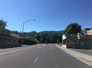
Greenville has been around since the 1850s and lies within Indian Valley. I'd venture a strong guess than Greenville had some sort of connection to mining but I haven't been able to find a ton of documentation about it. CA 89 crosses through Greenville on Ames Street which is shown in the first picture. The second picture is on Main Street where CA 89 would have turned right on Ames Street originally.


CA 89 south continues through Indian Valley picking up the course of Indian Creek. CA 89 passes next through the small community of Crescent Mills. Crescent Mills was a small logging community which apparently dates back either to the late 1860s or early 1870s.


Quincy is only 17 miles to the south along CA 89, the junction with Signed County Route A22 is at Arlington Road. CR A22 continues 5 miles eastward to the community of Taylorsville.


CA 89 follows Indian Creek to downhill to CA 70/Feather River Highway.


CA 89 South multiplexes CA 70 East on the Feather River Highway towards Quincy. The Western Pacific Railroad is very obvious on CA 89 South/CA 70 East overhead.


As stated on the CA 70 blog CA 89 South/CA 70 East traverses Quincy on Crescent Street and One-way on Main Street through downtown. Both one-way alignments converse east of downtown heading towards East Quincy.


East of Quincy and East Quincy the city of Reno is signed as only 76 miles away.

Another look at the construction on the Estray Creek Bridge.

CA 89 near Blairsden cuts south off of CA 70, crosses underneath the Western Pacific Railroad, Middle Fork Feather River to a junction with CR A14. CR A14 continues 5 miles west to Plumas-Eureka State Park. On the 1935 Plumas County Highway Map I cited above CA 89 is shown using Bonita Street through Blairsden and Blairsden-Graeagle Road to cross the Middle Fork Feather River.


The old alignment of CA 89 over the Middle Fork Feather River has a nice steel truss bridge that I missed getting a picture of:
Google Image of Original CA 89 Middle Fork Feather River Crossing
CA 89 south next junctions CR A15 at Portola-Mclears Road. CR A15 continues about 8.4 miles to the east to CA 70 in Portola. Truckee is signed as 43 miles to the south on CA 89.


CA 89 south crosses into Sierra County and has a junction with CR A23 in Calpine. CR A23 continues about 12 miles north to CA 70 in Beckwourth.
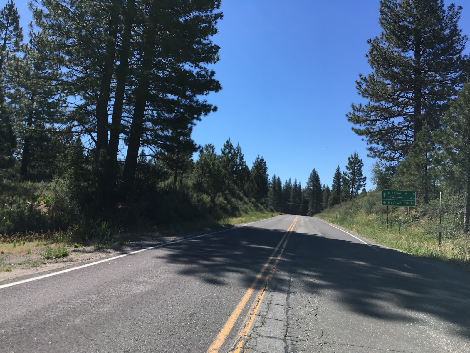

CA 89 South meets CA 49 as it descends from Yuba Pass. Following CA 89 South leads to a strange reverse multiplex of CA 49 North in an easterly direction to Sierraville five miles ahead.


Turns out that I had it wrong on the CA 49 blog, for some reason CR 23 is signed at Westside Road in Sattley. The proper signage should say "To CR A23" as it officially begins at Calpine Road.

CA 89 splits south from CA 49 in Sierraville.


South of Sierraville the city of Truckee is signed as 25 miles to the south along with Lake Tahoe at 40 miles southward on CA 89.

CA 89 begins to climb southbound and enters Nevada County.

CA 89 used to continue through Hobart Mills into what is now the Prosser Creek Reservoir. The Prosser Creek Dam was constructed from 1959 to 1962 and Prosser Dam road is partially an original alignment of CA 89.

The shift off of Prosser Creek Road westward occurred some time in 1960 or 1961. The difference in CA 89 can be observed by comparing the two maps.
1960 State Highway Map
1961 State Highway Map
CA 89 hits a series roundabouts approaching I-80. At I-80 southbound traffic to Lake Tahoe is directed onto CA 267. CA 89 jumps onto I-80 and bypasses downtown Truckee. I stayed on the original CA 89 alignment on Donner Pass Road all the way up to the summit due to to the historic nature of the road associated with US 40.


CA 267 is a 13 mile state highway which continues south of CA 89 for 13 miles to CA 28 at Lake Tahoe. CA 267 was first defined in 1965 and first appears on the 1966 State Highway Map.
CAhighways.org on CA 267
1966 State Highway Map
I'll hit on US 40 over Donner Pass on the next blog and focus on the alignment history of CA 89 in Truckee for now. As stated above CA 89 was on Donner Pass Road through Truckee when it was original signed in 1935. This is reflected on the 1935 Nevada County Highway Map from the California Division of Highways.
1935 Nevada County Highway Map
I-80 through Truckee was constructed in pieces from the late 1950s through early 1960s. The freeway bypass of Truckee seems to have been completed by 1960 which likely meant US 40/CA 89 were routed onto it. The difference in route alignments can be observed by comparing the 1959 and 1960 State Highway Maps. I say "likely" in the case of CA 89 there is some odd signage north of I-80 on River Road which indicates that it stayed on Donner Pass Road far closer to modern times.
1959 State Highway Map
1960 State Highway Map
So with all that in mind US 40/CA 89 would have been routed through downtown Truckee. CA 89 would have split south from US 40 at River Road and continued south to Lake Tahoe. Truckee dates back to the creation of the First Transcontinental Railroad and apparently was once known as Coburn Station.


As I stated above I'm not sure when CA 89 really made the alignment shift off of Donner Pass Road. CA 89 is still signed from Donner Pass Road approaching River Road.

CA 89 from Truckee south to US 50 was part of LRN 38. More information on LRN 38 can be found on CAhighways.org.
CAhighways.org on LRN 38
Continuing on CA 89 south from I-80 the highway crosses underneath the Transcontinental Railroad. The road tunnel in the second picture shows a construction time stamp of 1928 while the bike tunnel was constructed in 2015.


CA 89 crosses into El Dorado County and picks up the Truckee River approaching Lake Tahoe. Approaching CA 28 in Tahoe City the traffic became severe and my brakes actually started to fail. Unable to pull over I just kept my car in first gear give them opportunity to cool down. I would replace my entire brake system the following week as all the mountain driving from 2016 and 2017 necessitated full replacement of the rotors, calipers, in addition to the pads.


CA 28 is the second state highway to bear the number in California. The original CA 28 is now CA 128, the renumbering took place sometime in 1953-1954 to line up the modern CA 28 with NV 28 on the north shore of Lake Tahoe. The Current CA 28 was originally the unsigned LRN 39.


The switch from the original CA 28 to CA 128 and LRN 39 becoming the modern CA 28 can be seen by comparing the 1953/1954 State Highway Maps.
1953 State Highway Map
1954 State Highway Map
When I was at the junction I had no idea that the 1928 Fanny Bridge on CA 89 south of CA 28 was being replaced with a new modern routing over the Truckee River. The project is apparently supposed to be completed this year and details can be found at this website.
New Fanny Bridge Project Link
I continued on the western shore of Lake Tahoe towards Emerald Bay State Park. South Lake Tahoe was 27 miles away so I pulled over where I could to let my brakes cool down and take a break overlooking the lake.


I stayed on CA 89 to see Emerald Bay State Park. Emerald Bay is a cove on the south side of Lake Tahoe with high mountain sides which jut abruptly out of the water. CA 89 traverses Emerald Bay high above the waters and has some of the best sight lines of Lake Tahoe. The tiny island in the middle of Emerald Bay is called Fannette Island.


CA 89 on the eastern flank of Emerald Bay loops around Eagle Point. The road is high above Lake Tahoe which is mostly evident from the first picture appearing to drop straight into the waters below.


At Camp Richardson I had issues again with my brakes at a really poorly designed pedestrian crossing. Interestingly Fallen Leaf Road was once a state highway known as LRN 94 before the 1964 California State Highway renumbering and CA 188 after. LRN 94 was apparently adopted in 1933 but never became a signed state highway. Fallen Leaf Road is only four miles long and leads to the south shore of Fallen Leaf Lake. LRN 94/CA 188 was deleted in 1965 given it's unimportant status to the highway system. The history of LRN 94 and CA 188 can be found on CAhighways.org.
CAhighways on LRN 38
CAhighways on CA 188
The 1963 State Highway map shows LRN 94 on the south shore of Lake Tahoe.
1963 State Highway Map
The 1964 State Highway Map shows CA 188.
1964 State Highway Map
Interestingly CA 188 doesn't fall off state highway maps until 1967.
1966 State Highway Map
1967 State Highway Map
CA 89 has a junction with US 50 in South Lake Tahoe. I followed CA 89 South/US 50 West towards Echo Summit.


CA 89 splits away from US 50 to head south towards CA 88 via the 7,740 foot Luther Pass. Interestingly CA 89 used to take Upper Truckee Road and an abandoned dirt road south of Luther Pass to reach what is now CA 88. The alignments can be seen on the 1935 California Division of Highways Map of El Dorado County. I split west on US 50 towards Echo Summit and the western flank of the Sierras. This particular trip was a clinched the entirety of CA 89 or me as I had driven the rest of the highway in 2014 and 2016.
Comments