Since 1935 the Tower Bridge has served as a major crossing of the Sacramento River between the cities of Sacramento and West Sacramento. The structure was built as a replacement of the M Street Bridge and originally was part of US Routes 40 and 99W. By the late 1950s it would become the eastern terminus of the West Sacramento Freeway.
Following the completion of Interstate 80 through downtown in 1967 Sacramento the Tower Bridge would become part of California State Route 275. Despite California State Route 275 being deleted by the Legislature in 1996 the Tower Bridge never was relinquished. This relinquishment failure led to California State Route 275 being revived in 2010 comprising of only 0.14 miles of roadway. California State Route 275 and the Tower Bridge currently comprise the shortest State Highway in the Caltrans inventory.
Part 1; the history of the Tower Bridge
The emergence of the automobile in the early 20th Century led to the 1909 First State Highway Bond Act which was approved by voters during 1910. The majority of the highways approved as part of the First State Highway Bond Act were largely well-established routes of travel. At the time First State Highway Bond Act was passed the State could not maintain highway mileage within incorporated cities.
The western entrance to Sacramento was originally served by
Legislative Route Number 6. The original 1909-era definition of this highway comprised two segments:
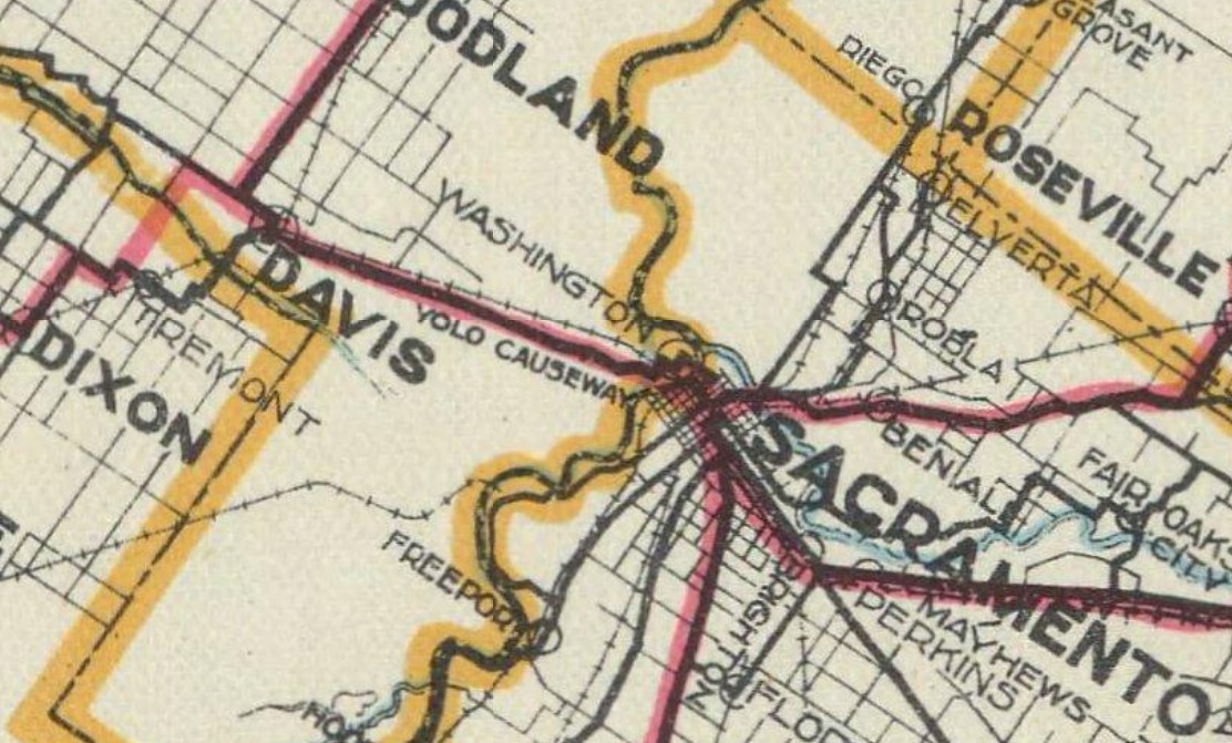
1. Sacramento to Woodland Junction.
2. Legislative Route Number 8 near Napa to Winters via Wooden Valley and Berryessa Valley.
From Sacramento early Legislative Route Number 6 can be seen departing the city westward via the I Street Bridge to Washington (now West Sacramento) on the 1917 California State Automobile Association Map. The I Street Bridge opened to traffic over the Sacramento River in 1912 as a swing span carrying the Southern Pacific Railroad and highway traffic.

The July 1916 California Highway Bulletin features the completed Yolo Causeway (referred to as the Yolo Basin Trestle) between West Sacramento and Davis. The dedication ceremony celebrating the opening the Yolo Causeway took place from May 11-14, 1916. The Yolo Basin is described as being a historically difficult area to traverse overland due to it being flooded six to eight months every year. Prior to the construction of the Yolo Causeway a primitive seasonal road known as "Tule Jake Road" could be utilized to traverse Yolo Basin by car between West Sacramento and Davis. Note: upon the completion of the Carquinez Bridge in 1927 the Lincoln Highway was realigned over the Yolo Causeway.
The Yolo Causeway article in the 1916 California Highway Bulletin shows Legislative Route Number 6 was realigned from the I Street Bridge to the M Street Bridge in West Sacramento. This realignment would have eliminated a rail overpass from the alignment.
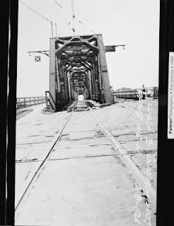
The M Street Bridge was originally constructed as a railroad swing structure in 1911. Originally the was utilized by the Sacramento North Railway, Oakland Antioch & Eastern Railway and Northern Electric Railway. The construction of Legislative Route Number 6 and the Yolo Causeway saw roadway lanes added to the M Street Bridge as part of the realignment of the highway. The photos below are hosted by bridgehunter.com and were taken when the M Street Bridge was being replaced by the Tower Bridge during 1934.


During November 1926 the US Route System was commissioned by the American Association of State Highway Officials (AASHO). As the system was originally configured both US Route 40 and US Route 99 entered Sacramento via the M Street Bridge. This multiplex can be seen on the
1927 National Map Company paved road map of California.

The February 1927 California Highways & Public Works featured the recently completed M Street Bridge approach in West Sacramento along with the new alignment of US Routes 40 and 99 through the 1926 Sacramento Northern Railroad Subway.
The AASHO data base has information pertaining to a request made by the California State Highway Engineer to have US Route 99 become a split route between Red Bluff south to Sacramento. In a letter dated June 13, 1928, the rationale for splitting US Route 99 into an East/West routing was a two-to-one traffic ratio on Legislative Route Number 3 on the east bank of the Sacramento River compared to Legislative Route Number 7 on the west bank.
The proposed US Route 99W/99E split can be seen for the first time on this map (which was scanned upside down in the AASHO database).
The US Route 99W/99E split from Red Bluff to Sacramento was approved by the AASHO on August 6, 1928.
The first map to display US Route 99 as a split route south of Red Bluff towards Sacramento can be seen on the 1930 Division of Highways State Map. US Route 99W is shown multiplexing US Route 40 into Sacramento via the M Street Bridge.
In 1933 the restrictions preventing the Division of Highways from formally owning and maintaining highways within cities was removed by the Legislature. This action it made it far easier to replace the then already obsolete M Street Bridge.
The
January 1936 California Highways & Public Works featured the opening of the Tower Bridge on December 15, 1935. The Tower Bridge was a direct replacement for the previous M Street Bridge which existed on the same location. During the process of construction of the Tower Bridge the M Street Bridge was removed which had US Routes 40 and 99W cross the Sacramento River via a temporary structure. Unlike the swing design of the M Street Bridge the design of the Tower Bridge features a vertical lift span. The Tower Bridge was originally silver in color when the structure was complete.
The
July/August 1954 California Highways & Public Works cites the West Sacramento Freeway as opening on June 15, 1954, in an article pertaining to the expansion of US Route 40. The article states the West Sacramento Freeway was designed with future provisions to build an additional bridge over the Sacramento River so US Routes 40 and 99W which would serve as a full bypass of downtown Sacramento. The West Sacramento Freeway had an eastern terminus at the Tower Bridge.
The
1955 Division of Highways map displays the West Sacramento Freeway terminating the Tower Bridge. The then new freeway replaced what is now Capital Avenue in West Sacramento.
On June 29, 1956, the Federal Highway Aid Act of 1956 was signed into law on the Federal Level. The Federal Highway Aid Act of 1956 was the genesis point of the Interstate Highway System. This would be the genesis point which would see US Routes 40 and 99 eliminated in California in the coming decade.
The
July/August 1961 California Highways & Public Works displays the adopted freeway alignment of US Routes 40, US Route 99 and Interstate 80 through Sacramento. The West Sacramento Freeway to the Tower Bridge was planned from this point to be retained as a funnel towards the State Capitol grounds. The last train to crossing of the Tower Bridge would occur in 1962. The tracks were removed from the structure in 1963.
As part of the run up to the 1964 State Highway Renumbering US Route 40 was eliminated in California. Signage was to remain in place along segments of the highway which had not been yet bypassed by Interstate 80. Given that Interstate 80 in Sacramento had not been completed the Tower Bridge by default was legislatively assigned as part of Route 80. US Route 99 would be truncated to Oregon during June 1965 but was partially replaced with what is now California State Route 99.


1967 Legislative Chapter 1350 defined
California State Route 275 as:
"Route 80 near West Acres Road west of Sacramento to the junction of Capitol Avenue and Ninth Street in Sacramento."
Essentially the definition of California State Route 275 consisted of the segment of former US Routes 40 and 99W from Interstate 80 along the West Sacramento River Freeway east over the Tower Bridge towards the State Capitol (along Capitol Mall). The initial alignment of California State Route 275 can be seen on the
1967 Division of Highways State Map.
In 1977 the Tower Bridge was repainted to the color golden ochre. California State Route 275 was deleted from the State Highway System by 1996 Legislative Chapter 1154. The former parts of US Routes 40 and 99W on the West Sacramento Freeway from the Tower Bridge to US Route 50 was converted to Tower Bridge Gateway and relinquished to the City of West Sacramento. The highway segment along Capitol Mall east from the Tower Bridge to 9th Street was relinquished to the City of Sacramento.
An agreement to relinquish the Tower Bridge itself was never reached. Subsequently
California State Route 275 was reactivated via 2010 Legislative Chapter 421 which solely consisted of the Tower Bridge. The Tower Bridge is the shortest State Highway in California at 0.14 miles. A 2020 proposal called for an eventual extension of SacRT light rail over the structure.
Part 2; exploring the Tower Bridge
The Tower Bridge and California State Route 275 are 737 feet (0.14 miles) in length and carry four lanes of traffic over the Sacramento River. The vertical lift design has a 100-foot clearance above the high-water mark of the Sacramento River.
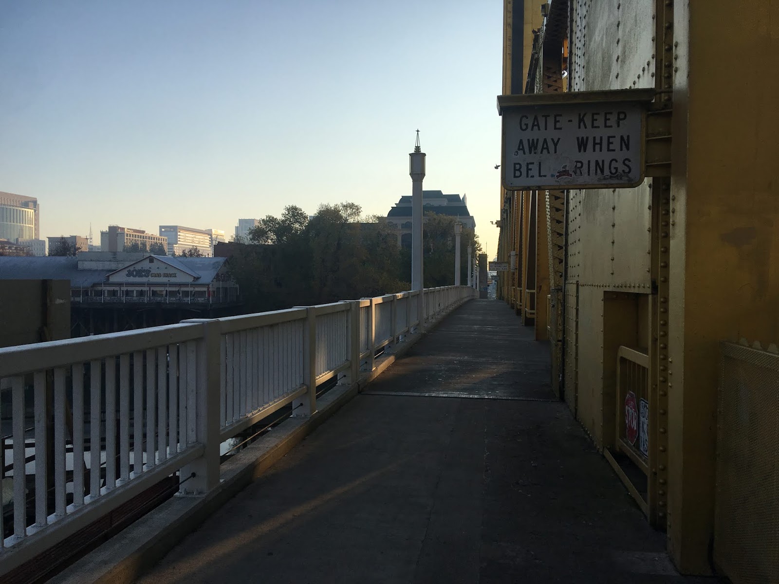
Crossing Capitol Mall at the eastern foot of the Tower Bridge offers an impressive view of the road deck to the west and the State Capitol ten streets to the east.
Heading west along the eastbound lanes of the Tower Bridge offers a view south on Sacramento River towards US Route 50. There are various signs on the Tower Bridge alerting pedestrian traffic to get off the lift span when the bell from the control station rings.
Looking east towards the Tower Bridge it is hard to envision it as the eastern terminus of the West Sacramento Freeway.
The westbound lanes of the Tower Bridge offer a northward view of the I Street Bridge.
On the south side of the Tower Bridge along the Sacramento River Bike Trail there are several historical placards detailing the history of the structure. There is a historical placard regarding the 1911 M Street Bridge
From the south side of the Tower Bridge a sign stating the operating hours for the control bridge can be observed. The lift span is surprisingly operated by only two 100hp electric motors.


Comments