On the Allegheny County Belt Route System, as you get closer to the bottom of the rainbow, you get closer to Downtown Pittsburgh. So, with the Green Belt, you begin to move closer to the inner suburbs, and for a brief moment or two, within the limits of the City of Pittsburgh. With this, I had expected to travel through some of the higher-density neighborhoods and communities surrounding the city. As I drove through the hollows and cut across the North Hills, I did not expect the scenery of the Green Belt to closely resemble its name.
 |
| Take your pick! Two different Green Belt signs along PA 837 in Duquesne. |
The Green Belt, for most of its nearly 40-mile arc around the eastern and northern city limits of Pittsburgh, offered far more "green" than you'd expect.
The Route:
The Green Belt runs a 2/3 loop around the eastern, northern, and northwestern communities that border the City of Pittsburgh. Since it is not a full loop, there is a definite beginning and end to the route. For this trip, I started with the terminus closest to me, the Duquesne-McKeesport Bridge.
 |
| The Green Belt crosses the Monongahela River on the nearly 100-year-old Duquesne-McKeesport Bridge. |
The Green Belt begins on the McKeesport side of the nearly 100-year-old bridge. However, if you don't know that this is the start of the Green Belt, it would be easy to miss. Yes, there is a sign for the Green Belt not long before the ramp onto the bridge, but an arrow or 'Next Right' sign is missing. The first Green Belt reassurance marker isn't until after you cross the bridge.
 |
| The timeless Kennywood arrow points you to Kennywood Amusement Park, the largest attraction on the Green Belt. |
In 1974, Green Belt was extended south along PA 837 and the Duquesne-McKeesport Bridge from the Rankin Bridge. As a result, the Green Belt now passes Kennywood Amusement Park. With Kennywood being one of the major attractions in the Pittsburgh Area, my thinking is that the Green Belt extension (along with the timeless Kennywood arrows) would help drivers navigate the eastern suburbs to the park.
 |
| The Green Belt crosses the Monongahela River again this time via the Rankin Bridge. Keep your eyes open, as you want to be in the left lane of PA 837 North to cross over the bridge and remain on the Green Belt. |
Once across the Rankin Bridge, the Green Belt travels through the dense East Hills communities of Braddock, Rankin, Swissvale, Edgewood, and Wilkinsburg. Here, the Green Belt moves along Braddock, Swissvale, and Edgewood Avenues into Wilkinsburg. Not every turn is well signed, however.
 |
| The corner of Edgewood and Swissvale Avenues is a great stop and explore point along the Green Belt. |
Edgewood is a great stop along the Green Belt route. At the corner of Edgewood and Swissvale Avenues, the former Edgewood Train Station sits. Park here, stop at Spigolo Coffee Shop (a former gas station), enjoy the pollinator garden at Memorial Park, or walk under the East Busway and Railroad to Pennwood Avenue and the CC Mellor Memorial Library.
 |
| The Green Belt through Wilkinsburg. |
The Green Belt continues on Swissvale Avenue into Wilkinsburg. A few of the turns aren't well marked as you transition from Swissvale Avenue and Park Avenue onto Montier Street. While the turns aren't well marked at Park Avenue, follow the flow of the main traffic, and you'll be fine.
 |
| The tree-filled Allegheny River Boulevard. |
Once the Green Belt leaves Wilkinsburg via Montier Street and Robinson Boulevard, the dense commercial and residential neighborhoods of the East Hills quickly transition to green as the route takes Verona Road down to PA 130 and Sandy Creek/Coal Hollow Road. Not long after, the Green Belt turns left to follow the tree-lined Allegheny River Boulevard towards Highland Park.
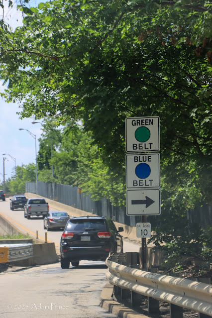 |
| Feast your eyes on a rarity: two belt routes signed together. Here, the Blue and Green Belts are leaving PA 8 to cross the Allegheny River via the Highland Park Bridge. |
Highland Park and the Highland Park Bridge are where the only concurrency of two Allegheny County Belt Routes occurs. Here, the Blue Belt meets the Green Belt, travels across the Highland Park Bridge, and then heads south on the PA 28 freeway while the Green Belt heads north on PA 28. The Green Belt stays on PA 28 for about a mile before leaving the highway at Exit 8 and onto Fox Chapel Road.
After a brief run on PA 8, a right turn (again unsigned) puts you on Duncan Avenue towards McKnight Road. I missed the turn onto Peebles Road at Allegheny Memorial Park near LaRoche University. The Green Belt crosses McKnight Road at Peebles Road. The retail centers of McIntyre Square and The Block Northway (the old Northway Mall) border the intersection.
 |
| Babcock Trading Company is a great place to visit while you explore the Green Belt. |
The Green Belt descends into the valley between McKnight Road and Perry Highway, where Girtys Run flows. At the intersection of Babcock Boulevard and Three Degree Road, the
Babcock Trading Company, an antique store, is worth the stop. The antique shop specializes in Americana-type antiques, and you can find countless gas station, beer, sports team, and other similar treasures.
 |
| It never fails - I have encountered a portion of a belt route closed due to construction on all three of my trips. Will the Blue or Red Belt be the same? Stay tuned! |
Climbing the ridge out of the valley to Perry Highway, the Green Belt then heads downhill again towards Lowries Run. Along here, the Green Belt curves along the run following Lowries Run and Camp Horne Roads until the Green Belt finally ends at PA 65/Ohio River Boulevard in Emsworth.
 |
| The unceremonious and unsigned end of the Green Belt at PA 65/Ohio River Boulevard in Emsworth. |
All photos taken by the post author - June 29, 2025.
Conclusion:
Maybe since it is not a full loop, the Green Belt lacked an overall purpose to me. Outside of Kennywood and possibly Hartwood Acres, it did not really connect or route you to any major destinations. At best, the Green Belt is a mix-and-match of various roads that happen to carry a designation.
Like the two belt routes I have traveled before, the Green Belt showcased to me areas of Allegheny County I am, or was, not very familiar with. Compared to the Orange Belt, the Green Belt's shorter length didn't leave me frustrated. But unlike the Yellow Belt, I didn't find much value in even general segments of the route. Is it because it is not a full loop and avoids the older, denser South Hills?
Outside of the East Hills communities, I was quite surprised by how less densely populated the areas most of the Green Belt meandered through were. The 'greenness' of the Green Belt was a pleasant surprise.
And of course, the lack of signage again makes using the Green Belt, or any of the belts, a useful navigation aid. I still have two more belts to explore, Blue and Red, but right now the Green Belt seems to be the most unnecessary of the bunch.
Site Navigation:
Further Reading:
Sources & Links:


Comments