1882 Station Road Bridge and 1931 Brecksville-Northville High Level Bridge (Ohio State Route 82 in Cuyahoga Valley National Park)

The Station Road Bridge and Brecksville-Northville High Level Bridge are historic alignments of Ohio State Route 82 over the Cuyahoga River in Pinery Narrows. The Station Road Bridge is an iron truss span which was opened to traffic 1882. The Brecksville-Northville High Level Bridge as an arch span which opened in 1931. The Station Road Bridge was added to the National Register of Historic Places in 1978 and is now part of trailhead in Cuyahoga Valley National Park.
Part 1; the history of the Station Road Bridge and Brecksville-Northville High Level Bridge
Both the Station Road Bridge and Pinery Narrows Bridge span the Cuyahoga River in near the site of Brecksville Station in Cuyahoga Valley National Park. Both spans are located in Pinery Narrows which is the slimmest point in Cuyahoga Valley.
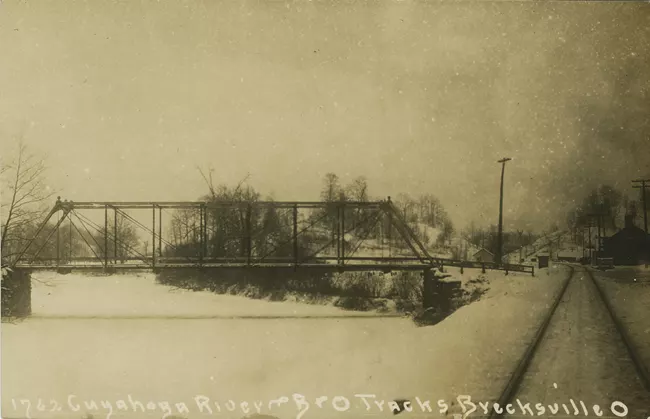
During 1880 Valley Railway service began which included a stop at Brecksville on the western banks of Cuyahoga River. During 1881 the Station Road Bridge (an iron truss design) was constructed which connected Station Road over the river to Pine Hill Road. The structure was not opened until 1882 with speculation being that a dedication ceremony was held up awaiting warmer weather.
The Station Road Bridge can be seen facing south from the Valley Railway in a National Park Service photo.
The Station Road Bridge (blue pin) can be seen on the 1903 United States Geological Survey map of Cleveland.

During 1924 Ohio State Route 82 was commissioned between Strongsville and Masury. The then new State Highway initially crossed the Cuyahoga River via the Station Road Bridge. The highway appears on the 1927 Rand McNally Junior Map of Ohio.

During 1931 the Brecksville-Northville High Level Bridge was constructed north of the Station Road Bridge. The then new 1,132-foot-long deck arch span permitted the realigned Ohio State Route 82 to cross the Cuyahoga River and Pinery Narrows at a level grade via Chippewa Road.
The modern alignment of Ohio State Route 82 over Pinery Narrows appears in detail on the 1953 United States Geological Survey map of Northfield.

During December 1974 Cuyahoga Valley National Recreation Area was declared. The Station Road Bridge was added to the National Register of Historic Places in 1978. The structure deteriorated to such an extent that it was closed to vehicle traffic in 1980. The span was disassembled in 1991 and sent to New York to be restored.
Ultimately the Station Road Bridge would be reinstalled during August 1992 as a pedestrian bridge. The bridge is mostly used currently to access the Ohio & Erie Canal Towpath Trail.
Part 2; visiting the Station Road Bridge and Brecksville-Northville High Level Bridge
The Station Road Bridge can be access from Riverview Road by turning east on Station Road.


The Station Road Bridge is a short walk from Brecksville Station.


The Station Road Bridge still has a plaque noting it was constructed by Massillon Bridge Company.

The Brecksville-Northville High Level Bridge can be seen from the Station Road Bridge facing north into Pinery Narrows.


From Station Road the Brecksville-Northville High Level Bridge can be accessed by following Riverview Road north and Ohio State Route 82 east.


Comments