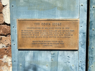
Calaveritas Road is a five-mile mountain highway in the Sierra Nevada Mountains of Calaveras County, California. Calaveritas Road connects from Mountain Ranch Road in San Andreas southeast to Dogtown Road by way of the Gold Rush community of Calaveritas. Calaveritas was founded in 1849 by Mexican miner and is the location where the ruins of the Costa Store can be found. The Calaveritas Creek Bridge can be found on Calaveritas Road and is the oldest example of a top chord Warren pony truss in California having been constructed during 1928.
Part 1; the history of Calaveritas Road
Calaveritas Road is named after the small community of the same name located southwest of San Andreas. Calaveritas was founded by Mexican miners in 1849. The community is thought to have peaked with a population of about 800 by 1857. Much of Calaveritas would burn in a fire during 1858 which would lead to it declining. For a time, the community as known as "Upper Calaveritas" to differentiate it from a nearby "Lower Calaveritas."
Calaveritas Road can be seen connecting San Andreas to the vicinity of Indian Creek via Calaveritas on the 1914 C.F. Weber Map of Calaveras County.
The Calaveritas Creek Bridge is located just south of the namesake community along Calaveritas Road. The structure is a top chord Warren pony truss which was constructed during 1928. The structure was found to be oldest remaining such design left in California during a study in 2015 (Calaveras Enterprise). The structure was added to the National Register of Historic Places during August of said year.
Part 2; a drive on Calaveritas Road
Calaveritas Road begins in San Andreas at Mountain Ranch Road.
As southbound Calaveritas Road begins traffic is warned of the 18,000-23,000lb weight limit four miles ahead at the Calaveritas Creek Bridge.
Calaveritas Road continues south as a two-lane road and drops to a single lane approaching the Cement Plant Road trestle.
The Cement Plant Road trestle was built over Calaveritas Road in the late 1920s by Calaveras Cement. Calaveras Cement incorporated in 1925 and was based out of a plant located on Pool Station Road. The company is most well-known for supplying cement to the construction site of Pardee Dam. The company would construct a 5.5-mile private road from their plant to quarries located east of Calaveritas. Calaveras Cement would be sold in 1959 and again in 1979. The company would be shuttered in 1983 due to being unable to compete with foreign cement prices and a high cost to modernize their plant. Despite the shuttering of Calaveras Cement the road to the quarry remains private and inaccessible to the public.
Calaveritas Road passes through the town site of Calaveritas. The remains of the Costa Store constructed in 1852 harkens back to the era of the Gold Rush. The Costa Store operated in the community into the early twentieth century. A State Registered Landmark plaque can also be found in the community.
Calaveritas Road continues south over the Calaveritas Creek Bridge.
Calaveritas Road climbs from Calaveritas Creek and terminates at Dogtown Road.


Comments