
Thousand Palms Canyon Road


Thousand Palms Canyon Road is a four-mile highway which is located in Indio Hills of Riverside County.  Thousand Palms Canyon Road is named after the Thousand Palms Oasis which is home to a grove of Californian Palms.  Thousand Palms Canyon Road begins at the intersection of Washington Street/Ramon Road and ends at Dillon Road.  


Part 1; the history of Thousand Palms Canyon Road

Thousand Palm Canyon Road lies in a fold in the Indio Hills which is filled with native Californian Palm Trees (Washingtonia filifera).  The Californian Palm Trees of the Indio Hills grow in lands which water is pushed to the surface by the nearby San Andreas Fault.  The Indio Hills are home to the Thousand Palm Oasis of the Coachella Preserve for which Thousand Palm Canyon Road is named.

Thousand Palms Canyon Road was constructed as a haul road to the Colorado River Aqueduct site north of the Indio Hills.  The Colorado River Aqueduct spans 242 miles from Parker Dam on the Colorado River west to Lake Mathews near Corona.  Construction of the Colorado River Aqueduct began during January 1933 near Thousand Palms and was made functional on January 7, 1939.

The intersection of Thousand Palms Canyon Road and Dillon Road can be seen in a photo dated to 1934 (courtesy Carl Schulz).  A sign can be seen directing traffic to Thousand Palms Camp.  Thousand Palms Camp was developed during the 1930s by Paul Wilhelm.  Wilhelm constructed the cabin which is now the headquarters of the Coachella Preserve.  


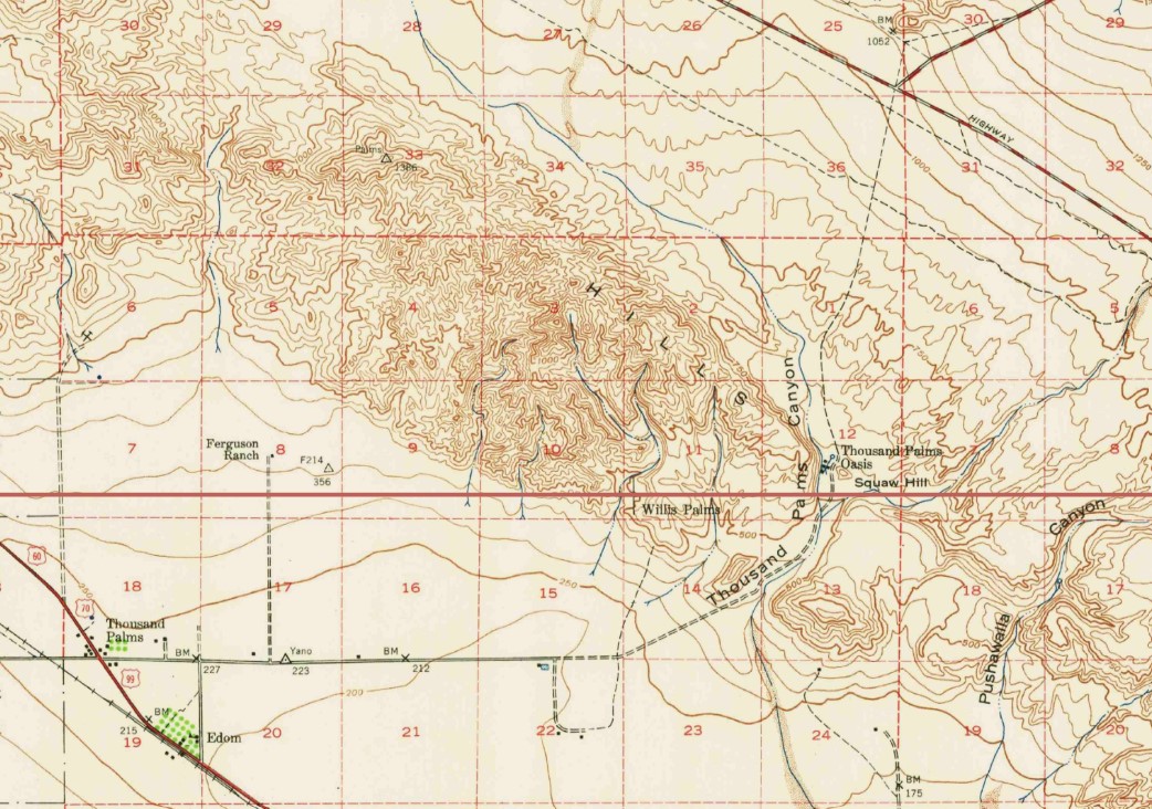
Thousand Palms Canyon Road and the Thousand Palms Oasis can be seen on the 1944 United States Geological Survey Map of Edom.  


The Coachella Preserve as it is known today was created during 1986 and is managed by the Centers for Natural Lands Management.  


Part 2; a drive on Thousand Palms Canyons Road

Thousand Palms Canyon Road northbound begins via a right-hand turn from Washington Street.  


As northbound Thousand Palms Canyon Road begins the Willis Palms Trail and grove can be seen. 


Northbound Thousand Palms Canyon Road passes by the Coachella Valley Visitor Center.  


Northbound Thousand Palms Canyon Road terminates at Dillon Road.  Thousand Palms Canyon Road sometimes appears on older United States Geological Survey maps continuing north of Dillon Road to mining claims at Fan Hill near the boundary of Joshua Tree National Park. 


Comments

Popular posts from this blog

Bleriot Ferry - Alberta

  Alberta operates six ferries scattered throughout the province. Roughly twenty to twenty-five kilometers up the Red Deer River from the town of Drumheller is one of the most scenic ferry crossings in all of Wild Rose Country, the Bleriot Ferry. Using the North Dinosaur Trail (Alberta Highway 838, or AB 838), the Bleriot Ferry provides a scenic river cruise of sorts in the Canadian Badlands. The Bleriot Ferry started operating in 1913 as the Munson Ferry when a few bridges crossed the Red Deer River. The ferry was started by Andre Bleriot, the brother of famed early aviator Louis Bleriot, who became famous for being the first person to fly over the English Channel. At the time, the Alberta provincial government commissioned local residents to run the ferries. There were several ferries along the Red Deer River, and not only did they serve as vital transportation links, but they also served as local social hubs, since everyone had to take the ferries to go places. Over time, as the...

The Pollasky Bridge

The Pollasky Bridge near modern day Friant is a ruined highway bridge which was completed during early 1906 as part of the Fresno-Fresno Flats Road.  The structure is one of the oldest known arch concrete spans to have been constructed in California.  The bridge briefly carried California State Route 41 following the destruction of the Lanes Bridge in 1940.  The Pollasky Bridge itself was destroyed by flooding during 1951, but the ruins can still be found on the Madera County side of the San Joaquin River.   Pictured as the blog cover is the Pollasky Bridge as it was featured in the 1913 book "The Concrete Bridge."  The structure can be seen crossing the San Joaquin River near Friant below on the 1922 United States Geological Survey Map.   Part 1; the history of the Pollasky Bridge The Pollasky Bridge site is near modern day Friant of Fresno County.  The community of Friant was established as Converse Ferry during 1852 on the San Joaquin Rive...

Trimmer Springs Road (Fresno County)

Trimmer Springs Road is an approximately forty-mile rural highway located in Fresno County.  The corridor begins near in California State Route 180 in Centerville and extends to Blackrock Road at the Kings River in the Sierra Nevada range near the Pacific Gas & Electric Company town of Balch Camp. The roadway is named after the former Trimmer Springs Resort and was originally constructed to facilitate access to the Sanger Log Flume.  Trimmer Springs Road was heavily modified and elongated after construction of Pine Flat Dam broke ground in 1947.   Part 1; the history of Trimmer Springs Road Much of the original alignment of Trimmer Springs Road was constructed to facilitate access to the Sanger Log Flume.   The  Kings River Lumber Company  had been established in 1888 in the form of a 30,000-acre purchase of forest lands in Converse Basin.  This purchase lied immediately west of Grant Grove and came to be known as "Millwood."  The co...