
Raleigh and Durham, North Carolina. Two cities - roughly twenty miles apart. Both are growing, have their own identity, and a little bit of a rivalry. The major international airport is Raleigh-Durham, but don't tell anyone from Raleigh or Durham that they are the same city.
There are a variety of different yet similar things in both cities. One example is two separate bridges - both carry trains, eat trucks annually, and are beloved in their unique way.
Raleigh's Peace Street Bridge and Durham's Can Opener Bridge (located at South Gregson at West Peabody) are both low-clearance Norfolk Southern railroad overpasses that for decades have taken out numerous unsuspecting tractor-trailers. Each bridge resides near their respective city's downtowns - Durham's Brightleaf District and Raleigh's Glenwood South. Over the years, the two bridges have generated media attention and a social media following.
Durham's Can Opener Bridge:

The bridge opened in 1940 carrying the Southern Railway over Gregson Street. Today, the tracks remain in operation with Durham's Amtrak Station a few hundred yards to the southeast. Initially built with a clearance of 11 feet and 8 inches, the Gregson Bridge had a well-known and earned reputation as a truck eater by the late 1960s.
The bridge became a local and later worldwide celebrity in 2008. A local professional, Jürgen Henn, placed a video camera in his Brightleaf Square office to record traffic. A few weeks later, he captured his first crash. A year later, he added a second camera. A YouTube channel was created - the videos were so successful that Henn created a website documenting the bridge's mishaps. In addition, you can buy bridge merchandise.
 |
| Durham's formerly 11'8" Gregson Street Bridge now has a 12'4" clearance. |
It wasn't until 2019 that the Gregson Street Bridge saw clearance improvements. A $500,000 safety improvement allowed transportation officials to raise the Gregson Street Bridge another eight inches to a 12-foot-4-inch clearance.
Raleigh's Peace Street Bridge:
The Gregson Street Bridge clearance now matches the clearance of the other Triangle truck-scalping bridge, Raleigh's Peace Street Bridge. The 12'4" low-clearance bridge is the second rail bridge to sit just east of the Glenwood Ave. and Peace St. intersection.
 |
| Raleigh's Peace Street Bridge - the current version has been in place since 1963. (Adam Prince - September 2023) |
The first Peace Street Bridge was a basic plate girder design erected in 1948 that carried over the Southern, now Norfolk Southern, Railway at a 12-foot clearance. That bridge was replaced in 1963 by the current bridge. When completed clearance was only improved by 4".
Annually since then, the bridge has claimed its share of 18-wheelers, moving trucks, and more. The bridge is a staple of Raleigh social media - and has its 'own' Twitter account.
Tale of the Tape:
Both bridges are local community iconic landmarks. So how do they measure up against each other?
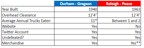 |
| * - Number calculated from 11foot8 data of 178 trucks over 15 years. ** - Raleigh Peace Street Bridge merchandise is done by a local clothing company. |
The Peace Street Bridge does NOT, to my knowledge, have an active webcam that monitors the bridge and then has any incidents shared online.
In the end, the victory goes to Durham. The bridge's video documentation and internet presence are far greater than its feisty neighbor down the line in Raleigh.
Further Reading:
- Big trucks beware: Rural NC bridge devours more trucks than Can-Opener, Peace Street combined ---WRAL-TV
Sources & Links:
Comments