US Route 60 officially entered California in 1931 following the purchase of the Colorado River Bridge near Blythe. US Route 60 was truncated to US Route 95 in Blythe in October 1965 as the Interstates of California were being constructed. Following the completion of Interstate 10 in California, the final removal of US Route 60 in the state was overlooked. This oversite allowed US Route 60 to officially terminate in Blythe at US Route 95 on AASHTO logs until 1982. Featured as the blog cover photo is the original Colorado River Bridge near Blythe as it was upon opening in 1928.
Part 1; how US Route 60 made a final stand in California by remaining in Blythe until 1982
The Mecca-Blythe Highway was the primary driver for US Route 60 to be eventually extended into California.
Legislative Route Number 64 (LRN 64) was defined by the 1919 Third State Highway Bond Act as a new State Highway from Mecca to Blythe. The general routing of LRN 64 was different from the Bradshaw Trail as it followed Box Canyon, Chiriaco Summit, and Chuckwalla Valley. The general routing of LRN 64 appears for the first time on the
1920 California Highway Commission Map.
The
March 1925 California Highways & Public Works features a letter from the Automobile Club of Southern California regarding the improvements to LRN 64. The letter notes a trip on the recently graded LRN 64 took 3.5 hours to complete.
The May 1925 California Highways & Public Works references state maintenance of LRN 64 along the Mecca-Blythe Highway as beginning on January 1, 1925. Funds for the state to directly assume maintenance of LRN 64 are noted to have been sourced from the 1923 gasoline tax law.
The
February/March 1928 California Highways & Public Works featured the opening of the Colorado River Bridge (Blythe-Ehrenburg Bridge) at the Arizona state line east of Blythe. The Colorado River Bridge opened as a Riverside County-owned tolled crossing which replaced the existing ferry to Ehrenburg, Arizona.


As originally envisioned in the early drafts of the US Route System what became US Route 66 in California was intended to be US Route 60. The designation of the Chicago-Los Angeles corridor was intended to carry an X0 route number given it was to denote a major east/west US Route. Ultimately the State of Kentucky petitioned to have an X0 US Route and the Chicago-Los Angeles corridor became US Route 66 in the finalized US Route System created by the American Association of State Highway Officials (AASHO) in November 1926.
US Route 60 would rapidly be extended after the US Route System was created and would come into play in California during the early 1930s. A letter from the AASHO Executive Secretary to the California State Highway Engineer dated Marth 30, 1931, noted US Route 60 had been tentatively approved to be extended to California during the AASHO Executive Committee on May 26, 1930. The approval of US Route 60 being extended to California carried the stipulation that the Colorado River Bridge in Blythe be purchased by the California Division of Highways and Arizona State Road Department. The letter noted California and Arizona had taken steps through their respective legislatures to purchase the Colorado River Bridge and the terminus of US Route 60 to be at an undisclosed location in Los Angeles.


A letter from the California State Highway Engineer to the AASHO Executive Secretary on April 13, 1931, noted legislation to purchase the Colorado River Bridge had been passed in California. The purchase of the Colorado River Bridge effectively made the extension of US Route 60 into California active. LRN 64 was extended from Blythe to the Arizona state line by way of 1931 Legislative Chapter 82.

The California State Highway Engineer submitted a recommended routing of US Route 60 to the AASHO Executive Secretary on September 8, 1931. The route description of US Route 60 shows as ending in Los Angeles by way of Pomona at an undisclosed terminus. The routing of US Route 60 defined it as entering Coachella Valley via LRN 64 through Box Canyon to Mecca towards Coachella. From Coachella US Route 60 joined US Route 99/LRN 26 passing through Coachella Valley towards San Gorgonio Pass. At San Gorgonio Pass, US Route 60 split from US Route 99 into the Moreno Valley Badlands via LRN 19. US Route 60 followed LRN 19 west to the vicinity of Pomona where it would rejoin US Route 99 and LRN 26. US Route 60 followed US Route 99 into downtown Los Angeles along LRN 26 where it terminated downtown.


A September 1934 exchange of letters between the California State Highway Engineer and AASHO acknowledged US Route 70 had been extended into California with an endpoint following US Route 60 into downtown Los Angeles. The routing definition of US Route 70 indicated it would multiplex US Route 99/US Route 60 east from downtown Los Angeles to Pomona and onwards multiplexed with US 60 east to Beaumont and US Route 99/US Route 60 through San Gorgonio Pass and Coachella Valley to LRN 64 near Coachella. From Coachella US Route 70 followed US Route 60 via LRN 64 to the Arizona State Line. The routing of US Route 70 would later be clarified before the end of 1934. The finalized routing of US Route 70 multiplexed along US Route 99 from Pomona east to San Gorgonio Pass.


The
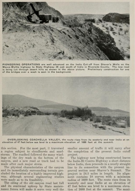
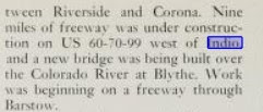
September 1934 California Highways & Public Works announced construction on the Indio-Cutoff Spur of LRN 64 had begun. The Indio-Cutoff was to serve as a new alignment of US Route 60/US Route 70 which would enter Coachella Valley via Dillon Road and would provide a bypass to the hazards of Box Canyon.


The
1935 Division of Highways Map of Riverside County depicts the original alignment of US Route 60/US Route 70/LRN 64 east from Mecca to the Arizona state line. The US Route 99/US Route 60/US Route 70 is shown splitting in Coachella. US Route 99 split via what is Cesar Chavez Street on LRN 26 towards El Centro whereas US Route 60/US Route 70 followed Grapefruit Boulevard on LRN 64 towards Mecca and Box Canyon. From Box Canyon, US Route 60/US Route 70/LRN 64 continued east over Chiriaco Summit towards Chuckwalla Valley. US Route 60/US Route 70/LRN 64 eastbound passed through Chuckwalla Valley along what is now Chuckwalla Valley Road towards Bylthe. Within Blythe US Route 60/US Route 70/LRN 64 followed Hobsonway to the Colorado River Bridge at the Arizona state line.


The
July 1935 California Highways & Public Works featured the opening of the Indio-Cutoff and realignment of US Route 60/US Route 70 onto the new spur of LRN 64. The Indio-Cutoff is stated to have opened in June 1935, five months ahead of schedule. The Indio-Cutoff is stated to be 9 miles shorter than the original alignment of US Route 60/US Route 70 through Box Canyon. Despite Box Canyon no longer being part of US Route 60/US Route 70, it would remain under State maintenance.


In a letter dated October 4, 1938, the Nevada State Highway Engineer requested information from the AASHO Executive Secretary pertaining to a 1937 request to extend US Route 95 through Nevada to Blythe, California. The origin point for the proposed extension of US Route 95 is shown to be the Idaho Oregon Nevada Highway (I.O.N. Highway #456) at McDermitt at the Oregon/Nevada state line. The AASHO Executive Secretary replied on October 8, 1937, indicating that the Oregon Department of Transportation stated I.O.N. #456 was not ready to facilitate modern automotive travel. The AASHO Executive Committee's opinion was to hold off on the extension of US Route 95 until I.O.N Highway #456 was completed in Oregon.

On May 20, 1939, the Nevada State Highway Engineer again petitioned the AASHO Executive Committee to extend US 95 through Nevada. The Nevada State Highway Engineer noted Nevada State Route 8 had been fully paved from Winnemucca to the Oregon State Line since 1936 and was ready to be assigned as US Route 95 despite I.O.N. Highway #456 needing to be completed.
The Nevada State Highway Engineer's letter was met with a reply by the AASHO Executive Secretary on May 24, 1939. The Executive Secretary stated once notification of the completion of I.O.N. Highway #456 was received from the Oregon Department of Transportation the AASHO Executive Committee would likely take action to extend US Route 95.
A letter dated June 2, 1939, from the AASHO Executive Secretary to the State Highway engineers of; California, Nevada, Oregon and Idaho noted the proposed alignment of US Route 95 south to Blythe, California. A separate letter to the Nevada State Highway Engineer notes that a last-minute request was made to extend US Route 93 south of Las Vegas to the California State Line via Searchlight over Nevada State Route 5 instead of US Route 95.
A letter dated June 10, 1939, by the AASHO Executive Secretary to the President of the AASHO states that the Nevada State Highway Engineer attempted to get US Route 95 into Nevada before the completion of I.O.N. Highway #456 under the pretenses that a like interim measure was permitted for the extension of US Route 6 to California. I.O.N Highway #456 is noted to have an anticipated completion sometime during 1940.

The AASHO Executive Secretary advised the Highway Engineers of California, Nevada, Oregon, and Idaho in a letter dated July 7, 1939, that the AASHO Executive Committee approved the extension of US Route 95 to Blythe, California. US Route 95 absorbed the existing routing of California State Route 195/LRN 146 from the Nevada State Line south to US Route 60/US Route 70/LRN 64 at Hobson Way in Blythe. Upon the extension of US Route 95 into California the original California State Route 195 was deleted. The California State Route 195 number was reassigned to the former routing of US Route 60/US Route 70 via the spur of LRN 64 in Box Canyon.
On June 29, 1956, the Federal Highway Aid Act of 1956 was signed into law on the Federal Level. The Federal Highway Aid Act of 1956 was the genesis point of the Interstate Highway System which would in the coming decade sew the demise via US Route 60 and US Route 70 from the Colorado River west Coachella Valley by way of being replaced by Interstate 10.
The
November/December 1958 California Highways & Public Works noted US Route 60/US Route 70/LRN 64 from Indio-Cactus City was under study to expand to freeway standards. US Route 60/US Route 70/LRN 64 from Cactus City east to the Arizona State Line is stated to have had a freeway alignment adopted by the California Highway Commission.


US Route 95 was approved to be extended from Blythe to the Mexican border at San Luis, Arizona, by the AASHO Executive Committee on June 28, 1960. US Route 95 from Intake Boulevard multiplexed US Route 60/US Route 70 and planned Interstate 10 along Hobsonway to the Colorado River and Arizona state line. The extension of US Route 95 to the Mexican border was desired by the Arizona Highway Department and was not objected by the Division of Highways.
The
November/December 1961 California Highways & Public Works announced the new Colorado River Bridge carrying US Route 60/US Route 70/US Route 95/Interstate 10 into Arizona east of Blythe was recently completed. Construction costs for the new Colorado River Bridge were shared by the states of California and Arizona. The new span replaced the earlier 1928 structure.
US Rout 70 was approved to be truncated from Los Angeles to US Route 95 in Blythe by AASHO on August 26, 1963. The truncation of US Route 70 left only US Route 60 and Interstate 10 as the only signed routes west of Blythe to Coachella Valley on LRN 64. LRN 64 would be dropped along with all the Legislative Route Numbers as part of the 1964 State Highway Renumbering.


The 1964 Division of Highways Map displays the impact of the 1964 State Highway Renumbering and 1963 changes to the US Route System. US Route 99 is shown truncated to Los Angeles and California State Route 86 replacing it between Indio-Heber. US Route 70 is displayed as being truncated out of Coachella Valley to US Route 95 in Blythe. Interstate 10 and US Route 60 are shown running concurrently west of Blythe to Coachella Valley.
The 1964 State Highway Renumbering was the impetus for the creation of California State Route 60. California State Route 60 was defined as originating at Route 10 near Soto Street in Los Angeles River to Route 10 near Beaumont. The definition of California State Route 60 first appears on the 1964 Division of Highways Map. Much of the interim and planned routing of California State Route 60 west of Pomona was independent of any alignment of US Route 60.


The AASHO Executive Committee approved US Route 60 to be truncated from downtown Los Angeles to US Route 95 in Blythe on October 2nd, 1965. The truncation of the US Route to Blythe left only Interstate 10 on what had been the corridor of US Route 99/US Route 60/US Route 70.


The California Highways & Public Works publication ended in 1967 prior to Interstate 10 through Indio being completed. Interstate 10 appears on the
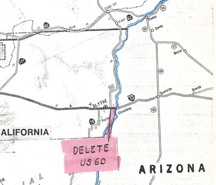
1967 Division of Highways Map with a determined freeway routing that would bypass Indio and would connect with a planned freeway to Thermal. Interstate 10 is shown following an interim alignment through Indio from the Indio Rail Overhead along Indio Boulevard and Dillon Road to the Indio-Cutoff. Interstate 10 is shown complete following a portion of the Indio-Cutoff to the vicinity of Box Canyon Road. Interstate 10 is shown to have a determined realignment in Chuckwalla Valley in addition to Blythe. The interim alignment of Interstate 10 east of Intake Boulevard in Blythe is shown to be concurrent with US Route 60 and US Route 95 to the Colorado River Bridge.


The
1969 Division of Highways Map displays Interstate 10 being upgraded to freeway standards from Box Canyon Road east through Chuckwalla Valley. The new alignment of Interstate 10 through Chuckwalla Valley bypassed former US Route 60/US Route 70 along Chuckwalla Valley Road and Ragsdale Road in Desert Center.
On June 24, 1969, AASHO approved an Arizona Highway Department request to truncate US Route 70 from the California State Line to Globe, Arizona. The truncation of US Route 70 removed it from the multiplex of US Route 95/US Route 60 and Interstate 10 between Blythe to Quartzsite, Arizona.
During the early 1970s, Interstate 10 in Coachella was upgraded to freeway standards and the bypass of Blythe was constructed. Interstate 10 is shown completed between the Colorado River west to Coachella Valley on the
1975 Caltrans Map.
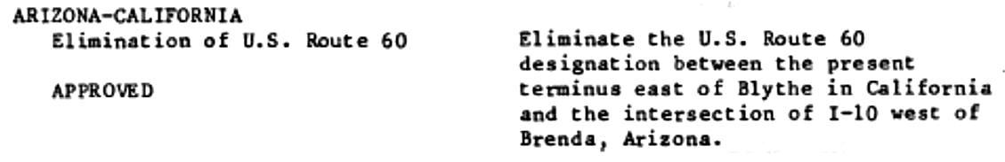
AASHTO (now the American Association of State Highway Transportation Officials) deferred a Caltrans request to truncate US Route 60 between US Route 95 in Blythe and the Arizona state line on June 29, 1982. The request to truncate US Route 60 from Blythe was deferred pending a like application from Arizona. Caltrans noted in their request that US Route 60 was not signed along US Route 95/Interstate 10 east of Blythe to the Arizona state line.
US Route 60 was officially deleted in California during their
November 1982 meeting. US Route 60 was truncated from US Route 95 in Blythe to Interstate 10 near Brenda, Arizona.
Part 2; visiting the last terminus of US Route 60 in California
The final terminus of US Route 60 in California was located in Blythe along what is now Interstate 10 and US Route 95. Interstate 10 westbound enters Blythe, California via the Colorado River Bridge multiplexed with northbound US Route 95. Upon entering California, Interstate 10/US Route 95 passes through a California Agricultural Station.
Interstate 10/US Route 95 intersects the original surface alignment of US Route 60/US Route 70 in Blythe at Exit 242.
US Route 95 northbound departs from Interstate 10 westbound at Exit 241 at Intake Boulevard in Blythe. Exit 241 was the last terminus of US Route 60 in California when it was finally removed from the state in 1982.


Comments