Anaheim of Orange County, California was the crossroads of numerous major highways. Anaheim was traditionally part of the corridor of US Route 101 which originally was aligned along Los Angeles Street (now Anaheim Boulevard). During 1934 California State Route 18 was aligned through Anaheim via Center Street and was joined by California State Route 10 on the Manchester Boulevard Extension during 1937. California State Route 10 in Anaheim was replaced by US Route 101 Bypass by 1940 and US Route 91 began to multiplex California State Route 18 by 1947.
The original highway alignments through Anaheim were replaced by the developing corridors of the Santa Ana Freeway and Riverside Freeway during the 1950s-1960s. This blog will explore the history of Signed Highway alignments through the city of Anaheim. Featured as the blog cover is a then new segment of California State Route 10 along the Manchester Boulevard Extension in Anaheim from the May 1937 California Highways & Public Works.
Part 1; the history of the Signed Highway alignments of Anaheim
Anaheim was founded in what was then southern Los Angeles County during 1857. The location of Anaheim selected due to it being near fertile agricultural lands. Anaheim was plotted around what is now South Street, West Street, North Street and East Street. Anaheim would incorporate as a city on March 18, 1876. Orange County would eventually split from Los Angeles County during April 1889.
The era of State Highway Maintenance in the Anaheim corridor would begin with the 1909 First State Highway Bond Act which was approved by voters in 1910. One of the highways approved through the 1909 First State Highway Bond Act was a 481.8-mile highway originating at the City Limits of San Francisco which terminated in San Diego. This highway would ultimately come to be known in time as Legislative Route Number 2 ("LRN 2").
The January 1915 California Highway Bulletin references LRN 2 from the Los Angeles/Orange County line to Anaheim as being completed between to State standards.
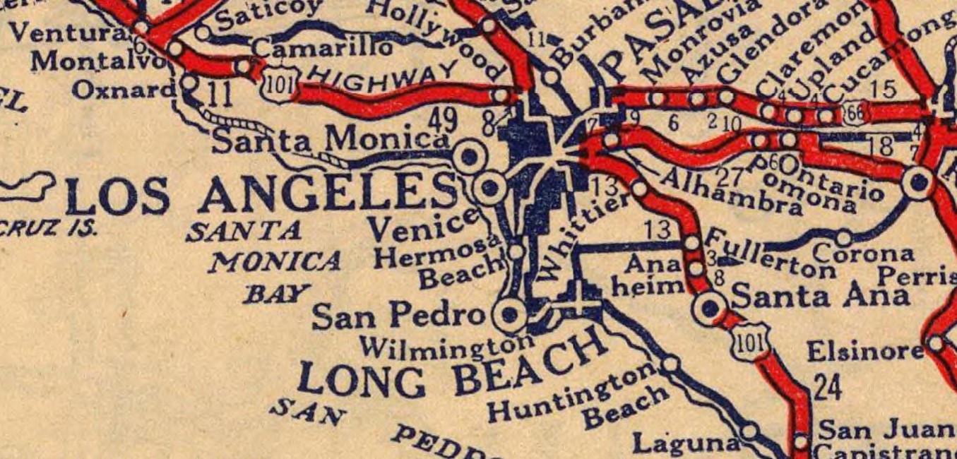
Prior to 1933 the State of California could not actively maintain highways in incorporated cities. LRN 2 can be seen following Whittier Boulevard, Spadra Road (now Harbor Boulevard and La Palma Parkway) and Los Angeles Street (now Anaheim Boulevard) from the Los Angeles city limit to downtown Anaheim on the 1917 California State Automobile Association Map. LRN 2 can be seen passing through the communities of Montebello, Whittier, La Habra and Fullerton.

LRN 2 between Los Angeles and Anaheim is shown as part of the Old Spanish Trail on the 1924 Rand McNally Map of California.


During November 1926 the US Route System was created by the American Association of State Highway Officials (AASHO and later AASHTO). US Route 101 was applied to the existing corridor of LRN 2 between Los Angeles and Anaheim. US Route 101 can be seen following LRN 2 between the Los Angeles city limit to Anaheim on the 1927 Rand McNally Map of California.
During 1933
LRN 178 and
LRN 174 would both be defined as highways passing through Anaheim. LRN 178 was defined as from "Cerritos Avenue to LRN 43 near Olive via Anaheim." LRN 174 was defined as "LRN 60 via Manchester Avenue to LRN 2/US Route 101 near Miraflores." LRN 178 would pass through the city of Anaheim via Center Street (partially now Lincoln Avenue) whereas LRN 174 was part of the then unfinished Manchester Boulevard Extension. LRN 178 and LRN 174 can be seen for the first time on the
1934 Division of Highways Map.


US Route 101/LRN 2 between the Los Angeles city limit to Anaheim can be seen on the 1935 Division of Highways Maps of
Los Angeles,
Los Angeles County and
Orange County. US Route 101/LRN 2 can be seen approaching Whitter Boulevard via Boyle Avenue in Los Angeles. From Los Angeles, US Route 101/LRN 2 is shown following Whittier Boulevard to La Habra in Orange County via Montebello and Whittier. US Route 101/LRN 2 is seen departing La Habra via Spadra Road towards Anaheim via Fullerton. US Route 101/LRN 2 is shown passing through Anaheim via Los Angeles Street south towards Santa Ana. California State Route 18/LRN 178 can be seen passing through Anaheim on Center Street.


The
May 1937 California Highways & Public Works discusses the opening the final segment of the "Manchester Boulevard Extension" which was dedicated on April 30, 1937. The Manchester Boulevard Extension provided a direct link between Downey and Anaheim which followed the Southern Pacific Railroad. The Manchester Boulevard Extension bypassed downtown Anaheim and tied into existing alignment of California State Route 10/LRN 174 on southern Manchester Boulevard at Miraflores near the outskirts of Santa Ana. The Manchester Boulevard Extension is stated to have been conceptualized during 1924 by the Greater Manchester Avenue Improvement Association. The Manchester Boulevard Extension concept was taken over by the Division of Highways when LRN 174 was added as a State Highway circa 1933.
California State Route 10/LRN 174 can be seen in detail on the
1938 Division of Highways State Map. CA 10/LRN 174 is shown to originate at US Route 101A/LRN 60 in Los Angeles County. California State Route 10/LRN 174 is shown following Manchester Boulevard and Firestone Boulevard eastward to US Route 101/LRN 2 south of Anaheim of Orange County.
US Route 101 Bypass appears co-signed with California State Route 10/LRN 174 on the
1940 Division of Highways Map from CA 19/LRN 168 on Rosemead Boulevard in Downey to US Route 101/LRN 2 near Anaheim. It is unclear when US Route 101 Bypass in the Los Angeles Area was created due to it not appearing anywhere in the AASHTO Database. US Route 101 Bypass is shown departing US Route 101/LRN 2 in Los Angeles via LRN 166/Indiana Street and LRN 166/Anaheim-Telegraph Road to California State Route 19/Rosemead Boulevard.
California State Route 10 is shown to be truncated to an eastern terminus at US Route 101 Bypass/California State Route 19 at Rosemead Boulevard in Downey on the
1942 Division of Highways Map. A planned extension of LRN 166/Anaheim Telegraph Road appears for the first time.
On July 1, 1947, the AASHO Executive Secretary notified the California State Highway Engineer that California's request to extend
US Route 91 from Barstow to Long Beach had been approved. The extension of US Route 91 to Long Beach brought it through Anaheim along Center Street via a multiplex of California State Route 18/LRN 178.
US Route 91 can be seen multiplexing California State Route 18 on Center Street in Anaheim on the
1948 Division of Highways Map.

The
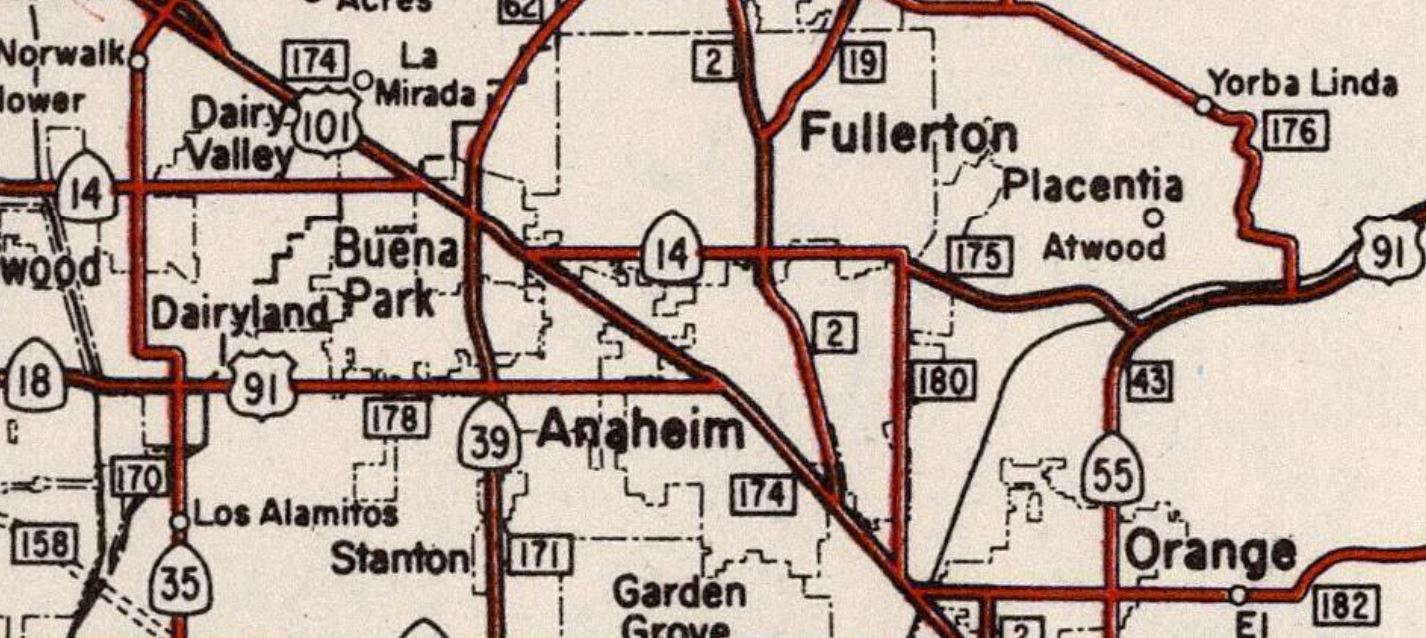
1954 Division of Highways Map shows the Santa Ana Freeway completed to Pioneer Boulevard near Norwalk. Mainline US Route 101 is shown realigned onto the Santa Ana Freeway (LRN 166), an interim routing on Pioneer Boulevard and Firestone Boulevard/Manchester Boulevard (LRN 174) between Los Angeles-Anaheim. The former mainline of US Route 101 on LRN 2 is shown to no longer be part of the highway. 1953 Legislative Chapter 1836 truncated the eastern terminus of LRN 178 to the new mainline routing of US Route 101 along Manchester Boulevard in Anaheim. Despite LRN 178 being relinquished between US Route 101/LRN 174 and LRN 43 it appears as US Route 91/California State Route 18 through Anaheim via Center Street.


The
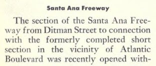
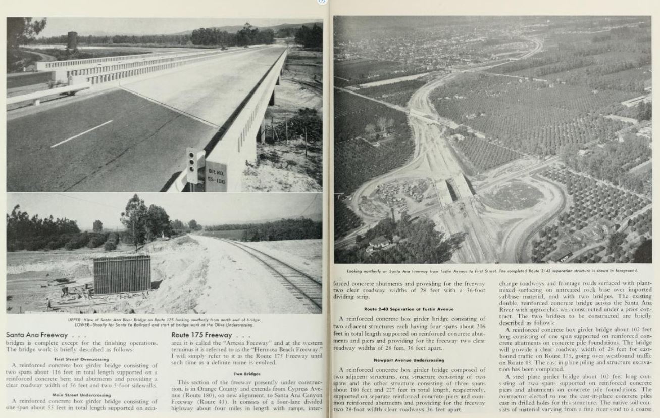
July/August 1955 California Highways & Public Works featured construction of US Route 101 along the Santa Aana Freeway south of Anaheim and the Route 175 Freeway (California State Route 14) east of LRN 180 to LRN 43. The Santa Ana Freeway between 1st Street and Browning Avenue near Santa Ana/Tustin is cited to be 70% complete. The Route 175 Freeway is noted to referenced locally as the "Orangethorpe Freeway" and approximately 50% complete.
The
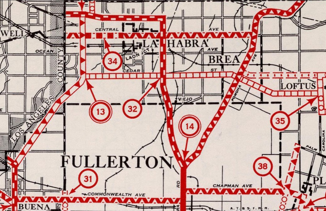
September/October 1955 California Highways & Public Works referenced US Route 101/LRN 174 between Ball Road northwest to Coyote Creek as being the last remaining segment of expressway in the Santa Ana Freeway corridor between Anaheim/Buena Park. The article references construction bids were to be taken by the state for the segment to be converted to freeway during fall 1955.
US Route 91 and California State Route 18 appear realigned onto California State Route 14/LRN 175 on the
1956 Division of Highways Map north of downtown Anaheim. The interim routing of US Route 91/California State Route 18 from Lincoln Avenue followed US Route 101/Manchester Boulevard, Orangethorpe Avenue, Cypress Avenue (now State College Boulevard) and a completed segment of the Orangethorpe Freeway (east of LRN 180).
On June 29, 1956, the Federal Highway Aid Act of 1956 was signed into law on the Federal Level. The Federal Highway Aid Act of 1956 was the genesis point of the Interstate Highway System and would see the Santa Ana Freeway assigned to Interstate 5.
The
July/August 1956 California Highways & Public Works featured the opening of the Houston Expressway (California State Route 14/US Route 91/California State Route 18/LRN 175) east of LRN 180/Cypress Avenue to Santa Ana Canyon. An opening ceremony was held in Anaheim, but the article does not specify a date.
The
1957 Division of Highways Map displays California State Route 18 and US Route 91 realigned onto the Stanton Avenue Extension along California State Route 39/LRN 171 in Buena Park. Both highways briefly multiplexed US Route 101 towards California State Route 14/LRN 175 on Orangethorpe Boulevard.
The
January/February 1957 California Highways & Public Works referenced the Santa Ana Freeway (US Route 101) being completed through Anaheim through to southern Orange County. A construction photo displays the Santa Ana Freeway and a new interchange under construction at Lincoln Avenue.
The
January/February 1958 California Highways & Public Works announced the Houston Expressway had been renamed the "Riverside Freeway" by the California Highway Commission on October 25, 1957. The Riverside Freeway corridor was defined as from the Santa Ana Freeway was to Riverside. The article is one of the first overt references to both US Route 91 and California State Route 18 both being present on the completed portions of the Riverside Freeway. The article notes a segment of the Riverside Freeway from the Santa Ana Freeway east to LRN 2 at Spadra Avenue was under construction.
The
January/February 1958 California Highways & Public Works announced existing US Route 101 in Buena Park was being upgraded as part of the Santa Ana Freeway corridor. A contract to construct the Santa Ana Freeway between 10th Street in Buena Park to Palmer Avenue in Anaheim was awarded during 1957.
The
January/February 1959 California Highways & Public Works references the Santa Ana Freeway being completed through Buena Park during the previous year. The same volume references the Riverside Freeway from the Santa Ana Freeway east to LRN 2/Spadra Avenue as also being completed during 1958. An extension of the Riverside Freeway to Placentia Avenue is cited to be underway.
The
1962 Division of Highways Map displays California State Route 18 truncated from Long Beach to San Bernardino. The truncation of California State Route 18 removed it from US Route 91/California State Route 14/LRN 175 on the Riverside Freeway north of downtown Anaheim.
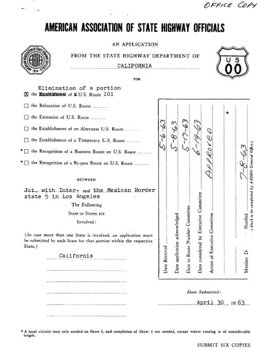
On June 19, 1963, AASHO approved a Division of Highways request to truncate US Route 101 from the Mexican Border to downtown Los Angeles. This measure removed US Route 101 from the Santa Ana Freeway in Anaheim and left Interstate 5 as a standalone route designation.
US Route 91 was requested by the Division of Highways to be truncated to Barstow during 1963. The truncation of US Route 91 to Barstow appears in a letter written by the State Highway Engineer to the AASHO Executive Secretary dated August 26, 1963.
As part of the 1964 State Highway Renumbering the Legislative Route Numbers were deleted in favor of Sign Route designations. Former US Route 101/LRN 2 in the Los Angeles-Anaheim corridor were reassigned as
California State Route 72. California State Route 72 was defined as beginning at Interstate 5 in Anaheim and ending at California State Route 245 near Los Angeles. California State Route 91 was reassigned to the corridor of former US Route 91 through Anaheim on the Riverside Freeway. The initial definition of California State Route 91 had it originate at California State Route 1 east to US Route 395 in Riverside. The former segment of US Route 91 west of the Santa Ana Freeway (Interstate 5) to California State Route 19 was redefined as
California State Route 214.
California State Route 72, California State Route 91 and California State Route 214 can be seen for the first time on the
1964 Division of Highways Map.
1965 Legislative Chapter 1372 changed the northern terminus of California State Route 72 to Downey Road which reflected the deletion of the original California State Route 245. The same Legislation added numerous stipulations to California State Route 72:
(A) The portion of Route 72 from Route 5 in or near Anaheim to Route 39 shall cease to be a state highway when Route 57 freeway in the Cities of Fullerton and Brea and the County of Orange is completed and commission relinquishes present Route 57 in the Cities of Fullerton and Brea and the County of Orange.
(B) The portion of Route 72 from Route 39 to Downey Road shall cease to be a state highway when Route 90 freeway is completed from Route 5 to Route 39.

1965 Legislative Chapter 1372 added a stipulation to the definition of California State Route 214:
"This route shall cease to be a state highway when Route 91 freeway is completed from Route 19 to Route 5 and the commission relinquishes that portion of present Route 91 from Route 19 to Route 5."
The stipulation set by 1965 Legislative Chapter 1372 was acted upon as part of 1981 Legislative Chapter 292 which deleted California State Route 214 from the State Highway System.
1981 Legislative Chapter 292 truncated California State Route 72 to "Route 39 to Downey Road near Los Angeles."
Part 2; a drive on the original alignment of US Route 101 in Anaheim
As noted in Part 1 what is now Anaheim Boulevard was originally Los Angeles Street and the original alignment of US Route 101 in Anaheim. US Route 101 would have intersected California State Route 10 and later US Route 101 Bypass at Manchester Boulevard roughly where Interstate 5 now crosses over Anaheim Boulevard.
US Route 101 would have followed Anaheim Boulevard into downtown Anaheim and would have intersected the street running Southern Pacific Railroad at Santa Ana Street. The original mainline of the Southern Pacific Railroad ran along Interstate 5 south of Santa Ana Street but was razed to make way for the Manchester Boulevard Extension of California State Route 10/US Route 101 Bypass.
US Route 101 along Anaheim Boulevard in downtown Anaheim would have intersected US Route 91/California State Route 18 at Center Street.
Part 3; a drive on former US Route 91 and California State Route 18 along Center Street in downtown Anaheim
As noted in Part 1 US Route 101 along Los Angeles Street would have intersected US Route 91/California State Route 18 at Center Street. Center Street west of Los Angeles Street (Anaheim Boulevard) west towards Harbor Boulevard razed during the 1970s to make way for the
Center Street Promenade.
Construction of the Center Street Promenade saw Lincoln Avenue realigned to the north from Harbor Boulevard towards Atchison Street. Traffic can now only take Center Street east from Anaheim Boulevard to Atchison Street.
Center Street now terminates at the 1923 Atchison, Topeka and Santa Fe Railway depot. The depot was originally located several hundred yards to the north before Lincoln Avenue was elongated as a bypass of Center Street.


Comments