
Arizona State Route 89L was a 3.41-mile state highway which once existed in the city of Page. Arizona State Route 89L served as loop of US Route 89 which followed Lake Powell Boulevard. Arizona State Route 89L was commissioned during 1968 and was ultimately abandoned during 2001. Despite Arizona State Route 89L essentially serving as a business loop of US Route 89 a formal designation was never sought with the American Association of State Highway Officials. Arizona State Route 89L is the only Arizona State Highway to carry an "L" suffix. Featured as the blog cover is the 1985 United States Geological Survey Map of Page which depicts Arizona State Route 89L as "US Route 89 Loop."
The history of Arizona State Route 89L
Page was founded during 1957 as a town to house workers constructing Glen Canyon Dam. Construction of Glen Canyon Dam and Page came in conjunction with a new highway over the Colorado River. This culminated with the completion of Glen Canyon Dam Bridge in 1959. Glen Canyon Dam Bridge is a 1,271-foot-long span which has a 700-foot clearance above the Colorado River. Glen Canyon Dam Bridge can be seen below in a series of photos taken during 2010.


Following completion of Glen Canyon Dam Bridge, the Arizona State Highway Commission would submit an application to American Association of State Highways Officials (AASH) to realign mainline US Route 89 onto the structure. The application to realign US Route 89 through Page and over Glen Canyon Dam Bridge was approved by the AASHO Executive Committee on June 11, 1959. A secondary part of the request was to establish US Route 89 Alternate over the original routing of US Route 89 over the Navajo Bridge towards Fredonia.


Glen Canyon Dam was completed during 1966. The Arizona State Highway Commission established Arizona State Route 89L on February 21, 1968. Arizona State Route 89L was established as a loop of US Route 89 along what is now Lake Powell Boulevard. It is unclear why the Arizona State Highway Commission never sought an official US Route 89 Business Loop designation from AASHO.

The Glen Canyon National Recreation Area was established on October 27, 1972. During 1974 the Arizona State Highway Commission adopted Navajo Route 22 as Arizona State Route 98. The original northern terminus of Arizona State Route 98 was located at Arizona State Route 89L via Coppermine Road.
Page would incorporate formally on March 1, 1975. Arizona State Route 89L appears as "US Route 89 Loop" along Lake Powell Boulevard on the 1985 United States Geological Survey map of Page.
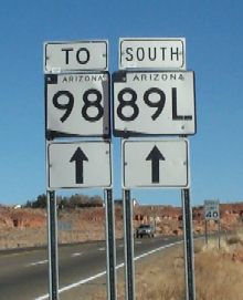
One of the few known images of an Arizona State Route 89L sign can be seen hosted on arizonaroads.com.
The 1998 Arizona Department of Transportation logbook note Arizona State Roure 89L was 3.41 miles long. Mileage on Arizona State Route 89L is noted to have been continuous with US Route 89.

Arizona State Route 98 was realigned south of Page during 1998. The new alignment of Arizona State Route 98 shifted it away from Arizona State Route 89L to a new terminus at US Route 89.

Arizona State Route 89L was abandoned by the Arizona Department of Transportation on December 14, 2001. Lake Powell Boulevard was relinquished back to the city of Page for maintenance.

Comments