Former US Route 99 in Dunsmuir of southern Siskiyou County, California was located on Dunsmuir Avenue. Pictured above is former US Route 99 on Dunsmuir Avenue in downtown Dunsmuir as it appeared in the September/October 1951 California Highways & Public Works. Below is a image from the 1935 Division of Highways Map of Siskiyou County which depicts US Route 99 on Dunsmuir Avenue.
This blog is part of the larger Gribblenation US Route 99 Page. For more information pertaining to the other various segments of US Route 99 and it's three-digit child routes check out the link the below.
Part 1; the history of US Route 99 in DunsmuirThe first documented European travel through the present site of Dunsmuir and Sacramento River Canyon came in 1828 when it was explored by Hudson Bay trapper Alexander McLeod. The travels of Alexander McLeod through Alta California established what came to be known as the "Siskiyou Trail" between what is now Oregon and California by way of the Sacramento River Canyon. The present site of Dunsmuir later became part of a major 1837 cattle drive to Oregon along the Sacramento River Canyon via the Siskiyou Trail. The 1837 cattle drive was followed by a 1841 mapping survey of the Sacramento River Canyon which documented much of the path of the Siskiyou Trail. The Siskiyou Trail would become a major path of emigrant travel following the finding of Gold at Sutter's Mill in 1848 and the emergence of the State of California during the California Gold Rush.
Gold was discovered at what became the City of Yreka in 1851 which was followed by numerous other claims in Scott Valley. The formation of the California-Oregon Trail saw much of the Siskiyou Trail in the Sacramento River Canyon bypassed to the west via; Scott Valley, Scott Mountain and the town of Shasta. Nonetheless the Sacramento River Canyon and Siskiyou Trail remained an established path of travel. In 1855 a tolled bridge over the Sacramento River was built at Upper Soda Springs immediately north of modern Dunsmuir by settlers Ross and Mary McLeod. The Siskiyou Trail would be improved by 1860 to a road capable of handing Stage Travel from Upper Soda Springs to Yreka and southward through the Sacramento River Canyon by 1870. Upper Soda Springs in time became a stage stop and resort which catered to travelers on the Siskiyou Trail. The Upper Soda Springs resort can be seen circa 1875-1880 in the public domain drawing below.

In 1886 the Southern Pacific Railroad completed a line through the Sacramento River Canyon towards Oregon. A roundhouse and railyard at Upper Soda Springs was constructed which led to the creation of a siding known as "Pusher" in 1887. The community name of Pusher changed in 1888 in when coal magnate Robert Dunsmuir offered to build a fountain at the town site. The donation for fountain construction was contingent upon the community assuming the name of
Dunsmuir. Dunsmuir can be seen on the Southern Pacific Railroad on the 1892 Rand McNally Map of California.
According to dunsmuir.com the main street in Dunsmuir was once Sacramento Avenue (originally Front Street) along the Southern Pacific Railroad. A fire which occurred in 1903 wiped out much of the existing buildings which have been since replaced by the present structures. Dunsmuir would incorporate as a City on August 7th, 1909.
The emergence of the automobile in the early 20th Century in California led to the 1909 First State Highway Bond Act which was approved by voters during 1910. The majority of the highways approved as part of the First State Highway Bond Act were largely well established routes of travel. One such highway was
Legislative Route Number 3 ("LRN 3") which was defined as a highway from "Sacramento to the Oregon Line."
The construction of LRN 3 in Siskiyou County connected with Back Street in Dunsmuir with the first automobiles arriving in 1912 according to dunsmuir.com. Back Street eventually came to be known as "Florence Avenue" following the construction of LRN 3 and would later become "Dunsmuir Avenue." By 1913 the Pacific Highway was created as a major Auto Trail between San Diego and Vancouver, British Columbia. LRN 3 and the Pacific Highway were shifted onto a new alignment between Dunsmuir and Weed in 1915 replacing what is now known as Old Stage Road (the Siskiyou Trail). The Pacific Highway followed LRN 3 from the Oregon State Line south through Dunsmuir via Florence Avenue. A very early LRN 3 through Dunsmuir on Florence Avenue can be seen on the
1917 California State Automobile Association Map.

According to dunsmuir.com much of Florence Avenue burned in 1924 which at the time mostly contained residential structures. The fire saw Florence Avenue reconstructed as a new downtown commercial district which largely usurped Sacramento Avenue due to it being located on the Pacific Highway/LRN 3.
The initial draft of the US Route System was approved by the Secretary of Agriculture during November of 1925. The US Route System within California was approved by California Highway Commission ("CHC") with no changes recommended by
January 1926. The initial alignment of US Route 99 ("US 99") was largely planned to follow the Pacific Highway from the Oregon State Line south to Sacramento Valley. US 99 is shown on a map published in the 1926 California Highways & Public Works following LRN 3 through Florence Avenue in Dunsmuir.
Thusly US 99 appears on the 1925 Rand McNally Map of California as being routed through Dunsmuir via Florence Avenue.
During November of 1926 the US Route System was approved by the AASHO. US 99 can seen aligned through Dunsmuir on the
1927 National Map Company Sectional Map.
The undated
postcard below depicts early US 99/LRN 3 facing northbound on Florence Avenue.


The
May/June 1953 California Highways & Public Works depicts the progress of the freeway conversion of US 99/LRN 3 between Dunsmuir and Big Canyon. Work on grading the freeway conversion of US 99/LRN 3 is stated to have begun during May of 1952 which ran continuously until being shut down for winter during the following December. The antiquated 1915 Sacramento River Bridge at the north entrance to Dunsmuir is depicted in several photos.
On June 29th, 1956 the Federal Highway Aid Act of 1956 was signed into law on the Federal Level. The Federal Highway Aid Act of 1956 was the genesis point of the Interstate Highway System which would in the coming decade sew the demise via of US 99 north of Redding Bluff to the Oregon State Line via replacement by Interstate 5.
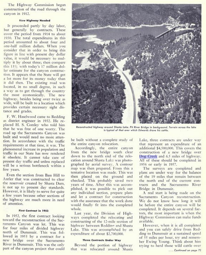
The reconstruction of US 99/LRN 3 in the Sacramento River Canyon along with much of it's history as a transportation corridor is discussed in the May/June 1956 California Highways & Public Works. The first contract to rebuild US 99/LRN 3 in the Shasta River Canyon came in 1952 which was for 4 miles of divided highway north of Dunsmuir. This was followed by a new contract in 1953 to construct a new bridge over the Sacramento River in Dunsmuir. 12 miles of US 99/LRN 3 north from Redding to Shasta Lake City were cited to have been completed in 1955. The article goes on further in terms of describing three ongoing contracted projects in the Sacramento River Canyon which included a new bridge over Dog Creek and 6.5 miles of additional highway. Surveys for reconstructing the remaining 19 miles of US 99 between Shasta Lake and Dunsmuir were cited to be underway.
The May/June 1958 California Highways & Public Works also announced that the first full freeway segment of US 99/LRN 3 in the Sacramento River Canyon (and Division of Highways District II) was planned be constructed from the Shasta/Siskiyou County Line north through Dunsmuir to the Sacramento River Bridge.
The
July/August 1960 California Highways & Public Works depicts the ongoing construction of the Dunsmuir Freeway bypass. The freeway bypass of Dunsmuir is shown to be largely built above downtown and existing US 99/LRN 3 corridor on Dunsmuir Avenue via a large excavated cut in the terrain.
The
November/December 1960 California Highways & Public Works stated that new freeway alignment of US 99/LRN 3 bypassing Dunsmuir was recently opened to traffic. Two projects south of Dunsmuir are stated to be nearing completion which would provide a continuous freeway-expressway north from Shasta Lake to Dunsmuir.
The
May/June 1963 California Highways & Public Works announced the four lane conversion of US 99/LRN 3 six miles south of Castella in the Sacramento River was completed. The Castella stub was the last segment of four lane freeway-expressway to be completed from Shasta Lake north to Dunsmuir.


On New Year 1964 the California State Highway Renumbering took effect. The California State Highway Renumbering sought to eliminate all the Legislative Route Number designations in favor field signage, renumber certain highways to avoid duplication with the Interstates, eliminate suffixed routes and trim US Routes that did not cross the State Line. US 99 was initially retained upon the California State Highway Renumbering taking effect.
The AASHO database shows that US 99 was approved to be truncated out of California by the AASHO Executive Committee on June 29th, 1965. This measure would have become effective on New Years Day 1966 and made the freeway bypass of Dunsmuir solely part of Interstate 5.
Part 2; a drive on former US Route 99 on Dunsmuir Avenue in Dunsmuir
From modern Interstate 5 northbound the alignment of former US 99 on Dunsmuir Avenue can be accessed via Exit 729. Historic US Route 99 signage can be observed along with signage for the Dunsmuir Historic District departing Interstate 5.
Interstate 5 Exit 729 transitions on former US 99 on Dunsmuir Avenue. Historic US 99 signage directs traffic northward towards downtown Dunsmuir.
Dunsmuir Avenue northbound quickly enters the City Limits of Dunsmuir.


Upon entering downtown Dunsmuir signage for Interstate 5 Business can be found along Dunsmuir Avenue.
Former US 99 northbound passes through downtown Dunsmuir via Dunsmuir Avenue. The commercial structures along Dunsmuir Avenue are still very much apparent given their late 1920s era designs.
Northbound Dunsmuir Avenue departs downtown Dunsmuir looping back to Intestate 5 near Spring Street. Former US 99 on Dunsmuir Avenue continues north of Dunsmuir over the Sacramento River towards Upper Soda Springs and Dunsmuir-Mott Municipal Airport.
Further Reading
Continuing north on US Route 99 to Mount Shasta?
Continuing south on US Route 99 through the Sacramento River Canyon and Lake Shasta?


Comments